Select units of measurement for the temperature and rainfall tables (metric or imperial).
Average weather, temperature, rainfall, sunshine
In Turkey, the climate is
Mediterranean on the west and south coasts,
transitional Mediterranean in Istanbul and on the north coast, and
continental in the inland areas (see Ankara), occupied by a plateau.
There are also
mountainous areas, which have a colder climate, and an area characterized by scorching summers in the southeast (upper Mesopotamia or al-Jazira).
The
rains are more abundant on the north coast, facing the Black Sea, where they generally exceed 1,000 millimeters (40 inches) per year, while the plateau is arid, in fact, less than 500 mm (20 in) of rain usually fall per year.
In winter, there can be snow and frost on the plateau, and more rarely on the Black Sea coast.
Summer is dry and sunny throughout the country, except in the eastern part of the Black Sea coast. In all the inland and south-central regions, the driest months are July, August and September.
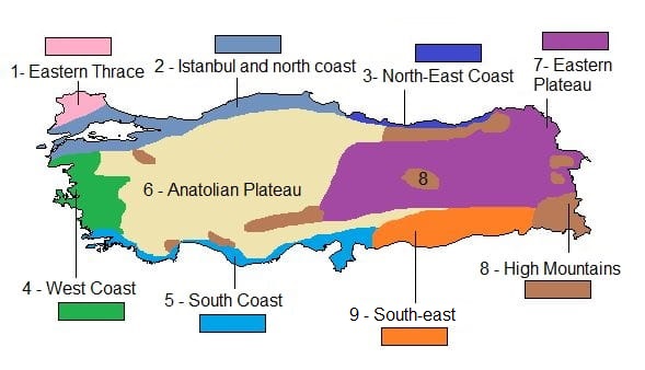
The climate in detail
1- Eastern Thrace
In this area of Turkey, south-east of Bulgaria, where the city of
Edirne (the ancient Adrianople) is located, the climate is
slightly continental. Winters are quite cold, with a January average around 3.5 °C (38 °F), and summers are hot, with highs of 33 °C (91.5 °F) in July and August, though tempered by the breeze. Here, cold spells with snow and frost may occur in winter as well as heat waves in summer.
Precipitation is not abundant, and there is a relative minimum in summer, when, however, brief thunderstorms may occur.
The sun is seen quite rarely in winter, while in summer the sky is normally clear.
2- Istanbul and northern coast
In the area of Istanbul and
Bursa, in the small portion of European Turkey and in the area beyond the Sea of Marmara and the Straits of Bosphorus and Dardanelles (see
Çanakkale), the climate can be described as
transitional Mediterranean, with relatively cold winters and hot and quite sultry summers.
In
Istanbul, the average temperature in January is around 6.5 °C (43.5 °F), but sometimes cold air masses from the Balkan Peninsula or Russia reach this area, bringing some cold and rainy days, and even snow (in Istanbul, there are about 15 days per year with snow, mostly from December to March). Summer, when the average temperatures are around 25.5 °C (78 °F) in July and August, is the least rainy season, and August is the driest month, while autumn and winter are the rainiest seasons.
Precipitation amounts to 680 mm (26.5 in) per year.
The sun in Istanbul is rarely seen in winter, partly because fog can sometimes form, while in summer, the sky is often cloudless.
The sea in Istanbul, very cold in winter, becomes warm enough for swimming in July and August.

In the southern part of this climatic zone, the ruins of ancient Troy are found.
Along the
coast to the east of Istanbul (see
Samsun, Trabzon, Rize), winter is slightly milder, while summer becomes progressively rainier as you move to the east.
For example, in
Trabzon, the monthly average temperature ranges from 8 °C (46.5 °F) in February to 24.7 °C (76.5 °F) in August.
On average, 900 millimeters (35.5 inches) of rain fall per year, with a minimum in summer. The sun does not shine very often.
In Trabzon, the sea is slightly warmer than in Istanbul and is warm enough for swimming from July to September.

3- North-east Coast
In the easternmost part of the Turkish coast of the Black Sea, east of Trabzon, from
Rize to the border with Georgia, the climate can be defined as
almost oceanic: the average temperature is similar to that of Trabzon, but the rains are abundant in all seasons, so that even more than 2,000 mm (80 in) of rain fall per year. However, the summer rains are not continuous, but they are concentrated in periods of bad weather which last a few days.
In Rize, winter is milder than in the area of Istanbul, with less frequent snowfalls. The average temperature ranges from 7.5 °C (45.5 °F) in January and February, to 24.5 °C (76 °F) in August.
In Rize, as much as 2,300 mm of rain (90 in) fall per year.
The sun does not shine very often, even in July and August, when there are only 5/5.5 hours of sunshine a day.
4- West Coast
Along the west coast of Turkey, overlooking the Aegean Sea, where the remains of ancient Greek cities like Pergamum and Ephesus are found, the climate is
Mediterranean, with mild, relatively rainy winters and hot and sunny summers.
The summer is tempered by the breeze along the coasts and the islands of the Aegean Sea, though at times the breeze is replaced by a strong and persistent wind from the north, called
Meltem.
The amount of rainfall on the west coast goes between 670 and 1,000 millimeters (26 and 40 inches) per year, with a maximum in winter and a minimum in summer, when it almost never rains.
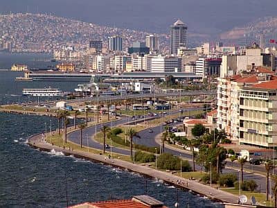
In
Izmir (or Smyrna), winter is mild, with an average in January around 8 °C (46.5 °F); cold waves may still occur, but they are shorter and rarer than in the area of Istanbul. There are on average only 3 days with snowfall per year.
Summer is sunny and hot. High-temperature records are around 43 °C (109.5 °F).
Precipitation amounts to 675 mm (26.5 in) per year.
The sun shines regularly in summer, while in winter there is an alternation between cloudy and sunny days.
Owing to the north wind that prevents the sea from warming in summer by mixing the water layers, the sea near Izmir is never very warm.
5- South Coast
Along the southern coast of Turkey (see
Bodrum,
Marmaris, Antalya,
Mersin), and in the short stretch of coast north of Syria (see Alexandretta), the climate is still
Mediterranean, though warmer than on the west coast, and even more so than on the Black Sea coast.
Winters are quite mild, with average highs around 15 °C (59 °F), while in summer, the maximum temperatures are definitely hot, ranging between 30 and 35 °C (86 and 95 °F).
Rainfall is concentrated from mid-October to mid-April, when it can be abundant, and can sometimes be torrential, particularly on the slopes facing west and southwest.
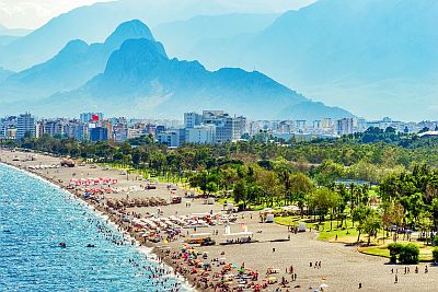
In
Antalya, the monthly average temperature ranges from 10.5 °C (51 °F) in January to as high as 29 °C (84 °F) in July and August.
In Antalya, about 1,050 mm (41.5 in) of rain fall per year, but it almost never rains from June to Spetember, while the rains are abundant in winter.
The sun shines quite often even in winter, except in periods of bad weather, while in summer the sky is normally clear.
The sea is warmer than in the north and west coast, and it's warm enough for swimming from June to October.
6- Anatolian Plateau
In the vast inland plateau, the climate is
continental, with significant variations both between night and day and between winter and summer. Precipitation is scarce, around 300/500 mm (12/20 in) per year, with a maximum in winter and minimum in summer, which is normally sunny. In this area, the climate is fairly uniform, and varies mainly with altitude, however, it becomes progressively more continental when going towards the east.
The capital of Turkey,
Ankara, is located in the northern part of the plateau, about 900 meters (3,000 feet) above sea level. Here, winter is cold and snowy, with a January average of 0.5 °C (33 °F), but the temperature can go down to -20 °C (-4 °F) during cold air outbreaks from Russia. Summer is hot and dry, sometimes scorching during the day, when temperatures can reach 38/40 °C (100/104 °F) in the worst moments, while nights remain generally cool.
In Ankara, annual precipitation is around 400 mm (15.5 in), so it's not abundant.
The sun is rarely seen in winter, while in summer it shines regularly.
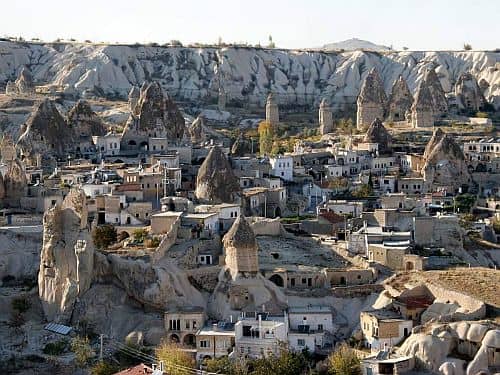
In this area, at about 1,100 meters (3,600 feet) above sea level, we find the region of
Cappadocia, where lies the city of Göreme, famous for the "fairy chimneys" or "earth pyramids". Here, the climate is similar to that of Ankara: the average January temperature is just below freezing (0 °C or 32 °F), and snow is quite frequent (the landscape of this region takes on an even more magical appearance under the snow), while the average in July and August is around 22 °C (72 °F), with highs around 30 °C (86 °F), but with possible scorching days.
7- Eastern Plateau
In the easternmost provinces, near the border with Georgia, Armenia and Iran, the climate is even more harsh, not only because of the higher altitude, which generally ranges between 1,200 and 1,600 meters (3,900 and 5,200 feet), but also because of the proximity to Russia, from which cold air masses can arrive; in fact, during winter this is one of the coldest areas not only of Turkey, but of the entire Europe.
Lake Van, at 1,600 meters (5,250 feet) above sea level (see
Van), is large enough to temper a little the climate, especially in winter, when the average temperature along its banks is around -4/-2 °C (25/28 °F), but further to the north, in the provinces of Erzurum and Kars, the January average drops to nearly -10 °C (14 °F) at 1,500 meters (5,000 feet).
The rainfall pattern in the eastern part of the plateau is similar to that of the central-western part: precipitation is not abundant, there are snowfalls in winter, while summers are dry.
Ss often happens in Turkey, the sun shines regularly in summer, while in winter there is an alternation between cloudy and sunny days.
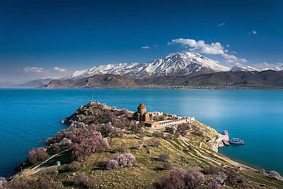
In
Erzurum, a city of 360,000 inhabitants in the north-east of Turkey, 1,700 meters (5,600 ft) above sea level, the average temperature in January is -10.5 °C (13 °F), so it's colder than in a northern Europe city like Helsinki. The absolute cold record is -41 °C (-41.8 °F), and that of April is still -22 °C (-7.5 °F). Summer is quite warm during the day, but nights remain cool, and sometimes even cold. There are, however, also hot days. The highest record is 36 °C (97 °F).
Precipitation is not abundant, only 400 mm (15.7 in) per year, with two minima in summer and winter and a maximum in spring. During winter, however, snowfall occurs quite often, and it can sometimes be abundant.
8- High Mountains
In Turkey, there are several mountainous areas, where the altitude exceeds 2,000 meters (6,500 feet). For instance, in the northwest, near Bursa, in the Olympus of Mysia (Uludag), you will find the most famous winter sports resorts of the country.
In addition, there are much higher mountains in the north-east (Pontus), in the south-west (Taurus), and in the eastern region, where we find Mount
Ararat, the highest mountain in Turkey, which stands out with its 5,165 meters (16,945 feet).
Here, the climate is Alpine, and of course the temperature decreases with altitude. At the highest altitudes, for instance on Mount Ararat, glaciers are found.
9- South-east
In the south-eastern provinces, near the border with Syria and Iraq, in upper Mesopotamia (or al-Jazira), where the upper courses of the Tigris and Euphrates rivers are located, in cities like Diyarbakir, Batman,
Sanliurfa, Cizre, the altitude ranges between 400 and 700 meters (1,300 and 2,300 feet). Here, the winter is quite cold, averaging a few degrees above freezing, but with possible snowfalls and frosts, which are more frequent in the northern part, but the main feature of this area is the
very hot summer, when temperatures can exceed 45 °C (113 °F).
In
Diyarbakir, 680 meters (2,200 feet) above sea level, the average temperature ranges from 2.5 °C (36.5 °F) in January to 30 °C (86 °F) in July. The lowest recorded temperature is -23 °C (-9.5 °F), while the highest is no less than 46 °C (115 °F).
Here too, precipitation is not abundant and is concentrated in the cold half of the year, while in summer, it rains very rarely.
In the south-east of Turkey too, the sun shines regularly in summer, while in winter, there is an alternation between cloudy days and sunny days.
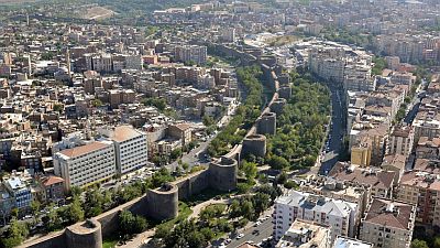
Further south, in
Cizre, at 400 meters (1,300 feet), near the border with Syria, the average maximum in July is as high as 41 °C (106 °F), while the daily average in January is 6.5 °C (43.5 °F), so winter is usually quite mild. Given its proximity to the mountains, the rains in Cizre are a bit more abundant, around 730 millimeters (29 inches) per year, but here too, in summer it rains very rarely.
When to go
Almost the whole of Turkey, except the north-eastern coast, enjoys a dry and sunny summer, but it can be hot, even on the coast.
So, in general it is preferable to visit the country in
spring and autumn: already in April along the west coast (see Izmir); in May, June and September in Istanbul; in May, June and September in the Anatolian Plateau and Ankara (with a preference for the month of May, and remembering that nights can be a bit cold); in April, May and the first half of October along the southern coast and in the semi-desert areas of the south-east; in June and September in the eastern highlands; in July and August in high mountains.
The best months for a
beach holiday are July and August along the north and north-east coast, but remember that the summer to the east of Istanbul is not very sunny and can be rainy, especially in the areas most exposed to the westerlies (while bays such as that of Samsun are relatively sheltered).
In the
northeast coast, it goes even worse and the rain may be abundant even in summer.
Along the
west coast, the bathing season runs from June to September, the temperature is high and the sun shines. However, as mentioned above, the sea in this area is slightly cooler, and sometimes the Meltem, the northern wind, blows.
Along the
southern coast, summer is very hot, so you may prefer the months of June and September in order to avoid the period of the most intense heat, which beyond a certain level, can be felt even at the beach.
What to pack
In
winter, on the north and west coast (Izmir and Trabzon), and in the south on the border with Syria, pack warm clothes, such as a sweater, a jacket, and a raincoat or umbrella. In Istanbul, pack warm clothes, such as a down jacket, and a scarf and a hat for cold spells. In Antalya and the south coast, spring/autumn clothes, a sweater, a jacket, and a raincoat or umbrella. In Ankara and the plateau, very warm clothes, such as a down jacket, a hat, a scarf, and gloves.
In
summer: on the west and south coast (Izmir, Antalya), pack light clothes, a light sweatshirt for the evening, and a scarf for the breeze. On the north coast (Istanbul, Trabzon), you can bring a sweatshirt or sweater for safety; in the eastern part of the Black Sea coast, you can ass a raincoat or umbrella. In Ankara and the plateau, bring light clothes for the day, a sun hat, and a sweatshirt or sweater for the evening; in the eastern part of the plateau, you can add a jacket for the evening. In the south, on the border with Syria, bring lightweight clothing of natural fibers, a desert turban, and possibly a sweatshirt for outdoor overnight stays.
When going to the reef, you can bring snorkeling equipment, including water shoes or rubber-soled shoes.
When visiting
mosques, you must have your shoulders and legs covered, and take off your shoes.
It's better for women to avoid shorts and miniskirts in rural and non-tourist areas.
Climate data - Turkey
| Ankara (805 meters) |
|---|
|
| Jan | Feb | Mar | Apr | May | Jun | Jul | Aug | Sep | Oct | Nov | Dec |
|---|
| Min temp. | -4 | -3 | 0 | 4 | 9 | 13 | 16 | 16 | 11 | 6 | 0 | -2 |
|---|
| Max temp. | 5 | 7 | 12 | 17 | 23 | 27 | 31 | 31 | 27 | 21 | 13 | 7 |
|---|
| Precip. | 30 | 35 | 35 | 55 | 45 | 35 | 20 | 15 | 15 | 30 | 35 | 45 |
|---|
| Prec. days | 6 | 7 | 7 | 9 | 7 | 5 | 2 | 2 | 3 | 4 | 6 | 8 |
|---|
| Humidity | 79% | 72% | 63% | 59% | 56% | 52% | 43% | 42% | 47% | 60% | 71% | 80% |
|---|
| Day length | 10 | 11 | 12 | 13 | 14 | 15 | 15 | 14 | 12 | 11 | 10 | 9 |
|---|
| Sun hours | 2 | 4 | 5 | 6 | 8 | 9 | 11 | 10 | 9 | 6 | 4 | 2 |
|---|
|
| Antalya |
|---|
|
| Jan | Feb | Mar | Apr | May | Jun | Jul | Aug | Sep | Oct | Nov | Dec |
|---|
| Min temp. | 5 | 6 | 8 | 11 | 15 | 20 | 23 | 24 | 20 | 16 | 10 | 7 |
|---|
| Max temp. | 15 | 16 | 18 | 22 | 26 | 32 | 35 | 35 | 32 | 27 | 22 | 17 |
|---|
| Precip. | 210 | 115 | 95 | 65 | 35 | 10 | 5 | 5 | 20 | 75 | 150 | 270 |
|---|
| Prec. days | 13 | 11 | 10 | 8 | 7 | 3 | 1 | 1 | 3 | 6 | 8 | 12 |
|---|
| Humidity | 65% | 64% | 63% | 64% | 64% | 57% | 55% | 56% | 56% | 57% | 62% | 67% |
|---|
| Day length | 10 | 11 | 12 | 13 | 14 | 15 | 14 | 14 | 12 | 11 | 10 | 10 |
|---|
| Sun hours | 5 | 6 | 6 | 8 | 9 | 11 | 11 | 10 | 9 | 8 | 6 | 5 |
|---|
| Sea temp | 17 | 17 | 17 | 18 | 21 | 24 | 27 | 28 | 27 | 24 | 21 | 19 |
|---|
| Cizre |
|---|
|
| Jan | Feb | Mar | Apr | May | Jun | Jul | Aug | Sep | Oct | Nov | Dec |
|---|
| Min temp. | 2 | 4 | 7 | 11 | 15 | 20 | 23 | 22 | 19 | 14 | 8 | 4 |
|---|
| Max temp. | 11 | 13 | 17 | 22 | 29 | 36 | 41 | 40 | 36 | 28 | 19 | 13 |
|---|
|
|
|
|
|
| Diyarbakir (680 meters) |
|---|
|
| Jan | Feb | Mar | Apr | May | Jun | Jul | Aug | Sep | Oct | Nov | Dec |
|---|
| Min temp. | -2 | -2 | 2 | 6 | 11 | 17 | 22 | 21 | 16 | 10 | 3 | -1 |
|---|
| Max temp. | 7 | 10 | 15 | 20 | 27 | 34 | 39 | 39 | 33 | 26 | 16 | 9 |
|---|
| Precip. | 65 | 65 | 70 | 65 | 50 | 10 | 0 | 0 | 10 | 35 | 55 | 75 |
|---|
| Prec. days | 12 | 11 | 13 | 12 | 11 | 4 | 1 | 1 | 2 | 7 | 8 | 12 |
|---|
| Humidity | 75% | 70% | 64% | 62% | 54% | 32% | 24% | 24% | 29% | 45% | 62% | 76% |
|---|
| Day length | 10 | 11 | 12 | 13 | 14 | 15 | 14 | 14 | 12 | 11 | 10 | 10 |
|---|
| Sun hours | 4 | 5 | 6 | 7 | 10 | 12 | 12 | 12 | 10 | 7 | 5 | 4 |
|---|
|
| Edirne |
|---|
|
| Jan | Feb | Mar | Apr | May | Jun | Jul | Aug | Sep | Oct | Nov | Dec |
|---|
| Min temp. | 0 | 1 | 4 | 7 | 12 | 16 | 18 | 18 | 14 | 10 | 5 | 1 |
|---|
| Max temp. | 7 | 10 | 14 | 20 | 26 | 30 | 33 | 33 | 28 | 21 | 14 | 8 |
|---|
| Precip. | 65 | 55 | 55 | 45 | 55 | 45 | 40 | 20 | 40 | 65 | 65 | 70 |
|---|
| Prec. days | 7 | 6 | 7 | 6 | 7 | 6 | 4 | 3 | 4 | 6 | 6 | 8 |
|---|
|
| Day length | 10 | 11 | 12 | 13 | 15 | 15 | 15 | 14 | 12 | 11 | 10 | 9 |
|---|
| Sun hours | 2 | 4 | 5 | 6 | 8 | 10 | 11 | 10 | 8 | 5 | 3 | 2 |
|---|
|
| Erzurum (1,900 meters) |
|---|
|
| Jan | Feb | Mar | Apr | May | Jun | Jul | Aug | Sep | Oct | Nov | Dec |
|---|
| Min temp. | -16 | -15 | -8 | -1 | 3 | 6 | 10 | 10 | 4 | 0 | -6 | -12 |
|---|
| Max temp. | -4 | -2 | 4 | 12 | 18 | 23 | 28 | 28 | 24 | 16 | 7 | -1 |
|---|
| Precip. | 20 | 20 | 40 | 60 | 75 | 40 | 25 | 20 | 20 | 45 | 25 | 25 |
|---|
| Prec. days | 6 | 5 | 9 | 10 | 13 | 8 | 4 | 4 | 4 | 7 | 5 | 6 |
|---|
| Humidity | 81% | 81% | 74% | 65% | 63% | 57% | 50% | 46% | 47% | 62% | 72% | 82% |
|---|
| Day length | 10 | 11 | 12 | 13 | 14 | 15 | 15 | 14 | 12 | 11 | 10 | 9 |
|---|
| Sun hours | 4 | 4 | 5 | 6 | 8 | 10 | 11 | 10 | 8 | 6 | 5 | 3 |
|---|
|
| Istanbul |
|---|
|
| Jan | Feb | Mar | Apr | May | Jun | Jul | Aug | Sep | Oct | Nov | Dec |
|---|
| Min temp. | 3 | 3 | 5 | 8 | 14 | 18 | 21 | 22 | 18 | 14 | 9 | 5 |
|---|
| Max temp. | 9 | 10 | 12 | 17 | 22 | 27 | 30 | 30 | 26 | 20 | 15 | 11 |
|---|
| Precip. | 60 | 65 | 70 | 55 | 35 | 25 | 25 | 40 | 40 | 80 | 85 | 105 |
|---|
| Prec. days | 9 | 9 | 8 | 8 | 5 | 4 | 3 | 3 | 5 | 7 | 9 | 12 |
|---|
| Humidity | 77% | 76% | 72% | 68% | 68% | 64% | 62% | 64% | 66% | 73% | 75% | 76% |
|---|
| Day length | 10 | 11 | 12 | 13 | 14 | 15 | 15 | 14 | 12 | 11 | 10 | 9 |
|---|
| Sun hours | 2 | 3 | 4 | 6 | 8 | 10 | 10 | 10 | 8 | 5 | 3 | 2 |
|---|
| Sea temp | 8 | 8 | 8 | 10 | 15 | 21 | 24 | 25 | 22 | 19 | 14 | 11 |
|---|
| Izmir |
|---|
|
| Jan | Feb | Mar | Apr | May | Jun | Jul | Aug | Sep | Oct | Nov | Dec |
|---|
| Min temp. | 4 | 4 | 7 | 9 | 14 | 18 | 21 | 21 | 17 | 13 | 8 | 5 |
|---|
| Max temp. | 12 | 13 | 17 | 21 | 26 | 31 | 34 | 34 | 30 | 25 | 19 | 14 |
|---|
| Precip. | 100 | 95 | 75 | 55 | 30 | 0 | 0 | 5 | 20 | 40 | 120 | 140 |
|---|
| Prec. days | 7 | 8 | 7 | 6 | 3 | 0 | 0 | 0 | 2 | 4 | 8 | 10 |
|---|
| Humidity | 70% | 67% | 62% | 60% | 54% | 48% | 45% | 48% | 53% | 61% | 67% | 71% |
|---|
| Day length | 10 | 11 | 12 | 13 | 14 | 15 | 14 | 14 | 12 | 11 | 10 | 10 |
|---|
| Sun hours | 4 | 5 | 6 | 7 | 10 | 11 | 12 | 11 | 10 | 7 | 5 | 4 |
|---|
| Sea temp | 16 | 15 | 15 | 16 | 19 | 22 | 24 | 24 | 23 | 21 | 18 | 17 |
|---|
| Rize |
|---|
|
| Jan | Feb | Mar | Apr | May | Jun | Jul | Aug | Sep | Oct | Nov | Dec |
|---|
| Min temp. | 4 | 4 | 5 | 8 | 13 | 18 | 20 | 21 | 18 | 14 | 9 | 6 |
|---|
| Max temp. | 11 | 11 | 13 | 16 | 20 | 25 | 27 | 28 | 25 | 21 | 17 | 13 |
|---|
| Precip. | 225 | 170 | 155 | 90 | 95 | 150 | 165 | 195 | 265 | 305 | 245 | 250 |
|---|
| Prec. days | 13 | 12 | 13 | 10 | 11 | 11 | 10 | 11 | 12 | 13 | 12 | 13 |
|---|
|
|
| Sun hours | 2 | 3 | 4 | 5 | 6 | 6 | 6 | 5 | 5 | 4 | 3 | 2 |
|---|
| Sea temp | 10 | 9 | 9 | 11 | 16 | 22 | 25 | 26 | 24 | 20 | 16 | 12 |
|---|
| Trabzon |
|---|
|
| Jan | Feb | Mar | Apr | May | Jun | Jul | Aug | Sep | Oct | Nov | Dec |
|---|
| Min temp. | 5 | 5 | 6 | 9 | 13 | 18 | 21 | 21 | 18 | 14 | 10 | 7 |
|---|
| Max temp. | 11 | 11 | 13 | 16 | 20 | 24 | 28 | 28 | 25 | 21 | 16 | 13 |
|---|
| Precip. | 90 | 65 | 70 | 65 | 55 | 50 | 35 | 60 | 85 | 135 | 105 | 95 |
|---|
| Prec. days | 11 | 10 | 11 | 11 | 11 | 10 | 7 | 9 | 10 | 11 | 9 | 11 |
|---|
| Humidity | 68% | 70% | 73% | 77% | 79% | 75% | 73% | 72% | 73% | 74% | 69% | 68% |
|---|
| Day length | 10 | 11 | 12 | 13 | 14 | 15 | 15 | 14 | 12 | 11 | 10 | 9 |
|---|
| Sun hours | 2 | 3 | 3 | 4 | 6 | 7 | 6 | 5 | 5 | 4 | 4 | 2 |
|---|
| Sea temp | 10 | 8 | 9 | 11 | 16 | 22 | 25 | 26 | 24 | 20 | 16 | 12 |
|---|
| Van (1,600 meters) |
|---|
|
| Jan | Feb | Mar | Apr | May | Jun | Jul | Aug | Sep | Oct | Nov | Dec |
|---|
| Min temp. | -6 | -5 | -1 | 4 | 8 | 12 | 16 | 16 | 12 | 7 | 1 | -4 |
|---|
| Max temp. | 3 | 4 | 7 | 13 | 19 | 24 | 28 | 29 | 24 | 18 | 10 | 5 |
|---|
| Precip. | 35 | 30 | 50 | 55 | 45 | 15 | 5 | 5 | 15 | 45 | 50 | 45 |
|---|
| Prec. days | 5 | 6 | 8 | 8 | 8 | 3 | 2 | 2 | 2 | 6 | 6 | 7 |
|---|
| Humidity | 76% | 77% | 74% | 69% | 65% | 57% | 53% | 50% | 51% | 63% | 71% | 76% |
|---|
| Day length | 10 | 11 | 12 | 13 | 14 | 15 | 14 | 14 | 12 | 11 | 10 | 10 |
|---|
| Sun hours | 5 | 6 | 6 | 8 | 9 | 12 | 12 | 11 | 10 | 7 | 6 | 4 |
|---|
|
See also the
temperatures month by month