Select units of measurement for the temperature and rainfall tables (metric or imperial).
Average weather, temperature, rainfall, sunshine
Armenia is a landlocked country of Western Asia, made up of mountains, valleys and plateaus. In much of the country, occupied by a plateau at high altitudes, between 1,500 and 2,000 meters (4,900 and 6,500 feet, see Gyumri, Sevan), there is a
continental climate, with freezing winters and relatively warm summers.
On the western plateau, at about 800 meters (2,600 ft) above sea level, where the capital, Yerevan, is located, the climate is
arid continental, with slightly less cold winters, very hot summers and low rainfall.
Only in the few areas located at relatively low altitudes, from 400 to 700 metres (1,300 to 2,300 feet), is the climate
temperate, with average temperatures in January above freezing.
On the highest peaks, there is a
cold mountain climate.
In Armenia, several volcanoes are found. The highest peak is
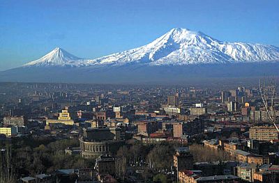
Mount Aragats, 4,090 meters (13,420 ft) high. Mount Ararat, the symbol of the country, 5,137 meters (16,854 ft) high, is today located in Turkish territory.
From the mountains, a down-slope wind, dry and warm, similar to the Föhn or Chinook, can reach the valleys, especially in winter, but also in spring and autumn.
 Precipitation
 in Armenia is not abundant, and generally increases with altitude, being scarce below 1,000 metres (3,300 ft), and moderate at higher altitudes. On the western plateau (see Yerevan, Vagharshapat), rainfall is scarce, in fact it ranges from 230 to 400 millimeters per year. In the north, on the other hand, above 1,400 metres (4,600 ft), rainfall is more abundant and can exceed 700 mm (27.5 in) per year.
Typically, the
driest period is from November to February, when precipitation occurs mostly in the form of snow. The
rainiest period goes from April to June, due to clashes between air masses, which can also cause thunderstorms.
The climate in detail
The seasons
Winter, from December to February, is very cold in much of Armenia. On the plateaus, the January average ranges from -3 °C (26.5 °F) in the lowest part (see
Yerevan) to -8 °C (17.5 °F) in the highest one, while in the high mountains, above 3,000 meters (9,800 ft), it drops below -10 °C (14 °F). Cold air tends to stagnate, bringing widespread frosts, and sometimes fog.
Snowfall is not abundant, however, due to the cold, snow can cover the ground for entire weeks, while the mountains are normally snow-capped. During cold spells, temperatures can drop below -20 °C (-4 °F), and even -30 °C (-22 °F) at high altitudes.
Only in the limited peripheral areas that are below 700 metres (2,300 ft), the winter is
relatively mild, so much so that the averages in January are 2/3 degrees Celsius above freezing (36/37 °F). In the north, in the province of Tavush, towards the border with Georgia and Azerbaijan, there are areas whose altitude ranges from 400 to 700 meters (1,300 to 2,300 ft), see Bagratashen, Ijevan). In the far south, in the province of Syunik, on the border with Iran, there are valleys that go down to 600/700 meters (2,000/,2300 ft) above sea level (see Kapan, Meghri).
Spring, from March to May, is an unstable season, and is the one that presents the most frequent rainfall, as well as the greatest risk of strong winds. May is typically the rainiest month.
The
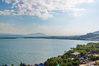
summer, from June to mid-September, is dry and sunny, with some afternoon thunderstorms, more likely in the north and in the mountains. Temperatures are more pleasant on the high altitude plateau and on Lake Sevan (see
Sevan), with days sometimes hot but cool nights, while on the western plateau, in Yerevan, it is very hot, especially in July and August, when the maximum temperatures are normally 34/35 °C (93/95 °F), and can sometimes reach 40 °C (104 °F).

In
autumn, from mid-September to late November, there is an increase in rainfall and the probability of unstable weather in October, although not as much as in spring. Temperatures gradually decrease.
When to go
If you want to visit Yerevan and the areas of Armenia below 1,000 meters (3,300 feet), which in summer can be very hot, the best times are
spring and autumn, especially the month of May and from mid-September to mid-October.
At higher altitudes, such as in Gyumri and Lake Sevan, you can choose instead the
summer, from June to September.
If you want to find a compromise for the whole country, you can choose June and September, or even July and August for those who can stand the heat.
What to pack
In
winter: bring very warm clothes, a fleece, a down jacket, a hat, a scarf, and gloves.
In
summer: in Yerevan, bring light clothes for the day, a sun hat, a sweatshirt and a light jacket for the evening. In Sevan and above 2,000 meters (6,500 feet), bring spring/autumn clothes, a sun hat, a sweater and a warm jacket for the evening, and possibly a raincoat or umbrella.
Climate data - Armenia
| Gyumri (1,500 meters) |
|---|
|
| Jan | Feb | Mar | Apr | May | Jun | Jul | Aug | Sep | Oct | Nov | Dec |
|---|
| Min temp. | -14 | -12 | -6 | 1 | 5 | 9 | 13 | 12 | 8 | 2 | -3 | -9 |
|---|
| Max temp. | -3 | -2 | 5 | 14 | 18 | 23 | 27 | 27 | 24 | 16 | 7 | 0 |
|---|
| Precip. | 20 | 30 | 25 | 45 | 80 | 65 | 45 | 35 | 20 | 40 | 35 | 20 |
|---|
| Prec. days | 6 | 6 | 6 | 9 | 14 | 11 | 7 | 6 | 4 | 6 | 7 | 5 |
|---|
|
|
| Sun hours | 3 | 4 | 5 | 5 | 7 | 10 | 11 | 10 | 9 | 6 | 5 | 3 |
|---|
|
| Sevan (2,000 meters) |
|---|
|
| Jan | Feb | Mar | Apr | May | Jun | Jul | Aug | Sep | Oct | Nov | Dec |
|---|
| Min temp. | -7 | -6 | -2 | 1 | 6 | 11 | 14 | 14 | 10 | 6 | 0 | -4 |
|---|
| Max temp. | -1 | 0 | 5 | 10 | 16 | 20 | 22 | 23 | 20 | 14 | 7 | 2 |
|---|
| Precip. | 15 | 25 | 35 | 60 | 85 | 80 | 45 | 35 | 25 | 50 | 30 | 20 |
|---|
| Prec. days | 8 | 9 | 10 | 12 | 14 | 13 | 8 | 6 | 6 | 8 | 8 | 7 |
|---|
|
|
| Sun hours | 5 | 6 | 6 | 7 | 8 | 10 | 11 | 10 | 9 | 7 | 6 | 5 |
|---|
|
| Yerevan (900 meters) |
|---|
|
| Jan | Feb | Mar | Apr | May | Jun | Jul | Aug | Sep | Oct | Nov | Dec |
|---|
| Min temp. | -8 | -5 | 1 | 7 | 11 | 15 | 19 | 19 | 14 | 7 | 0 | -5 |
|---|
| Max temp. | 1 | 6 | 14 | 20 | 25 | 31 | 34 | 34 | 30 | 22 | 13 | 4 |
|---|
| Precip. | 20 | 20 | 60 | 55 | 45 | 25 | 15 | 10 | 10 | 50 | 25 | 20 |
|---|
| Prec. days | 2 | 4 | 8 | 12 | 12 | 8 | 5 | 4 | 4 | 8 | 7 | 4 |
|---|
|
|
| Sun hours | 3 | 5 | 6 | 7 | 9 | 11 | 11 | 11 | 10 | 7 | 5 | 3 |
|---|
|
See also the
temperatures month by month