Select units of measurement for the temperature and rainfall tables (metric or imperial).
Average weather, temperature, rainfall, sunshine
In Bulgaria, a country of southeastern Europe that extends from 41 to 44 degrees north latitude, the climate is generally
continental, with cold winters and warm to hot summers; it is slightly milder along the coast of the Black Sea, and of course colder in hills and mountains.
Precipitation (rain or snow) is not abundant because the country is sheltered from the westerlies, which release most of the rainfall over the Adriatic coast, and usually ranges from 500 to 650 millimeters (20 to 25.5 inches) per year in the plains, while it is a bit more abundant in the mountains.
In winter, precipitation is not abundant in the lowlands, but it is quite frequent and often occurs in the form of snow. The rainiest months are May and June because of thunderstorms, which can occur in the afternoon. These heat tunderstorms are less frequent in coastal areas, while they are more frequent and abundant in mountainous areas. Typically, in August and September, it rarely rains, but even October is often a dry month, at least in the plains and in Sofia.
Bulgaria is a fairly
sunny country, although the sun does not shine very often in winter. The sunniest season is summer. Generally, there are 2,200/2,300 hours of sunshine per year, although the amount exceeds 2,600 hours in Sandanski, in the southwest, where there are several sunny days even in winter.
The climate in detail
The seasons
The country is exposed to both
cold air masses from northern Europe or Russia and
warm air masses from Northern Africa or the Mediterranean. In the south, at the border with Greece, the Rhodope Mountains, which somewhat separate Bulgaria from the Mediterranean world, are able to partly block the southern currents, however, warm air masses can at times surpass them and invade the country, bringing mild periods in winter and very hot in summer.
As a result, Bulgaria can experience
cold waves in winter (generally, from mid-November to mid-March, but especially from December to February) and
heat waves in summer (generally, from mid-June to mid-September, but especially in July and August).
The clash between air masses can bring
strong winds, especially in the mountains and in the Thracian Plain, which lies south of the Balkan range.
Winter, from December to February, is cold throughout the country. Cold air often stagnates on the plains, with cloudy skies and light snowfalls, but these stable periods may be interrupted by warm wind invasions from the south, which can raise the temperature to 15 °C (59 °F) and more, and more frequently, by of cold air outbreaks from Russia, which can bring strong winds followed by severe frosts.
Spring, from March to May, is not very rainy; however, because of the clash between different air masses, it experiences great changes in temperature, especially in March and April, when the first warm days alternate with characterized by cold weather coming back, during which some late snow showers can occur. Usually, from mid-April or May, temperatures in the plains begin to be mild or warm in a more stable way. By May, in fine weather, afternoon thunderstorms begin to occur.
 Summer
, from June to August, is warm, or even hot, especially in inland plains: the heat is intense in the lowlands, especially at a distance from the sea. Highs are normally around 30/32 °C (86/90 °F), but very hot days, with peaks of 40 °C (104 °F), are not so rare.
Heatwaves are more frequent in July and August, but can sometimes also occur in the second half of June and in the first half of September.
In coastal areas, the heat is less intense and tempered by the breeze.
Autumn, from September to November, starts as a mild and pleasant season, with rare rains. Actually, in the first half of September there can still be summer-like weather. When the first rains occur in the central-western Mediterranean, high pressures systems still resist here. In general, there is a fairly sharp turn during the month of October, when colder air masses begin to circulate, but the rains are certainly not as plentiful as on the Mediterranean coast of the Balkan Peninsula, since the country is not directly exposed to western or southern winds.
Inland areas
In Bulgaria, there are two plains, divided by the chain of the Balkan Mountains (or
Stara Planina), which is stretched from west to east.
North of the mountains, in the
Danube Plain, separated from Romania by the river of the same name, where cities like
Ruse and
Pleven are found, the average temperature ranges from around 0 °C (32 °F) in January to 24/25 °C (75/77 °F) in July.
South of the Balkans, the
Thracian Plain, crossed by the Maritsa River, where cities like Plovdiv and Stara Zagora are found, is slightly warmer.
The Danube Plain is more exposed to cold waves because the Balkans partly block the northern winds, in fact, the cold records of the past 20 years are around -25 °C (-13 °F) in the Danube Plain, while they hover around -20 °C (-4 °F) in the Thracian Plain.
In summer, both plains can be affected by heat waves, with temperatures of 40 °C (104 °F) and above.
Plovdiv
In
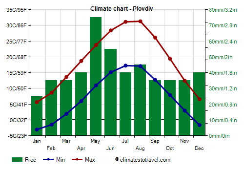
Plovdiv, situated, as mentioned, in the southern plain (Thracian plain, the average temperature ranges from 1.5 °C (34.5 °F) in January and February to 24 °C (75 °F) in July and August.
Plovdiv is located in one of the driest areas of the country, and receives 500 mm (20 in) of rain (or snow) per year.
In the south-west, in the valley of the Struma River, towards the border with Greece (see
Kyustendil, Blagoevgrad,
Sandanski), the climate is a bit milder than in the plains: winters are quite cold, with possible frosts, while summers are hot.
Sofia
The capital,
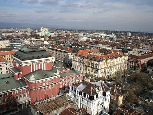
Sofia, is located at 550 meters (1,800 ft) of altitude, in a valley, a position that enhances cold air stagnation in winter and, in some cases, the summer heat as well.
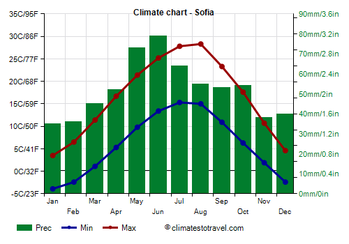
The city is located south of the western part of the Balkan range, but in this part, the mountains are not very high, so they don't protect much the city from cold air masses; in addition, because of the altitude, the city is often the coldest city of Bulgaria. Here, the average in January is 0 °C (32 °F).
In summer, however, Sofia is cooler than the plains because of altitude: the average temperature in July is 21.5 °C (70.5 °F), even though it can sometimes be hot, with peaks of 35/37 °C (95/99 °F) from June to August, while nights are almost always cool and pleasant.
In Sofia, the rains are a bit more abundant than in Plovdiv, and amount to 625 mm (24.5 in) per year.
Mountains
In addition to the aforementioned Balkan chain in the north, whose highest peak is Mount
Botev, 2,376 meters (7,795 ft) high, we find Mount Vitosha near Sofia, and then in the south, south of the Thracian plain, the Rila and Pirin massifs and the Rhodope mountains.
The mountainous areas have a cold climate, and the temperatures are similar, at a given altitude, to those of the southern side of the Alps. You can go skiing until the end of March in Borovets and Pamporovo.
Precipitation is more abundant than in the plains.
Murgash
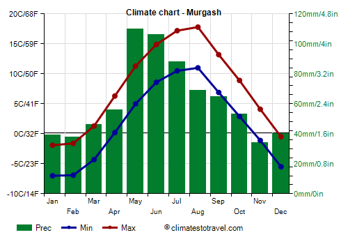
On
Murgash peak, located north-east of Sofia and belonging to the Balkan mountains, at 1,685 meters (5,528 ft) above sea level, the average temperature ranges from -4.5 °C (24 °F) in January to 14.5 °C (58 °F) in August.
Precipitation amounts to 740 mm (29 in) per year.
Musala
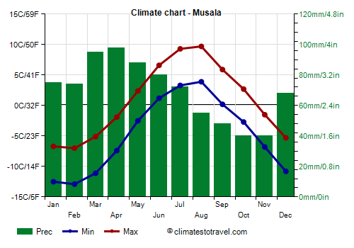
On
Musala, which is located in the Rila Massif and is the highest peak in the whole of Bulgaria, at 2,925 meters (9,596 feet), fog, snow and strong winds are frequent. The temperature generally drops below -20 °C (-4 °F) every year. In March 1987, it dropped to -29 °C (-20 °F), and in January 1979, to -31 °C (-24 °F).
In summer, fog often forms. Sometimes it can snow even in the middle of summer. In mild periods, however, the temperature can exceed 15 °C (59 °F). In July 2007 it reached 20 °C (68 °F).
Precipitation amounts to 835 mm (32.5 in) per year.
The coast
To the east, the climate in the coastal strip, where we find cities like
Varna,
Sunny Beach, and Burgas, is
milder than in the inland plain, being influenced by the Black Sea. In summer, sea breezes blow.
However, the coast can also be affected by cold waves in winter, with peaks of -15 °C (5 °F) or less, and by heat waves in summer, with peaks of 36/38 °C (97/100 °F) or more.
Burgas
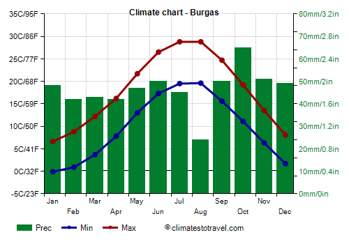
In
Burgas, located in the northern part of the coast, the average temperature ranges from 3.3 °C (38 °F) in January to 24 °C (75 °F) in July and August.
Even on the coast, rainfall is not abundant, and generally ranges from 550 to 600 mm (21.5 to 23.5 in) per year.
The Black Sea is acceptable for swimming in summer, especially in July and August, when it reaches 24/24.5 °C (75/76 °F), while it's still a little cool in June.
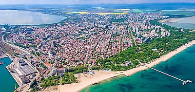
In the south-eastern part of Bulgaria, south of Burgas and towards the Turkish border (see
Ahtopol), the climate becomes even milder.
When to go
Having a continental climate, Bulgaria can be visited in
spring and autumn, in particular, from mid-May to mid-June, a period when some afternoon thunderstorms must be put into account, and from mid-September to mid-October, a period a bit cooler but also drier.
For those who can stand the heat,
summer can also be good, remembering that the cities located in inland plains like Plovdiv and Pleven can be hot in July and August.
In Sofia, the summer heat is slightly cooled by altitude. From May to August, some afternoon thunderstorms can occur, which become gradually less frequent, in fact, there are 9 days with some rainfall in May, 8 in June, 7 in July and 6 in August. In July and August, however, it can sometimes get hot during the day. In September, there are on average only 4 days with rain, and the temperatures are pleasant.
The
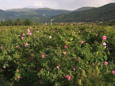
Rose Valley, from Karlovo to Kazanlak, is located at about 400 meters (1,300 feet) above sea level, south of the Balkan Mountains, and in the flowering period, from mid-May to mid-June, it has warm days and cool nights, with possible thunderstorms in the afternoon.
The coastal areas of Bulgaria can be a pleasant place to stay in summer (July and August) for a
beach holiday. Every so often, some showers or thunderstorms can occur in the afternoon, but more rarely than in inland areas. September is still nice and sunny.
What to pack
In
winter: bring warm clothes, such as a sweater, a down jacket, a hat, gloves, a scarf, and a raincoat or umbrella.
In
summer: bring light clothes, a T-shirt, but also long pants, a light jacket and a sweatshirt for the evening, and an umbrella.
Climate data - Bulgaria
| Ahtopol |
|---|
|
| Jan | Feb | Mar | Apr | May | Jun | Jul | Aug | Sep | Oct | Nov | Dec |
|---|
| Min temp. | 0 | 0 | 3 | 7 | 12 | 16 | 18 | 17 | 15 | 12 | 6 | 2 |
|---|
| Max temp. | 6 | 8 | 11 | 16 | 21 | 26 | 28 | 27 | 24 | 19 | 14 | 9 |
|---|
| Precip. | 50 | 45 | 40 | 45 | 45 | 45 | 35 | 30 | 45 | 50 | 75 | 60 |
|---|
| Prec. days | 9 | 8 | 7 | 4 | 4 | 5 | 3 | 3 | 5 | 7 | 5 | 9 |
|---|
|
|
| Sun hours | 3 | 4 | 5 | 7 | 8 | 9 | 10 | 9 | 8 | 6 | 3 | 2 |
|---|
| Sea temp | 8 | 8 | 8 | 10 | 16 | 21 | 24 | 25 | 22 | 18 | 14 | 11 |
|---|
| Burgas |
|---|
|
| Jan | Feb | Mar | Apr | May | Jun | Jul | Aug | Sep | Oct | Nov | Dec |
|---|
| Min temp. | 0 | 1 | 4 | 8 | 13 | 17 | 20 | 20 | 16 | 11 | 6 | 2 |
|---|
| Max temp. | 7 | 9 | 12 | 16 | 22 | 26 | 29 | 29 | 25 | 19 | 14 | 8 |
|---|
| Precip. | 50 | 40 | 45 | 40 | 45 | 50 | 45 | 25 | 50 | 65 | 50 | 50 |
|---|
| Prec. days | 6 | 5 | 7 | 6 | 7 | 6 | 5 | 3 | 5 | 6 | 5 | 7 |
|---|
| Humidity | 82% | 78% | 76% | 75% | 75% | 71% | 68% | 67% | 70% | 77% | 81% | 82% |
|---|
| Day length | 10 | 11 | 12 | 13 | 15 | 15 | 15 | 14 | 12 | 11 | 10 | 9 |
|---|
| Sun hours | 2 | 3 | 4 | 6 | 8 | 9 | 11 | 10 | 8 | 5 | 3 | 2 |
|---|
| Sea temp | 8 | 8 | 8 | 10 | 16 | 21 | 24 | 25 | 22 | 18 | 14 | 11 |
|---|
| Kyustendil (560 meters) |
|---|
|
| Jan | Feb | Mar | Apr | May | Jun | Jul | Aug | Sep | Oct | Nov | Dec |
|---|
| Min temp. | -5 | -4 | 0 | 4 | 9 | 12 | 14 | 14 | 9 | 5 | 0 | -3 |
|---|
| Max temp. | 5 | 8 | 13 | 18 | 23 | 27 | 30 | 30 | 25 | 19 | 12 | 5 |
|---|
| Precip. | 35 | 40 | 45 | 50 | 60 | 70 | 60 | 45 | 45 | 55 | 50 | 55 |
|---|
| Prec. days | 6 | 6 | 6 | 7 | 9 | 8 | 6 | 6 | 6 | 6 | 6 | 8 |
|---|
| Humidity | 79% | 77% | 71% | 65% | 67% | 67% | 63% | 62% | 64% | 71% | 78% | 81% |
|---|
| Day length | 10 | 11 | 12 | 13 | 15 | 15 | 15 | 14 | 12 | 11 | 10 | 9 |
|---|
| Sun hours | 3 | 4 | 5 | 6 | 7 | 9 | 10 | 10 | 7 | 5 | 3 | 2 |
|---|
|
| Murgash (1,685 meters) |
|---|
|
| Jan | Feb | Mar | Apr | May | Jun | Jul | Aug | Sep | Oct | Nov | Dec |
|---|
| Min temp. | -7 | -7 | -4 | 0 | 5 | 9 | 10 | 11 | 7 | 3 | -1 | -6 |
|---|
| Max temp. | -2 | -2 | 1 | 6 | 11 | 15 | 17 | 18 | 13 | 9 | 4 | 0 |
|---|
| Precip. | 40 | 40 | 45 | 55 | 110 | 105 | 90 | 70 | 65 | 55 | 35 | 40 |
|---|
| Prec. days | 9 | 9 | 9 | 9 | 12 | 10 | 8 | 6 | 7 | 6 | 7 | 9 |
|---|
|
|
| Sun hours | 3 | 3 | 4 | 5 | 6 | 8 | 9 | 9 | 7 | 5 | 4 | 3 |
|---|
|
| Musala (2,925 meters) |
|---|
|
| Jan | Feb | Mar | Apr | May | Jun | Jul | Aug | Sep | Oct | Nov | Dec |
|---|
| Min temp. | -12 | -13 | -11 | -7 | -2 | 1 | 3 | 4 | 0 | -3 | -7 | -11 |
|---|
| Max temp. | -7 | -7 | -5 | -2 | 2 | 7 | 9 | 10 | 6 | 3 | -2 | -5 |
|---|
| Precip. | 75 | 75 | 95 | 100 | 90 | 80 | 70 | 55 | 50 | 40 | 40 | 70 |
|---|
| Prec. days | 11 | 11 | 13 | 13 | 13 | 12 | 10 | 7 | 7 | 7 | 8 | 11 |
|---|
|
|
| Sun hours | 4 | 4 | 5 | 4 | 5 | 6 | 7 | 8 | 6 | 5 | 4 | 3 |
|---|
|
| Plovdiv |
|---|
|
| Jan | Feb | Mar | Apr | May | Jun | Jul | Aug | Sep | Oct | Nov | Dec |
|---|
| Min temp. | -3 | -1 | 2 | 6 | 11 | 15 | 17 | 17 | 13 | 8 | 3 | -2 |
|---|
| Max temp. | 6 | 9 | 14 | 19 | 24 | 28 | 31 | 31 | 26 | 19 | 12 | 7 |
|---|
| Precip. | 25 | 35 | 35 | 40 | 75 | 55 | 40 | 45 | 35 | 35 | 35 | 40 |
|---|
| Prec. days | 5 | 5 | 6 | 5 | 6 | 6 | 4 | 3 | 3 | 4 | 6 | 6 |
|---|
| Humidity | 81% | 74% | 67% | 65% | 66% | 62% | 55% | 54% | 60% | 72% | 79% | 82% |
|---|
| Day length | 10 | 11 | 12 | 13 | 15 | 15 | 15 | 14 | 12 | 11 | 10 | 9 |
|---|
| Sun hours | 3 | 4 | 5 | 7 | 8 | 9 | 11 | 10 | 8 | 5 | 4 | 2 |
|---|
|
| Ruse |
|---|
|
| Jan | Feb | Mar | Apr | May | Jun | Jul | Aug | Sep | Oct | Nov | Dec |
|---|
| Min temp. | -3 | -2 | 3 | 8 | 13 | 17 | 19 | 18 | 14 | 8 | 3 | -2 |
|---|
| Max temp. | 4 | 7 | 14 | 19 | 25 | 29 | 32 | 32 | 26 | 19 | 11 | 5 |
|---|
| Precip. | 30 | 30 | 45 | 45 | 65 | 70 | 75 | 50 | 65 | 55 | 50 | 45 |
|---|
| Prec. days | 6 | 4 | 6 | 7 | 8 | 7 | 7 | 5 | 6 | 6 | 7 | 7 |
|---|
| Humidity | 85% | 78% | 67% | 63% | 64% | 63% | 60% | 59% | 64% | 74% | 80% | 86% |
|---|
| Day length | 9 | 10 | 12 | 14 | 15 | 15 | 15 | 14 | 12 | 11 | 10 | 9 |
|---|
| Sun hours | 3 | 4 | 5 | 7 | 9 | 10 | 10 | 10 | 8 | 5 | 4 | 2 |
|---|
|
| Sandanski |
|---|
|
| Jan | Feb | Mar | Apr | May | Jun | Jul | Aug | Sep | Oct | Nov | Dec |
|---|
| Min temp. | -1 | 1 | 4 | 8 | 13 | 17 | 19 | 19 | 15 | 10 | 5 | 1 |
|---|
| Max temp. | 8 | 11 | 15 | 20 | 26 | 30 | 33 | 34 | 28 | 21 | 14 | 9 |
|---|
| Precip. | 40 | 35 | 45 | 45 | 50 | 50 | 40 | 30 | 40 | 55 | 45 | 55 |
|---|
| Prec. days | 6 | 6 | 7 | 6 | 8 | 6 | 5 | 3 | 5 | 5 | 6 | 8 |
|---|
| Humidity | 76% | 73% | 68% | 63% | 63% | 60% | 56% | 56% | 60% | 68% | 76% | 79% |
|---|
| Day length | 10 | 11 | 12 | 13 | 15 | 15 | 15 | 14 | 12 | 11 | 10 | 9 |
|---|
| Sun hours | 4 | 5 | 6 | 7 | 9 | 10 | 11 | 11 | 8 | 6 | 4 | 4 |
|---|
|
| Sliven (250 meters) |
|---|
|
| Jan | Feb | Mar | Apr | May | Jun | Jul | Aug | Sep | Oct | Nov | Dec |
|---|
| Min temp. | -1 | 0 | 3 | 7 | 12 | 16 | 19 | 19 | 14 | 10 | 5 | 0 |
|---|
| Max temp. | 6 | 8 | 12 | 18 | 23 | 27 | 30 | 30 | 25 | 19 | 13 | 7 |
|---|
| Precip. | 45 | 45 | 40 | 40 | 65 | 70 | 50 | 40 | 65 | 50 | 50 | 55 |
|---|
| Prec. days | 6 | 5 | 7 | 7 | 9 | 7 | 6 | 4 | 5 | 5 | 5 | 6 |
|---|
| Humidity | 82% | 81% | 76% | 71% | 70% | 67% | 64% | 64% | 67% | 73% | 80% | 83% |
|---|
| Day length | 10 | 11 | 12 | 13 | 15 | 15 | 15 | 14 | 12 | 11 | 10 | 9 |
|---|
| Sun hours | 3 | 4 | 5 | 7 | 8 | 10 | 10 | 10 | 8 | 6 | 4 | 3 |
|---|
|
| Sofia (550 meters) |
|---|
|
| Jan | Feb | Mar | Apr | May | Jun | Jul | Aug | Sep | Oct | Nov | Dec |
|---|
| Min temp. | -4 | -2 | 1 | 5 | 10 | 13 | 15 | 15 | 11 | 6 | 2 | -2 |
|---|
| Max temp. | 4 | 6 | 11 | 17 | 21 | 25 | 28 | 28 | 23 | 18 | 11 | 5 |
|---|
| Precip. | 35 | 35 | 45 | 50 | 75 | 80 | 65 | 55 | 55 | 55 | 40 | 40 |
|---|
| Prec. days | 6 | 6 | 7 | 8 | 10 | 9 | 7 | 6 | 6 | 6 | 6 | 7 |
|---|
| Humidity | 84% | 76% | 67% | 63% | 67% | 67% | 61% | 59% | 64% | 73% | 80% | 84% |
|---|
| Day length | 10 | 11 | 12 | 13 | 15 | 15 | 15 | 14 | 12 | 11 | 10 | 9 |
|---|
| Sun hours | 3 | 4 | 5 | 7 | 8 | 9 | 10 | 10 | 8 | 5 | 4 | 2 |
|---|
|
| Varna |
|---|
|
| Jan | Feb | Mar | Apr | May | Jun | Jul | Aug | Sep | Oct | Nov | Dec |
|---|
| Min temp. | -3 | -2 | 1 | 5 | 10 | 15 | 17 | 17 | 13 | 8 | 5 | 0 |
|---|
| Max temp. | 7 | 7 | 12 | 17 | 22 | 27 | 30 | 30 | 25 | 19 | 14 | 9 |
|---|
| Precip. | 50 | 35 | 50 | 40 | 40 | 50 | 50 | 30 | 55 | 60 | 55 | 50 |
|---|
| Prec. days | 6 | 5 | 7 | 6 | 7 | 6 | 5 | 3 | 6 | 6 | 6 | 7 |
|---|
| Humidity | 81% | 77% | 74% | 72% | 74% | 72% | 68% | 67% | 72% | 79% | 81% | 82% |
|---|
| Day length | 9 | 11 | 12 | 14 | 15 | 15 | 15 | 14 | 12 | 11 | 10 | 9 |
|---|
| Sun hours | 3 | 4 | 5 | 6 | 8 | 9 | 10 | 10 | 8 | 5 | 4 | 3 |
|---|
| Sea temp | 8 | 7 | 8 | 10 | 15 | 21 | 24 | 25 | 22 | 18 | 14 | 10 |
|---|
| Veliko Tarnovo (220 meters) |
|---|
|
| Jan | Feb | Mar | Apr | May | Jun | Jul | Aug | Sep | Oct | Nov | Dec |
|---|
| Min temp. | -4 | -4 | 2 | 6 | 11 | 16 | 17 | 17 | 12 | 8 | 3 | -2 |
|---|
| Max temp. | 6 | 7 | 14 | 20 | 25 | 29 | 31 | 32 | 26 | 20 | 14 | 8 |
|---|
| Precip. | 45 | 40 | 40 | 50 | 70 | 75 | 55 | 40 | 40 | 40 | 55 | 55 |
|---|
| Prec. days | 9 | 8 | 8 | 9 | 10 | 10 | 7 | 6 | 5 | 5 | 8 | 9 |
|---|
|
|
| Sun hours | 3 | 4 | 5 | 7 | 8 | 10 | 10 | 10 | 8 | 6 | 4 | 3 |
|---|
|
| Vidin |
|---|
|
| Jan | Feb | Mar | Apr | May | Jun | Jul | Aug | Sep | Oct | Nov | Dec |
|---|
| Min temp. | -4 | -3 | 1 | 6 | 11 | 15 | 16 | 16 | 11 | 7 | 2 | -3 |
|---|
| Max temp. | 4 | 7 | 13 | 19 | 25 | 29 | 31 | 31 | 24 | 18 | 10 | 4 |
|---|
| Precip. | 35 | 30 | 30 | 50 | 50 | 50 | 60 | 55 | 50 | 50 | 50 | 50 |
|---|
| Prec. days | 6 | 5 | 5 | 8 | 7 | 6 | 6 | 5 | 6 | 7 | 8 | 8 |
|---|
| Humidity | 82% | 80% | 74% | 69% | 71% | 72% | 69% | 69% | 72% | 77% | 81% | 83% |
|---|
| Day length | 9 | 10 | 12 | 14 | 15 | 15 | 15 | 14 | 12 | 11 | 10 | 9 |
|---|
| Sun hours | 2 | 4 | 6 | 7 | 8 | 10 | 10 | 10 | 7 | 5 | 3 | 2 |
|---|
|
See also the
temperatures month by month