Select units of measurement for the temperature and rainfall tables (metric or imperial).
Average weather, temperature, rainfall, sunshine hours
The climate of Cappadocia is
continental, with cold winters, during which the average temperature is close to freezing, and hot summers during the day, but with cool nights.
The region is located in the central part of Turkey, in the Anatolian plateau. The largest cities are Kayseri (or Caesarea of Cappadocia), located at 1,050 meters (3,445 feet) above sea level, and Nevşehir (or Nissa), located at 1,200 meters (3,935 ft), near Göreme.
The
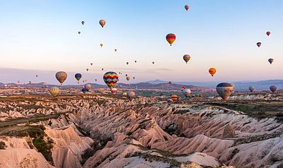
Göreme National Park, where the famous Fairy Chimneys are found, is located at an altitude between 1,000 and 1,300 metres (3,300 and 4,300 ft). The hot air balloon flights depart near Çavuşin, in the Rose Valley, at around 1,000 metres (3,300 ft).
Outside the park there are two volcanoes, to the south of Kayseri is Mount Erciyes (or Argaeus), 3,916 meters (12,848 ft) high, while further south-west is Mount Hasan, 3,253 meters (10,672 ft) high.

Average
temperatures are close to freezing in winter, and 22 °C (71.5 °F) in summer. Here are the average temperatures in
Kayseri.
Kayseri - Average temperatures (1991-2020) |
| Month | Min | Max | Mean |
|---|
| January | -5.4 | 4.6 | -0.4 |
|---|
| February | -4.5 | 6.6 | 1 |
|---|
| March | -0.1 | 12.2 | 6 |
|---|
| April | 3.9 | 17.9 | 10.9 |
|---|
| May | 7.6 | 22.7 | 15.2 |
|---|
| June | 11 | 27.4 | 19.2 |
|---|
| July | 13.5 | 31.3 | 22.4 |
|---|
| August | 13.3 | 31.4 | 22.4 |
|---|
| September | 9 | 27.1 | 18 |
|---|
| October | 4.9 | 20.8 | 12.8 |
|---|
| November | -0.5 | 12.9 | 6.2 |
|---|
| December | -3.6 | 6.5 | 1.4 |
|---|
| Year | 4.1 | 18.5 | 11.3 |
|---|
is not abundant, in fact it amounts to around 400 millimeters (15.5 inches) per year. The rainiest season is spring, the driest is summer, when rare thunderstorms occur. Here is the average rainfall in Kayseri.
Kayseri - Average precipitation| Month | Days |
|---|
| January | 40 | 9 |
|---|
| February | 40 | 11 |
|---|
| March | 50 | 13 |
|---|
| April | 45 | 14 |
|---|
| May | 60 | 14 |
|---|
| June | 40 | 10 |
|---|
| July | 12 | 2 |
|---|
| August | 10 | 2 |
|---|
| September | 14 | 5 |
|---|
| October | 30 | 7 |
|---|
| November | 30 | 8 |
|---|
| December | 40 | 10 |
|---|
| Year | 410 | 106 |
|---|
The
sun shines regularly in summer, while in winter it does not shine very often. Here are average sunshine hours per year in Kayseri.
Kayseri - Sunshine hours| Month | Average | Total |
|---|
| January | 3 | 90 |
|---|
| February | 4 | 115 |
|---|
| March | 4.5 | 145 |
|---|
| April | 6 | 185 |
|---|
| May | 8 | 250 |
|---|
| June | 10 | 300 |
|---|
| July | 11.5 | 355 |
|---|
| August | 11 | 340 |
|---|
| September | 8.5 | 255 |
|---|
| October | 6.5 | 195 |
|---|
| November | 4.5 | 140 |
|---|
| December | 2.5 | 85 |
|---|
| Year | 6.7 | 2455 |
|---|
In
winter, snowfalls are quite frequent. Furthermore, there may be cold waves of Russian origin, during which the temperature can drop to around -20 °C (-4 °F). In February 1991, it dropped to -27 °C (-16.5 °F) in Kayseri.
In
summer, there is a remarkable temperature difference between night and day. In some periods, it can get very hot during the day, with highs of 35 °C (95 °F) or more. In August 2023, the temperature reached 41 °C (106 °F) in Kayseri and 38 °C (100 °F) in Nevşehir, located, as mentioned, at a slightly higher altitude.