Select units of measurement for the temperature and rainfall tables (metric or imperial).
Average weather, temperature, rainfall, sunshine
In Algeria, the largest African country, there are three types of climate: the
Mediterranean climate of the coast, the transitional climate of the northern hills and mountains, which is a little more continental and moderately rainy, and finally, the
desert climate of the vast area occupied by the Sahara.
Index
The coast
In the thin
coastal strip (zone 1 on the map), the climate is typically Mediterranean, with mild, rainy winters and hot, sunny summers.
The rains are scarcer in the western part (see
Oran), where they range between 330 and 400 millimeters (13 and 16 inches) per year; consequently, the landscape here is more arid. In the central and eastern parts (see Algiers,
Annaba), the rains are more abundant, in fact they range between 600 and 800 mm (23.5 and 31.5 in). Most of the rains occur between October and April.
By contrast, the temperatures on the coast are rather uniform: the daily average is around 11/12 °C (52/53.5 °F) in January and around 26/27 °C (79/81 °F) in August (which is, albeit slightly, the warmest month). Summer is sunny, with fairly high humidity, but also with the breeze blowing from the sea.
Sometimes, a hot wind coming from the desert, called
Chili, can blow: it reaches the coast after climbing the mountains, and it is able to cause a sudden drop in relative humidity and to bring sand and dust. This wind is more frequent in spring and autumn; when it blows in summer, it can raise temperatures above 40 °C (104 °F), and occasionally up to 47/48 °C (117/118 °F).
Algiers
 Algiers
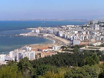
, the capital, is located in the central part of the coast.
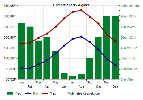
Precipitation totals 600 mm (23.5 in) per year. The trend is typically Mediterranean, in fact the rainiest period goes from November to January, while in summer it rains very rarely.
Along the coast, the
sun shines regularly in summer, while in the other seasons, there may be sunny days, but also cloudy and rainy days.
The
sea is warm enough for swimming from July to September, while in June, it's still a bit cool.
In the eastern part of the coast (see Annaba), the sea is a bit warmer than in the western part (see Oran), which is located near the Alborán Sea, where the Mediterranean water mixes with the Atlantic water.
Mountainous areas
In the north of Algeria, we find a
mountainous belt parallel to the coast (zone 2), which divides it from the desert. There are two mountain ranges, Tell Atlas and Saharan Atlas; the former is wetter because it's more often affected by humid winds from the sea, and in winter it's snowy, so much so that there are a few winter resorts (see Chréa, Tikjda) where you can go skiing, especially from December to March.
Between the two ranges, we find a
plateau, with several cities located between 1,000 and 1,300 meters (3,300 and 4,200 feet). Here, the climate is
slightly continental, with quite cold winters and hot summers.
Sétif
For example, in
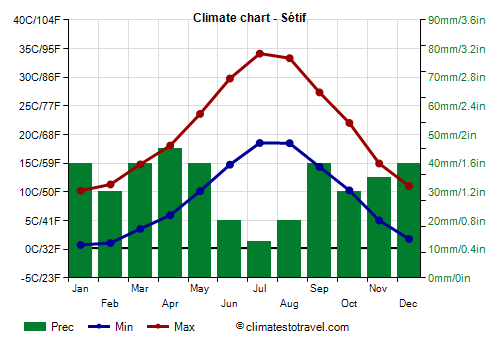
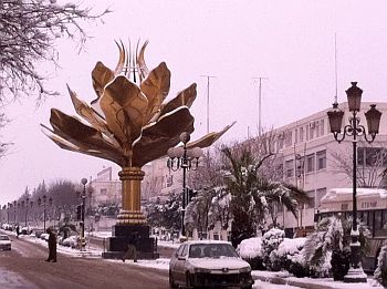
Sétif, at 1,000 meters (3,300 feet) above sea level, the daily average ranges from 5.5 °C (42 °F) in January to 26.5 °C (79 °F) in July. So, the summer here is as hot as on the coast, but the humidity is lower, in addition, the temperature is higher during the day and lower at night. Winter is rather cold, especially when cold air masses arrive from Europe, which can at times bring even snow and frost.
In Sétif, precipitation amounts to 400 mm (16 in) per year and follows the Mediterranean pattern, ie with a maximum in winter and a minimum in summer, when, however, some rare thunderstorms are possible.
A similar climate is found in other towns of the area, with a few variations due to altitude and slope exposure, such as
Batna, 1,000 meters (3,300 feet) above sea level,
Constantine, 770 meters (2,500 feet), and
Tebessa, 800 meters (2,600 feet).
Saharan Desert
In the vast Algerian desert (zone 3), the climate is
hot and dry during the long summer months, and it's also progressively hotter and drier as you proceed towards the south.
In winter, the warmest area is the far south, where the temperature during the day is around 25/27 °C (77/80 °F), while the hottest area in summer lies between the 24th and the 30th parallel, since the far south is reached by the extreme offshoot of the African monsoon, which bring a bit of cloudiness and occasional downpours.
The
rains are very rare in the whole area, below 100 mm (4 in) per year, and often below 50 mm (2 in); they occur in the form of downpours, and are more likely in winter in the north, and as mentioned, in summer in the far south.
The sky in the desert is almost always clear, and this favors a wide
temperature range between night and day, which is often around 20 degrees Celsius (35 degrees Fahrenheit). During winter, the temperature can drop below freezing at night, albeit slightly, while the days remain mild.
In the desert,
sand storms can occur at any time, especially in the vast areas covered with sand dunes, called
ergs.
The
heat records, which are set during hot air invasions from the south, depend on the position and altitude, and range from 48 °C (118 °F) in the northernmost part (see Biskra) to 50/51 °C (122/124 °F) in the hottest areas.
Biskra
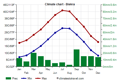
In the northern part of the desert, the average maximum temperature in July and August is around 40/41 °C (104/106 °F) in
Biskra, the "Gateway of the Sahara", located just south of the Saharan Atlas, and around 41/42 °C (106/108 °F) in
Touggourt.
In Biskra, rainfall amounts to 155 mm (6.1 in) per year.
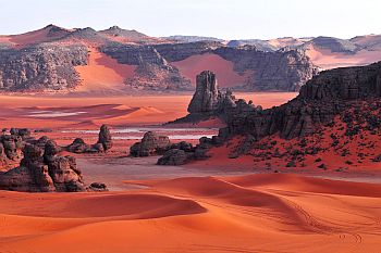
In the south-east of the country, in the middle of the desert, there is a mountain massif, called
Hoggar, whose highest peak is Mount Tahat, 2,908 meters (9,541 feet) high. Here, the rains, still at desert-like levels, are slightly more frequent than in the surrounding areas. North of Hoggar, but still in a mountainous region, we find the
Tassili N'Ajjer National Park, a rocky desert, with deep canyons and lunar landscapes, but also some verdant oasis.
Tamanrasset
The city of
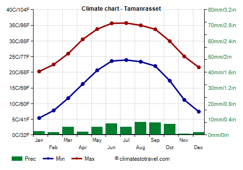
Tamanrasset, 1,400 meters (4,600 feet) above sea level, has a very salubrious climate, dry and sunny all year round, and tempered by the altitude: in winter, it can get cold at night, while the days remain mild, whereas in summer, the heat is intense, but not as intense as at sea level, in fact, average highs are around 35/36 °C (95/97 °F), with possible peaks around 40/42 °C (104/108 °F).
Rainfall in Tamanrasset, rare and sporadic, is slightly above 50 mm (2 in) per year. In the lowlands of this southern part of the desert, rainfall is even scarcer.
The situation is quite different in the lowlands of the central-southern part of the desert. In oases like
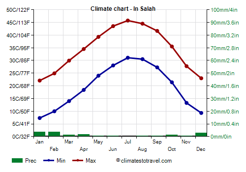
Timimoun, In Salah, Aoulef and Reggane, the average maximum in July is around 45/46 °C (113/115 °F), and the highest records are around 50/51 °C (122/124 °F). In summer, this is one of the hottest regions in the world.
In Salah
 In Salah
 is an oasis located in the center of the country, in the province of Tamanrasset, at 290 meters (950 feet) of altitude.
In In Salah, the sun shines all year round.
Owing to the aforementioned marginal influence of the African monsoon, the amount of sunshine in summer slightly decreases in the south and in the Hoggar Massif (where there are 10 hours of sunshine per day, compared with 12 hours in the central and northern regions).
When to go
The best time to visit
Algiers and the coastal cities, but also those of the mountainous belt, is spring, and in particular the months of April and May. Autumn is also a good season, especially the month of October, which, however, is more rainy. You can then choose September, which, however, can still be hot during the day.
If you want to visit the
Algerian desert, the best season is winter, from December to February, especially in the southern part: it is true that at night it is cold, but during the day the sun shines and the temperature is pleasant. In the northern part of the desert (see Biskra), which in winter is more often cold, you may prefer the months of March and November.
You can go to the
beach from mid-May to October, although, as we mentioned, the sea becomes warm enough for swimming in July, and given that the rains may start by October, the best time for a beach holiday runs from July to September.
What to pack in the suitcase
In
winter: for Algiers and the coast, bring spring/autumn clothes, a jacket and a sweater, and a raincoat or umbrella. For the hilly and mountainous areas of the north, bring warm clothes, such as a down jacket, and a hat. For the desert, spring/autumn clothes, being ready to remove the outer layer during the day, but a also sweater and a warm jacket for the evening and early morning, and a scarf for the sand.
In
summer: for Algiers and the coast, and the northern plateau as well, bring summer clothing, a light sweatshirt for the evening, and possibly a scarf for the wind-borne sand and dust. For the desert, loose-fitting, light-colored clothing, light and long shirts and pants of natural fibers (cotton, linen), a wide-brimmed hat, a light scarf, sunglasses (even graduated instead of contact lenses), comfortable and breathable shoes. For the mountains or for nights in a tent, you can bring a sweatshirt for the evening, and hiking boots or sandals.
It's better for women to avoid shorts and miniskirts, especially in rural and non-tourist areas.
Climate data - Algeria
| Algiers |
|---|
Algiers, location on the map |
|---|
| Jan | Feb | Mar | Apr | May | Jun | Jul | Aug | Sep | Oct | Nov | Dec |
|---|
| Min temp. | 5 | 5 | 7 | 9 | 12 | 16 | 19 | 20 | 18 | 14 | 10 | 7 |
|---|
| Max temp. | 17 | 17 | 20 | 22 | 25 | 29 | 32 | 33 | 30 | 27 | 21 | 18 |
|---|
| Precip. | 80 | 75 | 55 | 60 | 40 | 10 | 5 | 10 | 30 | 60 | 90 | 90 |
|---|
| Prec. days | 11 | 10 | 9 | 11 | 7 | 3 | 2 | 3 | 5 | 9 | 11 | 12 |
|---|
| Humidity | 77% | 76% | 75% | 74% | 72% | 68% | 67% | 67% | 70% | 72% | 76% | 78% |
|---|
| Day length | 10 | 11 | 12 | 13 | 14 | 15 | 14 | 14 | 12 | 11 | 10 | 10 |
|---|
| Sun hours | 4 | 6 | 7 | 8 | 10 | 10 | 11 | 10 | 9 | 6 | 5 | 5 |
|---|
| Sea temp | 16 | 15 | 15 | 16 | 18 | 21 | 24 | 26 | 25 | 22 | 19 | 17 |
|---|
| Annaba |
|---|
Annaba, location on the map |
|---|
| Jan | Feb | Mar | Apr | May | Jun | Jul | Aug | Sep | Oct | Nov | Dec |
|---|
| Min temp. | 7 | 7 | 8 | 10 | 13 | 17 | 19 | 20 | 18 | 15 | 11 | 8 |
|---|
| Max temp. | 17 | 17 | 19 | 21 | 24 | 28 | 31 | 32 | 29 | 26 | 21 | 18 |
|---|
| Precip. | 90 | 75 | 65 | 50 | 50 | 10 | 0 | 10 | 45 | 60 | 100 | 100 |
|---|
| Prec. days | 13 | 11 | 10 | 13 | 7 | 4 | 1 | 3 | 9 | 10 | 13 | 14 |
|---|
| Humidity | 78% | 78% | 76% | 76% | 75% | 72% | 71% | 71% | 73% | 74% | 76% | 78% |
|---|
| Day length | 10 | 11 | 12 | 13 | 14 | 15 | 14 | 14 | 12 | 11 | 10 | 10 |
|---|
| Sun hours | 4 | 6 | 6 | 7 | 8 | 10 | 11 | 10 | 8 | 6 | 5 | 4 |
|---|
| Sea temp | 16 | 15 | 15 | 16 | 18 | 22 | 24 | 26 | 25 | 23 | 20 | 17 |
|---|
| Batna (1,050 meters) |
|---|
Batna, location on the map |
|---|
| Jan | Feb | Mar | Apr | May | Jun | Jul | Aug | Sep | Oct | Nov | Dec |
|---|
| Min temp. | 0 | 0 | 3 | 6 | 10 | 14 | 18 | 17 | 14 | 10 | 4 | 1 |
|---|
| Max temp. | 12 | 13 | 17 | 21 | 26 | 32 | 36 | 35 | 29 | 24 | 17 | 13 |
|---|
| Precip. | 35 | 20 | 30 | 35 | 35 | 20 | 5 | 20 | 35 | 25 | 25 | 30 |
|---|
| Prec. days | 8 | 8 | 7 | 7 | 6 | 4 | 2 | 4 | 6 | 5 | 6 | 8 |
|---|
| Humidity | 71% | 66% | 60% | 57% | 51% | 42% | 35% | 40% | 53% | 58% | 66% | 73% |
|---|
| Day length | 10 | 11 | 12 | 13 | 14 | 14 | 14 | 13 | 12 | 11 | 10 | 10 |
|---|
|
|
| Bechar |
|---|
Bechar, location on the map |
|---|
| Jan | Feb | Mar | Apr | May | Jun | Jul | Aug | Sep | Oct | Nov | Dec |
|---|
| Min temp. | 3 | 6 | 10 | 14 | 19 | 24 | 28 | 27 | 22 | 16 | 9 | 5 |
|---|
| Max temp. | 17 | 19 | 23 | 27 | 32 | 37 | 41 | 40 | 34 | 28 | 21 | 17 |
|---|
| Precip. | 5 | 5 | 10 | 5 | 5 | 5 | 0 | 5 | 10 | 15 | 20 | 5 |
|---|
| Prec. days | 2 | 2 | 2 | 2 | 2 | 1 | 1 | 2 | 3 | 3 | 2 | 2 |
|---|
| Humidity | 48% | 40% | 33% | 28% | 25% | 20% | 16% | 20% | 29% | 37% | 44% | 53% |
|---|
| Day length | 10 | 11 | 12 | 13 | 14 | 14 | 14 | 13 | 12 | 11 | 10 | 10 |
|---|
| Sun hours | 8 | 9 | 10 | 11 | 11 | 12 | 12 | 11 | 10 | 9 | 8 | 8 |
|---|
|
| Biskra |
|---|
Biskra, location on the map |
|---|
| Jan | Feb | Mar | Apr | May | Jun | Jul | Aug | Sep | Oct | Nov | Dec |
|---|
| Min temp. | 7 | 8 | 11 | 15 | 20 | 25 | 28 | 28 | 23 | 18 | 12 | 8 |
|---|
| Max temp. | 17 | 19 | 23 | 27 | 32 | 38 | 41 | 40 | 35 | 29 | 22 | 18 |
|---|
| Precip. | 10 | 5 | 20 | 15 | 10 | 5 | 5 | 0 | 25 | 15 | 15 | 15 |
|---|
| Prec. days | 4 | 4 | 4 | 3 | 3 | 1 | 1 | 1 | 4 | 3 | 3 | 4 |
|---|
| Humidity | 56% | 48% | 42% | 38% | 32% | 28% | 26% | 29% | 40% | 45% | 52% | 58% |
|---|
| Day length | 10 | 11 | 12 | 13 | 14 | 14 | 14 | 13 | 12 | 11 | 10 | 10 |
|---|
| Sun hours | 7 | 8 | 8 | 9 | 10 | 11 | 12 | 11 | 9 | 9 | 7 | 7 |
|---|
|
| Constantine (770 meters) |
|---|
Constantine, location on the map |
|---|
| Jan | Feb | Mar | Apr | May | Jun | Jul | Aug | Sep | Oct | Nov | Dec |
|---|
| Min temp. | 2 | 2 | 5 | 7 | 10 | 15 | 18 | 18 | 15 | 11 | 6 | 3 |
|---|
| Max temp. | 12 | 13 | 17 | 20 | 25 | 31 | 35 | 35 | 29 | 24 | 17 | 13 |
|---|
| Precip. | 60 | 50 | 55 | 50 | 40 | 15 | 10 | 20 | 35 | 40 | 55 | 60 |
|---|
| Prec. days | 12 | 10 | 10 | 10 | 7 | 5 | 2 | 4 | 7 | 7 | 10 | 11 |
|---|
| Humidity | 77% | 75% | 71% | 69% | 63% | 52% | 44% | 48% | 61% | 66% | 73% | 78% |
|---|
| Day length | 10 | 11 | 12 | 13 | 14 | 15 | 14 | 14 | 12 | 11 | 10 | 10 |
|---|
| Sun hours | 5 | 6 | 6 | 7 | 8 | 10 | 12 | 10 | 9 | 7 | 6 | 5 |
|---|
|
| Djanet (1,035 meters) |
|---|
Djanet, location on the map |
|---|
| Jan | Feb | Mar | Apr | May | Jun | Jul | Aug | Sep | Oct | Nov | Dec |
|---|
| Min temp. | 4 | 7 | 12 | 17 | 22 | 24 | 24 | 24 | 22 | 17 | 10 | 6 |
|---|
| Max temp. | 20 | 23 | 27 | 33 | 36 | 38 | 38 | 38 | 37 | 32 | 26 | 21 |
|---|
| Precip. | 0 | 5 | 0 | 5 | 5 | 5 | 0 | 5 | 0 | 0 | 0 | 5 |
|---|
| Prec. days | 1 | 1 | 1 | 1 | 2 | 2 | 0 | 1 | 1 | 1 | 1 | 0 |
|---|
| Humidity | 35% | 27% | 22% | 18% | 18% | 18% | 17% | 19% | 21% | 27% | 30% | 35% |
|---|
| Day length | 11 | 11 | 12 | 13 | 13 | 14 | 14 | 13 | 12 | 12 | 11 | 11 |
|---|
|
|
| Djelfa (1,100 meters) |
|---|
Djelfa, location on the map |
|---|
| Jan | Feb | Mar | Apr | May | Jun | Jul | Aug | Sep | Oct | Nov | Dec |
|---|
| Min temp. | 1 | 1 | 4 | 7 | 11 | 16 | 20 | 19 | 15 | 10 | 5 | 2 |
|---|
| Max temp. | 10 | 11 | 15 | 19 | 24 | 30 | 35 | 33 | 27 | 22 | 14 | 11 |
|---|
| Precip. | 25 | 20 | 25 | 30 | 30 | 15 | 10 | 15 | 35 | 25 | 20 | 20 |
|---|
| Prec. days | 4 | 4 | 4 | 3 | 3 | 1 | 1 | 2 | 3 | 3 | 4 | 4 |
|---|
| Humidity | 69% | 63% | 56% | 50% | 43% | 34% | 27% | 32% | 46% | 53% | 66% | 73% |
|---|
| Day length | 10 | 11 | 12 | 13 | 14 | 14 | 14 | 13 | 12 | 11 | 10 | 10 |
|---|
|
|
| In Salah (280 meters) |
|---|
In Salah, location on the map |
|---|
| Jan | Feb | Mar | Apr | May | Jun | Jul | Aug | Sep | Oct | Nov | Dec |
|---|
| Min temp. | 7 | 10 | 14 | 18 | 24 | 28 | 31 | 31 | 27 | 21 | 13 | 9 |
|---|
| Max temp. | 22 | 25 | 30 | 35 | 39 | 44 | 46 | 45 | 42 | 36 | 28 | 23 |
|---|
| Precip. | 5 | 5 | 0 | 0 | 0 | 0 | 0 | 0 | 0 | 0 | 0 | 5 |
|---|
| Prec. days | 1 | 1 | 1 | 1 | 2 | 0 | 0 | 0 | 1 | 1 | 1 | 1 |
|---|
| Humidity | 36% | 29% | 23% | 19% | 17% | 15% | 13% | 15% | 20% | 26% | 32% | 38% |
|---|
| Day length | 11 | 11 | 12 | 13 | 14 | 14 | 14 | 13 | 12 | 12 | 11 | 10 |
|---|
| Sun hours | 9 | 9 | 11 | 11 | 11 | 12 | 12 | 12 | 11 | 10 | 9 | 8 |
|---|
|
| Oran |
|---|
Oran, location on the map |
|---|
| Jan | Feb | Mar | Apr | May | Jun | Jul | Aug | Sep | Oct | Nov | Dec |
|---|
| Min temp. | 5 | 6 | 9 | 11 | 14 | 17 | 20 | 21 | 18 | 14 | 10 | 7 |
|---|
| Max temp. | 17 | 18 | 20 | 22 | 25 | 28 | 32 | 32 | 29 | 26 | 21 | 18 |
|---|
| Precip. | 40 | 35 | 35 | 35 | 20 | 5 | 0 | 0 | 15 | 45 | 60 | 45 |
|---|
| Prec. days | 8 | 7 | 7 | 8 | 6 | 2 | 1 | 2 | 4 | 6 | 8 | 8 |
|---|
| Humidity | 77% | 75% | 72% | 68% | 66% | 64% | 65% | 65% | 68% | 72% | 75% | 78% |
|---|
| Day length | 10 | 11 | 12 | 13 | 14 | 14 | 14 | 13 | 12 | 11 | 10 | 10 |
|---|
|
| Sea temp | 16 | 15 | 16 | 16 | 18 | 21 | 23 | 25 | 24 | 22 | 19 | 17 |
|---|
| Sétif (1,100 meters) |
|---|
Sétif, location on the map |
|---|
| Jan | Feb | Mar | Apr | May | Jun | Jul | Aug | Sep | Oct | Nov | Dec |
|---|
| Min temp. | 1 | 1 | 4 | 6 | 10 | 15 | 19 | 18 | 14 | 10 | 5 | 2 |
|---|
| Max temp. | 10 | 11 | 15 | 18 | 24 | 30 | 34 | 33 | 27 | 22 | 15 | 11 |
|---|
| Precip. | 40 | 30 | 40 | 45 | 40 | 20 | 15 | 20 | 40 | 30 | 35 | 40 |
|---|
| Prec. days | 10 | 9 | 9 | 8 | 7 | 4 | 2 | 4 | 7 | 7 | 9 | 10 |
|---|
| Humidity | 76% | 72% | 66% | 62% | 56% | 44% | 35% | 39% | 55% | 62% | 72% | 78% |
|---|
| Day length | 10 | 11 | 12 | 13 | 14 | 15 | 14 | 14 | 12 | 11 | 10 | 10 |
|---|
|
|
| Tamanrasset (1,400 meters) |
|---|
Tamanrasset, location on the map |
|---|
| Jan | Feb | Mar | Apr | May | Jun | Jul | Aug | Sep | Oct | Nov | Dec |
|---|
| Min temp. | 5 | 8 | 12 | 16 | 21 | 24 | 24 | 23 | 22 | 17 | 11 | 7 |
|---|
| Max temp. | 20 | 22 | 26 | 31 | 34 | 36 | 36 | 35 | 34 | 30 | 25 | 22 |
|---|
| Precip. | 0 | 0 | 5 | 0 | 5 | 5 | 5 | 10 | 10 | 5 | 0 | 0 |
|---|
| Prec. days | 1 | 1 | 1 | 0 | 1 | 3 | 2 | 5 | 3 | 2 | 0 | 1 |
|---|
| Humidity | 21% | 19% | 17% | 14% | 16% | 17% | 17% | 24% | 22% | 23% | 23% | 24% |
|---|
| Day length | 11 | 11 | 12 | 13 | 13 | 14 | 13 | 13 | 12 | 12 | 11 | 11 |
|---|
|
|
| Tebessa (850 meters) |
|---|
Tebessa, location on the map |
|---|
| Jan | Feb | Mar | Apr | May | Jun | Jul | Aug | Sep | Oct | Nov | Dec |
|---|
| Min temp. | 2 | 2 | 5 | 7 | 11 | 16 | 19 | 19 | 15 | 11 | 6 | 3 |
|---|
| Max temp. | 12 | 14 | 17 | 21 | 26 | 32 | 36 | 35 | 29 | 24 | 18 | 13 |
|---|
| Precip. | 25 | 20 | 35 | 35 | 35 | 25 | 15 | 25 | 55 | 40 | 30 | 30 |
|---|
| Prec. days | 7 | 7 | 6 | 6 | 5 | 3 | 2 | 4 | 5 | 5 | 6 | 7 |
|---|
| Humidity | 71% | 66% | 62% | 57% | 52% | 44% | 38% | 42% | 56% | 61% | 67% | 72% |
|---|
| Day length | 10 | 11 | 12 | 13 | 14 | 14 | 14 | 13 | 12 | 11 | 10 | 10 |
|---|
|
|
| Tiaret (1,000 meters) |
|---|
Tiaret, location on the map |
|---|
| Jan | Feb | Mar | Apr | May | Jun | Jul | Aug | Sep | Oct | Nov | Dec |
|---|
| Min temp. | 1 | 1 | 3 | 5 | 9 | 14 | 18 | 18 | 14 | 10 | 5 | 2 |
|---|
| Max temp. | 12 | 13 | 16 | 19 | 24 | 31 | 35 | 35 | 29 | 23 | 16 | 12 |
|---|
| Precip. | 45 | 35 | 40 | 45 | 30 | 10 | 5 | 10 | 35 | 30 | 45 | 45 |
|---|
| Prec. days | 9 | 8 | 7 | 8 | 6 | 2 | 1 | 3 | 5 | 6 | 8 | 9 |
|---|
| Humidity | 77% | 74% | 69% | 66% | 57% | 43% | 34% | 38% | 53% | 61% | 74% | 80% |
|---|
| Day length | 10 | 11 | 12 | 13 | 14 | 14 | 14 | 13 | 12 | 11 | 10 | 10 |
|---|
|
|
| Timimoun (290 meters) |
|---|
Timimoun, location on the map |
|---|
| Jan | Feb | Mar | Apr | May | Jun | Jul | Aug | Sep | Oct | Nov | Dec |
|---|
| Min temp. | 5 | 8 | 12 | 16 | 21 | 26 | 29 | 28 | 25 | 18 | 11 | 7 |
|---|
| Max temp. | 19 | 22 | 27 | 32 | 37 | 42 | 45 | 44 | 40 | 33 | 25 | 20 |
|---|
| Precip. | 0 | 0 | 5 | 5 | 0 | 5 | 0 | 5 | 5 | 5 | 0 | 0 |
|---|
| Prec. days | 1 | 1 | 1 | 0 | 0 | 0 | 0 | 0 | 1 | 1 | 1 | 0 |
|---|
| Humidity | 38% | 31% | 25% | 22% | 19% | 15% | 13% | 15% | 22% | 28% | 36% | 42% |
|---|
| Day length | 10 | 11 | 12 | 13 | 14 | 14 | 14 | 13 | 12 | 11 | 11 | 10 |
|---|
|
|
| Tindouf (400 meters) |
|---|
Tindouf, location on the map |
|---|
| Jan | Feb | Mar | Apr | May | Jun | Jul | Aug | Sep | Oct | Nov | Dec |
|---|
| Min temp. | 7 | 9 | 12 | 15 | 17 | 21 | 27 | 27 | 23 | 18 | 12 | 8 |
|---|
| Max temp. | 21 | 24 | 28 | 31 | 35 | 39 | 44 | 43 | 38 | 32 | 26 | 22 |
|---|
| Precip. | 0 | 5 | 5 | 0 | 5 | 0 | 0 | 10 | 15 | 15 | 5 | 5 |
|---|
| Prec. days | 1 | 1 | 0 | 1 | 1 | 0 | 0 | 2 | 2 | 2 | 1 | 1 |
|---|
| Humidity | 40% | 35% | 31% | 29% | 28% | 25% | 18% | 21% | 29% | 35% | 39% | 45% |
|---|
| Day length | 11 | 11 | 12 | 13 | 14 | 14 | 14 | 13 | 12 | 12 | 11 | 10 |
|---|
|
|
| Touggourt |
|---|
Touggourt, location on the map |
|---|
| Jan | Feb | Mar | Apr | May | Jun | Jul | Aug | Sep | Oct | Nov | Dec |
|---|
| Min temp. | 5 | 6 | 10 | 14 | 19 | 24 | 27 | 26 | 22 | 17 | 10 | 6 |
|---|
| Max temp. | 17 | 20 | 24 | 28 | 33 | 38 | 42 | 41 | 36 | 30 | 23 | 18 |
|---|
| Precip. | 10 | 5 | 10 | 5 | 10 | 0 | 10 | 0 | 15 | 5 | 5 | 5 |
|---|
| Prec. days | 2 | 2 | 2 | 2 | 1 | 1 | 0 | 1 | 3 | 2 | 2 | 2 |
|---|
| Humidity | 62% | 52% | 46% | 40% | 36% | 31% | 29% | 32% | 42% | 47% | 56% | 63% |
|---|
| Day length | 10 | 11 | 12 | 13 | 14 | 14 | 14 | 13 | 12 | 11 | 10 | 10 |
|---|
|
|
See also the
temperatures month by month