Select units of measurement for the temperature and rainfall tables (metric or imperial).
Average weather, temperature, rainfall, sunshine
In the Western Sahara, the former Spanish Sahara, the climate is
desert and sunny, very mild on the coast, and hot in the interior in summer.
On the coast, in fact, a
cold current flows, which makes the climate
particularly mild, spring-like all year round, even in summer, especially where the coast is more exposed to the north, and directly receives the
north-east trade winds.
The
rains, very rare, occur in the the cold half-year in the north, and in late summer in the south.
The
wind can lift the desert sand, both the north-east wind that normally blows, and in the rarer periods when the wind blows directly from the desert.
The climate in detail
The coast
On the coast, the climate is
very mild. In summer, a moderate wind from the sea and the humidity often make the air feel cool. However, when the wind blows from the interior, the temperature can increase a lot, around 35 °C (95 °F) and more from March to October.
Laayoune

The largest town,
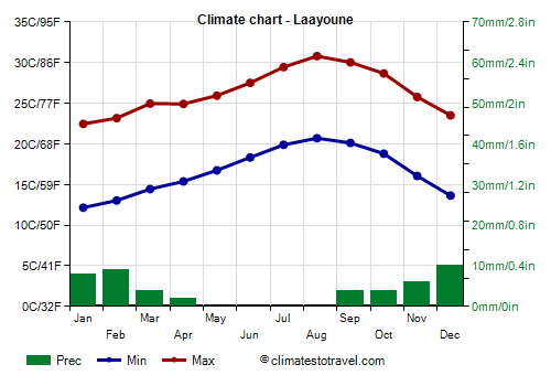
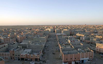
Laayoune (El Aaiún), is located in the north-west, but since it is not exactly on the coast, it becomes hot in summer, so that the average maximum temperature is 30/31 °C (86/88 °F) from July to September, while on the coast, it remains around 24/26 °C (75/79 °F).
During the most intense heat waves, the temperature reached 45 °C (113 °F) from May to September.
Precipitation, just 45 millimeters (1.8 inches) per year, is at desert levels, with rare and sporadic rains from autumn to spring.
On the coast west of Laayoune (Laayoune Plage), the
sea is never warm, and only reaches 21/22 °C (70/72 °F) from July to November. On the other hand, it is very cool in winter and spring, but not impossible for swimming.

Dakhla

In
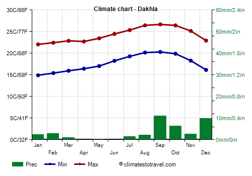
Dakhla (formerly Villa Cisneros), located in the central-southern part of the coast and practically at the Tropic, temperatures are spring-like for most of the year, since the city is located on a peninsula, where the wind from the ocean prevails all year round. Highs range from around 22 °C (71.5 °F) in January to 26.5 °C (79.5 °F) from August to October, and are reminiscent of those in the Canary Islands.
Here too, rainfall is scarce, just 40 mm (1.6 in) per year, with rare and sporadic rains in winter, and some rare rains even in summer.
The sun in Dakhla, as in the rest of the country, shines all year round, since clear skies prevail, however, summer is not sunnier than winter, because mists and fogs can form in the early hours of the day.
Even in the central-south of Western Sahara, the
sea is never warm, and only reaches 21/22 °C (70/72 °F) from July to November.
In the far south, near the border with Mauritania, the sea becomes a bit warmer from July to October, in fact, in
Lagouira (or La Guera), it reaches 24/24.5 °C (75/76 °F) from August to October.
Inland areas
In inland areas, summer becomes decidedly hotter, especially in areas further from the sea. Here, the temperature can exceed 40 °C (104 °F) from April to October, and 45 °C (113 °F) in summer.
Smara

In
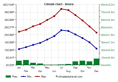
Smara (or Semara), located in the northern inland areas, the maximum temperatures reach 36/37 °C (97/99 °F) in July and August.
Here too, the rainfall is very scarce, just above 40 mm (1.5 in) per year.
Further to the east, towards the border with Algeria in the north-east and Mauritania in the center-south, it is even hotter, and highs exceed 40 °C (104 °F) in summer.
When to go
In order to avoid the heat, the best period to visit the Western Sahara (especially the
interior) goes from
December to February. It is necessary to dress in layers, because it can get warm during the day, while it can get cold at night.
Along the
coast, for swimming and sunbathing, you can go from
July to October. As mentioned above, the Atlantic waters are cool even in summer (except in the far south in August and September), and in the morning, fog and mist can form along the coast.
What to pack in the suitcase
In
winter: for the coast: bring spring/autumn clothes, a jacket and a sweater; for the desert, bring light clothes, but also a sweater, a jacket for the evening, a scarf for the wind-borne sand and dust.
In
summer: on the coast, bring light clothes, but also a pair of jeans, a sweatshirt, a light jacket and a scarf, especially in June and July. For inland and desert areas, bring loose-fitting, light-colored clothing, light and long shirts and pants, a sun hat and a desert turban, sunglasses (even graduated instead of contact lenses); a sleeping bag and a sweatshirt for overnight stays outdoors; hiking boots or sandals.
For women, it is best to avoid shorts and miniskirts.
Climate data - Western Sahara
| Agounit (300 meters) |
|---|
|
| Jan | Feb | Mar | Apr | May | Jun | Jul | Aug | Sep | Oct | Nov | Dec |
|---|
| Min temp. | 13 | 15 | 17 | 19 | 21 | 23 | 26 | 28 | 26 | 23 | 18 | 15 |
|---|
| Max temp. | 24 | 26 | 29 | 32 | 35 | 38 | 41 | 41 | 38 | 34 | 29 | 25 |
|---|
| Precip. | 5 | 0 | 0 | 0 | 0 | 0 | 5 | 10 | 20 | 5 | 5 | 5 |
|---|
|
|
|
| Sun hours | 9 | 9 | 10 | 11 | 11 | 10 | 10 | 10 | 9 | 9 | 9 | 8 |
|---|
|
| Dakhla |
|---|
|
| Jan | Feb | Mar | Apr | May | Jun | Jul | Aug | Sep | Oct | Nov | Dec |
|---|
| Min temp. | 15 | 15 | 16 | 16 | 17 | 18 | 19 | 20 | 20 | 20 | 18 | 16 |
|---|
| Max temp. | 22 | 22 | 23 | 23 | 23 | 24 | 25 | 26 | 27 | 26 | 25 | 23 |
|---|
| Precip. | 0 | 5 | 0 | 0 | 0 | 0 | 0 | 0 | 10 | 5 | 5 | 10 |
|---|
| Prec. days | 1 | 1 | 1 | 1 | 1 | 0 | 0 | 1 | 2 | 1 | 1 | 2 |
|---|
| Humidity | 64% | 68% | 72% | 73% | 74% | 77% | 78% | 78% | 78% | 75% | 69% | 67% |
|---|
|
| Sun hours | 8 | 9 | 9 | 9 | 10 | 10 | 9 | 9 | 8 | 8 | 8 | 8 |
|---|
| Sea temp | 19 | 18 | 18 | 19 | 19 | 20 | 20 | 21 | 22 | 22 | 21 | 20 |
|---|
| Laayoune |
|---|
|
| Jan | Feb | Mar | Apr | May | Jun | Jul | Aug | Sep | Oct | Nov | Dec |
|---|
| Min temp. | 12 | 13 | 14 | 15 | 17 | 18 | 20 | 21 | 20 | 19 | 16 | 14 |
|---|
| Max temp. | 22 | 23 | 25 | 25 | 26 | 28 | 29 | 31 | 30 | 29 | 26 | 24 |
|---|
| Precip. | 10 | 10 | 5 | 0 | 0 | 0 | 0 | 0 | 5 | 5 | 5 | 10 |
|---|
| Prec. days | 2 | 2 | 1 | 0 | 0 | 0 | 0 | 0 | 1 | 1 | 2 | 2 |
|---|
| Humidity | 58% | 62% | 63% | 63% | 64% | 66% | 67% | 67% | 67% | 68% | 64% | 60% |
|---|
|
| Sun hours | 8 | 8 | 9 | 10 | 10 | 10 | 9 | 9 | 8 | 8 | 8 | 8 |
|---|
| Sea temp | 19 | 18 | 18 | 19 | 19 | 20 | 21 | 22 | 22 | 22 | 21 | 20 |
|---|
| Lagouira |
|---|
|
| Jan | Feb | Mar | Apr | May | Jun | Jul | Aug | Sep | Oct | Nov | Dec |
|---|
| Min temp. | 15 | 16 | 16 | 17 | 18 | 19 | 20 | 21 | 22 | 20 | 18 | 17 |
|---|
| Max temp. | 25 | 26 | 27 | 27 | 27 | 29 | 28 | 29 | 31 | 31 | 29 | 26 |
|---|
| Precip. | 0 | 5 | 0 | 0 | 0 | 0 | 0 | 5 | 5 | 5 | 0 | 0 |
|---|
| Prec. days | 0 | 0 | 0 | 0 | 0 | 0 | 0 | 0 | 1 | 0 | 0 | 0 |
|---|
|
|
|
| Sea temp | 19 | 19 | 19 | 19 | 19 | 20 | 22 | 24 | 25 | 24 | 22 | 21 |
|---|
| Smara |
|---|
|
| Jan | Feb | Mar | Apr | May | Jun | Jul | Aug | Sep | Oct | Nov | Dec |
|---|
| Min temp. | 11 | 12 | 13 | 15 | 17 | 19 | 23 | 23 | 20 | 18 | 15 | 11 |
|---|
| Max temp. | 22 | 23 | 26 | 27 | 30 | 32 | 37 | 36 | 33 | 30 | 26 | 22 |
|---|
| Precip. | 5 | 5 | 5 | 0 | 0 | 0 | 0 | 0 | 5 | 5 | 5 | 10 |
|---|
| Prec. days | 2 | 2 | 1 | 0 | 1 | 1 | 0 | 1 | 1 | 1 | 2 | 2 |
|---|
|
|
|
|
See also the
temperatures month by month