Select units of measurement for the temperature and rainfall tables (metric or imperial).
Average weather, temperature, rainfall, sunshine
In Libya, the climate is
Mediterranean in the thin coastal strip and
desert in the interior.
Actually, although the temperatures on the coast are typical of the Mediterranean climate, the
rainfall level is very low, semi-desert in Tripolitania and Cirenaica, and even desert in the Gulf of Sidra (or Sirte). Only in the hills near the coast of Cyrenaica (called
Jebel Akhdar), precipitation is between 400 and 700 millimeters (16 and 27.5 inches) per year, so much so that they are covered by a Maquis shrubland.
The climate in detail
The seasons
In
winter, temperatures in northern Libya are very mild. There may be some rain, due to
low pressure areas coming from the Atlantic Ocean or the Mediterranean Sea. Between one weather front and another, there are long periods of good weather even in winter.
Since the period when the rain can fall is limited, during some years, a decrease in the winter rainfall may cause
drought, whose effects are felt until the following autumn.
In the centre-south, in the vast desert areas, the sun usually shines, with very mild days, and very cool or cold nights.
In
summer, the average maximum temperature ranges from 30 °C (86 °F) along the coast, to 35/37 °C (95/99 °F) in the north-central inland area, to 40/41 °C (104/406 °F) in the south.
Along the coast, air humidity is high, though sea
breezes blow in the afternoon, relieving the heat. Actually, in summer, the
northern winds blow even at high altitude, since they are due to the baric configuration of the region, with a high pressure system over the western part of the Mediterranean and a low pressure system on the eastern side. That's why the Libyan desert is not as hot as the Algerian desert.
The sun shines and it almost never rains throughout Libya. However, in the southern part, in full desert, some
showers may occur because of the African monsoon, which affects the Sahel region in the warmest months, and whose extreme offshoots can sometimes arrive here.
Throughout the year, but more often in spring and autumn, Libya can be affected by the
Ghibli, a hot and dry wind, which is able to raise dust and cause sudden increases in temperature.
This phenomenon is even more evident along the coast, where it also produces a sudden drop in relative humidity, which here is generally high because of the influence of the sea. In these cases, the temperature can exceed 40 °C (104 °F) from April to October even on the coast, while in winter it can reach 30 °C (86 °F).
The coast
The main Libyan cities located on the coast (Tripoli, Benghazi, Misrata) have an arid Mediterranean climate, with mild, quite rainy winters and hot, sunny summers, with highs in July and August around 30 °C (86 °F). In summer, as mentioned, the air is humid and the north wind prevails.
Along the coast, which is the only plain area that receives non-sporadic
rains, most of the rainfall occurs from October to early April, with a peak in December and January.
The amount is usually low, between 200 and 350 mm (8 and 14 in) per year in Tripolitania and Cyrenaica, and between 100 and 200 mm (4 and 8 in) in the Gulf of Sirte (which is definitely desert in the southernmost part), while to the east of Cyrenaica, in the easternmost part of the coast, on the border with Egypt (see Tobruk), it drops again to around 100 mm (4 in).
Between the cities of the coast, Tripoli, located in the western part, is the rainiest city, and receives 330 millimeters (13 inches) of rain per year, with a peak of 60/70 mm (2.4/2.8 in) per month between November and January. In Benghazi, rainfall amounts to 265 mm (10.4 in) per year, while in Misrata, near the dry Gulf of Sirte, it amounts to just 190 mm (7.5 in). In Sirte, in the gulf of the same name, it's about 180 mm (7 in), and in Tobruk, located in the east, it drops to only 110 mm (4.3 in).
Benghazi
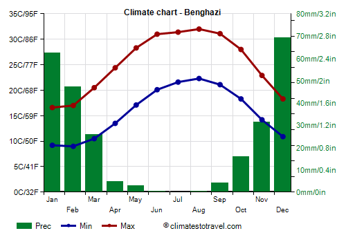
For example, in
Benghazi, on the coast of Cyrenaica, the average temperature ranges from 13 °C (55.5 °F) in January to 27 °C (80.5 °F) in August.
As mentioned, in Benghazi, 265 mm (10.4 in) of rain fall per year.
The
sea in Libya is warm enough to swim in from July to October, while it is a bit cool in June and November.
Temperatures similar to those of Benghazi are also recorded in the old neighborhoods of
Tripoli, however, in the meteorological station of the
international airport, which is located about 20 km (12 mi) further south, and therefore further from the sea and closer to the desert, the summer temperatures are much higher.
About 20 km (12 mi) south of Tripoli airport we find
'Aziziya, where the average of the July and August highs rises to 37/38 °C (99/100 °F), and where it was mistakenly assumed that the world highest record had occurred, due an incorrect measurement carried out in 1922.
Hill areas
In the hilly areas, the climate is milder and more rainy, and therefore resembles the classical Mediterranean climate.
Bayda
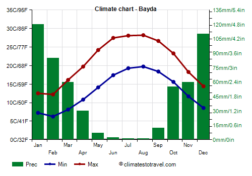
In
Bayda, located at 600 meters (2,000 feet) above sea level, on the hills of Cyrenaica, the daily average temperature ranges from 9.5 °C (49 °F) in February to 24 °C (75 °F) in August.
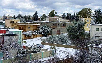
Bayda receives 540 mm (21 in) of rain per year. Here, in winter, owing to the altitude, it can even snow during cold waves.
South of Tripoli, there is a mountain range, the
Nafusa Mountains, where there are some cities located at an altitude of almost 1,000 meters (3,300 feet), such as Nalut, Zintan, Lefren, Gharyan, which, in winter, are slightly colder than the same Bayda.
The desert
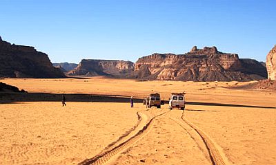
In the vast desert regions of Libya, the climate is subtropical desert, and
good weather prevails throughout the year.
During winter, the temperature range is high, in fact, nights are cold (the temperature can drop to around freezing, and even a few degrees below in the north-central part), while days are pleasant, around 20 °C (68 °F). The daytime temperature exceeds 30 °C (86 °F) from April to October.
In summer, the highest recorded temperatures are around 47/48 °C (117/118 °F).
The rains are very scarce and sporadic, in the form of downpours: some areas can see no rain for years.
The desert is almost everywhere uninhabited, except near the oases, which are fed by water springs emerging from underground, such as the oases of
Kufra and Sabha.
Sabha
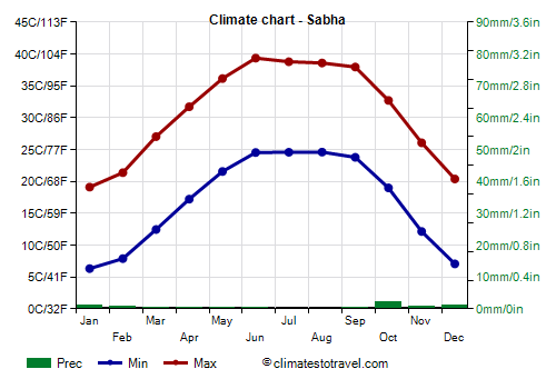
In
Sabha, located at 400 meters (1,300 feet) above sea level, in central-western Libya, at 27 degrees north latitude, the average temperature ranges from 12.7 °C (54.9 °F) in January to 31.9 °C (89.4 °F) in June, which here is the hottest month.
When to go
While waiting for the conditions in Libya to be normalized, we can give you some indication on the best period as regards to the climate.
If you want to visit Tripoli, Benghazi and the main
northern cities, you can choose spring and autumn, and in particular, from mid-March to mid-April and from mid-October to mid-November.
If you want to visit the
desert areas, you can choose the winter, from December to February, keeping in mind that it can get cold at night.
The
bathing season runs from mid-May to mid-October, although the sea begins to be warm in July.
What to pack
In
winter: in Tripoli and the coast, bring spring/autumn clothes, a jacket and a sweater, and a raincoat or umbrella. In the desert, bring spring/autumn clothes (light for the day), a scarf for the wind-borne sand and dust, a sweater, a wind jacket, and a warm jacket for the night. In Bayda and the Nafusa Mountains, it's better to add some warm clothes, such as a sweater or fleece, and a down jacket.
In
summer: in general, bring loose-fitting, light-colored clothing, light and long shirts and pants, a wide-brimmed hat, a light scarf, sunglasses (even graduated instead of contact lenses), and comfortable and breathable shoes. On the coast, a light sweatshirt for the evening. In the desert, a sweatshirt for the night, a sleeping bag for outdoor overnight stays, desert boots or sandals. It's best for women to avoid shorts and miniskirts.
Climate data - Libya
| Ajdabiya |
|---|
|
| Jan | Feb | Mar | Apr | May | Jun | Jul | Aug | Sep | Oct | Nov | Dec |
|---|
| Min temp. | 9 | 9 | 11 | 15 | 18 | 21 | 22 | 22 | 22 | 18 | 13 | 10 |
|---|
| Max temp. | 18 | 19 | 23 | 27 | 31 | 33 | 33 | 34 | 34 | 30 | 25 | 20 |
|---|
| Precip. | 40 | 25 | 5 | 0 | 0 | 0 | 0 | 0 | 0 | 10 | 20 | 25 |
|---|
| Prec. days | 9 | 4 | 4 | 2 | 1 | 0 | 0 | 0 | 1 | 2 | 4 | 8 |
|---|
|
|
| Sun hours | 7 | 8 | 8 | 9 | 10 | 11 | 12 | 12 | 10 | 9 | 8 | 6 |
|---|
|
| Bayda (600 meters) |
|---|
|
| Jan | Feb | Mar | Apr | May | Jun | Jul | Aug | Sep | Oct | Nov | Dec |
|---|
| Min temp. | 7 | 6 | 8 | 11 | 14 | 17 | 19 | 20 | 18 | 16 | 12 | 9 |
|---|
| Max temp. | 13 | 12 | 16 | 20 | 24 | 27 | 28 | 28 | 27 | 23 | 18 | 14 |
|---|
| Precip. | 120 | 85 | 60 | 30 | 5 | 0 | 0 | 0 | 10 | 55 | 60 | 110 |
|---|
| Prec. days | 13 | 11 | 7 | 4 | 2 | 0 | 0 | 0 | 1 | 4 | 7 | 11 |
|---|
|
|
|
|
| Benghazi |
|---|
|
| Jan | Feb | Mar | Apr | May | Jun | Jul | Aug | Sep | Oct | Nov | Dec |
|---|
| Min temp. | 9 | 9 | 10 | 14 | 17 | 20 | 22 | 22 | 21 | 18 | 14 | 11 |
|---|
| Max temp. | 17 | 17 | 20 | 24 | 28 | 31 | 31 | 32 | 31 | 28 | 23 | 18 |
|---|
| Precip. | 60 | 45 | 25 | 5 | 5 | 0 | 0 | 0 | 5 | 15 | 30 | 70 |
|---|
| Prec. days | 9 | 8 | 4 | 1 | 1 | 0 | 0 | 0 | 1 | 2 | 5 | 10 |
|---|
| Humidity | 72% | 70% | 62% | 53% | 50% | 52% | 62% | 63% | 58% | 60% | 64% | 70% |
|---|
| Day length | 10 | 11 | 12 | 13 | 14 | 14 | 14 | 13 | 12 | 11 | 10 | 10 |
|---|
| Sun hours | 6 | 8 | 8 | 9 | 10 | 11 | 13 | 12 | 10 | 8 | 7 | 6 |
|---|
| Sea temp | 18 | 17 | 16 | 17 | 20 | 23 | 26 | 27 | 26 | 25 | 22 | 19 |
|---|
| Derna |
|---|
|
| Jan | Feb | Mar | Apr | May | Jun | Jul | Aug | Sep | Oct | Nov | Dec |
|---|
| Min temp. | 12 | 12 | 13 | 15 | 18 | 22 | 24 | 25 | 23 | 21 | 17 | 13 |
|---|
| Max temp. | 18 | 17 | 19 | 20 | 24 | 27 | 28 | 29 | 29 | 27 | 23 | 19 |
|---|
| Precip. | 60 | 40 | 30 | 10 | 5 | 0 | 0 | 0 | 5 | 30 | 35 | 55 |
|---|
| Prec. days | 11 | 8 | 7 | 3 | 2 | 0 | 0 | 0 | 1 | 5 | 6 | 5 |
|---|
|
|
| Sun hours | 5 | 7 | 7 | 8 | 9 | 10 | 10 | 10 | 8 | 7 | 6 | 5 |
|---|
|
| Ghadames (345 meters) |
|---|
|
| Jan | Feb | Mar | Apr | May | Jun | Jul | Aug | Sep | Oct | Nov | Dec |
|---|
| Min temp. | 6 | 8 | 12 | 16 | 21 | 25 | 26 | 26 | 24 | 18 | 11 | 7 |
|---|
| Max temp. | 18 | 21 | 26 | 30 | 35 | 40 | 41 | 41 | 38 | 32 | 24 | 19 |
|---|
| Precip. | 5 | 5 | 5 | 5 | 0 | 0 | 0 | 0 | 0 | 5 | 0 | 5 |
|---|
| Prec. days | 1 | 1 | 2 | 1 | 0 | 0 | 0 | 0 | 0 | 1 | 1 | 1 |
|---|
| Humidity | 49% | 40% | 34% | 31% | 25% | 23% | 21% | 24% | 30% | 36% | 41% | 49% |
|---|
| Day length | 10 | 11 | 12 | 13 | 14 | 14 | 14 | 13 | 12 | 11 | 11 | 10 |
|---|
| Sun hours | 8 | 8 | 8 | 9 | 10 | 10 | 12 | 11 | 9 | 8 | 8 | 8 |
|---|
|
| Ghat (665 meters) |
|---|
|
| Jan | Feb | Mar | Apr | May | Jun | Jul | Aug | Sep | Oct | Nov | Dec |
|---|
| Min temp. | 5 | 7 | 13 | 18 | 23 | 26 | 26 | 26 | 24 | 19 | 12 | 7 |
|---|
| Max temp. | 20 | 24 | 29 | 34 | 38 | 40 | 40 | 40 | 38 | 34 | 28 | 22 |
|---|
| Precip. | 0 | 0 | 0 | 0 | 0 | 0 | 0 | 0 | 0 | 0 | 0 | 0 |
|---|
| Prec. days | 0 | 0 | 0 | 0 | 0 | 0 | 0 | 0 | 0 | 0 | 0 | 0 |
|---|
|
|
|
|
| Hun (260 meters) |
|---|
|
| Jan | Feb | Mar | Apr | May | Jun | Jul | Aug | Sep | Oct | Nov | Dec |
|---|
| Min temp. | 5 | 6 | 10 | 14 | 18 | 21 | 22 | 22 | 21 | 17 | 11 | 6 |
|---|
| Max temp. | 19 | 21 | 26 | 31 | 34 | 37 | 38 | 38 | 36 | 32 | 26 | 20 |
|---|
| Precip. | 5 | 5 | 5 | 5 | 0 | 0 | 0 | 0 | 0 | 0 | 0 | 0 |
|---|
| Prec. days | 1 | 1 | 1 | 0 | 0 | 0 | 0 | 0 | 0 | 0 | 0 | 0 |
|---|
|
|
|
|
| Kufra (380 meters) |
|---|
|
| Jan | Feb | Mar | Apr | May | Jun | Jul | Aug | Sep | Oct | Nov | Dec |
|---|
| Min temp. | 8 | 10 | 14 | 19 | 23 | 25 | 26 | 26 | 24 | 20 | 14 | 9 |
|---|
| Max temp. | 20 | 23 | 28 | 34 | 37 | 39 | 39 | 39 | 37 | 33 | 27 | 21 |
|---|
| Precip. | 0 | 0 | 0 | 0 | 0 | 0 | 0 | 0 | 0 | 0 | 0 | 0 |
|---|
| Prec. days | 0 | 0 | 0 | 0 | 0 | 0 | 0 | 0 | 0 | 0 | 0 | 0 |
|---|
| Humidity | 39% | 30% | 22% | 16% | 16% | 16% | 18% | 19% | 23% | 27% | 33% | 41% |
|---|
| Day length | 11 | 11 | 12 | 13 | 13 | 14 | 13 | 13 | 12 | 12 | 11 | 11 |
|---|
| Sun hours | 9 | 9 | 9 | 10 | 10 | 11 | 12 | 12 | 10 | 10 | 10 | 9 |
|---|
|
| Misrata |
|---|
|
| Jan | Feb | Mar | Apr | May | Jun | Jul | Aug | Sep | Oct | Nov | Dec |
|---|
| Min temp. | 10 | 10 | 12 | 14 | 17 | 20 | 23 | 24 | 23 | 20 | 15 | 11 |
|---|
| Max temp. | 18 | 19 | 21 | 24 | 27 | 30 | 32 | 32 | 32 | 29 | 24 | 20 |
|---|
| Precip. | 50 | 30 | 20 | 10 | 5 | 0 | 0 | 0 | 10 | 30 | 40 | 55 |
|---|
| Prec. days | 7 | 6 | 3 | 2 | 1 | 0 | 0 | 0 | 1 | 3 | 5 | 7 |
|---|
|
|
| Sun hours | 6 | 8 | 8 | 8 | 10 | 10 | 12 | 11 | 9 | 8 | 7 | 6 |
|---|
|
| Nalut (620 meters) |
|---|
|
| Jan | Feb | Mar | Apr | May | Jun | Jul | Aug | Sep | Oct | Nov | Dec |
|---|
| Min temp. | 6 | 7 | 10 | 13 | 17 | 20 | 22 | 23 | 21 | 17 | 12 | 8 |
|---|
| Max temp. | 14 | 16 | 20 | 25 | 29 | 33 | 35 | 35 | 32 | 27 | 20 | 15 |
|---|
| Precip. | 15 | 25 | 20 | 10 | 5 | 0 | 0 | 0 | 5 | 20 | 10 | 20 |
|---|
| Prec. days | 2 | 2 | 2 | 1 | 1 | 0 | 0 | 0 | 1 | 2 | 2 | 2 |
|---|
|
|
|
|
| Sabha (400 meters) |
|---|
|
| Jan | Feb | Mar | Apr | May | Jun | Jul | Aug | Sep | Oct | Nov | Dec |
|---|
| Min temp. | 6 | 8 | 12 | 17 | 22 | 25 | 25 | 25 | 24 | 19 | 12 | 7 |
|---|
| Max temp. | 19 | 21 | 27 | 32 | 36 | 39 | 39 | 39 | 38 | 33 | 26 | 20 |
|---|
| Precip. | 0 | 0 | 0 | 0 | 0 | 0 | 0 | 0 | 0 | 0 | 0 | 0 |
|---|
| Prec. days | 0 | 0 | 0 | 0 | 0 | 0 | 0 | 0 | 0 | 1 | 0 | 0 |
|---|
| Humidity | 47% | 38% | 28% | 25% | 22% | 21% | 24% | 25% | 26% | 31% | 37% | 45% |
|---|
| Day length | 11 | 11 | 12 | 13 | 14 | 14 | 14 | 13 | 12 | 12 | 11 | 10 |
|---|
| Sun hours | 8 | 9 | 9 | 9 | 10 | 11 | 12 | 12 | 10 | 9 | 9 | 8 |
|---|
|
| Sirte |
|---|
|
| Jan | Feb | Mar | Apr | May | Jun | Jul | Aug | Sep | Oct | Nov | Dec |
|---|
| Min temp. | 10 | 10 | 12 | 14 | 17 | 20 | 23 | 24 | 23 | 20 | 15 | 11 |
|---|
| Max temp. | 19 | 20 | 22 | 24 | 27 | 29 | 31 | 32 | 32 | 30 | 25 | 20 |
|---|
| Precip. | 40 | 30 | 15 | 5 | 5 | 0 | 0 | 0 | 10 | 15 | 20 | 45 |
|---|
| Prec. days | 6 | 4 | 2 | 1 | 1 | 0 | 0 | 0 | 1 | 2 | 3 | 6 |
|---|
|
|
|
|
| Tripoli |
|---|
|
| Jan | Feb | Mar | Apr | May | Jun | Jul | Aug | Sep | Oct | Nov | Dec |
|---|
| Min temp. | 7 | 7 | 10 | 13 | 16 | 20 | 21 | 22 | 21 | 18 | 12 | 8 |
|---|
| Max temp. | 18 | 19 | 23 | 26 | 31 | 34 | 36 | 36 | 34 | 30 | 24 | 19 |
|---|
| Precip. | 60 | 30 | 30 | 15 | 5 | 0 | 0 | 0 | 15 | 45 | 60 | 70 |
|---|
| Prec. days | 9 | 6 | 6 | 3 | 2 | 1 | 0 | 0 | 2 | 7 | 7 | 9 |
|---|
| Humidity | 69% | 66% | 61% | 55% | 51% | 50% | 52% | 54% | 57% | 59% | 63% | 68% |
|---|
| Day length | 10 | 11 | 12 | 13 | 14 | 14 | 14 | 13 | 12 | 11 | 10 | 10 |
|---|
| Sun hours | 6 | 7 | 7 | 8 | 10 | 10 | 12 | 11 | 9 | 7 | 6 | 5 |
|---|
| Sea temp | 17 | 16 | 16 | 17 | 19 | 22 | 26 | 27 | 27 | 25 | 22 | 20 |
|---|
| Yafran (690 meters) |
|---|
|
| Jan | Feb | Mar | Apr | May | Jun | Jul | Aug | Sep | Oct | Nov | Dec |
|---|
| Min temp. | 7 | 8 | 10 | 13 | 17 | 21 | 23 | 23 | 21 | 18 | 12 | 8 |
|---|
| Max temp. | 13 | 15 | 19 | 23 | 28 | 32 | 34 | 34 | 31 | 26 | 19 | 14 |
|---|
| Precip. | 50 | 45 | 35 | 15 | 10 | 5 | 0 | 0 | 5 | 25 | 20 | 45 |
|---|
| Prec. days | 4 | 4 | 3 | 2 | 1 | 0 | 0 | 0 | 1 | 2 | 3 | 5 |
|---|
|
|
|
|
| Zuwarah |
|---|
|
| Jan | Feb | Mar | Apr | May | Jun | Jul | Aug | Sep | Oct | Nov | Dec |
|---|
| Min temp. | 9 | 10 | 12 | 15 | 18 | 21 | 24 | 25 | 24 | 20 | 14 | 10 |
|---|
| Max temp. | 18 | 19 | 21 | 23 | 26 | 28 | 31 | 32 | 31 | 29 | 24 | 20 |
|---|
| Precip. | 35 | 30 | 15 | 10 | 5 | 0 | 0 | 0 | 15 | 20 | 30 | 45 |
|---|
| Prec. days | 4 | 4 | 2 | 1 | 1 | 0 | 0 | 0 | 2 | 2 | 4 | 6 |
|---|
|
|
|
|
See also the
temperatures month by month