Morocco has a
Mediterranean climate on the northern coast,
mild and semi-arid on the Atlantic coast, and
desert in the inland areas. In the
mountains, on the other hand, the climate is gradually more continental and colder as the altitude increases.
Index
Atlantic coast
The
Atlantic coast enjoys a mild climate, similar to that of the Mediterranean but
even milder. There are spring-like winters, with long periods of good weather, and pleasantly warm, sunny summers.
The
rains are not abundant, however, from November to March, they can sometimes be intense and concentrated in a few hours, and they can fill the ancient river beds (called
wadis) and cause flooding.
A
cool sea current flows west of northern Africa, so the ocean remains cool even in summer. Furthermore, because of this current, along the coast,
fogs and mists can form on summer mornings, especially in the southern part. In fact, strange as it may seem, the sea is a bit colder in the southern part of the coast (see Essaouira, Agadir) than in the northern part (from Tangier to Casablanca).

Further to the north, in
Tangier, in the northernmost part of the Atlantic coast, the average ranges from 12.5 °C (54.5 °F) in January to 25 °C (77 °F) in August. In summer, this is the warmest area on the Atlantic coast because, as mentioned, the effects of the cold sea current are felt less.
In this northern part of the coast, rainfall is relatively abundant; in fact, weather disturbances arrive quite frequently from October to April.
In Tangier, the sun can shine even in winter, but less than in the central-southern part, as Atlantic disturbances pass more frequently, while the summer is generally sunny.
The sea temperature, in this northern part of the coast, is never very warm, however, it reaches 23.5 °C (74.5 °F) in August.
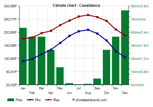
![]() Climate chart - Casablanca
Climate chart - Casablanca
Further south we find Rabat, the capital, and Casablanca, the largest city.
Even though the climate is mild,
heat waves can occur when the wind blows from the desert. However, this happens less frequently than in the central-southern part of the coast.
In
Casablanca, the average temperature ranges from 13 °C (55.5 °F) in January to 24 °C (75 °F) in August. The rains are rarer than in Tangiers, in fact they amount to about 400 mm (16 in) a year, and are concentrated from November to April.
In Casablanca too, the sea is not warm, however, it reaches 23.5 °C (74.5 °F) in August.
In
Rabat, the capital, the climate is similar to that of Casablanca.

In
Agadir, in the southern part of the Atlantic coast, the daily average temperature ranges from 14.5 °C (58 °F) in January to 23 °C (73 °F) in August. Although the normal temperatures are mild, a hot wind from the interior can blow for a few days throughout the year, bringing warm days in winter, with temperatures around 30 °C (86 °F), and scorching days in summer, with peaks above 40 °C (104 °F).
In Agadir the rains are scarce, so much so that they amount to 255 mm (10 in) per year, and occurs almost all from late autumn to early spring.
The sun in Agadir shines all year round, but the sunniest season is spring, while in summer, as we mentioned, fogs can form in the morning.
The sea temperature remains very cool even in summer, and reaches a maximum of 21 °C (70 °F) in August and September.
South of Agadir, the rains are even rarer, at desert level.
In the central-southern part of the coast, in the most exposed places (see
Essaouira,
Sidi Ifni, Tarfaya), summer is particularly cool and windy, and also foggy in the morning (although in recent years, hot African air masses have often prevailed).
Mediterranean coast
On the
Mediterranean coast, the climate is typically Mediterranean: winters are mild and moderately rainy, and resemble those of the northern part of the Atlantic coast, while summers are hot and sunny, and they are hotter than on the Atlantic coast.
Rainfall is more abundant in the northern part, overlooking the Strait of Gibraltar (see
Tétouan), where it exceeds 650 mm (25.5 in) per year, while it is quite scarce in the eastern part (see Al Hoceima), where it drops below 400 mm (15.5 in) per year.
In
Al Hoceima, the temperature ranges from 12 °C (53.5 °F) in January to 25 °C (77 °F) in August. In the Spanish exclave of Melilla, the climate is similar.
Sudden increases in temperature occur here as well, when the wind blows from the desert, a situation more common in spring.
Infiltration from the Atlantic Ocean makes the sea a little colder than in other Mediterranean countries, and similar to that of Tangier, so much so that even here the water temperature reaches 23.5 °C (74 °F) in August.
Inland areas
Moving towards the interior, the effect of the cold Atlantic current is sharply reduced, so the
imperial cities have a climate characterized by hot summers, while winters are slightly colder, partly because of the higher altitude.
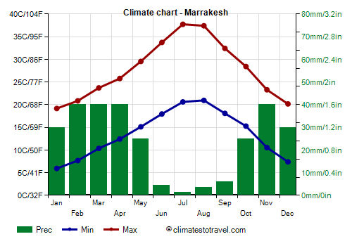
![]() Climate chart - Marrakesh
Climate chart - Marrakesh
In particular, in
Marrakesh, 450 meters (1,450 ft) above sea level, the average ranges from 12.5 °C (54.5 °F) in January to 29 °C (84.5 °F) in July and August. The sun shines all year round; the rains are concentrated from mid-October to April, and are usually not abundant. In summer, there are long sunny periods, interrupted by sporadic thunderstorms. In the worst moments, the temperature can exceed 45 °C (113 °F).
In the interior, the sun shines all year round. Here are the average sunshine hours per day in Marrakesh.

Further to the north,
Fez, 400 meters (1,300 feet) above sea level, is a bit cooler and rainier: the average temperature ranges from 10 °C (50 °F) in January to 27 °C (80.5 °F) in August; annual precipitation is about 700 mm (27.5 in). A similar climate is found in
Meknes, located at 500 meters (1,600 feet) above sea level, and a short distance from Fez.
Mountainous areas
In the
mountainous areas, the range of Atlas and of that of Rif to the north have a colder climate due to the altitude, and there are also ski resorts (see Ifrane). Summers are hot during the day up to fairly high altitudes, while nights are more or less cool depending on altitude. The highest peak is
Toubkal, 4,167 meters (13,671 feet) high.

In Ifrane, located at 1,700 meters (5,500 feet) above sea level, in the Middle Atlas, the average temperature ranges from 5 °C (41 °F) in January to 22 °C (71.5 °F) in August. On average, 1,100 mm (45 in) of rain fall per year; being on the western slope, in winter, it receives abundant precipitation. In winter, it can snow, even though the snowfalls are more abundant in the mountain peaks. In summer, when the sun dominates, every so often, some showers can occur.
The eastern slopes of the Atlas, towards Algeria, have an arid climate. In winter, the temperature is cold at night, while in summer, the heat is intense, though it is tempered by altitude, therefore it is least as compared with the Algerian desert. In
Errachidia, at 1,000 meters (3,300 feet) above sea level, the average daily temperature in July is around 33 °C (91 °F), with highs around 39 °C (102 °F). In
Ouarzazate, at 1,150 meters (3,770 feet), the climate is similar, albeit a little cooler.
When to go
If you want to visit the
imperial cities of Morocco while avoiding hot periods, you can choose
spring and autumn, in March-April and from October to mid-November. There may be both cold nights and hot days, but the temperature is generally pleasant, and there are many sunny days, although it can sometimes rain.
For a
beach holiday, you can go in
summer, on the Atlantic coast from July to September, and on the Mediterranean coast in July and August. As explained above, the waters of the Atlantic Ocean are cool even in summer, especially in the southern part, and fogs and mists may form in the morning along the coast, reducing the hours of sunshine.
What to pack
In
winter: on both the Atlantic and the Mediterranean coast, bring spring/autumn clothes, a jacket and a sweater, a raincoat or umbrella; for the imperial cities, you can add a warm hat for the evening; for the mountain areas, bring warm clothes, such as a down jacket and gloves; for the desert, bring light clothing, but also a sweater, a warm jacket for the evening, and a scarf for the wind-borne sand and dust.
In
summer: on the Mediterranean coast, bring light clothing, and a light sweatshirt for the evening; on the Atlantic coast, especially in Agadir and Essaouira, it's better to add a pair of jeans, a sweatshirt, a light jacket, and a scarf. For inland and desert areas, loose-fitting, light-colored clothing, light and long shirts and pants, a sun hat and a desert turban, sunglasses (even graduated instead of contact lenses), and a sweatshirt for the evening; a sleeping bag for overnight stays outdoors; hiking shoes or sandals. In the mountains, a sweater and a jacket for outdoor overnight stays.
It's better for women to avoid shorts and miniskirts, especially in rural and non-tourist areas.
Back to topSee also the
temperatures month by month