Select units of measurement for the temperature and rainfall tables (metric or imperial).
Average weather, temperature, rainfall, sunshine
In Niger, the climate is subtropical desert in the north, tropical semi-desert in the center, and tropical semi-arid of the savanna in the south. In fact, the rains increase from north to south because of the
African monsoon, which brings humidity and clouds from the Atlantic Ocean, in the June-September period.
Not surprisingly, the main cities, with the exception of Agadez, are located in the south.
Niger is a landlocked African country, located in the southern part of the Sahara. The far north is crossed by the Tropic of Cancer.
The climate in detail
The north
The north, part of the
Sahara desert, is mild in winter, but with strong temperature variations, so
it can get cold at night, while it can get hot during the day, especially in February. In the rest of the year, the climate is very hot, and the sky is almost always clear.
In winter, in the Djado Plateau and in the Aïr Massif, but sometimes also in the Ténéré Desert, nights can be cold, and the temperature can sometimes drop to around freezing (0 °C or 32 °F), while daytime temperatures are around 20/25 °C (68/77 °F). On the top of the Aïr, on
Mont Idoukal-n-Taghès, 2,022 meters (6,634 feet) high, night frosts are frequent.
In winter, a dry wind called
harmattan blows, raising dust and sand, which can veil the sun, especially from January onwards.
In the rest of the year, in the north, scorching heat reigns supreme, at least in the lowlands, with highs around 40 °C (104 °F) from April to September, and peaks of as high as 50 °C (122 °F).
Bilma
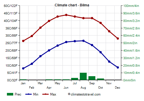
In
Bilma, located in the north-east, at 350 meters (1,150 feet) above sea level, the maximum temperatures reach 40 °C (104 °F) in April, and exceed them from May to September.
The rains in the north are rare and sporadic, however, there may be some rare showers in summer.
In Bilma, the sun shines all year round, although in summer, some cloud banks can sometimes reach the area.
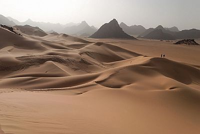
The center
The central-southern region, known as
Sahel, receives rainfall during the summer months. The northernmost part, at the boundary with the previous region, is still desert, and receives little rainfall: in the Aïr Massif and in Agadez, the annual amount is slightly above 100 millimeters (4 inches), with a maximum in August, when 50 mm (2 in) of rain fall in Agadez.
Agadez
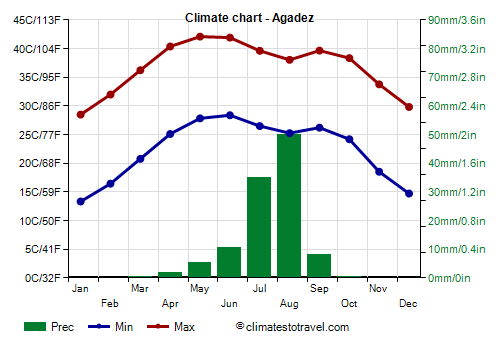
In
Agadez, located in the center of Niger at an altitude of 530 metres (1,740 ft), the winter nights are not as cold as in Bilma, while summer is less hot.
Since the temperature of the coldest month exceeds 20 °C (68 °F), the climate can be described as tropical.
The sun in Agadez shines all year round, but in summer, some cloud banks can sometimes reach this area.
The south
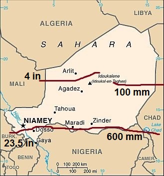
The map above depicts the lines of equal rainfall (called isohyets) of 100 mm and 600 mm (4 and 23.5 in) per year in the country.
As you can see, rainfall is moderate only in the southernmost part.
In Tahoua, in the south-west, rainfall amounts to 365 mm (14 in) per year, while in the area of Lake Chad, in the south-east, it amounts to about 250/300 mm (10/12 in) per year.
Niamey

In the capital,
Niamey, 585 mm (23 in) of rain fall per year, with the first sporadic showers in the afternoon or evening as early as in May, which increase progressively until August, when rainfall reaches 205 mm (8 in), and then they decrease by September and cease in early October.
In Niamey and in the rest of the south, the temperature also follows a different pattern compared with the north.
Winter is warmer, with highs exceeding 30 °C (86 °F) even in January. Sometimes, it can get quite cold at night, but with lows of 7/8 °C (45/46 °F), so not around the freezing point as happens in the north.
In spring, the temperature rises quickly, in fact, the daytime average reaches 40 °C (104 °F) in March, and it can exceed 45 °C (113 °F) in May.
Then the
monsoon arrives, lowering the temperature in summer, but at the cost of an increase in humidity. In August, highs return to 33 °C (91 °F), as in January, although night temperatures are higher and the humidity makes the heat muggy.
After the monsoon, hot weather returns, with highs around 37/38 °C (98/100 °F) in October and November, before winter, which brings a bit of cool weather, at least at night.
In winter, the sky is clear, though the sun may be veiled because of the
Harmattan, which raises a fine dust that penetrates everywhere and makes the sky whitish. South-central Niger is one of the hardest-hit areas by the Harmattan across the Sahel. In summer, the sunshine hours decrease a little because of the monsoon, and August is the least sunny month.
To the east of the capital, cities such as Maradi and Zinder have a climate similar to that of Niamey.
In the
far south, rainfall is more abundant, so much so that it exceeds 600 mm (23.5 in) per year; therefore, we are out of the Sahel proper.
Gaya

In
Gaya, 825 mm (32.5 in) of rain fall per year, of which 70 mm (2.8 in) fall already in May, and with maximum of and 250 mm (10 in) in August. Here, the landscape becomes definitely green in the summer months.
The hottest month in the far south is April, in fact, the temperature begins to decrease as early as in May, while in summer, the heat is tropical, that is, uncomfortable because of high humidity.
When to go
The best time to travel to Niger is winter, from
December to mid-February, when the sun shines in the whole country, the air is dry and the temperature is usually acceptable.
In the south, it can get definitely hot during the day even at this time, but nights remain cool.
In the north, it can get cold at night, while generally, the temperature is pleasantly warm during the day.
In January, sand storms become more frequent, and in February, the heat begins to increase in the south, heading towards 40 °C (104 °F), so, all in all, the best month is
December.
What to pack
In
winter: bring light clothes for the day, long and made of natural fabric (cotton or linen), a desert turban for the wind-borne sand and dust, sunglasses (even graduated instead of contact lenses), a jacket and a sweater for the evening, desert boots or sandals, and a sweatshirt or sweater for boat excursions on the Niger River.
In
summer: in the desert, bring loose-fitting, light-colored clothing, long and made of natural fabric (cotton or linen), a desert turban, sunglasses, and comfortable and breathable shoes. A sweatshirt for the night and a sleeping bag to sleep outdoors. In Niamey and the south, light clothes, an umbrella or a light raincoat for the rain showers.
It's better for women to avoid shorts and miniskirts.
Climate data - Niger
| Agadez (500 meters) |
|---|
|
| Jan | Feb | Mar | Apr | May | Jun | Jul | Aug | Sep | Oct | Nov | Dec |
|---|
| Min temp. | 13 | 16 | 21 | 25 | 28 | 28 | 26 | 25 | 26 | 24 | 19 | 15 |
|---|
| Max temp. | 28 | 32 | 36 | 40 | 42 | 42 | 40 | 38 | 40 | 38 | 34 | 30 |
|---|
| Precip. | 0 | 0 | 0 | 0 | 5 | 10 | 35 | 50 | 10 | 0 | 0 | 0 |
|---|
| Prec. days | 0 | 0 | 1 | 1 | 1 | 2 | 4 | 5 | 2 | 1 | 0 | 0 |
|---|
| Humidity | 17% | 13% | 12% | 11% | 16% | 23% | 38% | 47% | 30% | 17% | 16% | 17% |
|---|
| Day length | 11 | 12 | 12 | 12 | 13 | 13 | 13 | 13 | 12 | 12 | 11 | 11 |
|---|
| Sun hours | 10 | 10 | 10 | 10 | 10 | 9 | 9 | 9 | 10 | 10 | 10 | 10 |
|---|
|
| Bilma (355 meters) |
|---|
|
| Jan | Feb | Mar | Apr | May | Jun | Jul | Aug | Sep | Oct | Nov | Dec |
|---|
| Min temp. | 8 | 11 | 16 | 20 | 23 | 26 | 26 | 26 | 24 | 19 | 12 | 9 |
|---|
| Max temp. | 26 | 30 | 35 | 40 | 43 | 44 | 43 | 42 | 42 | 38 | 33 | 28 |
|---|
| Precip. | 0 | 0 | 0 | 0 | 0 | 0 | 5 | 10 | 5 | 0 | 0 | 0 |
|---|
| Prec. days | 0 | 0 | 0 | 0 | 0 | 1 | 1 | 1 | 1 | 0 | 0 | 0 |
|---|
| Humidity | 30% | 24% | 19% | 17% | 18% | 21% | 27% | 34% | 26% | 25% | 28% | 32% |
|---|
| Day length | 11 | 12 | 12 | 13 | 13 | 13 | 13 | 13 | 12 | 12 | 11 | 11 |
|---|
| Sun hours | 10 | 10 | 10 | 10 | 11 | 11 | 10 | 10 | 10 | 10 | 10 | 10 |
|---|
|
| Diffa |
|---|
|
| Jan | Feb | Mar | Apr | May | Jun | Jul | Aug | Sep | Oct | Nov | Dec |
|---|
| Min temp. | 14 | 17 | 21 | 24 | 26 | 27 | 25 | 24 | 24 | 22 | 18 | 15 |
|---|
| Max temp. | 31 | 34 | 39 | 42 | 42 | 40 | 36 | 33 | 36 | 39 | 36 | 32 |
|---|
| Precip. | 0 | 0 | 0 | 0 | 10 | 25 | 95 | 140 | 45 | 10 | 0 | 0 |
|---|
| Prec. days | 0 | 0 | 0 | 0 | 1 | 3 | 8 | 9 | 4 | 1 | 0 | 0 |
|---|
| Humidity | 26% | 21% | 19% | 22% | 33% | 47% | 62% | 76% | 67% | 41% | 27% | 28% |
|---|
| Day length | 11 | 12 | 12 | 12 | 13 | 13 | 13 | 12 | 12 | 12 | 12 | 11 |
|---|
|
|
| Gaya |
|---|
|
| Jan | Feb | Mar | Apr | May | Jun | Jul | Aug | Sep | Oct | Nov | Dec |
|---|
| Min temp. | 20 | 23 | 26 | 28 | 27 | 25 | 24 | 23 | 23 | 24 | 22 | 20 |
|---|
| Max temp. | 34 | 37 | 40 | 41 | 38 | 35 | 33 | 31 | 33 | 36 | 37 | 35 |
|---|
| Precip. | 0 | 0 | 5 | 15 | 70 | 120 | 185 | 250 | 155 | 20 | 0 | 0 |
|---|
| Prec. days | 0 | 1 | 1 | 1 | 4 | 5 | 8 | 10 | 7 | 1 | 0 | 0 |
|---|
| Humidity | 20% | 18% | 21% | 36% | 55% | 66% | 76% | 82% | 79% | 66% | 35% | 25% |
|---|
| Day length | 11 | 11 | 12 | 13 | 13 | 14 | 14 | 13 | 12 | 12 | 11 | 11 |
|---|
|
|
| Goure (445 meters) |
|---|
|
| Jan | Feb | Mar | Apr | May | Jun | Jul | Aug | Sep | Oct | Nov | Dec |
|---|
| Min temp. | 14 | 17 | 22 | 25 | 27 | 27 | 25 | 24 | 24 | 23 | 19 | 15 |
|---|
| Max temp. | 29 | 33 | 38 | 41 | 42 | 40 | 36 | 34 | 37 | 38 | 34 | 30 |
|---|
| Precip. | 0 | 0 | 0 | 0 | 10 | 25 | 100 | 125 | 45 | 0 | 0 | 0 |
|---|
| Prec. days | 0 | 0 | 0 | 0 | 1 | 4 | 8 | 10 | 5 | 0 | 0 | 0 |
|---|
| Humidity | 20% | 17% | 14% | 16% | 25% | 38% | 54% | 66% | 56% | 29% | 21% | 22% |
|---|
| Day length | 11 | 12 | 12 | 12 | 13 | 13 | 13 | 13 | 12 | 12 | 12 | 11 |
|---|
|
|
| Maine Soroa (335 meters) |
|---|
|
| Jan | Feb | Mar | Apr | May | Jun | Jul | Aug | Sep | Oct | Nov | Dec |
|---|
| Min temp. | 14 | 17 | 22 | 25 | 27 | 26 | 24 | 23 | 24 | 23 | 19 | 15 |
|---|
| Max temp. | 31 | 34 | 38 | 42 | 42 | 40 | 36 | 33 | 36 | 39 | 36 | 32 |
|---|
| Precip. | 0 | 0 | 0 | 0 | 10 | 30 | 110 | 155 | 55 | 10 | 0 | 0 |
|---|
| Prec. days | 0 | 0 | 0 | 1 | 2 | 2 | 5 | 7 | 4 | 1 | 0 | 0 |
|---|
| Humidity | 20% | 17% | 14% | 19% | 32% | 46% | 61% | 74% | 64% | 36% | 22% | 23% |
|---|
| Day length | 11 | 12 | 12 | 12 | 13 | 13 | 13 | 12 | 12 | 12 | 12 | 11 |
|---|
|
|
| Maradi (370 meters) |
|---|
|
| Jan | Feb | Mar | Apr | May | Jun | Jul | Aug | Sep | Oct | Nov | Dec |
|---|
| Min temp. | 14 | 17 | 22 | 25 | 27 | 26 | 24 | 23 | 23 | 23 | 18 | 15 |
|---|
| Max temp. | 30 | 34 | 38 | 41 | 40 | 37 | 34 | 32 | 34 | 37 | 35 | 31 |
|---|
| Precip. | 0 | 0 | 0 | 0 | 25 | 65 | 175 | 195 | 65 | 10 | 0 | 0 |
|---|
| Prec. days | 0 | 0 | 0 | 0 | 2 | 4 | 7 | 9 | 5 | 1 | 0 | 0 |
|---|
| Humidity | 19% | 16% | 14% | 22% | 39% | 52% | 65% | 76% | 69% | 44% | 22% | 21% |
|---|
| Day length | 11 | 12 | 12 | 12 | 13 | 13 | 13 | 12 | 12 | 12 | 12 | 11 |
|---|
|
|
| Niamey (200 meters) |
|---|
|
| Jan | Feb | Mar | Apr | May | Jun | Jul | Aug | Sep | Oct | Nov | Dec |
|---|
| Min temp. | 17 | 20 | 24 | 28 | 29 | 27 | 25 | 24 | 25 | 25 | 21 | 18 |
|---|
| Max temp. | 32 | 36 | 39 | 42 | 41 | 38 | 35 | 33 | 35 | 38 | 37 | 34 |
|---|
| Precip. | 0 | 0 | 5 | 5 | 35 | 70 | 155 | 170 | 90 | 10 | 0 | 0 |
|---|
| Prec. days | 0 | 0 | 0 | 1 | 3 | 6 | 10 | 12 | 7 | 2 | 0 | 0 |
|---|
| Humidity | 18% | 14% | 13% | 21% | 37% | 49% | 63% | 73% | 65% | 43% | 21% | 20% |
|---|
| Day length | 11 | 12 | 12 | 12 | 13 | 13 | 13 | 12 | 12 | 12 | 12 | 11 |
|---|
| Sun hours | 9 | 9 | 9 | 8 | 8 | 8 | 8 | 7 | 8 | 9 | 10 | 9 |
|---|
|
| Tahoua (390 meters) |
|---|
|
| Jan | Feb | Mar | Apr | May | Jun | Jul | Aug | Sep | Oct | Nov | Dec |
|---|
| Min temp. | 16 | 19 | 24 | 27 | 28 | 27 | 25 | 24 | 25 | 25 | 21 | 17 |
|---|
| Max temp. | 31 | 34 | 38 | 41 | 41 | 38 | 35 | 33 | 36 | 38 | 36 | 32 |
|---|
| Precip. | 0 | 0 | 0 | 5 | 15 | 55 | 100 | 125 | 55 | 5 | 0 | 0 |
|---|
| Prec. days | 0 | 0 | 0 | 1 | 3 | 8 | 11 | 13 | 8 | 1 | 0 | 0 |
|---|
| Humidity | 15% | 13% | 12% | 16% | 32% | 44% | 57% | 66% | 58% | 33% | 17% | 17% |
|---|
| Day length | 11 | 12 | 12 | 12 | 13 | 13 | 13 | 13 | 12 | 12 | 11 | 11 |
|---|
|
|
| Tillabery (200 meters) |
|---|
|
| Jan | Feb | Mar | Apr | May | Jun | Jul | Aug | Sep | Oct | Nov | Dec |
|---|
| Min temp. | 18 | 21 | 24 | 27 | 29 | 28 | 26 | 25 | 25 | 26 | 22 | 19 |
|---|
| Max temp. | 33 | 36 | 40 | 42 | 42 | 39 | 36 | 34 | 36 | 39 | 38 | 34 |
|---|
| Precip. | 0 | 0 | 5 | 5 | 20 | 50 | 115 | 165 | 75 | 10 | 0 | 0 |
|---|
| Prec. days | 0 | 0 | 0 | 1 | 3 | 7 | 10 | 12 | 8 | 1 | 0 | 0 |
|---|
| Humidity | 19% | 17% | 17% | 22% | 36% | 47% | 60% | 69% | 62% | 43% | 24% | 21% |
|---|
| Day length | 11 | 12 | 12 | 12 | 13 | 13 | 13 | 13 | 12 | 12 | 12 | 11 |
|---|
| Sun hours | 9 | 9 | 9 | 8 | 9 | 8 | 8 | 8 | 8 | 9 | 9 | 9 |
|---|
|
| Zinder (460 meters) |
|---|
|
| Jan | Feb | Mar | Apr | May | Jun | Jul | Aug | Sep | Oct | Nov | Dec |
|---|
| Min temp. | 15 | 18 | 23 | 26 | 27 | 26 | 24 | 23 | 24 | 24 | 20 | 16 |
|---|
| Max temp. | 29 | 33 | 38 | 40 | 41 | 39 | 35 | 33 | 36 | 37 | 35 | 31 |
|---|
| Precip. | 0 | 0 | 0 | 0 | 20 | 45 | 135 | 185 | 60 | 5 | 0 | 0 |
|---|
| Prec. days | 0 | 0 | 0 | 1 | 3 | 7 | 11 | 13 | 7 | 1 | 0 | 0 |
|---|
| Humidity | 17% | 14% | 12% | 15% | 28% | 43% | 58% | 66% | 56% | 30% | 18% | 18% |
|---|
| Day length | 11 | 12 | 12 | 12 | 13 | 13 | 13 | 13 | 12 | 12 | 12 | 11 |
|---|
|
|
See also the
temperatures month by month