In Mali, there are
three types of climate: the
desert climate of the Sahara in the north, the
semi-desert climate of the Sahel in the center, with a rainy season from June to September, and rainfall ranging from 100 to 600 millimeters (4 to 23.5 inches) per year, and finally, the
tropical climate of the savanna in the south, where the rainy season is a bit longer (May and October) and more intense, and rainfall exceeds 600 mm (23.5 in).
Mali is an African country with no access to the sea. The rains in the central-southern part are due to the
African monsoon, which brings humid currents from the south in the summer.
The climate in detail
The north
The vast
northern area, virtually lacking settlements except for a few rare oases, has a
subtropical desert climate.
The average temperatures in January are between 15 °C and 20 °C (59 °F and 68 °F). Winter is pleasantly warm during the day and very cool at night, but sometimes the nights are very cold, in fact the cold records are around freezing.
Summer, on the other hand, is scorchingly hot and sunny. Sometimes the temperature can approach 50 °C (122 °F) in July and August.
Taoudenni
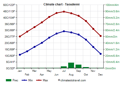
![]() Climate chart - Taoudenni
Climate chart - Taoudenni
In the extreme north-west, crossed by the Tropic of Cancer (see
Taoudenni), the climate is typical of the Sahara desert. Unlike in the central-south, where the monsoon lowers the temperature, July is the hottest month here. Also, it almost never rains, although some cloud banks can affect this area in summer, when very few downpours can occur.
Tessalit
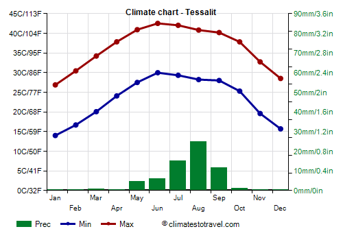
![]() Climate chart - Tessalit
Climate chart - Tessalit
More to the south, in July and August, the temperature decreases slightly because this area can be more often affected by a bit of cloudiness and some rare showers.
For example, in
Tessalit, located in the north-east, at 500 meters (1,600 feet) above sea level and 20 degrees north latitude, the average temperature in January exceeds 20 °C (68 °F). The hottest month is June.
At this latitude, we are still in the desert, but cloudiness and rare showers can arrive in summer, caused by the extreme offshoots of the African monsoon, which, however, do not show noticeable effects here.
The sun in Tessalit shines all year round, but in summer, the hours of sunshine do not increase, or decrease slightly, even though the days are a bit longer.
The center
In central Mali, the climate is
tropical semi-desert. This area, stretched from west to east south of the Sahara, is called
Sahel. The average temperature exceeds 20 °C (68 °C) even in January. In winter, the sky is usually clear, even though the wind from the north-east often blows, the
Harmattan, which can raise dust and sand, making the sky whitish.
The hottest months are April, May, and June, when the maximum temperature normally exceeds 40 °C (104 °F), but with peaks of 47/48 °C (117/118 °F).
From June to September, the monsoon comes, and is able to lower the temperature by a few degrees, and to bring some downpours, more intense and frequent than in the northern area. However, even in this period, the rains are irregular, and there are also very hot, dry periods.
After the rainy season, in September and October, the heat increases again, even though it does not reach the values of the March-May period.
Timbuktu
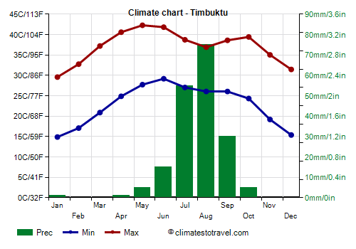
![]() Climate chart - Timbuktu
Climate chart - Timbuktu
In
Timbuktu (or Tombouctou), the legendary city of the past Mali Empire, 180 mm (7 in) of rain fall per year, almost all occurring from June to September, with a maximum of 75 mm (3 in) in August.
The source of water that made it possible for a city like Timbuktu to flourish over the past centuries were certainly not the few summer rains, but it was rather the
Niger River, whose headwaters are located in the mountains of Guinea, and which flows in this semi-desert area, then bends and returns to the south.
In Timbuktu, the sun shines all year round; however, the hours of sunshine diminish slightly in summer.

Continuing south, the summer rains become more abundant. Already in
Mopti, in the area of the "Inner Niger Delta", the rainfall amounts to 500 mm (20 in) per year.
The south
Southern Mali has a
tropical savannah climate. Rainfall exceeds 600 mm (23.5 in) per year, and in the extreme south, it even exceeds 1,000 mm (40 in).
The summer temperature is lower because of rainfall and cloud cover, in fact, highs hover around 31/32 °C (88/90 °F). In winter, in December and January, the southern sun raises the daytime temperature to around 33 °C (91 °F), even though the air is dry and nights are quite cool. The hottest months are March and April, while the temperature drops a bit already in May, owing to the first thunderstorms.
Bamako
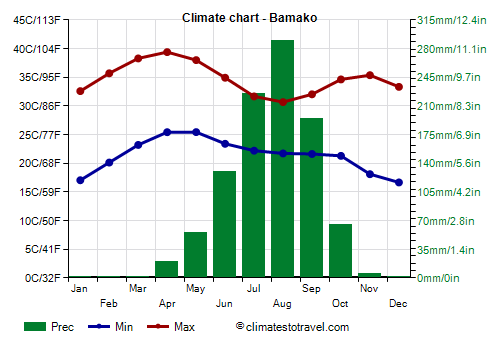
![]() Climate chart - Bamako
Climate chart - Bamako
In the capital,
Bamako, annual precipitation reaches 1,000 mm (40 in), and the rainy season is a little longer, with the first pre-monsoon showers already in May, a maximum of 300 mm (12 in) in August, and the last rains in early October. Here is the average precipitation.
In summer, the sunshine hours in Bamako diminish more than in the central areas, and August is the least sunny month.
Further south, in
Sikasso, Mali's second largest city, rainfall reaches almost 1,200 mm (47 in) per year.
When to go
The best time to visit Mali is winter, from
December to February.
By February, the heat increases and it starts to get hot in the south, while in January, sandstorms raised by the Harmattan begin to be more frequent in the north-central, so the best month overall is
December.
However, it is useful to recall that in this season, nights can be cold in the north, where the temperature may drop near freezing, while in Bamako and in the south, it can get to around 8/10 °C (46/50 °F).
What to pack
In
winter: bring light clothes for the day, long and made of natural fabric (cotton or linen), a desert turban for the wind-borne sand and dust, sunglasses (even graduated instead of contact lenses), a jacket and a sweater for the evening, desert boots or sandals, and a sweatshirt or sweater for boat trips on the Niger River.
In
summer: for the desert, bring lightweight clothes, of natural fabric (cotton or linen), a desert turban; a sweater for the night, and a sleeping bag to sleep outdoors. For Bamako and the south, light clothes, an umbrella or a light raincoat, and possibly a sweatshirt for the rain showers.
It's better for women to avoid shorts and miniskirts.
Back to topSee also the
temperatures month by month