Select units of measurement for the temperature and rainfall tables (metric or imperial).
Average weather, temperature, rainfall, sunshine
In Pakistan, the climate is
subtropical in the north, in Punjab, with moderate rainfall at the foot of the mountains, while it is
tropical desert in the center-south. In the mountains, the climate is continental up to high altitudes, and glacial on the peaks of the Himalayas.
Pakistan is an Asian country located to thre west of India (of which it once belonged), overlooking the Arabian Sea to the south and crossed, in the far north, by very high mountains (Karakoram, Hindu Kush, and Pamir), which are part of the Himalayas, and to the west, on the border with Afghanistan, by mountains of a lower height.
The climate in detail
The seasons
In
winter, from December to February, the north is reached by weather fronts of Mediterranean origin, which cause rainfall in the lowlands and snowfall in the mountains. Instead, in the central-southern part of the country, winter is a dry and sunny season. Temperatures are mild in the north and pleasantly warm in the south.
In spring (ie March and April), the clash between air masses can cause thunderstorms and strong winds.
In
summer, from July to mid September, the country is reached by an
offshoot of the Indian monsoon, but in most of the country it is not able to bring heavy rains, while it doesn't arrive at all in the western part.
However, the
hottest months are those that precede the monsoon, especially June, which is very hot in plains and hills, and up to quite high altitudes.
The
monsoon affects Pakistan only marginally, and has an
irregular pattern: during some years, it may have an unusual force, generating
floods, while in other years, it doesn't even arrive.
Rivers may overflow even at a great distance from the area where the heaviest rainfall occurred, which typically happen in the north. So, the great valley of the Indus and its tributaries may also be affected by widespread flooding in the southern area, where normally it doesn't rain much.
The cycle called
ENSO can affect the monsoon's performance: in
La Niña years, rainfall is heavier than normal, while
El Niño brings drought.
In the lowlands of Pakistan,
pollution is high, especially from October to February, and in large cities. In particular, in the north, Lahore is one of the most polluted cities in the world. In the south, Karachi is polluted even though it is on the coast, at least in winter, while from June to September, the pollution is lower because the wind comes from the sea.
Mountains
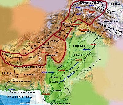
Northern mountains
In the mountainous areas of the north, the climate is
continental up to high altitudes, with a wide temperature range between winter and summer, and often also between night and day. The temperature naturally decreases with altitude.
The northern area, as well as being the coldest at equal altitude, is more prone to cold fronts brought by the westerly winds of the middle latitudes from December to May. But not all areas receive a lot of precipitation: it depends on
slope exposure. The southern side (the mountains north of Peshawar and Islamabad) is much more rainy than the northern one.
Kashmir
In
Kashmir, in the northernmost valleys of Khyber-Pakhtunkhwa and in the disputed region of Gilgit-Baltistan, yearly rainfall is at
desert levels, below 250 millimeters (10 inches). Anyway, at higher altitudes, snowfalls quite frequently occur in winter, and above 4,500 meters (14,800 ft),
vast glaciers are found
However, the fact that the trekking season runs from April to October shows how this area is sheltered from the monsoon rains, although we cannot exclude some showers or thunderstorms, and maybe snowfalls on the highest peaks.
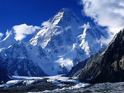
In Pakistan, there are two mountain ranges, the Karakoram and the Hindu Kush, that host some of the highest peaks on the planet, starting with
K2 (Karakorum 2), the second highest mountain in the world with its 8,611 meters (28,251 ft). The highest peak of the Hindu Kush is
Tirich Mir, 7,708 meters (25,289 ft) high.
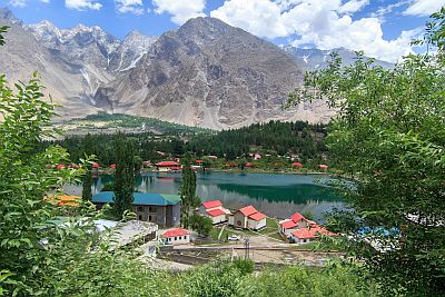 Skardu
, located at 2,200 meters (7,200 ft) above sea level, is the starting point for climbing K2 and other peaks above 8,000 meters (26,200 ft); the climate here is arid continental, with an average ranging from -2.5 °C (27.5 °F) in January to 24 °C (75 °F) in July, when the average maximum reaches 32 °C (90 °F).
Precipitation in Skardu amounts to 175 mm (7 in) per year, with a relative maximum between winter and spring.
Nearby is Lower Kachura Lake, also called
Shangri-la Lake.
Expeditions to K2 are typically organized between the second half of July and early August. K2 and other peaks over 8,000 meters (26,200 ft) have a polar climate throughout the year, with strong winds that increase the sensation of cold.
On the southern side of the mountains, in the province of
Khyber-Pakhtunkhwa (formerly North-West Frontier Province), the rains are plentiful, both those of winter and spring, which are caused by western disturbances, and those of the monsoon period, which are even heavier. Therefore, annual rainfall can exceed 1,500 mm (60 in) in the district of Abbottabad. The
Ayubia National Park is definitely green and rainy.
Southwestern mountains
In the
south-western part of Pakistan, there are other mountain ranges, such as the Chagai Hills and the Sulaiman Mountains; weather fronts in winter pass less frequently over this area, and the summer monsoon barely affects them as well.
The result is a semi-desert climate, cold in winter, at least at night and above a certain altitude, while summer is hot even at relatively high altitudes.
The plateau of
Baluchistan (or Balochistan) has an arid continental climate as well, cold in winter and hot in summer.
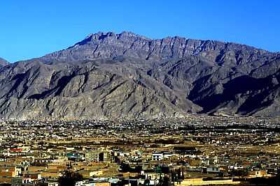
In
Quetta, 1,600 meters (5,250 feet) above sea level, the monthly average temperature ranges from 4.7 °C (40.5 °F) in January to 29.5 °C (85 °F) in July.
From December to March, the temperature at night usually drops below freezing (0 °C or 32 °F), but during the day it normally exceeds 10 °C (50 °F). Sometimes it can snow in winter, and intense frosts may occur at night, even as low as -15 °C (5 °F).
On the other hand, in the summer months, the temperature can reach 40 °C (104 °F) despite the altitude.
In Quetta, 260 mm (10.2 in) of rain or snow fall in a year, the large part of which occurring from December to March. Here, the summer monsoon produces little effects, with only sporadic rains (although it depends on the years).
Punjab
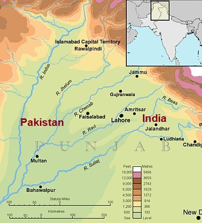
In the northern part of the Indo-Gangetic plain, corresponding to the region of
Punjab (or Panjab), the "five rivers land", there is a
sub-tropical climate.
Precipitation generally ranges from 250 to 600 mm (10 to 23.5 in) per year, but in some cases it can exceed 1,000 mm (40 in).
There is a mild, relatively rainy winter (when, however, nights are cold), followed by a spring that becomes progressively warmer, and a
very hot period from mid-April through June, when the temperature can reach 46/47 °C (115/117 °F). In spring, especially in March, tornadoes may occasionally occur because of the clash between different air masses. Before the monsoon, in May and June, a very hot wind blows, the
Loo, which can bring dust storms as well as the rapid dehydration in animals and humans, and the desiccation of vegetation. Scattered thunderstorms may occur, causing ephemeral decreases in temperature.
The
summer is sweltering, with some rain brought by the monsoon from July to September. The
monsoon arrives between late June and early July, but it's not as intense as in other regions of India, and it's characterized by periods of bad weather alternating with long weeks with intense heat and drought. However, the rains, though rare, can be violent and concentrated in few hours or even in few minutes, and when they last a few days, rivers may overflow.
In winter, in Punjab (but also in northern Sindh), mists and fogs often form.
In
Peshawar, in the northwestern region of
Khyber Pakhtunkhwa, the monthly average temperature ranges from 11 °C (52 °F) in January to 32.5 °C (90.5 °F) in June, with highs around 39 °C (102 °F). In July and August, the daytime temperature drops a bit, but at the cost of an increase in humidity. In winter, between December and February, the temperature is mild during the day, with highs around 18/20 °C (64/68 °F), but it often gets cold at night, when the temperature can drop to around freezing.
In an average year, 410 mm (16 in) of rain fall. In winter and spring, some rains may occur, with a maximum in March of 75 mm (3 in), while the summer monsoon brings a maximum of only 70 mm (2.8 in) per month in August, although the rains may be heavier during some years: in the rainiest August ever, rainfall amounted to 450 mm (17.7 in).
In
Lahore, a large metropolis in Punjab, the climate is similar to that of Peshawar, but owing to the more southern position, the winter is a bit milder: the average ranges from 12 °C (53.5 °F) in January to 32.5 °C (90.5 °F) in June.
Lying more to the east, i.e. closer to India, the city is also more exposed to the monsoon, in fact, it receives 630 mm (25 in) of rain per year, including 200 mm (8 in) in July and 165 mm (6.5 in) in August.
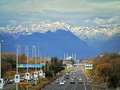
The capital of Pakistan,
Islamabad, and the neighbouring city of Rawalpindi, are located at 500 meters (1,600 feet) above sea level, and are a bit cooler, and also much more rainy, since they are located at the foot of the mountains. The average temperature in January is 10.8 °C (51.5 °F), and light frosts may sometimes occur at night. In summer, the rains lower the daytime temperatures more than in other cities, to 34/35 °C (93/95 °F) in July and August, but moisture becomes high.
In Islamabad, 1,250 mm (49 in) of rain fall per year, including more than 250 mm (10 in) per month in July and August.
Center and south
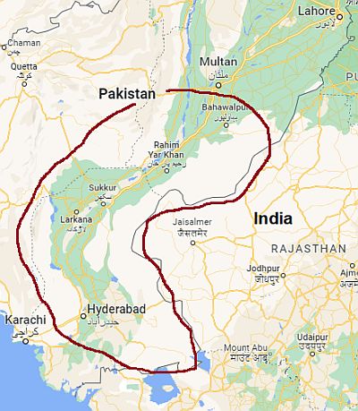
In south-central Pakistan, the climate is
subtropical desert. Winters are milder than in Punjab, and are also very dry. Precipitation is very scarce, below 200 mm (8 in) per year, and practically only occurs in summer.
The
driest part of the Indus plain is the central one, where disturbances in winter and spring are rarer, as well as the rains brought by the summer monsoon. In the eastern part of this area, we find the Cholistan Desert. Here, precipitation drops even below 100 mm (4 in) per year.
In south-central Pakistan, not too close to the sea, there is a
particularly hot area, one of the hottest in the world, which includes the north of the Sindh province (see Jacobabad, Sukkur, Larkana , Mohenjo-daro) and the lowland areas of Balochistan (see
Sibi, and Turbat in the southwest). In this area, during some years, in late May and early June, temperatures of 52/53 °C (125/127 °F) were reached.
For example, in
Jacobabad, the average maximum temperature in May and June is 44 °C (111 °F).
The effects of the monsoon are not evident, and in fact the rains are rare even in July and August, however, in this period the temperatures drop by a few degrees.
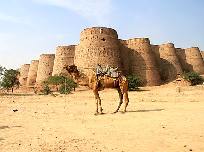
More to the south, in
Hyderabad, in the Sindh province, the winter temperatures are even milder, while in summer, they are a little lower because of the proximity to the sea. Precipitation is still scarce, and amounts to 180 mm (7 in) per year, with a maximum of 60 mm (2.4 in) per month in July and August.
South-west
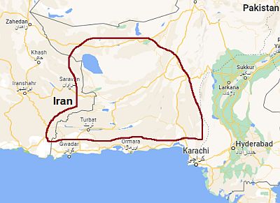
In the
south-west, at the lowest altitudes of the plateau of
Baluchistan, the climate is
subtropical desert. Winter is mild, although sometimes at night it get cold, while summer is definitely hot.
At around 800/1,000 meters (2,600/3,300 feet) above sea level (see
Panjgur), the average maximum temperatures in summer are around 40 °C (104 °F).
Only in the southern part of this area, however, there are some inland valleys around sea level: in the aforementioned city of
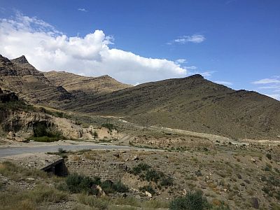
Turbat, located in the Kech River Valley, the average maximum in June is 44 °C (111 °F), which drops to 40 °C (104 °F) in July. This is a slight effect of the monsoon, which, however, brings very few rains: only 110 mm (4.3 in) per year, of which 25 mm (1 in) in July. Here the temperature reached 53.5 °C (128.3 °F) in late May 2010, one of the highest values in the world, surpassed only by Death Valley, California.
The coast
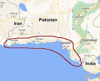
In the far south, along the
coast of the Arabian Sea, the climate is
tropical, since winter becomes milder, there is also one a reduced temperature range between winter and summer. Rainfall is at
desert or semi-desert levels; it is lower, about 100 mm (4 in) per year in the western sector (ie the coastal region of Balochistan called Makran, see
Jiwani), which receives little rainfall from the summer monsoon (but in return it receives some rare rains in winter), while it is slightly more abundant, about 200 mm (8 in) per year, at the mouth of the Indus River, where the rains basically occur only from June to September.
In
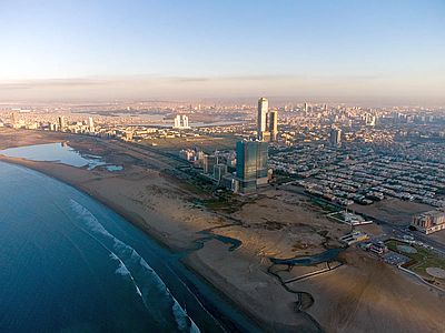
Karachi, the megalopolis located on the edge of the Indus delta, the average temperature ranges from 19 °C (66 °F) in January to 32 °C (89.5 °F) in June.
Here, winter is pleasant and sunny (although it can sometimes be cold during the night).
In the months preceding the monsoon, there can be scorchingly hot days, with peaks of 42/44 °C (108/111 °F), but it's more common for the temperature to remain about 35 °C (95 °F), though with a high humidity.
From June to September, the monsoon season, it doesn't rain a lot: about 200 mm (8 in), including 80 mm (3.2 in) in July, but here too, this season can be very rainy during certain years. In July and August, the weather is often cloudy and the heat is sweltering, especially in the interior of the city, while coastal districts receive a fairly steady breeze from the sea.
The temperature of the Arabian Sea is warm enough for swimming all year round, while it becomes very warm in summer. Here are the average sea temperatures near Karachi.
Tropical cyclones
The southern part of Pakistan can be affected by
tropical cyclones, especially the south-east (coast of Sindh): Karachi, the large city located right on the coast, is the most at risk; sometimes the coast of Makran can be interested as well, though more rarely.
Cyclones form from May to November, and are more frequent and intense at the beginning of the period
mid-May-early June) and less at the end (
October), while from July to September, when the monsoon is at the height of activity in India, they generally do not occur. In November, they typically affect the southern part of India and the Arabian Peninsula, but do not reach Pakistan.
Particularly intense cyclones hit Pakistan in May 1999 and in June 2010 (the latter was called cyclone Phet).
When to go
It is hard to find a period that fits for all of Pakistan.
The best time to visit central and southern Pakistan (where Karachi is located) is
winter, from December to February. You can visit the northernmost lowland area (Punjab, where Peshawar, Lahore and Islamabad are located) from November to March, and if you want, you can avoid the coldest months, choosing March and November.
In Quetta and in the mountain regions of the west, you can choose April and October, bearing in mind that it can get cold at night.
For the mountains of the north too, you can choose
spring and autumn, but since spring on the south side is rainy, you may prefer autumn, in particular, October and November. For the north side, in the high mountain areas of the Hindu Kush and the Karakoram, you may prefer the summer, from June to September.
As previously mentioned, the
sea is warm enough to swim in throughout the year. However, given that the air temperature can be a bit cool from December to February, the best months to go to the beach are March and November.
What to pack
In
winter: for the north at low altitude (Lahore, Peshawar, Islamabad and Rawalpindi), bring spring/autumn clothes, a sweater and a warm jacket for the evening; a raincoat or umbrella especially in Islamabad and Rawalpindi. Above a thousand meters (3,300 feet, see Abbottabad), bring warm clothes, such as a sweater, a warm jacket, and a raincoat or umbrella. In Kashmir, above 3,000 meters (9,800 ft), bring mountain clothes, a down jacket, a hat, a scarf, and gloves. In the center and south (Jacobabad, Sukkur, Hyderabad), spring/autumn clothes, a sweater and a jacket for the evening. On the southern coast (Karachi), spring/autumn clothes (light for the day), a light jacket and a sweater for the evening. For Quetta and the western mountains, around 1,500 meters (5,000 feet), warm clothes, such as a sweater, a down jacket, and a hat.
In
summer: for all areas at low altitude, from Islamabad to Karachi, bring tropics-friendly, loose-fitting clothing, a sun hat, a desert turban, and possibly a light raincoat or umbrella, which are more useful in the north, at the foot of the mountains. Above 1,000 meters (3,300 feet, see Quetta, Abbottabad), add a sweatshirt for the evening. For Kashmir, around 3,000 meters (9,800 ft), bring spring/autumn clothes (light for the day), a sun hat, sunglasses, a sweater and a jacket for the evening; for higher altitudes, warmer clothes depending on altitude.
It's better for women to avoid low-cut dresses.
When visiting mosques, men must keep their shoulders and knees covered, and take off their shoes, while women should also cover their hair.
Climate data - Pakistan
| Dera Ismail Khan |
|---|
Dera Ismail Khan, location on the map |
|---|
| Jan | Feb | Mar | Apr | May | Jun | Jul | Aug | Sep | Oct | Nov | Dec |
|---|
| Min temp. | 6 | 9 | 14 | 19 | 24 | 27 | 27 | 27 | 25 | 19 | 12 | 7 |
|---|
| Max temp. | 19 | 22 | 27 | 33 | 39 | 40 | 38 | 37 | 36 | 33 | 27 | 21 |
|---|
| Precip. | 10 | 15 | 35 | 20 | 15 | 15 | 60 | 55 | 20 | 5 | 0 | 10 |
|---|
| Prec. days | 3 | 4 | 7 | 5 | 3 | 2 | 5 | 5 | 2 | 1 | 1 | 2 |
|---|
| Humidity | 67% | 63% | 63% | 52% | 42% | 50% | 66% | 70% | 66% | 60% | 65% | 68% |
|---|
| Day length | 10 | 11 | 12 | 13 | 14 | 14 | 14 | 13 | 12 | 11 | 10 | 10 |
|---|
| Sun hours | 7 | 7 | 8 | 9 | 9 | 8 | 8 | 8 | 9 | 9 | 8 | 7 |
|---|
|
| Hyderabad |
|---|
Hyderabad, location on the map |
|---|
| Jan | Feb | Mar | Apr | May | Jun | Jul | Aug | Sep | Oct | Nov | Dec |
|---|
| Min temp. | 12 | 14 | 19 | 23 | 26 | 28 | 28 | 27 | 25 | 23 | 18 | 13 |
|---|
| Max temp. | 24 | 28 | 33 | 39 | 41 | 40 | 37 | 36 | 36 | 36 | 31 | 25 |
|---|
| Precip. | 0 | 5 | 5 | 5 | 5 | 15 | 55 | 60 | 20 | 0 | 0 | 0 |
|---|
| Prec. days | 0 | 1 | 0 | 0 | 0 | 1 | 2 | 3 | 1 | 0 | 0 | 0 |
|---|
| Humidity | 51% | 44% | 41% | 41% | 50% | 58% | 65% | 69% | 65% | 49% | 45% | 50% |
|---|
| Day length | 11 | 11 | 12 | 13 | 13 | 14 | 14 | 13 | 12 | 12 | 11 | 11 |
|---|
| Sun hours | 9 | 9 | 9 | 10 | 10 | 9 | 8 | 8 | 10 | 10 | 9 | 9 |
|---|
|
| Islamabad (500 meters) |
|---|
Islamabad, location on the map |
|---|
| Jan | Feb | Mar | Apr | May | Jun | Jul | Aug | Sep | Oct | Nov | Dec |
|---|
| Min temp. | 4 | 7 | 12 | 16 | 21 | 24 | 25 | 24 | 22 | 16 | 9 | 5 |
|---|
| Max temp. | 18 | 20 | 25 | 31 | 36 | 38 | 35 | 34 | 33 | 30 | 25 | 20 |
|---|
| Precip. | 65 | 95 | 110 | 80 | 55 | 80 | 275 | 290 | 100 | 35 | 25 | 45 |
|---|
| Prec. days | 5 | 7 | 10 | 10 | 8 | 8 | 16 | 16 | 9 | 4 | 3 | 4 |
|---|
| Humidity | 66% | 63% | 57% | 49% | 40% | 45% | 66% | 73% | 66% | 58% | 61% | 65% |
|---|
| Day length | 10 | 11 | 12 | 13 | 14 | 14 | 14 | 13 | 12 | 11 | 10 | 10 |
|---|
| Sun hours | 6 | 7 | 7 | 8 | 10 | 10 | 9 | 8 | 9 | 9 | 8 | 6 |
|---|
|
| Jacobabad |
|---|
Jacobabad, location on the map |
|---|
| Jan | Feb | Mar | Apr | May | Jun | Jul | Aug | Sep | Oct | Nov | Dec |
|---|
| Min temp. | 8 | 12 | 17 | 23 | 29 | 30 | 30 | 29 | 27 | 22 | 16 | 10 |
|---|
| Max temp. | 21 | 25 | 31 | 37 | 44 | 44 | 40 | 37 | 36 | 34 | 29 | 23 |
|---|
| Precip. | 5 | 5 | 10 | 0 | 0 | 5 | 35 | 25 | 10 | 0 | 0 | 5 |
|---|
| Prec. days | 0 | 1 | 1 | 1 | 1 | 0 | 2 | 1 | 1 | 0 | 0 | 0 |
|---|
| Humidity | 62% | 54% | 52% | 41% | 33% | 43% | 59% | 66% | 66% | 60% | 59% | 62% |
|---|
| Day length | 11 | 11 | 12 | 13 | 14 | 14 | 14 | 13 | 12 | 12 | 11 | 10 |
|---|
| Sun hours | 8 | 8 | 8 | 8 | 9 | 9 | 8 | 8 | 9 | 9 | 9 | 8 |
|---|
|
| Jiwani |
|---|
Jiwani, location on the map |
|---|
| Jan | Feb | Mar | Apr | May | Jun | Jul | Aug | Sep | Oct | Nov | Dec |
|---|
| Min temp. | 15 | 16 | 20 | 23 | 26 | 27 | 27 | 26 | 25 | 24 | 20 | 16 |
|---|
| Max temp. | 24 | 26 | 29 | 32 | 35 | 34 | 32 | 32 | 32 | 33 | 30 | 26 |
|---|
| Precip. | 25 | 35 | 10 | 5 | 0 | 0 | 10 | 5 | 0 | 0 | 5 | 20 |
|---|
| Prec. days | 1 | 1 | 1 | 1 | 0 | 0 | 0 | 0 | 0 | 0 | 0 | 1 |
|---|
| Humidity | 59% | 60% | 64% | 64% | 68% | 73% | 75% | 76% | 74% | 68% | 58% | 57% |
|---|
| Day length | 11 | 11 | 12 | 13 | 13 | 14 | 14 | 13 | 12 | 12 | 11 | 11 |
|---|
| Sun hours | 9 | 9 | 9 | 10 | 11 | 9 | 7 | 7 | 8 | 10 | 10 | 9 |
|---|
| Sea temp | 24 | 23 | 24 | 26 | 29 | 30 | 30 | 29 | 28 | 28 | 27 | 25 |
|---|
| Karachi |
|---|
Karachi, location on the map |
|---|
| Jan | Feb | Mar | Apr | May | Jun | Jul | Aug | Sep | Oct | Nov | Dec |
|---|
| Min temp. | 12 | 15 | 20 | 24 | 27 | 29 | 28 | 27 | 26 | 23 | 18 | 13 |
|---|
| Max temp. | 26 | 29 | 32 | 35 | 36 | 36 | 34 | 32 | 33 | 35 | 32 | 28 |
|---|
| Precip. | 5 | 10 | 10 | 5 | 0 | 5 | 80 | 55 | 20 | 0 | 0 | 5 |
|---|
| Prec. days | 0 | 1 | 0 | 0 | 0 | 1 | 3 | 2 | 1 | 0 | 0 | 1 |
|---|
| Humidity | 46% | 46% | 49% | 55% | 63% | 67% | 71% | 72% | 68% | 54% | 46% | 45% |
|---|
| Day length | 11 | 11 | 12 | 13 | 13 | 14 | 14 | 13 | 12 | 12 | 11 | 11 |
|---|
| Sun hours | 9 | 9 | 9 | 9 | 10 | 8 | 5 | 5 | 7 | 9 | 9 | 9 |
|---|
| Sea temp | 24 | 23 | 24 | 26 | 28 | 29 | 29 | 28 | 28 | 28 | 27 | 25 |
|---|
| Lahore (220 meters) |
|---|
Lahore, location on the map |
|---|
| Jan | Feb | Mar | Apr | May | Jun | Jul | Aug | Sep | Oct | Nov | Dec |
|---|
| Min temp. | 6 | 10 | 14 | 19 | 25 | 27 | 27 | 26 | 24 | 19 | 12 | 7 |
|---|
| Max temp. | 18 | 22 | 28 | 34 | 39 | 39 | 35 | 34 | 34 | 32 | 27 | 21 |
|---|
| Precip. | 25 | 30 | 40 | 20 | 20 | 35 | 200 | 165 | 60 | 10 | 5 | 15 |
|---|
| Prec. days | 4 | 5 | 6 | 5 | 5 | 5 | 11 | 11 | 5 | 2 | 2 | 3 |
|---|
| Humidity | 67% | 61% | 55% | 43% | 36% | 48% | 70% | 73% | 69% | 58% | 59% | 64% |
|---|
| Day length | 10 | 11 | 12 | 13 | 14 | 14 | 14 | 13 | 12 | 11 | 10 | 10 |
|---|
| Sun hours | 7 | 8 | 8 | 9 | 10 | 9 | 7 | 8 | 9 | 9 | 9 | 7 |
|---|
|
| Multan |
|---|
Multan, location on the map |
|---|
| Jan | Feb | Mar | Apr | May | Jun | Jul | Aug | Sep | Oct | Nov | Dec |
|---|
| Min temp. | 6 | 10 | 15 | 19 | 26 | 29 | 29 | 28 | 26 | 20 | 13 | 8 |
|---|
| Max temp. | 20 | 23 | 29 | 34 | 41 | 41 | 39 | 37 | 36 | 33 | 28 | 22 |
|---|
| Precip. | 5 | 10 | 20 | 15 | 10 | 10 | 60 | 35 | 10 | 0 | 0 | 5 |
|---|
| Prec. days | 2 | 3 | 5 | 4 | 3 | 2 | 5 | 4 | 2 | 1 | 1 | 1 |
|---|
| Humidity | 68% | 62% | 56% | 48% | 35% | 45% | 58% | 64% | 62% | 57% | 62% | 68% |
|---|
| Day length | 10 | 11 | 12 | 13 | 14 | 14 | 14 | 13 | 12 | 11 | 11 | 10 |
|---|
| Sun hours | 7 | 8 | 8 | 9 | 9 | 9 | 9 | 9 | 9 | 9 | 8 | 7 |
|---|
|
| Nawabshah |
|---|
Nawabshah, location on the map |
|---|
| Jan | Feb | Mar | Apr | May | Jun | Jul | Aug | Sep | Oct | Nov | Dec |
|---|
| Min temp. | 7 | 10 | 16 | 21 | 25 | 28 | 28 | 27 | 25 | 20 | 14 | 9 |
|---|
| Max temp. | 24 | 28 | 34 | 40 | 44 | 43 | 41 | 39 | 39 | 38 | 32 | 26 |
|---|
| Precip. | 0 | 0 | 5 | 5 | 0 | 10 | 50 | 45 | 10 | 5 | 0 | 5 |
|---|
| Prec. days | 0 | 0 | 0 | 0 | 0 | 1 | 2 | 2 | 1 | 0 | 0 | 0 |
|---|
| Humidity | 60% | 54% | 47% | 39% | 39% | 48% | 57% | 61% | 59% | 52% | 55% | 59% |
|---|
| Day length | 11 | 11 | 12 | 13 | 14 | 14 | 14 | 13 | 12 | 12 | 11 | 10 |
|---|
|
|
| Panjgur (1,000 meters) |
|---|
Panjgur, location on the map |
|---|
| Jan | Feb | Mar | Apr | May | Jun | Jul | Aug | Sep | Oct | Nov | Dec |
|---|
| Min temp. | 4 | 7 | 12 | 18 | 23 | 25 | 26 | 24 | 21 | 16 | 10 | 5 |
|---|
| Max temp. | 18 | 21 | 27 | 33 | 38 | 40 | 40 | 38 | 35 | 31 | 25 | 20 |
|---|
| Precip. | 15 | 15 | 15 | 10 | 5 | 5 | 25 | 10 | 0 | 0 | 0 | 10 |
|---|
| Prec. days | 2 | 1 | 1 | 1 | 1 | 0 | 2 | 1 | 0 | 0 | 0 | 1 |
|---|
| Humidity | 46% | 43% | 39% | 32% | 31% | 29% | 35% | 35% | 29% | 29% | 36% | 41% |
|---|
| Day length | 11 | 11 | 12 | 13 | 14 | 14 | 14 | 13 | 12 | 12 | 11 | 10 |
|---|
|
|
| Peshawar (330 meters) |
|---|
Peshawar, location on the map |
|---|
| Jan | Feb | Mar | Apr | May | Jun | Jul | Aug | Sep | Oct | Nov | Dec |
|---|
| Min temp. | 5 | 8 | 13 | 17 | 22 | 26 | 27 | 26 | 23 | 17 | 11 | 6 |
|---|
| Max temp. | 18 | 20 | 25 | 30 | 36 | 39 | 37 | 35 | 34 | 30 | 24 | 20 |
|---|
| Precip. | 30 | 45 | 75 | 50 | 25 | 10 | 45 | 70 | 20 | 10 | 15 | 25 |
|---|
| Prec. days | 5 | 7 | 11 | 10 | 7 | 4 | 8 | 9 | 5 | 4 | 3 | 4 |
|---|
| Humidity | 64% | 62% | 62% | 55% | 45% | 45% | 61% | 68% | 63% | 61% | 64% | 64% |
|---|
| Day length | 10 | 11 | 12 | 13 | 14 | 14 | 14 | 13 | 12 | 11 | 10 | 10 |
|---|
| Sun hours | 6 | 7 | 6 | 8 | 10 | 10 | 9 | 8 | 9 | 9 | 8 | 6 |
|---|
|
| Quetta (1,650 meters) |
|---|
Quetta, location on the map |
|---|
| Jan | Feb | Mar | Apr | May | Jun | Jul | Aug | Sep | Oct | Nov | Dec |
|---|
| Min temp. | -2 | 1 | 6 | 10 | 15 | 20 | 23 | 21 | 15 | 8 | 3 | -1 |
|---|
| Max temp. | 11 | 14 | 19 | 25 | 31 | 35 | 36 | 35 | 31 | 25 | 19 | 13 |
|---|
| Precip. | 50 | 45 | 50 | 30 | 10 | 5 | 15 | 15 | 0 | 5 | 5 | 30 |
|---|
| Prec. days | 4 | 5 | 6 | 5 | 4 | 2 | 5 | 4 | 2 | 2 | 1 | 3 |
|---|
| Humidity | 58% | 55% | 52% | 45% | 34% | 30% | 34% | 34% | 34% | 36% | 44% | 51% |
|---|
| Day length | 10 | 11 | 12 | 13 | 14 | 14 | 14 | 13 | 12 | 11 | 11 | 10 |
|---|
| Sun hours | 7 | 7 | 8 | 9 | 11 | 11 | 10 | 10 | 10 | 10 | 9 | 8 |
|---|
|
| Sargodha |
|---|
Sargodha, location on the map |
|---|
| Jan | Feb | Mar | Apr | May | Jun | Jul | Aug | Sep | Oct | Nov | Dec |
|---|
| Min temp. | 5 | 9 | 14 | 19 | 25 | 28 | 28 | 27 | 25 | 19 | 12 | 7 |
|---|
| Max temp. | 18 | 22 | 26 | 32 | 39 | 40 | 37 | 36 | 35 | 32 | 26 | 21 |
|---|
| Precip. | 20 | 20 | 30 | 25 | 25 | 25 | 115 | 120 | 35 | 15 | 5 | 15 |
|---|
| Prec. days | 4 | 6 | 8 | 7 | 6 | 5 | 11 | 11 | 5 | 2 | 2 | 3 |
|---|
| Humidity | 68% | 64% | 58% | 50% | 40% | 46% | 63% | 68% | 65% | 60% | 66% | 65% |
|---|
| Day length | 10 | 11 | 12 | 13 | 14 | 14 | 14 | 13 | 12 | 11 | 10 | 10 |
|---|
|
|
| Sibi |
|---|
Sibi, location on the map |
|---|
| Jan | Feb | Mar | Apr | May | Jun | Jul | Aug | Sep | Oct | Nov | Dec |
|---|
| Min temp. | 7 | 11 | 17 | 22 | 28 | 31 | 30 | 29 | 27 | 21 | 14 | 8 |
|---|
| Max temp. | 22 | 25 | 30 | 36 | 43 | 44 | 42 | 40 | 39 | 36 | 30 | 24 |
|---|
| Precip. | 15 | 10 | 15 | 5 | 0 | 5 | 35 | 20 | 10 | 0 | 5 | 5 |
|---|
| Prec. days | 1 | 1 | 2 | 1 | 0 | 0 | 2 | 1 | 0 | 0 | 0 | 0 |
|---|
| Humidity | 56% | 52% | 50% | 45% | 36% | 44% | 54% | 61% | 55% | 46% | 51% | 54% |
|---|
| Day length | 10 | 10 | 11 | 12 | 13 | 14 | 14 | 14 | 13 | 12 | 11 | 11 |
|---|
|
|
| Skardu (2,180 meters) |
|---|
Skardu, location on the map |
|---|
| Jan | Feb | Mar | Apr | May | Jun | Jul | Aug | Sep | Oct | Nov | Dec |
|---|
| Min temp. | -8 | -4 | 2 | 7 | 10 | 13 | 16 | 16 | 11 | 4 | -2 | -6 |
|---|
| Max temp. | 3 | 6 | 12 | 19 | 23 | 29 | 32 | 31 | 27 | 20 | 13 | 6 |
|---|
| Precip. | 30 | 25 | 35 | 30 | 25 | 10 | 10 | 10 | 10 | 5 | 5 | 15 |
|---|
|
|
|
|
|
| Turbat |
|---|
Turbat, location on the map |
|---|
| Jan | Feb | Mar | Apr | May | Jun | Jul | Aug | Sep | Oct | Nov | Dec |
|---|
| Min temp. | 11 | 12 | 16 | 21 | 26 | 28 | 27 | 26 | 24 | 20 | 16 | 12 |
|---|
| Max temp. | 25 | 27 | 33 | 38 | 43 | 44 | 40 | 40 | 39 | 38 | 32 | 27 |
|---|
|
|
|
|
|
See also the
temperatures month by month