Select units of measurement for the temperature and rainfall tables (metric or imperial).
Average weather, temperature, rainfall, sunshine hours
The climate of Skardu is
arid continental, with cold winters and hot summers.
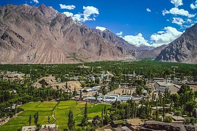
Skardu is a town of 30,000 inhabitants located in the far north of Pakistan, on the banks of the Indus River, in the territory of
Gilgit-Baltistan, at 2,200 meters (7,200 feet) above sea level and 35 degrees north latitude.
Together with the town of Gilgit, which is located 130 km (80 mi) northwest and at a lower altitude (1,500 meters or 4,900 feet), it is the starting point for climbing some of the highest
mountains in the world, which are located in the area: K2, Broad Peak, Gasherbrum I, Nanga Parbat, and Gashebrum-II. The tourist season runs from April to October.
About 20 km (12 mi) northwest is the Lower Kachura Lake, also called
Shangrila Lake.
To the south, on a plateau at almost 4,000 meters (13,000 ft) above sea level, is the
Deosai National Park.
 Precipitation
 is scarce, and occurs mostly from December to May, caused by disturbances that pass in winter (when it can occur in the form of
snow) and by the clashes of air masses typical of spring.
We are on a
desert plateau, bordered by the Karakorum mountain ranges to the north and the Himalayas to the south, which make the climate arid. In particular, in summer, the monsoon practically does not arrive, because the humid winds from the Indian plain discharge on the southern slope of the Himalayas.
In winter, during
cold spells, the temperature can drop below -15 °C (5 °F). From 1961 to 2009, the cold record was -24 °C (-11 °F), set in January 1995.
In summer, there can be
very hot periods, during which the temperature exceeds 35 °C (95 °F). From 1961 to 2009, the heat record was 41 °C (106 °F), set in August 1990.
Skardu - Climate data
In Skardu, the
average temperature of the coldest month (January) is of
-2.4 °C, that of the warmest month (July) is of
24 °C. Here are the average temperatures.
Skardu - Average temperatures (1961-2009) |
| Month | Min | Max | Mean |
|---|
| January | -8 | 3.2 | -2.4 |
|---|
| February | -4.4 | 6.1 | 0.8 |
|---|
| March | 1.5 | 12.4 | 7 |
|---|
| April | 6.6 | 18.8 | 12.7 |
|---|
| May | 9.7 | 23.4 | 16.5 |
|---|
| June | 13.4 | 28.7 | 21 |
|---|
| July | 16.4 | 31.6 | 24 |
|---|
| August | 16 | 31.2 | 23.6 |
|---|
| September | 11.4 | 27.2 | 19.3 |
|---|
| October | 4.3 | 20.4 | 12.4 |
|---|
| November | -1.9 | 13.2 | 5.6 |
|---|
| December | -5.6 | 6.5 | 0.5 |
|---|
| Year | 5 | 18.6 | 11.8 |
|---|
amounts to
175 millimeters per year: it is therefore at a desert level. It ranges from
5.6 millimeters in the driest month (November) to
36.9 millimeters in the wettest one (March). Here is the average precipitation.
Skardu - Average precipitation| Month | Days |
|---|
| January | 28 | |
|---|
| February | 26 | |
|---|
| March | 37 | |
|---|
| April | 31 | |
|---|
| May | 25 | |
|---|
| June | 9 | |
|---|
| July | 10 | |
|---|
| August | 12 | |
|---|
| September | 9 | |
|---|
| October | 7 | |
|---|
| November | 6 | |
|---|
| December | 16 | |
|---|
| Year | 175 | |
|---|