Select units of measurement for the temperature and rainfall tables (metric or imperial).
Average weather, temperature, rainfall, sunshine
In Tanzania, there is a
subtropical or tropical climate on the plateau, not too hot because of altitude.
On the contrary, the thin
coastal stretch is hot and humid throughout the year, especially from November to April.
The
rains vary in intensity and distribution according to the zones, in fact, in some areas there is a single rainy season from December to April, while in others there are two rainy seasons in spring and autumn.
The June-August period (
kipupwe), the austral winter, is the coolest of the year, and is dry almost everywhere.
Tanzania is a big African country which overlooks the Indian Ocean and lies just south of the Equator. Much of the country is covered by a
plateau, where a large number of world-famous tourist attractions are found, in particular, the savannah environment with its characteristic flora and fauna, preserved in various parks and nature reserves.
The climate in detail
The seasons
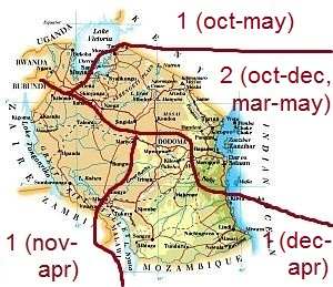
As regards to the rain pattern, the country can be divided into
four zones.
In the north and the east, except in the region of Lake Victoria, there are
two rainy seasons: one less intense, known as
short rains season (
vuli), between October and December, and the other more intense, known as
long rains season (
masika), from March to May, with a peak in April. In January and February, in the period between the two rainy seasons (
kiangazi), the weather is hot and sultry, at least below a thousand meters (3,300 feet).
In the far north-west, the two rainy seasons are practically connected, in fact, it rains even in January and February, when rainfall amounts to 100/150 millimeters (4/6 inches) per month depending on the area; therefore, in this region, there is practically
a single rainy season from October to May. Such a situation is also found in a few areas of the north-east, in particular, along the southern slopes of Mount Kilimanjaro.
In the center and south, there's only one rainy season,
from December to April in the south and south-east, and
from November to April in the west.
The division of the country according to the rainy seasons is indicated in the following map, where we can sea the areas where there are one or two rainy seasons, and the months when they occur.
The tropical rains occur mainly in the form of downpours or thunderstorms in the afternoon, so in the morning the sky is often clear even during the rainy periods.
The coast
On the coast, the climate is hot all year round, with two rainy seasons in the northern part, and only one in the southern part.
Dar Es Salaam
 Dar Es Salaam
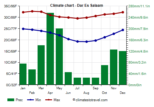
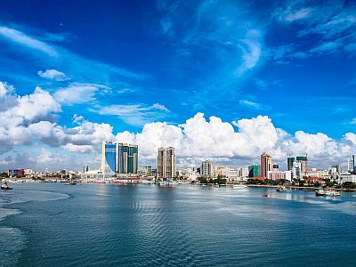
, the largest city and the former capital of Tanzania, is located on the coast, in the area with two rainy seasons, and it's hot all year round, with a slightly hotter and wetter period from November to April, when daytime temperatures are around 32/33 °C (90/91 °F), but with peaks of 35/36 °C (95/97 °F). Relative humidity is high, especially in March and April, the rainiest months.
In Dar Es Salaam, annual precipitation amounts to 1,150 mm (45 in), with a maximum from March to May; April is the rainiest month with 255 mm (10 in). There is also a secondary maximum, that of the short rains, from October to December. However, the rainfall pattern is quite irregular, in fact, during some years, the short rains period can be very rainy as well.
From June to September, there is little rain; this period, in addition to being the driest, is also the coolest, with highs around 30 °C (86 °F) and lows around 19/20 °C (66/68 °F), though the night temperature can sometimes drop to around 15 °C (59 °F).
The amount of sunshine in Dar Es Salaam is good throughout the year, except maybe in April, the wettest month.
The
sea in Dar es Salaam (as in the rest of Tanzania) is always warm enough for swimming: the water temperature ranges from 25.5 °C (78 °F) in August to 29.5 °C (85 °F) in the summer months.
Both the climate and the rain pattern are similar in the
Zanzibar Archipelago, where, however, it rains more: about 1,600 mm (63 in) per year in Zanzibar, and up to 1,900 mm (75 in) on the northern island of Pemba.
The plateau
On the
plateau, temperatures vary with altitude, though they are usually mild or warm without excesses for most of the year. The amount of rainfall tends to increase with altitude, but it also depends on slope exposure and the proximity to the highest mountains, so there are more or less rainy areas.
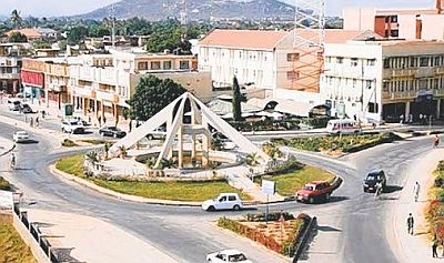
Dodoma
 Dodoma
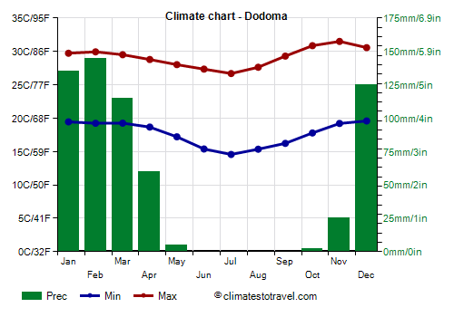
, the capital of Tanzania, is located at 1,100 meters (3,600 feet) above sea level, in an inland dry area, and has a single rainy season. In an average year, only 600 mm (23.5 in) of rain fall, most of which occur from December to mid-April, while it almost never rains from May to October.
In October and November, before the rains, it can get hot, but peaks around 35 °C (95 °F) are possible until February.
So, the best time here is from May to September, when the temperature is about 27/29 °C (81/84 °F) during the day and about 15 °C (59 °F) at night; sometimes, there can be a few colder nights, around 12 °C (54 °F).
In
Iringa, the climate is similar, but it is a bit cooler, since the city is located at 1,400 meters (4,600 feet) above sea level, and therefore it's never excessively hot, while it can be a bit cold at night, especially from May to September.
Kilimanjaro
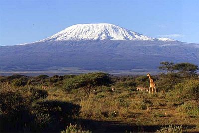
In the north-east, in the area with two rainy seasons, we find a series of towering mountains, including
Kilimanjaro volcano, 5,895 meters (19,340 feet) high, which is also the highest mountain in Africa, and has permanent snow above 5,000 meters (16,400 ft), unfortunately in retreat because of global warming.
On the slopes, there are
different climates and biomes depending on altitude. At low altitudes we find the savannah. Between 1,800 and 2,800 meters (5,900 and 9,200 ft), we find the rainforest. Between 2,800 and 4,000 meters (9,200 and 13,100 ft), where at night the temperature can drop below freezing (0 °C or 32 °F), a dry mountain vegetation.
Between 4,000 and 5,000 meters (13,000 and 16,500 ft), a
cold desert, where, however, during the day the equatorial sun of high altitude is very strong, and it's able to considerably warm up the bare rocks, while at night, it gets very cold. Above 5,000 meters (16,500 ft), we find a
polar climate. On the summit, which is often above the cloud layer, the average temperature is -7 °C (19.5 °F), but in the coldest nights it can drop to -15/-25 °C (5/-13 °F). On the summit, snowfall can occur all year round, but especially in the two rainy periods.
Considering both temperature (which is higher in January and February, and lower from June to August) and precipitation (which is higher from March to May, and lower from July to September), it's generally preferable to climb the mountain in
January, February and September, while the worst months are April and May because of high rainfall (and even snowfall at high elevations) and frequent cloudiness. Some visitors choose the days of
full moon, a phenomenon that occurs roughly once per month, during which the glaciers lit by the moon offer a wonderful view at night.
West of Kilimangiaro, we find another mountain, Meru volcano, 4,565 meters (14,977 feet) high.
Arusha
At the foot of Mount Meru, at 1,400 meters (4,600 feet) of altitude, we find the city of
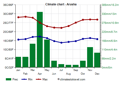
Arusha. Here, the temperature is pleasant all year round, in fact, the daily average ranges from 21/22 °C (71/72 °F) between January and April to 18/19 °C (64/65 °F) in June and July. Sometimes, however, between November and March, it can get hot during the day. Nights are cool throughout the year, especially from June to September, when lows can drop to 10 °C (50 °F), while during the day, the temperature fluctuates around 22/23 °C (72/73 °F).
Rainfall in Arusha amounts to 1,100 mm (43 in) per year.
In Arusha, the amount of sunshine, good most of the year, decreases slightly in the rainiest months, but it does not increase much in the coolest and driest months, i.e. June and July.

The
Serengeti National Park is located north-west of Arusha, towards Lake Victoria and the border with Kenya; here, the altitude varies between 1,100 and 2,000 meters (3,600/6,600 feet). This is the area of the savanna, a kind of grassland which becomes greener and higher in the rainy season, with rare trees such as the huge baobabs, and animals such as rhinos, hippos, giraffes, elephants, lions, cheetahs, and leopards. The driest part of the Serengeti, where trees are a rarity, is the south-eastern one.
The
Olduvai Gorge, the cradle of humankind, where fossil remains of early hominids were found, is located between the Serengeti and the Ngorongoro Conservation Area, at 1,400 meters (4,600 feet) above sea level. Here, the climate is more arid.
On the contrary, the
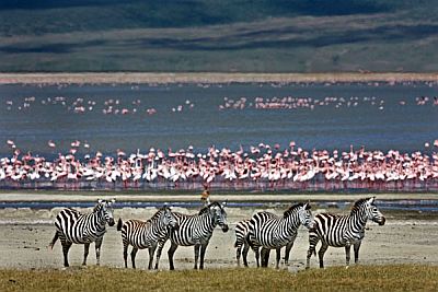
Ngorongoro Conservation Area is rainier, at least in the highest areas, which exceed 2,000 meters (6,500 feet). In the city of the same name, which lies at 2,400 meters (7,900 ft), the weather is spring-like all year round, with cool nights, sometimes even a bit cold, while during the day it is pleasantly warm from October to March, and mild from May to September. Here, as in the far north-west, thunderstorms can sometimes occur even in the dry season, in January and February.
In Tanzania, there are several large lakes.
Lake Victoria
The huge
Lake Victoria is located in the north-west, at 1,100 meters (3,600 feet) above sea level. Here, the climate is warm all year round.
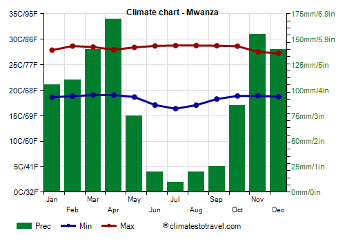
In
Mwanza, highs range from 27 °C (80.5 °F) in December to 29 °C (84 °F) in the June-September period.
Precipitation is more abundant on the western side of the lake (see
Bukoba) than on the eastern side (see
Musoma). In Mwanza, which is located on the southern side, it is at an intermediate level, and amounts to 1,050 mm (41 in) per year. We are in the area with a single rainy season, from October to May.
Further south,
Lake Tanganyika (see
Kigoma), along the
Rift Valley, is located at 770 meters (2,500 feet) above sea level, while even more to the south,
Lake Malawi is at 480 meters (1,570 feet), so along its banks the weather is hotter because of the lower altitude. There are several national parks and nature reserves in the center-south as well.
Tropical cyclones
The central and southern part of Tanzania are located just south of the Equator, at the edge of the area where tropical cyclones can form; while the northern part of the coast (see Dar Es Salaam, Zanzibar) is hardly ever affected, the south-eastern provinces (see Lindi,
Mtwara) may be affected, usually marginally, by cyclones passing over the area of Comoros and Mayotte. Cyclones of the South-West Indian Ocean are formed from November to mid-May, but more frequently from late December to mid-April.
When to go
The best time to visit Tanzania as a whole runs from
July to August, since it is the coolest, the sunniest and driest of the year.
June is a good month almost everywhere, but in the north-east and on the island of Pemba, the long rains can linger until this month.
September is also a good month, but at lower elevations it can be hot during the day.
In October, the season of the short rains begins in the north, though there is usually little rain in the first half of the month, however, it can get hot at low altitudes.
In January, the south is in full rainy season, so it rains a lot. If you want to visit the country in the Northern Hemisphere winter (
January and February), you can choose the northern areas, which, in this period, are in the short and hot dry season, remembering that on the coast and at lower altitudes it's hot, and that some showers in the afternoon may still occur, especially on the shores of Lake Victoria and in high mountains like Kilimanjaro.
In the
Serengeti, you can go from June to September, with a preference for June, in the period of the wildebeest migration through the rivers, before the animals move to Kenya, or even in January and February, to watch them in the southern part, towards the Olduvai Gorge.
What to pack
In
inland areas, in general, it's better to dress in layers, and to bring warmer clothes at high altitudes, and lighter at low altitudes and in the warm season. You can also bring a sun hat and sunscreen, and a raincoat for the rain showers in the rainy periods. In parks and reserves, bring neutral-colored clothes, and comfortable canvas shoes.
When going
mountain climbing, bring hiking shoes. For the summit of Kilimanjaro, throughout the year, bring cold weather clothing, synthetic, thermal long underwear, a fleece, a parka, a wind jacket, warm boots, sunglasses,and sunscreen.
When going to the reef, you can bring snorkeling equipment, including water shoes or rubber-soled shoes.
In
winter (June to August): on the coast (Dar es Salaam, Zanzibar), bring light clothing, a sweatshirt for the evening, a light scarf for the breeze. On the shores of lakes Malawi and Tanganyika, light clothing, a sweatshirt and a light jacket, and a light scarf for the breeze. In Arusha, Dodoma, the Serengeti and Lake Victoria, light clothes for the day, a sweater and a jacket for the evening. In Ngorongoro and the plateau above 2,000 meters (6,500 feet), spring/autumn clothes, with a jacket and a sweater; above 3,000 meters (9,800 ft), a warm jacket and a hat.
In
summer (December to February): on the coast (Dar es Salaam, Zanzibar), bring light clothing, made of natural fibers, a light sweatshirt for the evening, and a light raincoat or umbrella, especially in the south (see Mtwara). In Dodoma, and on the shores of lakes Malawi, Tanganyika and Victoria, light clothing, made of natural fibers, a sun hat, a light sweatshirt for the evening, and a light raincoat or umbrella. In Arusha, the Serengeti and the plateau at intermediate altitudes, you can add a jacket and a sweater for the evening. In Ngorongoro and the plateau above 2,000 meters (6,500 feet), spring/autumn clothes, with a jacket and a sweater, and a raincoat or umbrella; above 3,000 meters (9,800 ft), a down jacket and a hat.
Climate data - Tanzania
| Arusha (1,350 meters) |
|---|
|
| Jan | Feb | Mar | Apr | May | Jun | Jul | Aug | Sep | Oct | Nov | Dec |
|---|
| Min temp. | 16 | 16 | 17 | 17 | 16 | 15 | 14 | 14 | 15 | 16 | 16 | 16 |
|---|
| Max temp. | 28 | 28 | 28 | 25 | 23 | 22 | 22 | 23 | 25 | 27 | 27 | 27 |
|---|
| Precip. | 65 | 65 | 145 | 340 | 170 | 40 | 20 | 15 | 15 | 40 | 125 | 90 |
|---|
| Prec. days | 12 | 12 | 15 | 21 | 14 | 5 | 5 | 4 | 3 | 6 | 15 | 15 |
|---|
| Humidity | 67% | 67% | 70% | 81% | 83% | 78% | 74% | 71% | 66% | 67% | 73% | 73% |
|---|
| Day length | 12 | 12 | 12 | 12 | 12 | 12 | 12 | 12 | 12 | 12 | 12 | 12 |
|---|
| Sun hours | 9 | 9 | 8 | 6 | 6 | 6 | 7 | 7 | 8 | 9 | 8 | 8 |
|---|
|
| Bukoba (1,145 meters) |
|---|
|
| Jan | Feb | Mar | Apr | May | Jun | Jul | Aug | Sep | Oct | Nov | Dec |
|---|
| Min temp. | 18 | 18 | 18 | 18 | 18 | 17 | 17 | 17 | 17 | 18 | 18 | 18 |
|---|
| Max temp. | 26 | 27 | 27 | 26 | 26 | 26 | 26 | 26 | 26 | 26 | 26 | 26 |
|---|
| Precip. | 155 | 140 | 250 | 355 | 310 | 60 | 45 | 65 | 110 | 165 | 210 | 170 |
|---|
| Prec. days | 12 | 11 | 17 | 19 | 16 | 5 | 4 | 6 | 10 | 15 | 16 | 15 |
|---|
| Humidity | 78% | 76% | 78% | 81% | 81% | 73% | 71% | 74% | 77% | 78% | 81% | 80% |
|---|
| Day length | 12 | 12 | 12 | 12 | 12 | 12 | 12 | 12 | 12 | 12 | 12 | 12 |
|---|
|
|
| Dar Es Salaam |
|---|
|
| Jan | Feb | Mar | Apr | May | Jun | Jul | Aug | Sep | Oct | Nov | Dec |
|---|
| Min temp. | 25 | 25 | 24 | 23 | 22 | 20 | 19 | 19 | 20 | 21 | 23 | 24 |
|---|
| Max temp. | 32 | 33 | 33 | 31 | 30 | 30 | 30 | 30 | 31 | 31 | 32 | 32 |
|---|
| Precip. | 75 | 55 | 140 | 255 | 200 | 45 | 25 | 25 | 25 | 70 | 125 | 120 |
|---|
| Prec. days | 7 | 4 | 11 | 18 | 13 | 5 | 4 | 4 | 3 | 5 | 8 | 9 |
|---|
| Humidity | 77% | 77% | 82% | 86% | 84% | 79% | 77% | 77% | 76% | 77% | 80% | 78% |
|---|
| Day length | 12 | 12 | 12 | 12 | 12 | 12 | 12 | 12 | 12 | 12 | 12 | 12 |
|---|
| Sun hours | 8 | 8 | 7 | 5 | 7 | 7 | 7 | 9 | 8 | 9 | 8 | 8 |
|---|
| Sea temp | 29 | 29 | 30 | 29 | 28 | 27 | 26 | 25 | 26 | 26 | 28 | 29 |
|---|
| Dodoma (1,100 meters) |
|---|
|
| Jan | Feb | Mar | Apr | May | Jun | Jul | Aug | Sep | Oct | Nov | Dec |
|---|
| Min temp. | 19 | 19 | 19 | 19 | 17 | 15 | 15 | 15 | 16 | 18 | 19 | 20 |
|---|
| Max temp. | 30 | 30 | 30 | 29 | 28 | 27 | 27 | 28 | 29 | 31 | 32 | 31 |
|---|
| Precip. | 135 | 145 | 115 | 60 | 5 | 0 | 0 | 0 | 0 | 0 | 25 | 125 |
|---|
| Prec. days | 10 | 9 | 7 | 5 | 1 | 0 | 0 | 0 | 0 | 0 | 2 | 7 |
|---|
| Humidity | 68% | 68% | 70% | 70% | 65% | 59% | 56% | 56% | 52% | 52% | 55% | 63% |
|---|
| Day length | 12 | 12 | 12 | 12 | 12 | 12 | 12 | 12 | 12 | 12 | 12 | 12 |
|---|
| Sun hours | 7 | 8 | 7 | 7 | 7 | 8 | 8 | 8 | 8 | 9 | 8 | 7 |
|---|
|
| Iringa (1,425 meters) |
|---|
|
| Jan | Feb | Mar | Apr | May | Jun | Jul | Aug | Sep | Oct | Nov | Dec |
|---|
| Min temp. | 17 | 17 | 16 | 16 | 15 | 13 | 13 | 13 | 14 | 16 | 17 | 17 |
|---|
| Max temp. | 27 | 27 | 27 | 26 | 26 | 26 | 25 | 26 | 28 | 29 | 29 | 28 |
|---|
| Precip. | 180 | 130 | 170 | 90 | 15 | 0 | 0 | 0 | 0 | 5 | 40 | 120 |
|---|
| Prec. days | 10 | 9 | 9 | 6 | 1 | 0 | 0 | 0 | 0 | 0 | 2 | 9 |
|---|
| Humidity | 73% | 73% | 74% | 72% | 63% | 57% | 54% | 53% | 50% | 50% | 55% | 66% |
|---|
| Day length | 12 | 12 | 12 | 12 | 12 | 12 | 12 | 12 | 12 | 12 | 12 | 13 |
|---|
|
|
| Kigoma (800 meters) |
|---|
|
| Jan | Feb | Mar | Apr | May | Jun | Jul | Aug | Sep | Oct | Nov | Dec |
|---|
| Min temp. | 20 | 20 | 20 | 20 | 19 | 17 | 17 | 18 | 19 | 20 | 20 | 20 |
|---|
| Max temp. | 28 | 29 | 29 | 29 | 30 | 29 | 29 | 30 | 31 | 30 | 28 | 28 |
|---|
| Precip. | 120 | 120 | 140 | 120 | 40 | 0 | 0 | 0 | 10 | 40 | 140 | 130 |
|---|
| Prec. days | 9 | 9 | 8 | 8 | 3 | 0 | 0 | 0 | 1 | 3 | 9 | 9 |
|---|
| Humidity | 81% | 79% | 79% | 80% | 73% | 67% | 63% | 59% | 59% | 68% | 81% | 83% |
|---|
| Day length | 12 | 12 | 12 | 12 | 12 | 12 | 12 | 12 | 12 | 12 | 12 | 12 |
|---|
|
|
| Kilimanjaro Airport (890 meters) |
|---|
|
| Jan | Feb | Mar | Apr | May | Jun | Jul | Aug | Sep | Oct | Nov | Dec |
|---|
| Min temp. | 19 | 19 | 20 | 20 | 19 | 16 | 15 | 15 | 16 | 18 | 19 | 19 |
|---|
| Max temp. | 33 | 34 | 33 | 30 | 27 | 26 | 26 | 27 | 30 | 31 | 32 | 32 |
|---|
| Precip. | 45 | 40 | 95 | 130 | 75 | 10 | 5 | 5 | 5 | 25 | 50 | 45 |
|---|
| Prec. days | 4 | 3 | 6 | 12 | 9 | 2 | 1 | 1 | 1 | 3 | 5 | 4 |
|---|
|
|
|
|
| Mbeya (1,700 meters) |
|---|
|
| Jan | Feb | Mar | Apr | May | Jun | Jul | Aug | Sep | Oct | Nov | Dec |
|---|
| Min temp. | 15 | 15 | 14 | 13 | 10 | 7 | 7 | 8 | 11 | 14 | 15 | 15 |
|---|
| Max temp. | 24 | 24 | 24 | 23 | 23 | 22 | 22 | 24 | 26 | 27 | 26 | 25 |
|---|
| Precip. | 190 | 160 | 160 | 110 | 20 | 0 | 0 | 0 | 0 | 15 | 55 | 140 |
|---|
| Prec. days | 10 | 10 | 9 | 7 | 1 | 0 | 0 | 0 | 0 | 1 | 4 | 9 |
|---|
| Humidity | 79% | 78% | 77% | 78% | 73% | 67% | 64% | 59% | 54% | 54% | 62% | 74% |
|---|
| Day length | 13 | 12 | 12 | 12 | 12 | 12 | 12 | 12 | 12 | 12 | 12 | 13 |
|---|
|
|
| Morogoro (500 meters) |
|---|
|
| Jan | Feb | Mar | Apr | May | Jun | Jul | Aug | Sep | Oct | Nov | Dec |
|---|
| Min temp. | 22 | 22 | 22 | 21 | 20 | 17 | 16 | 17 | 18 | 19 | 21 | 22 |
|---|
| Max temp. | 32 | 32 | 32 | 30 | 29 | 28 | 28 | 29 | 30 | 31 | 32 | 32 |
|---|
| Precip. | 100 | 95 | 170 | 210 | 100 | 30 | 15 | 10 | 15 | 25 | 50 | 70 |
|---|
| Prec. days | 8 | 7 | 9 | 9 | 7 | 2 | 1 | 0 | 1 | 2 | 3 | 6 |
|---|
| Humidity | 69% | 68% | 75% | 83% | 81% | 74% | 69% | 66% | 63% | 66% | 69% | 70% |
|---|
| Day length | 12 | 12 | 12 | 12 | 12 | 12 | 12 | 12 | 12 | 12 | 12 | 12 |
|---|
|
|
| Mtwara |
|---|
|
| Jan | Feb | Mar | Apr | May | Jun | Jul | Aug | Sep | Oct | Nov | Dec |
|---|
| Min temp. | 24 | 24 | 23 | 23 | 21 | 20 | 19 | 19 | 19 | 21 | 22 | 24 |
|---|
| Max temp. | 31 | 31 | 31 | 31 | 30 | 30 | 30 | 30 | 30 | 31 | 32 | 32 |
|---|
| Precip. | 220 | 170 | 215 | 175 | 60 | 15 | 15 | 10 | 10 | 30 | 60 | 170 |
|---|
| Prec. days | 11 | 11 | 15 | 12 | 5 | 2 | 2 | 2 | 2 | 3 | 5 | 9 |
|---|
| Humidity | 82% | 83% | 84% | 83% | 79% | 75% | 73% | 75% | 74% | 76% | 76% | 80% |
|---|
| Day length | 13 | 12 | 12 | 12 | 12 | 12 | 12 | 12 | 12 | 12 | 13 | 13 |
|---|
| Sun hours | 7 | 7 | 7 | 8 | 8 | 9 | 9 | 9 | 9 | 10 | 10 | 8 |
|---|
| Sea temp | 29 | 29 | 29 | 29 | 28 | 27 | 26 | 25 | 26 | 26 | 28 | 29 |
|---|
| Musoma (1,100 meters) |
|---|
|
| Jan | Feb | Mar | Apr | May | Jun | Jul | Aug | Sep | Oct | Nov | Dec |
|---|
| Min temp. | 19 | 19 | 19 | 19 | 19 | 18 | 18 | 18 | 19 | 19 | 19 | 19 |
|---|
| Max temp. | 28 | 29 | 29 | 28 | 28 | 28 | 28 | 28 | 29 | 29 | 28 | 28 |
|---|
| Precip. | 55 | 60 | 110 | 170 | 110 | 25 | 20 | 20 | 25 | 35 | 70 | 65 |
|---|
| Prec. days | 4 | 5 | 7 | 9 | 7 | 2 | 1 | 1 | 2 | 2 | 4 | 5 |
|---|
| Humidity | 69% | 66% | 69% | 73% | 72% | 68% | 64% | 64% | 65% | 67% | 73% | 73% |
|---|
| Day length | 12 | 12 | 12 | 12 | 12 | 12 | 12 | 12 | 12 | 12 | 12 | 12 |
|---|
|
|
| Mwanza (1,100 meters) |
|---|
|
| Jan | Feb | Mar | Apr | May | Jun | Jul | Aug | Sep | Oct | Nov | Dec |
|---|
| Min temp. | 19 | 19 | 19 | 19 | 19 | 17 | 16 | 17 | 18 | 19 | 19 | 19 |
|---|
| Max temp. | 28 | 29 | 28 | 28 | 28 | 29 | 29 | 29 | 29 | 29 | 28 | 27 |
|---|
| Precip. | 105 | 110 | 140 | 170 | 75 | 20 | 10 | 20 | 25 | 85 | 155 | 140 |
|---|
| Prec. days | 10 | 8 | 11 | 14 | 8 | 2 | 1 | 2 | 3 | 8 | 13 | 12 |
|---|
| Humidity | 74% | 71% | 72% | 75% | 70% | 62% | 58% | 62% | 67% | 70% | 76% | 76% |
|---|
| Day length | 12 | 12 | 12 | 12 | 12 | 12 | 12 | 12 | 12 | 12 | 12 | 12 |
|---|
| Sun hours | 7 | 8 | 8 | 8 | 8 | 9 | 9 | 9 | 8 | 8 | 7 | 7 |
|---|
|
| Ngorongoro (2,300 meters) |
|---|
|
| Jan | Feb | Mar | Apr | May | Jun | Jul | Aug | Sep | Oct | Nov | Dec |
|---|
| Min temp. | 10 | 10 | 10 | 11 | 10 | 8 | 8 | 8 | 8 | 9 | 10 | 10 |
|---|
| Max temp. | 23 | 23 | 22 | 21 | 20 | 19 | 19 | 20 | 21 | 22 | 22 | 22 |
|---|
| Precip. | 110 | 90 | 135 | 215 | 100 | 20 | 10 | 15 | 10 | 55 | 115 | 135 |
|---|
| Prec. days | 15 | 14 | 18 | 22 | 15 | 6 | 5 | 5 | 4 | 7 | 16 | 17 |
|---|
|
| Day length | 12 | 12 | 12 | 12 | 12 | 12 | 12 | 12 | 12 | 12 | 12 | 12 |
|---|
| Sun hours | 8 | 8 | 7 | 6 | 7 | 7 | 7 | 7 | 8 | 8 | 7 | 7 |
|---|
|
| Serengeti (1,400 meters) |
|---|
|
| Jan | Feb | Mar | Apr | May | Jun | Jul | Aug | Sep | Oct | Nov | Dec |
|---|
| Min temp. | 16 | 16 | 16 | 16 | 16 | 15 | 14 | 15 | 15 | 16 | 16 | 16 |
|---|
| Max temp. | 29 | 29 | 29 | 28 | 27 | 27 | 26 | 27 | 28 | 29 | 28 | 28 |
|---|
| Precip. | 80 | 100 | 130 | 155 | 90 | 35 | 15 | 30 | 55 | 70 | 115 | 105 |
|---|
| Prec. days | 14 | 14 | 18 | 22 | 18 | 8 | 6 | 7 | 7 | 10 | 17 | 16 |
|---|
|
| Day length | 12 | 12 | 12 | 12 | 12 | 12 | 12 | 12 | 12 | 12 | 12 | 12 |
|---|
| Sun hours | 8 | 8 | 8 | 7 | 8 | 8 | 8 | 8 | 8 | 8 | 8 | 8 |
|---|
|
| Songea (1,100 meters) |
|---|
|
| Jan | Feb | Mar | Apr | May | Jun | Jul | Aug | Sep | Oct | Nov | Dec |
|---|
| Min temp. | 18 | 18 | 18 | 17 | 14 | 11 | 11 | 12 | 15 | 17 | 18 | 18 |
|---|
| Max temp. | 28 | 28 | 27 | 26 | 26 | 25 | 24 | 26 | 28 | 30 | 30 | 29 |
|---|
| Precip. | 215 | 170 | 170 | 120 | 10 | 0 | 0 | 0 | 0 | 30 | 80 | 150 |
|---|
| Prec. days | 15 | 13 | 15 | 8 | 2 | 0 | 0 | 1 | 1 | 2 | 5 | 13 |
|---|
| Humidity | 78% | 79% | 80% | 78% | 72% | 65% | 62% | 58% | 53% | 53% | 58% | 72% |
|---|
| Day length | 13 | 12 | 12 | 12 | 12 | 12 | 12 | 12 | 12 | 12 | 13 | 13 |
|---|
|
|
| Sumbawanga (1,825 meters) |
|---|
|
| Jan | Feb | Mar | Apr | May | Jun | Jul | Aug | Sep | Oct | Nov | Dec |
|---|
| Min temp. | 14 | 14 | 14 | 14 | 12 | 9 | 9 | 10 | 12 | 14 | 15 | 15 |
|---|
| Max temp. | 23 | 24 | 24 | 24 | 24 | 24 | 24 | 25 | 26 | 26 | 25 | 24 |
|---|
| Precip. | 180 | 135 | 145 | 85 | 20 | 0 | 0 | 0 | 5 | 10 | 80 | 195 |
|---|
| Prec. days | 18 | 14 | 14 | 8 | 2 | 0 | 0 | 0 | 0 | 2 | 7 | 17 |
|---|
|
|
|
|
| Tabora (1,200 meters) |
|---|
|
| Jan | Feb | Mar | Apr | May | Jun | Jul | Aug | Sep | Oct | Nov | Dec |
|---|
| Min temp. | 18 | 18 | 18 | 18 | 16 | 15 | 15 | 17 | 18 | 19 | 19 | 19 |
|---|
| Max temp. | 29 | 29 | 29 | 29 | 29 | 29 | 29 | 31 | 32 | 32 | 31 | 29 |
|---|
| Precip. | 130 | 120 | 170 | 140 | 30 | 0 | 0 | 0 | 10 | 15 | 100 | 170 |
|---|
| Prec. days | 9 | 9 | 9 | 8 | 2 | 0 | 0 | 0 | 0 | 1 | 6 | 10 |
|---|
| Humidity | 75% | 73% | 73% | 73% | 63% | 53% | 48% | 44% | 41% | 45% | 61% | 73% |
|---|
| Day length | 12 | 12 | 12 | 12 | 12 | 12 | 12 | 12 | 12 | 12 | 12 | 12 |
|---|
|
|
| Zanzibar |
|---|
|
| Jan | Feb | Mar | Apr | May | Jun | Jul | Aug | Sep | Oct | Nov | Dec |
|---|
| Min temp. | 24 | 24 | 24 | 24 | 24 | 23 | 22 | 21 | 21 | 22 | 23 | 24 |
|---|
| Max temp. | 33 | 33 | 32 | 31 | 30 | 29 | 29 | 29 | 30 | 31 | 31 | 32 |
|---|
| Precip. | 85 | 55 | 150 | 385 | 255 | 70 | 50 | 50 | 50 | 95 | 215 | 185 |
|---|
| Prec. days | 10 | 7 | 13 | 18 | 15 | 7 | 8 | 8 | 8 | 9 | 11 | 13 |
|---|
| Humidity | 75% | 75% | 79% | 84% | 82% | 78% | 75% | 75% | 75% | 78% | 82% | 80% |
|---|
| Day length | 12 | 12 | 12 | 12 | 12 | 12 | 12 | 12 | 12 | 12 | 12 | 12 |
|---|
| Sun hours | 9 | 9 | 7 | 6 | 7 | 8 | 8 | 8 | 8 | 9 | 8 | 8 |
|---|
| Sea temp | 29 | 29 | 30 | 29 | 28 | 27 | 26 | 25 | 26 | 26 | 28 | 29 |
|---|
See also the
temperatures month by month