Select units of measurement for the temperature and rainfall tables (metric or imperial).
Average weather, temperature, rainfall, sunshine
In Burundi, a country located just south of the Equator, the climate is
subtropical or tropical depending on the altitude, while in a given location the temperature is fairly uniform throughout the year.
Much of the country is in fact occupied by a
plateau, at an altitude of around 1,500/1,800 meters (5,000/6,000 feet), but in the west, there is also a lower region, around 800 meters (2,600 feet), as well as a mountainous belt.
From June to August, i.e. the austral winter, is the
dry season, during which cool breezes from the south-east blow, there is little rain, and the sun often shines.
By mid-August, the temperature begins to
rise, and in September and October, the highest values of the year are recorded. At the same time, however,
the rains begin, which occur in the form of downpours or thunderstorms, and gradually lower the temperature, which returns to the values of the rest of the year, around 22/25 °C (72/77 °F) during the day on the plateau, and around 27/28 °C (81/82 °F) in the western lowlands.
If we exclude the three dry months,
moderate rains fall in the rest of the year. Rainfall tends to increase with altitude, and it typically amounts to around 1,200/1,400 millimeters (47/55 inches) per year on the plateau, while it drops below 1,000 mm (40 in) in the west, which is the warmest and least rainy area of the country.
The amount of
sunshine in Burundi is good in the dry season, especially in June and July, while it becomes just acceptable from November to April. A bit of cloudiness can occur in all seasons, especially at higher altitudes.
The climate in detail
The lowlands
In the western area, we find
Lake Tanganyika, whose banks are located at 770 meters (2,500 feet) above sea level. The lake moderates the climate especially at night, keeping the temperature somewhat higher and causing a bit of sultriness, but it also brings beneficial breezes during the day.
Bujumbura

The largest city and former capital,
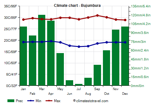
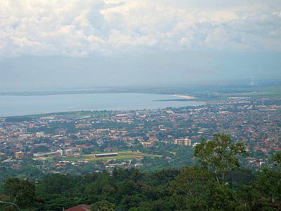
Bujumbura, is located along the shores of the lake. Here, it's hot throughout the year, but without excesses, in fact, the maximum temperature is around 29 °C (84 °F) all year round, except from mid-August to October, when it reaches 30/31 °C (86/88 °F).
In Bujumbura, 835 mm (33 in) of rain fall per year, with a peak in April and May, when rainfall reaches or exceeds 90 mm (3.5 in) per month, and a minimum from June to August, when the rains are rare and sporadic.

In the west, the altitude goes below a thousand meters (3,300 feet) also along the border with Congo, where the Rusizi River flows, and where it can sometimes be very hot between September and March, with peaks around 35 °C (95 °F).
Plateau
Apart from Bujumbura, most of Burundi's cities are located on the plateau, and therefore have a cooler climate.
Gitega
 Gitega
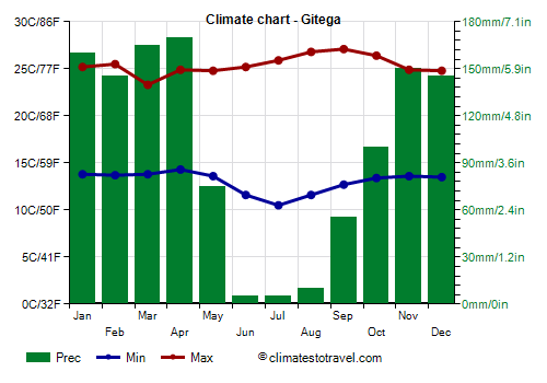
, the capital and second largest city of Burundi, is located in the center of the country, at an altitude of 1,700 metres (5,600 ft). Daytime temperatures reach 27 °C (81 °F) in August and September, at the end of the dry season.
In Gitega, the rains are a little more abundant than in Bujumbura, according to the rule that the rains increase with increasing altitude.
High altitude
In western Burundi, east of the Rusizi River and Lake Tanganyka, there is also a
mountainous area, where the altitude exceeds 2,000 meters (6,500 feet). The northern part is occupied by the Kibira National Park, while more to the south, we find Mount Heha, which is the highest peak of the country with its 2,684 meters (8,806 feet).
Rwegura

In
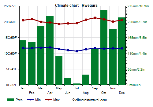
Rwegura, located in the north-west, at 2,300 meters (7,500 ft) above sea level, daytime temperatures fluctuate between 19 and 21 °C (66 and 70 °F) throughout the year.
In this mountainous area, rainfall reaches 1,700 mm (68 in) per year, and it's abundant from October to April, although there is a certain decrease in January and February.
When to go
The best time to visit Burundi runs from
June to August, since it is clearly the driest and sunniest time of the year. Anyway, in this season, it can sometimes be cool or even cold at night, with temperatures around 12 °C (54 °F) in Bujumbura and even below on the plateau.
What to pack
In winter (June to August): in Bujumbura, Lake Tanganyika and the lowlands of the west, bring light clothes, a sweatshirt and a light jacket, and a light scarf for the breeze. On the plateau and in the mountains, bring spring/autumn clothes (light for the day), a sweater and a warm jacket for the evening, a sun hat, and hiking shoes.
In the rest of the year: in Bujumbura, Lake Tanganyika and the lowlands of the west, bring light clothing, a light sweatshirt for the evening, and a light raincoat or umbrella. On the plateau and in the mountains, bring spring/autumn clothes, being ready to remove the outer layer during the day, a jacket, and a raincoat for the evening; a sun hat, hiking shoes.
Climate data - Burundi
| Bujumbura (800 meters) |
|---|
|
| Jan | Feb | Mar | Apr | May | Jun | Jul | Aug | Sep | Oct | Nov | Dec |
|---|
| Min temp. | 19 | 19 | 19 | 20 | 19 | 18 | 17 | 17 | 19 | 19 | 19 | 19 |
|---|
| Max temp. | 29 | 30 | 29 | 29 | 30 | 30 | 29 | 30 | 31 | 30 | 29 | 29 |
|---|
| Precip. | 100 | 85 | 120 | 110 | 55 | 10 | 5 | 15 | 35 | 60 | 95 | 100 |
|---|
| Prec. days | 16 | 19 | 18 | 18 | 10 | 2 | 1 | 2 | 8 | 15 | 19 | 19 |
|---|
|
|
| Sun hours | 5 | 6 | 6 | 6 | 7 | 8 | 9 | 8 | 7 | 6 | 5 | 5 |
|---|
|
| Gitega (1,700 meters) |
|---|
|
| Jan | Feb | Mar | Apr | May | Jun | Jul | Aug | Sep | Oct | Nov | Dec |
|---|
| Min temp. | 14 | 14 | 14 | 14 | 14 | 12 | 10 | 12 | 13 | 13 | 14 | 14 |
|---|
| Max temp. | 25 | 26 | 23 | 25 | 25 | 25 | 26 | 27 | 27 | 26 | 25 | 25 |
|---|
| Precip. | 160 | 145 | 165 | 170 | 75 | 5 | 5 | 10 | 55 | 100 | 150 | 145 |
|---|
| Prec. days | 23 | 19 | 21 | 22 | 14 | 2 | 1 | 2 | 8 | 17 | 23 | 24 |
|---|
|
|
|
|
| Musasa (1,285 meters) |
|---|
|
| Jan | Feb | Mar | Apr | May | Jun | Jul | Aug | Sep | Oct | Nov | Dec |
|---|
| Min temp. | 16 | 16 | 16 | 16 | 16 | 13 | 12 | 13 | 15 | 16 | 16 | 16 |
|---|
| Max temp. | 28 | 26 | 28 | 28 | 27 | 28 | 28 | 29 | 31 | 30 | 28 | 28 |
|---|
| Precip. | 170 | 140 | 110 | 195 | 80 | 5 | 0 | 10 | 30 | 85 | 190 | 155 |
|---|
| Prec. days | 18 | 16 | 18 | 19 | 11 | 1 | 1 | 1 | 5 | 12 | 18 | 20 |
|---|
|
|
|
|
| Muyinga (1,750 meters) |
|---|
|
| Jan | Feb | Mar | Apr | May | Jun | Jul | Aug | Sep | Oct | Nov | Dec |
|---|
| Min temp. | 15 | 15 | 15 | 15 | 15 | 14 | 14 | 14 | 15 | 15 | 14 | 14 |
|---|
| Max temp. | 25 | 25 | 25 | 24 | 24 | 26 | 26 | 27 | 27 | 26 | 25 | 25 |
|---|
| Precip. | 120 | 110 | 155 | 185 | 80 | 10 | 5 | 25 | 60 | 105 | 135 | 155 |
|---|
| Prec. days | 16 | 15 | 18 | 21 | 13 | 2 | 2 | 3 | 10 | 16 | 21 | 19 |
|---|
|
|
|
|
| Ngozi (1,840 meters) |
|---|
|
| Jan | Feb | Mar | Apr | May | Jun | Jul | Aug | Sep | Oct | Nov | Dec |
|---|
| Min temp. | 12 | 12 | 12 | 12 | 11 | 9 | 9 | 10 | 12 | 12 | 12 | 12 |
|---|
| Max temp. | 22 | 22 | 22 | 21 | 21 | 21 | 22 | 23 | 24 | 23 | 22 | 21 |
|---|
| Precip. | 165 | 175 | 205 | 205 | 115 | 10 | 5 | 15 | 65 | 125 | 185 | 175 |
|---|
| Prec. days | 22 | 19 | 21 | 23 | 16 | 3 | 1 | 3 | 9 | 17 | 23 | 24 |
|---|
|
|
|
|
| Nyanza-Lac (880 meters) |
|---|
|
| Jan | Feb | Mar | Apr | May | Jun | Jul | Aug | Sep | Oct | Nov | Dec |
|---|
| Min temp. | 19 | 19 | 19 | 19 | 19 | 18 | 16 | 17 | 18 | 19 | 19 | 19 |
|---|
| Max temp. | 28 | 28 | 28 | 29 | 29 | 29 | 30 | 30 | 31 | 29 | 28 | 28 |
|---|
| Precip. | 160 | 120 | 160 | 165 | 105 | 10 | 5 | 10 | 20 | 105 | 180 | 190 |
|---|
| Prec. days | 16 | 13 | 16 | 17 | 9 | 2 | 1 | 1 | 3 | 12 | 18 | 19 |
|---|
|
|
|
|
| Rwegura (2,300 meters) |
|---|
|
| Jan | Feb | Mar | Apr | May | Jun | Jul | Aug | Sep | Oct | Nov | Dec |
|---|
| Min temp. | 12 | 12 | 12 | 12 | 11 | 11 | 11 | 11 | 12 | 12 | 12 | 12 |
|---|
| Max temp. | 20 | 21 | 20 | 20 | 19 | 20 | 20 | 21 | 21 | 21 | 20 | 21 |
|---|
| Precip. | 155 | 150 | 205 | 240 | 100 | 25 | 5 | 35 | 125 | 260 | 195 | 235 |
|---|
| Prec. days | 20 | 18 | 22 | 24 | 17 | 4 | 2 | 4 | 13 | 20 | 23 | 22 |
|---|
|
|
|
|
See also the
temperatures month by month