Select units of measurement for the temperature and rainfall tables (metric or imperial).
Average weather, temperature, rainfall, sunshine
The climate of Mayotte is
tropical, with a hot, humid and rainy season from December to April, when the north-west monsoon prevails, and a relatively
cool, dry and sunny season from June to October, when the south-east trade winds prevail, while May and November can be considered as transitional months.
Mayotte is an archipelago consisting of two main islands,
Grande-Terre (or Maore) and
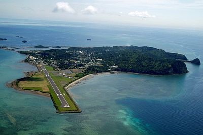
Petite-Terre (or Pamanzi), plus some smaller islets. The archipelago is an overseas department of France and is located in the Indian Ocean, at a latitude of nearly 13 degrees south.
The capital is
Mamoudzou and is located on the east coast of the main island.
The climate in detail
Temperature and rain
Pamanzi

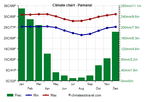
At the Dzaoudzi–Pamandzi International Airport, the average daily
temperature ranges between 28 °C (82 °F) in the warmest period (January-April) to 25/26 °C (77/79 °F) in the coolest period (June-September). From June to September, the temperature never exceeds 32 °C (90 °F), while from November to March, it can sometimes reach 34/35 °C (93/95 °F), morevoer, high humidity in this period makes the heat uncomfortable.
Total annual
rainfall is not very high, and amounts to 1,200 millimeters (47 inches) on the small island of Pamanzi, where more than 100 mm (4 in) fall from December to April; the rainiest month is January, when the rains are definitely abundant.
Even during the rainy period, however, the amount of
sunshine is acceptable because the tropical rains mainly occur in the form of downpours or thunderstorms, which can be intense but do not last long. However, in the two rainiest months, January and February, there are around 6 hours of sunshine per day. The sunniest period is the dry winter period, with 8/8.5 hours of sunshine per day.
During the dry period, some brief thunderstorms are still possible, especially on the main island, where there are some small elevations: the highest point is
Mount Benara, 600 meters (2,170 feet) high; in addition, the archipelago is protected by Madagascar, which is located just 300 kilometers (185 miles) away to the south-east.

Sea temperature
The
sea in Mayotte is always warm enough to swim in, in fact, the water temperature ranges from 26 °C (79 °F) in the July-September period to 29 °C (84 °F) in the February-April period.
Tropical cyclones
Mayotte is located in the path of
tropical cyclones, which can affect the islands from November to mid-May, with a greater chance from late December to mid-April.
When to go
The best time to visit Mayotte for a beach holiday is from
June to October: the temperature is pleasantly warm, the sun frequently shines and the rains are rare.
What to pack
In
winter (June to August): bring light clothes, a sweatshirt for the evening, and a scarf for the breeze. When going to the reef, you can bring snorkeling equipment, including water shoes or rubber-soled shoes.
In
summer (December to February): bring tropics-friendly, loose-fitting clothing, light shirts and pants of natural fibers (cotton, linen), a light sweatshirt for the evening, and a light raincoat or umbrella for the rain showers.
Climate data - Mayotte
| Pamanzi |
|---|
|
| Jan | Feb | Mar | Apr | May | Jun | Jul | Aug | Sep | Oct | Nov | Dec |
|---|
| Min temp. | 25 | 25 | 25 | 25 | 25 | 24 | 22 | 21 | 22 | 23 | 25 | 25 |
|---|
| Max temp. | 31 | 31 | 31 | 31 | 30 | 29 | 28 | 28 | 29 | 30 | 31 | 31 |
|---|
| Precip. | 270 | 230 | 205 | 100 | 30 | 20 | 10 | 10 | 20 | 60 | 85 | 185 |
|---|
| Prec. days | 15 | 13 | 14 | 7 | 4 | 2 | 2 | 2 | 3 | 5 | 6 | 11 |
|---|
| Humidity | 80% | 80% | 80% | 77% | 74% | 72% | 72% | 74% | 75% | 75% | 76% | 78% |
|---|
| Day length | 13 | 12 | 12 | 12 | 12 | 11 | 12 | 12 | 12 | 12 | 13 | 13 |
|---|
| Sun hours | 6 | 6 | 7 | 8 | 8 | 8 | 8 | 9 | 9 | 8 | 8 | 7 |
|---|
| Sea temp | 29 | 29 | 29 | 29 | 28 | 27 | 26 | 26 | 26 | 27 | 28 | 28 |
|---|