Select units of measurement for the temperature and rainfall tables (metric or imperial).
Average weather, temperature, rainfall, sunshine
In the Seychelles, the climate is
tropical, hot all year round. From November to March, there is a rainy and muggy season due to the northwest monsoon, while from June to September, when the southeast trade winds prevail, there is a dry and slightly cooler season. Tropical rains usually occur in the form of downpours or thunderstorms, and in the Seychelles, they usually occur in the afternoon in the sultry and rainy season, and at night in the driest season (when they are fairly frequent but of short duration).
The average daily
temperature is around 26 °C (79 °F) in July and August, 27 °C (81 °F) in January, and 28 °C (82 °F) in March, April, and May, which are the warmest months. However, the temperature varies little both between night and day and between seasons: it rarely exceeds 33 °C (91 °F) during the day or drops below 22 °C (72 °F) at night.
The Seychelles archipelago is made up of more than a hundred islands, islets and atolls, scattered in the Indian Ocean over a wide area, up to 1,200 kilometers (750 miles) wide; therefore, although they have a fairly homogeneous climate, they still have some differences.
The islands can be divided into
two groups. In the north, we find the
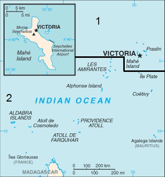
Inner Islands (area 1 on the map), which include the so-called Granitic Seychelles; among these, there are the largest and most densely populated islands (Mahé, Praslin and La Digue). In the south, we find the
Outer Islands (area 2 on the map), which are flat coral atolls stretched towards the south-west.

As regards to the
rains, the northern islands (which are closer to the Equator) are generally rainier than the southern ones. The northernmost islands, at a latitude of 3 degrees south, are Bird Island, where annual precipitation is around 1,950 millimeters (77 inches), and Denis Island, where it is around 1,700 mm (67 in). Mahé, the main island, at a latitude of 4 degrees south, is the rainiest. The southernmost of the Outer Islands are drier, in particular the
Farquhar Group, and even more so the
Aldabra Group in the south-west, so much so that rainfall drops to 985 mm (38.5 in) per year on the island of the same name and to as low as 865 mm (34 in) on the smaller island of Assumption.
The rain pattern in the Seychelles is quite
erratic from year to year, in particular, it can be affected by the so-called
ENSO cycle. In
El Niño years, it can sometimes rain a lot during the dry season, while the rainy season can be drier than normal. In La Niña years, the opposite happens.
The Seychelles are close to the Equator, in fact, their latitude ranges from 3 to 10 degrees south, which means that the day lasts about 12 hours all year round, and sunset comes quite early, between 6 and 6:30 p.m.
The climate in detail
The seasons
The
rainy season runs from October to April. During the month of October, the rains begin (which in some years may already be violent) and the south-east trade winds stop blowing.
By November, we are in the sultry and rainy season, and the wind is weak.
December and January are the months when the rains are more frequent and abundant. In the other months (ie in October and November, and from February to April) it generally rains less, even though it depends on the years.
From February to April, the rains decrease a little and the hours of sunshine increase, and with them the temperature. The sultriest months are March and April: the temperature reaches more easily 32/33 °C (90/91 °F), and the wind is still weak. April is the hottest month of the year.
In May, it is still hot but the south-east trade winds begin to blow, cooling the air. It is the sunniest month, although some heavy showers are still possible.
The coolest months, July and August, are the acme of the
south-east trade winds period, which goes from June to September (and partly also in May and October).
In this period, the
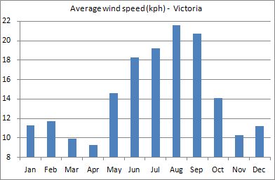
wind can make the sea choppy, especially along the coasts exposed to the east and south. The wind reaches its peak in August, with gusts of 50/60 kph (30/37 mph), it can bring seaweed to the shore and create dangerous currents near the most exposed coasts. On the other hand, this wind is appreciated by surfers. In the following image, we can see the average wind in Victoria.

Mahé

In
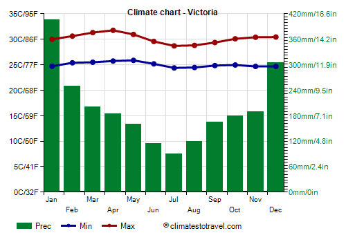
Victoria, the capital, located on the largest island, Mahé, the average temperature ranges from around 26.5 °C (79.7 °F) in July and August to 28.7 °C (83.7 °F) in April.
As mentioned, the island of Mahé is
the rainiest. In Victoria, 2,350 millimeters (93 inches) of rain fall per year; the wettest month is January, followed by December; the driest period runs from June to August.
In the interior of the island, there are some
hills where annual rainfall reaches 3,500 mm (138 in). The driest areas of the island are both the north and the south, where the rainfall drops below 2,000 mm (79 in) per year.
The amount of
sunshine is good in the relatively dry period, while in the rainiest months, from December to February, the sun shines on average for 5/6 hours a day. Here are the average sunshine hours per day.
In the Seychelles, the
sea temperature is always warm enough for swimming, since it ranges from 26.5 °C (79.5 °F) in July and August to 30 °C (86 °F) in April.

Tropical cyclones
The Seychelles can be affected by
tropical cyclones, which form to the south of the Equator in the period November to mid-May, and more frequently from late December to mid-April.
The islands most at risk are the southernmost of the Outer Islands, in particular, the groups of Aldabra and Farquhar. Cyclones bring strong winds and torrential rains.
The northernmost islands, including Mahé, being close to the Equator, are generally spared by cyclones, or they are affected marginally, but they can sometimes be more clearly affected, as happened in May 1990 with Tropical Storm Ikonjo, and in January 2013 with Cyclone Felleng, which caused considerable damage.
When to go
In the Seychelles, the least sultry period, and also the driest and sunniest, is from
June to August. In this period, however, the wind can be moderate and make the sea rough. In this period, the beaches exposed to the north-west (eg Beau Vallon Beach in Mahé) will therefore be preferable.
The period from
March to May is the hottest of the year, albeit slightly, and there is the risk of some heavy rainstorms but especially of cyclones, which, as mentioned, affect only marginally the main islands of the north.
The month of
October, the first of the rainy season, is also exposed to heavy showers, but at least, it is outside the cyclone season.
The worst months are December and January, since they are the most sultry and rainy, as well as the least sunny, even though the sun shines for a few hours a day.
What to pack
In
winter (June to August): bring light clothes, a light sweatshirt for the evening, a scarf for the breeze, a light raincoat, and a sweater for those who are sensitive to cold. When going to the reef, you can bring snorkeling equipment, including water shoes or rubber-soled shoes.
In
summer (December to February): bring tropics-friendly, loose-fitting clothing, a light sweatshirt for the evening, and a light raincoat or umbrella.
Climate data - Seychelles
| Victoria |
|---|
|
| Jan | Feb | Mar | Apr | May | Jun | Jul | Aug | Sep | Oct | Nov | Dec |
|---|
| Min temp. | 25 | 25 | 25 | 26 | 26 | 25 | 24 | 24 | 25 | 25 | 25 | 25 |
|---|
| Max temp. | 30 | 31 | 31 | 32 | 31 | 30 | 29 | 29 | 29 | 30 | 30 | 30 |
|---|
| Precip. | 405 | 250 | 200 | 185 | 160 | 115 | 90 | 120 | 165 | 180 | 190 | 305 |
|---|
| Prec. days | 20 | 13 | 15 | 16 | 16 | 17 | 17 | 16 | 17 | 16 | 16 | 21 |
|---|
| Humidity | 82% | 79% | 79% | 79% | 78% | 79% | 80% | 79% | 79% | 79% | 79% | 80% |
|---|
| Day length | 12 | 12 | 12 | 12 | 12 | 12 | 12 | 12 | 12 | 12 | 12 | 12 |
|---|
| Sun hours | 5 | 6 | 7 | 8 | 8 | 8 | 7 | 7 | 8 | 7 | 7 | 6 |
|---|
| Sea temp | 28 | 29 | 29 | 30 | 29 | 27 | 26 | 26 | 27 | 28 | 28 | 29 |
|---|