Select units of measurement for the temperature and rainfall tables (metric or imperial).
Average weather, temperature, rainfall, sunshine
Zambia, a country located in southern Africa, is almost entirely covered by a
plateau, which tempers the climate, making the temperature generally acceptable for most of the year.
In Zambia, the climate is
tropical or sub-tropical depending on altitude, with a hot, humid, and rainy season from mid-November to March and a
dry season from April to mid-November.
Within the dry season, there is a
cool period from mid-May to mid-August, and a progressively
hotter period from September to mid-November, when the heat becomes torrid, that is, intense but with low humidity. In fact, October is typically the hottest month of the year. On the other hand, moisture is high during the rainy season, which begins around the middle of November, and lasts until the end of March.
The
temperature in Zambia varies according to altitude and latitude. The plateau's
altitude ranges mostly from 900 to 1,500 meters (3,000 to 4,900 feet), but some areas descend to almost 500 meters (1,600 feet), in the far south along the Zambezi River (and in Lake Kariba, created by a dam on the river), and also in the east, in the Luangwa National Park, where the Luangwa River flows. On the contrary, in the north, the altitude reaches 1,800 meters (5,900 ft) near Mbala, while in the north-east, near the border with Malawi, where the cool grassland of the Nyika National Park is found, it even reaches 2,200 meters (7,200 ft).
The climate in detail
The seasons
During
the coolest period, from mid-May to mid-August, it can get cold at night, especially in the southern regions, where the temperature can drop to around freezing (0 °C or 32 °F). The driest months are June, July, and August, when it practically never rains. During the dry season, weather conditions are generally very good: the sky is clear and the air is clear.
Sometimes, however, owing to the ancestral custom of burning harvest residues in order to prepare the land for crop rotation, the air may smell of
smoke, and some
scattered fires can be seen. In contrast, in October and November, the first thunderstorms after the dry season can trigger natural fires, when trees are struck by lightning.
In the
rainy season (December to March in the North and December to February in the South), the rains occur mainly in the form of downpours or thunderstorms.
In Zambia,
floods caused by heavy rains are quite normal.
The
wettest areas are the northern ones, namely, the North-Western Province, the Copperbelt Province, and the Northern Province, where precipitation exceeds 1,000 millimeters (40 inches) per year, and in some areas, it can reach 1,400 mm (55 in).
The
most arid area is, in the south-west, the southern part of Barotseland, where the Zambezi River separates Zambia from Namibia and Zimbabwe: in this area, annual rainfall is around 600 mm (23.5 in) or even a little below.
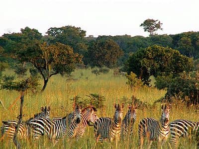
On the border with Zimbabwe, the Zambezi River feeds the magnificent
Victoria Falls, which are about 100 meters (330 feet) high, twice as wide and one and a half taller than the Niagara Falls.
The lowlands
In the areas of the north located below 1,000 meters (3,300 feet), and on the shores of Lake Kariba in the south, the winter climate is milder, especially at night.
Lake Tanganyika
In the
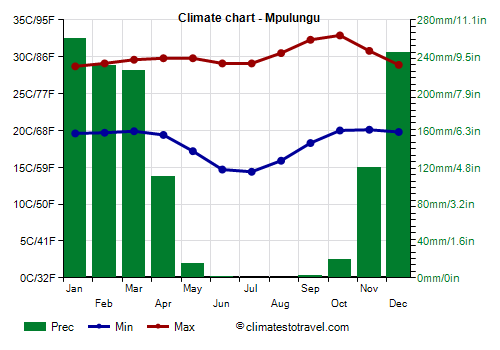
far north, a small portion of Lake Tanganyika belongs to Zambia, and its banks are at 770 meters (2,500 ft). Here (see Mpulungu), the temperature remains high even in winter, also because we are just 8 degrees south of the Equator.
On average, 1,200 mm (48 in) of rain fall per year, with heavy rains from December to March; the rainy season is slightly longer than in the rest of the country, in fact, more than 100 mm (4 in) fall even in April and November. From May to October, it almost never rains.
The smaller Lake Mweru, located at no great distance from Lake Tanganyika, sits at 920 meters (3,020 ft); further south but still in the Northern Province, Lake Bangweulu is at 1,150 meters (3,770 ft).
The plateau
On the plateau, the night temperature from May to August drops a lot, becoming very cool, and sometimes even cold.
Lusaka
The capital city,
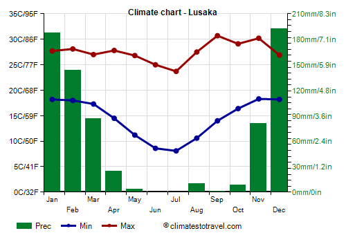
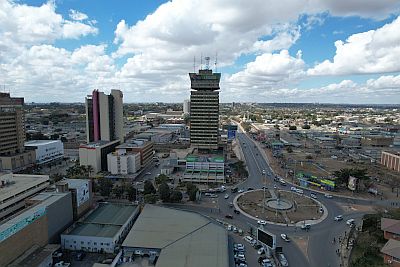
Lusaka, is located in the south-central, 1,250 meters (4,100 feet) above sea level.
In December, January, and February, at the height of the rainy season, temperatures hover around 28 °C (82 °F) during the day and around 18 °C (64 °F) at night.
On the other hand, in the coolest months, June and July, the temperature is around 24/25 °C (75/77 °F) in the daytime and 8/9 °C (46/48 °F) at night; sometimes, however, it can approach freezing. At the end of the dry season, from September to November, the highest temperatures of the year are recorded, with peaks of about 35/37 °C (95/99 °F).
Rainfall in Lusaka amounts to 750 mm (29.5 in) per year, with a maximum from December to February, when more than 100 mm (4 in) of rain fall per month, while from May to October, it almost never rains.
In Lusaka, and in general in Zambia, the sun shines regularly in the dry season, while in the rainy season, the sun alternates with the clouds.
North of Lusaka and north-east of the Kafue National Park, we find the Lukanga Swamp, a vast wetland area located at 1,100 meters (3,600 feet) above sea level.
Livingstone
 Livingstone
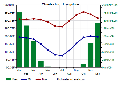
, a city named after the Scottish explorer who discovered the Victoria Falls, is located in the far south, 900 meters (3,000 ft) above sea level, just a few kilometers (or miles) from the falls. Here, the heat is intense from September to November, with peaks of 40 °C (104 °F).
On the other hand, the winter nights are cold because of the more southern location, even though the altitude is slightly lower than in the capital. The cold record is -2 °C (28 °F).
In Livingstone, rainfall amounts to 645 mm (25.5 in) per year: we are in one of the driest areas of the country.
Tropical cyclones
Zambia is located at a certain distance from the sea, so it is not directly affected by tropical cyclones; however, it can not be excluded that a cyclone coming from the Indian Ocean could penetrate inland, bringing heavy rains, as happened in January 1996 with Cyclone Bonita.
The cyclone season in the Southwest Indian Ocean runs from November to mid-May, but the period when they are most likely goes from late December to mid-April.
When to go
The best time to go to Zambia is from
May to August: it's the coolest period of the year, and it's dry and sunny. However, nights can be cold, especially above 1,000 meters (3,300 feet).
In September and October, the heat is intense, with peaks of 40 °C (104 °F), especially at an altitude of about 1,000 meters (3,300 feet) or less.
During the rainy season, not only the weather is hot and muggy, but also the rains can cause flooding and make travelling difficult.
What to pack
In
winter (June to August): pack light clothes for the day, but also a sweater, a jacket and a hat for the evening; a sun hat and sunscreen.
In
summer (December to February): pack light clothes for the day, and a sun hat; a sweatshirt and a spring jacket for the evening; a light raincoat or umbrella.
Climate data - Zambia
| Chipata (1,030 meters) |
|---|
|
| Jan | Feb | Mar | Apr | May | Jun | Jul | Aug | Sep | Oct | Nov | Dec |
|---|
| Min temp. | 19 | 18 | 18 | 17 | 15 | 13 | 12 | 15 | 18 | 20 | 20 | 19 |
|---|
| Max temp. | 28 | 28 | 29 | 29 | 28 | 26 | 26 | 28 | 31 | 33 | 32 | 29 |
|---|
| Precip. | 280 | 240 | 160 | 40 | 5 | 0 | 0 | 0 | 0 | 10 | 85 | 285 |
|---|
|
|
|
| Sun hours | 5 | 5 | 6 | 8 | 9 | 9 | 8 | 9 | 9 | 9 | 7 | 5 |
|---|
|
| Choma (1,320 meters) |
|---|
|
| Jan | Feb | Mar | Apr | May | Jun | Jul | Aug | Sep | Oct | Nov | Dec |
|---|
| Min temp. | 17 | 17 | 16 | 13 | 9 | 6 | 6 | 8 | 12 | 16 | 17 | 17 |
|---|
| Max temp. | 27 | 27 | 27 | 27 | 26 | 24 | 23 | 26 | 30 | 31 | 30 | 28 |
|---|
| Precip. | 205 | 155 | 105 | 25 | 5 | 0 | 0 | 0 | 0 | 20 | 85 | 165 |
|---|
|
|
|
|
|
| Isoka (1,370 meters) |
|---|
|
| Jan | Feb | Mar | Apr | May | Jun | Jul | Aug | Sep | Oct | Nov | Dec |
|---|
| Min temp. | 17 | 17 | 17 | 16 | 13 | 11 | 10 | 12 | 14 | 16 | 17 | 17 |
|---|
| Max temp. | 28 | 27 | 27 | 27 | 26 | 25 | 25 | 27 | 30 | 32 | 31 | 28 |
|---|
| Precip. | 225 | 230 | 175 | 75 | 10 | 0 | 0 | 0 | 0 | 10 | 80 | 205 |
|---|
|
|
|
|
|
| Kabwe (1,180 meters) |
|---|
|
| Jan | Feb | Mar | Apr | May | Jun | Jul | Aug | Sep | Oct | Nov | Dec |
|---|
| Min temp. | 18 | 18 | 17 | 15 | 12 | 10 | 9 | 12 | 15 | 18 | 18 | 18 |
|---|
| Max temp. | 27 | 28 | 28 | 27 | 26 | 24 | 24 | 26 | 30 | 32 | 31 | 28 |
|---|
| Precip. | 225 | 105 | 20 | 5 | 0 | 0 | 0 | 0 | 10 | 110 | 210 | 225 |
|---|
|
|
|
| Sun hours | 6 | 6 | 7 | 9 | 9 | 9 | 10 | 10 | 10 | 9 | 7 | 6 |
|---|
|
| Kasama (1,380 meters) |
|---|
|
| Jan | Feb | Mar | Apr | May | Jun | Jul | Aug | Sep | Oct | Nov | Dec |
|---|
| Min temp. | 16 | 16 | 16 | 15 | 12 | 10 | 10 | 12 | 14 | 16 | 17 | 17 |
|---|
| Max temp. | 27 | 27 | 28 | 27 | 27 | 26 | 25 | 28 | 30 | 31 | 30 | 28 |
|---|
| Precip. | 270 | 265 | 245 | 75 | 5 | 0 | 0 | 0 | 5 | 40 | 125 | 270 |
|---|
|
|
|
|
|
| Livingstone (900 meters) |
|---|
|
| Jan | Feb | Mar | Apr | May | Jun | Jul | Aug | Sep | Oct | Nov | Dec |
|---|
| Min temp. | 19 | 19 | 18 | 15 | 11 | 8 | 8 | 11 | 15 | 19 | 20 | 20 |
|---|
| Max temp. | 31 | 31 | 31 | 31 | 29 | 26 | 26 | 30 | 34 | 36 | 34 | 32 |
|---|
| Precip. | 175 | 135 | 85 | 20 | 0 | 0 | 0 | 0 | 0 | 10 | 80 | 140 |
|---|
| Prec. days | 16 | 14 | 9 | 3 | 0 | 0 | 0 | 0 | 0 | 4 | 11 | 16 |
|---|
|
|
| Sun hours | 7 | 7 | 8 | 9 | 10 | 10 | 10 | 10 | 10 | 9 | 8 | 7 |
|---|
|
| Lusaka (1,300 meters) |
|---|
|
| Jan | Feb | Mar | Apr | May | Jun | Jul | Aug | Sep | Oct | Nov | Dec |
|---|
| Min temp. | 18 | 18 | 17 | 14 | 11 | 9 | 8 | 11 | 14 | 16 | 18 | 18 |
|---|
| Max temp. | 28 | 28 | 27 | 28 | 27 | 25 | 24 | 28 | 31 | 29 | 30 | 27 |
|---|
| Precip. | 185 | 145 | 85 | 25 | 5 | 0 | 0 | 10 | 0 | 10 | 80 | 195 |
|---|
| Prec. days | 17 | 15 | 11 | 2 | 0 | 0 | 0 | 0 | 0 | 2 | 8 | 15 |
|---|
|
|
| Sun hours | 6 | 6 | 7 | 8 | 9 | 9 | 10 | 10 | 10 | 9 | 8 | 6 |
|---|
|
| Mansa (1,190 meters) |
|---|
|
| Jan | Feb | Mar | Apr | May | Jun | Jul | Aug | Sep | Oct | Nov | Dec |
|---|
| Min temp. | 17 | 17 | 17 | 15 | 12 | 9 | 9 | 10 | 14 | 16 | 17 | 17 |
|---|
| Max temp. | 27 | 28 | 28 | 28 | 27 | 26 | 26 | 28 | 31 | 32 | 30 | 28 |
|---|
| Precip. | 265 | 225 | 195 | 40 | 5 | 0 | 0 | 5 | 30 | 125 | 250 | 265 |
|---|
|
|
|
| Sun hours | 5 | 5 | 6 | 7 | 8 | 9 | 9 | 10 | 9 | 8 | 7 | 5 |
|---|
|
| Mfuwe (570 meters) |
|---|
|
| Jan | Feb | Mar | Apr | May | Jun | Jul | Aug | Sep | Oct | Nov | Dec |
|---|
| Min temp. | 21 | 20 | 20 | 18 | 14 | 11 | 11 | 13 | 16 | 19 | 21 | 21 |
|---|
| Max temp. | 32 | 32 | 32 | 32 | 31 | 30 | 30 | 32 | 36 | 37 | 37 | 33 |
|---|
| Precip. | 220 | 170 | 130 | 40 | 5 | 0 | 0 | 0 | 0 | 0 | 10 | 85 |
|---|
|
|
|
|
|
| Mongu (1,050 meters) |
|---|
|
| Jan | Feb | Mar | Apr | May | Jun | Jul | Aug | Sep | Oct | Nov | Dec |
|---|
| Min temp. | 19 | 19 | 19 | 17 | 14 | 10 | 10 | 13 | 17 | 19 | 19 | 19 |
|---|
| Max temp. | 30 | 29 | 30 | 31 | 29 | 28 | 27 | 30 | 34 | 34 | 32 | 30 |
|---|
| Precip. | 230 | 200 | 135 | 30 | 15 | 0 | 0 | 0 | 5 | 25 | 95 | 190 |
|---|
|
|
|
| Sun hours | 6 | 6 | 7 | 9 | 10 | 10 | 10 | 10 | 10 | 9 | 7 | 6 |
|---|
|
| Mpulungu (800 meters) |
|---|
|
| Jan | Feb | Mar | Apr | May | Jun | Jul | Aug | Sep | Oct | Nov | Dec |
|---|
| Min temp. | 20 | 20 | 20 | 19 | 17 | 15 | 14 | 16 | 18 | 20 | 20 | 20 |
|---|
| Max temp. | 29 | 29 | 30 | 30 | 30 | 29 | 29 | 30 | 32 | 33 | 31 | 29 |
|---|
| Precip. | 260 | 230 | 225 | 110 | 15 | 0 | 0 | 0 | 5 | 20 | 120 | 245 |
|---|
| Prec. days | 18 | 16 | 18 | 12 | 2 | 0 | 0 | 0 | 0 | 3 | 12 | 19 |
|---|
|
|
| Sun hours | 5 | 6 | 7 | 8 | 10 | 11 | 11 | 11 | 10 | 9 | 7 | 6 |
|---|
|
| Ndola (1,270 meters) |
|---|
|
| Jan | Feb | Mar | Apr | May | Jun | Jul | Aug | Sep | Oct | Nov | Dec |
|---|
| Min temp. | 18 | 17 | 17 | 15 | 11 | 9 | 8 | 11 | 14 | 17 | 18 | 18 |
|---|
| Max temp. | 27 | 28 | 28 | 28 | 28 | 26 | 26 | 28 | 31 | 32 | 31 | 28 |
|---|
| Precip. | 305 | 230 | 170 | 25 | 0 | 0 | 0 | 0 | 0 | 25 | 115 | 285 |
|---|
|
|
|
| Sun hours | 5 | 5 | 6 | 8 | 9 | 9 | 10 | 10 | 9 | 9 | 7 | 5 |
|---|
|
| Solwezi (1,390 meters) |
|---|
|
| Jan | Feb | Mar | Apr | May | Jun | Jul | Aug | Sep | Oct | Nov | Dec |
|---|
| Min temp. | 16 | 16 | 16 | 14 | 10 | 7 | 7 | 10 | 13 | 15 | 16 | 16 |
|---|
| Max temp. | 26 | 27 | 27 | 28 | 27 | 26 | 25 | 28 | 31 | 31 | 28 | 27 |
|---|
| Precip. | 275 | 225 | 210 | 50 | 5 | 0 | 0 | 0 | 5 | 45 | 160 | 290 |
|---|
|
|
|
|
|
See also the
temperatures month by month