Select units of measurement for the temperature and rainfall tables (metric or imperial).
Average weather, temperature, rainfall, sunshine hours

In the Ngorongoro Conservation Area, south-east of the Serengeti, the climate is
subtropical, since it is influenced by altitude. The
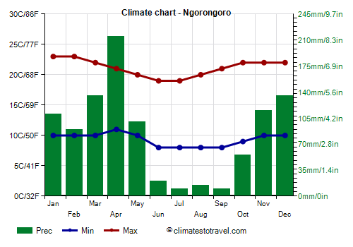
temperature is mild during the day and cool (or even a little cold) at night, and it's higher from September to April and lower from May to August, although the difference is not remarkable. The crater's rim is located at about 2,300 meters (7,500 ft) above sea level: in the Ngorongoro Crater Lodge, the average daily temperature is about 16 °C (61 °F) from October to April, while it drops to 13/14 °C (55/57 °F) from June to August; at night, it's a bit cold, and drops below 10 °C (50 °F) from May to October, but sometimes also in the rest of the year.
Here are the average temperatures of the Crater Lodge, located, as mentioned, at 2,300 meters (7,500 ft) above sea level.
Ngorongoro - Average temperatures|
| Month | Min | Max | Mean |
|---|
| January | 10 | 23 | 16.5 |
|---|
| February | 10 | 23 | 16.5 |
|---|
| March | 10 | 22 | 16 |
|---|
| April | 11 | 21 | 16 |
|---|
| May | 10 | 20 | 15 |
|---|
| June | 8 | 19 | 13.5 |
|---|
| July | 8 | 19 | 13.5 |
|---|
| August | 8 | 20 | 14 |
|---|
| September | 8 | 21 | 14.5 |
|---|
| October | 9 | 22 | 15.5 |
|---|
| November | 10 | 22 | 16 |
|---|
| December | 10 | 22 | 16 |
|---|
| Year | 9.3 | 21.2 | 15.2 |
|---|
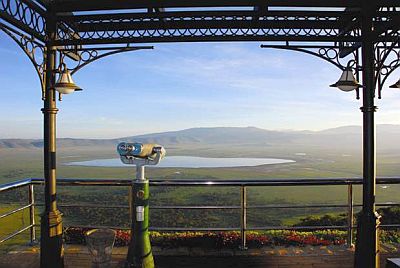
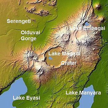
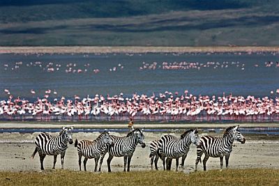
Inside the crater, the altitude is a bit lower, around 1,700 meters (5,600 ft), so the temperature is 3/4 degrees Celsius (5/7 °F) higher. Here, there is a lake, called Magadi or Makat (not to be confused with Lake Magadi in Kenya), inhabited by thousands of pink flamingos, while to the north-east, there is a smaller lake, Embagai. In contrast, both to the west and east of the crater, there are areas where the altitude even exceeds 3,000 meters (9,800 ft) above sea level: they are colder and wetter, often covered with clouds and occupied by forests.
Precipitation around the crater amounts to about 1,000 millimeters (40 inches) per year and is higher than in surrounding areas, which, as mentioned, are located at lower altitudes and are more arid as well as warmer. Anyway, in this area, there is a
dry season from June to September, which is also the coolest period, and a rainy season from October to May. Within the latter season, we can identify two rainy periods: the "short rains" from October to December, and the "long rains" from March to May, with April as the rainiest month of the year. However, the rains are abundant enough also in January and February, around 90/110 mm (3.5/4 in) per month. On the contrary, in the dry period, from June to September or October (until the short rains begin), there is little rain.
Here is the average precipitation, still at the Crater Lodge.
Ngorongoro - Average precipitation| Month | Days |
|---|
| January | 110 | 15 |
|---|
| February | 90 | 14 |
|---|
| March | 135 | 18 |
|---|
| April | 215 | 22 |
|---|
| May | 100 | 15 |
|---|
| June | 20 | 6 |
|---|
| July | 10 | 5 |
|---|
| August | 15 | 5 |
|---|
| September | 10 | 4 |
|---|
| October | 55 | 7 |
|---|
| November | 115 | 16 |
|---|
| December | 135 | 17 |
|---|
| Year | 1010 | 144 |
|---|
The amount of
sunshine in the Ngorongoro Conservation Area is good, but not great, since in addition to the rains, which occur in the form of showers and thunderstorms, a bit of cloudiness can form also in the dry season. However, the sun is very strong (we are just south of the Equator, and also at high elevations), so it requires appropriate protection. Here are the average sunshine hours per day.
Ngorongoro - Sunshine hours| Month | Average | Total |
|---|
| January | 8 | 250 |
|---|
| February | 8 | 225 |
|---|
| March | 7 | 215 |
|---|
| April | 6 | 180 |
|---|
| May | 7 | 215 |
|---|
| June | 7 | 210 |
|---|
| July | 7 | 215 |
|---|
| August | 7 | 215 |
|---|
| September | 8 | 240 |
|---|
| October | 8 | 250 |
|---|
| November | 7 | 210 |
|---|
| December | 7 | 215 |
|---|
| Year | 7.3 | 2645 |
|---|

The
Ngorongoro Crater, a UNESCO World Heritage Site, is a large volcanic caldera with a diameter of about 16 kilometers (10 miles), and it's famous because it hosts a rich
fauna of the savannah environment: hippos, black rhinos, giraffes, elephants, crocodiles, antelopes, gazelles, wild dogs, hyenas, leopards, lions etc.
Wildebeests and zebras, in the context of the "Great Migration" of the plains of
Serengeti and
Masai Mara, arrive in the area in January and February, and spread between the northern slope of the crater and the Olduvai Gorge, where they come to breed.

The Olduvai Gorge, the "cradle of mankind", is located at about 1,400 meters (4,600 feet) above sea level, north-west of the Ngorongoro area; beyond the gorge, there is the Serengeti. About 40 kilometers (25 miles) to the south-east, we find Lake Manyara, 950 meters (3,100 ft) above sea level; to the south-west, there is lake Eyasi, about 1,000 meters (3,300 feet) above sea level. Further to the north-east, about 90 km (55 mi), near the border with Kenya, we find Lake Natron, 600 meters (2,000 feet) above sea level, in a branch of the Rift Valley. The lower you go in altitude, the warmer the weather is, and from October to March, it can be hot during the day.

Best Time
The
best time to visit the Ngorongoro Conservation Area is the dry season,
from June to September. You must be equipped for the cold at night, and be ready to remove the outer layer during the day. In September, the temperature begins to increase a bit, and at lower altitudes, it can get hot during the day. In October, the temperature rises further, and while at the beginning it is still dry, in the course of the month, the short rains begin.
To spot the herds of wildebeest and zebras that make the "great migration", you can choose
January and February, when the animals arrive in this area. In this period, the temperature is high enough, and the days are hot at lower altitudes; afternoon showers are relatively frequent, but less so than in the two real rainy seasons (long and short rains).