Select units of measurement for the temperature and rainfall tables (metric or imperial).
Average weather, temperature, rainfall, sunshine
The climate of the Comoro Islands, an archipelago in the Indian Ocean south of the Equator, is
tropical, with a hot and rainy season from December to April, when the north-west monsoon prevails, and a relatively cool and dry season from May to November, when the south-east trade winds blow.
Of the three main islands that make up the archipelago, the two smaller ones (Mohéli and Anjouan) are occupied by hills in the interior, while the largest one, Grande Comore or Ngazidja, is home to a real mountain,
Karthala volcano, 2,360 meters (7,743 feet) high. The slopes enhance cloud formation, which can lead to showers and thunderstorms, especially on the main island, which, in fact, is the rainiest.
On Mount Karthala, up to 5,000 millimeters (195 inches) of
rain fall per year, while Moroni, located on the main island, receives 2,700 mm (106 in) of rain per year. In Fomboni, on the island of Mohéli, total annual rainfall is 2,100 mm (83 in), while Ouani, on the island of Anjouan (also known as Nzwani), receives 1,800 mm (70 in) of rain per year.
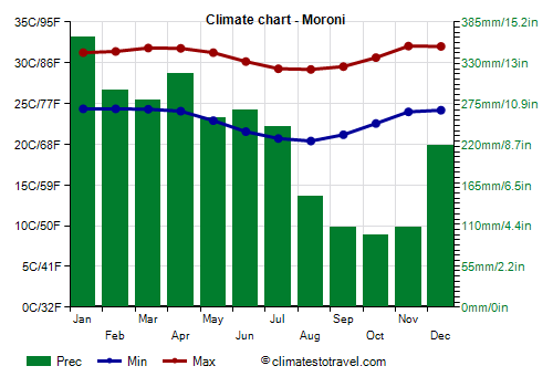
January is the rainiest month throughout the archipelago, with more than 300 mm (12 in) of rain along the coasts, while
the driest period goes from September to November. However, these rains, though intense, are short-lived, and they usually soon make room for the sun. On the smaller islands, during the dry season, showers are less frequent and less intense.
Despite the rains, the Comoros suffer from a shortage of fresh water due to the absence of rivers.
The climate in detail
Temperature and rain
Moroni

In the capital,
Moroni, located on the west coast of the island of Grande Comore, the warmest period is from January to April, with an average daily temperature around 28 °C (82 °F), while the coolest months are July, August and September, when the average drops to around 25 °C (77 °F).
As mentioned, Moroni is located on the rainiest island, due to the presence of Mount Karthala. The driest month in Moroni is October, with 95 mm (3.7 in) of rain, which shows that showers and thunderstorms can occur quite frequently even in the dry season, at least on the main island.
The amount of
sunshine in the Comoros is not exceptional, nor scarce. The sun shines for a few hours a day even in the wettest months. The sunniest period is that of the trade winds, ie May-November, when, however, a bit of cloudiness can form, especially near the mountains.

Sea temperature
The
sea in the Comoros is warm enough for swimming all year round: the water temperature ranges from 25 °C (77 °F) in August to 29 °C (84 °F) in the period from February to April.
Tropical cyclones
The Comoros are located in the path of
tropical cyclones, which can affect the islands from November to mid-May, though they are more likely from late December to mid-April.
When to go
The best time to visit the Comoros and enjoy their yet uncrowded beaches, runs from
June to October: it is the least sultry, the driest and sunniest period of the year, although some showers must still be put into account, especially on the main island. Here, given that the rains are still abundant in June and July, you can choose the period from August to October.
What to pack
In winter (June to August): bring light clothes, a sweatshirt for the evening, and a light scarf for the breeze.
When going to the reef, you can bring snorkeling equipment, including water shoes or rubber-soled shoes. To climb Mount Karthala, bring hiking boots, a fleece, a raincoat.
It's better for women to avoid shorts and miniskirts outside of tourist resorts.
In summer (December to February): bring tropics-friendly, loose-fitting clothing, light shirts and pants of natural fibers (cotton, linen) or synthetics that breathe, a light sweatshirt for the evening, and a light raincoat or umbrella.
Climate data - Comoros
| Moroni |
|---|
|
| Jan | Feb | Mar | Apr | May | Jun | Jul | Aug | Sep | Oct | Nov | Dec |
|---|
| Min temp. | 24 | 24 | 24 | 24 | 23 | 22 | 21 | 20 | 21 | 23 | 24 | 24 |
|---|
| Max temp. | 31 | 31 | 32 | 32 | 31 | 30 | 29 | 29 | 30 | 31 | 32 | 32 |
|---|
| Precip. | 365 | 295 | 280 | 315 | 255 | 265 | 245 | 150 | 110 | 95 | 110 | 220 |
|---|
| Prec. days | 18 | 16 | 18 | 18 | 12 | 12 | 12 | 10 | 11 | 12 | 12 | 16 |
|---|
| Humidity | 81% | 81% | 81% | 79% | 75% | 74% | 73% | 74% | 77% | 76% | 75% | 77% |
|---|
| Day length | 13 | 12 | 12 | 12 | 12 | 11 | 12 | 12 | 12 | 12 | 13 | 13 |
|---|
| Sun hours | 6 | 6 | 7 | 6 | 7 | 8 | 8 | 7 | 7 | 8 | 8 | 7 |
|---|
| Sea temp | 29 | 29 | 29 | 29 | 28 | 27 | 26 | 25 | 26 | 26 | 27 | 28 |
|---|