Select units of measurement for the temperature and rainfall tables (metric or imperial).
Average weather, temperature, rainfall, sunshine
Kenya is an African country, bisected by the Equator, yet it has
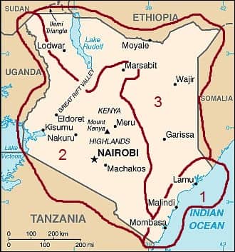
three types of climate: hot and humid along the coast (zone 1 on the map), temperate in the west and south-west, where there are mountains and plateaus (zone 2 on the map), and finally, hot and dry in the north and east (zone 3 on the map).
In general, the warmest period in Kenya is from February to March, while the coolest is from July to August, although the seasonal variations in temperature are small.
Both temperature and rainfall vary according to the prevailing winds, which produce
two seasons: from October to March, the hot and originally dry winds coming from Arabia (called
kaskazi) prevail, while from April to September, the prevailing winds (called
Kuzi) are cooler and wetter and blow from the Indian Ocean.
At the beginning of the two periods, and in correspondence with the two zenith passages of the sun, there are the two rainy seasons: the "
long rains" from March to May, and the less intense "
short rains" from October to December, while in the western highlands, it rains a lot even between June and September.
Rainfall is more abundant along the coast and in the south-west (zones 1 and 2), where it typically ranges from 800 to 2,000 millimeters (31 to 79 inches) per year, while in the arid zone (3 on the map), it drops below 500 mm (20 in). The rains mainly occur in the form of downpours or thunderstorms in the afternoon or evening.
However, the rains are quite
irregular. On the one hand, with global warming, they are declining in some areas is; on the other hand, during
El Niño years (as in 1997-98), or when the so-called Indian Ocean Dipole (IOD), also known as "Indian Niño" is positive (as in autumn 2019), the probability of heavy rainfall increases, which can lead to widespread flooding.
The climate in detail
1- The coast
On the coast, the climate is
warm all year round, with a hotter period from November to April and a relatively cool period from June to September.
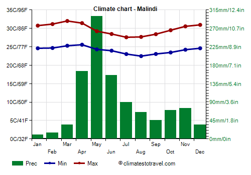
Temperatures are slightly higher from November to April, and a little lower from June to September.
In January and February, there is little rain, while in March and December, some showers may occur in the southern part of the coast (see
Malindi,
Mombasa).
The
long rains season here occurs later than in the rest of Kenya, and runs from
April to June, with May as the wettest month.
The sun shines all year round, though a little less from April to July.
The best months are August and September, in fact, they are the coolest ones, in addition, they are sunny and quite dry, with rains occurring in the form of short showers, which are soon replaced by the sun.
The
short rains season is not pronounced in the northern part of the coast (see
Lamu), and it's a bit more evident in Malindi and Mombasa, with some showers in October and November, usually not intense. However, it must be said that it depends on the year: sometimes, it can rain heavily even between October and December, and especially in November. However, rainfall on the coast amounts to 1,000/1,100 millimeters (40/43 inches) per year on average.
The
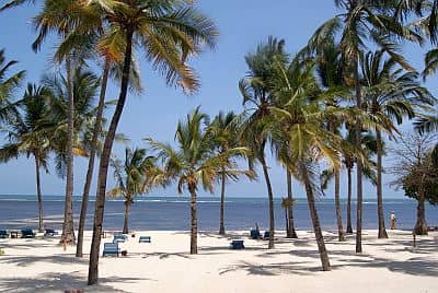
sea on the coast of Kenya is warm enough for swimming all year round: the water temperature ranges from 25.5 °C (78 °F) in August to 29 °C (84 °F) in April.
2- The plateau
On the plateau, the climate is generally
mild or pleasantly warm. Temperature and rainfall vary according to altitude and slope exposure, in general, however, the mountains make it easier for thunderclouds to form, so
the higher the altitude, the higher the chance of rain, and even in the dry seasons, some thunderstorms may break out.
At the highest elevations, above 3,000 meters (9,800 ft), night temperatures can drop below freezing (0 °C or 32 °F), and occasionally, this can also happen above 2,500 meters (8,200 ft).
The capital,
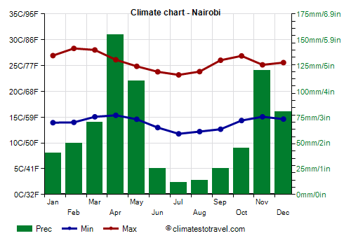
Nairobi, is located near the Equator, at 1,600 meters (5,250 feet) above sea level. The altitude makes daytime temperatures pleasant, while keeping nights cool. Highs hover around 23/24 °C (74/75 °F) in the coolest months (June, July and August) and around 27/28 °C (80/82 °F) in the warmest months (January, February and March), while lows drop to around 12/13 °C (54/55 °F) from June to September and go up to 14/15 °C (57/59 °F) from January to April.
In July and August, the sky is often cloudy, even though there is little rain, and sometimes at night it can be even cold, in fact, the temperature can drop to around 5 °C (41 °F).
Average annual
rainfall in Nairobi amounts to 745 mm (29 in). During the two rainy seasons, from March to May and from October to December, it rains quite often, though the rains occur in the form of showers here as well, so they do no reduce too much the sunshine hours. The driest months are January and February, although there can be a few showers even in this period.
In Nairobi, the sunniest period runs from December to March, while from June to September, although it is the dry season, the sky is often cloudy.
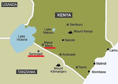
The
Masai Mara National Reserve, which borders the Serengeti in Tanzania, is located at an average altitude of around 1,500 meters (5,000 feet). Here, more than 100 mm (4 in) of rain fall per month from March to May and from October to December, and April is the rainiest month with 200 mm (8 in). However, there is no completely dry season, although July is the driest month with about 60 mm (2.4 in).
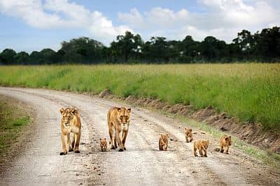
The parks of the south-east of the country are generally warmer and more arid than the heart of the plateau.
The
Amboseli National Park is located in the south, at 1,100 meters (3,600 feet) above sea level, and a short distance from the border with Tanzania, beyond which lies the Kilimanjaro, looming huge on the horizon. Here, there's a dry savannah environment, where elephants roam freely among many other animas such as lions, cheetahs, impalas, hyenas, giraffes, zebras, and where you can find Masai villages as well.
Precipitation amounts to 700 mm (27.5 in) per year, with the usual trend: a dry season from June to September, a less pronounced one in January and February, and the two rainy seasons, the most intense one from March to May (and with a maximum in April) and the less intense one from October to December.
A similar situation is found in the huge
Tsavo National Park, which lies to the east, and it's divided into two. The altitude ranges from 500 to 1,700 meters (1,600 to 5,600 feet) in the western park, and from 200 to 800 meters (600 to 2,600 feet) in the eastern park.
In
Voi, located in this area, at 580 meters (1,900 ft) above sea level (therefore in the lowest and warmest part of the park), daytime temperatures reach 33/34 °C (91/93 °F) in February and March, while they drop to 28/29 °C (82/84 °F) from June to August.
In this area and at these middle or low altitudes, rainfall is not abundant, since it amounts to 550 mm (21.5 in) per year.
In Voi too, the dry season is the least sunny, although the sun is slightly more frequent than in Nairobi.
The
Chyulu Hills National Park is located at a higher elevation, from 900 to 2,100 meters (2,900 to 6,900 ft): above 1,800 meters (5,900 ft), there is a montane forest, but also a series of volcanic peaks and lava tunnels that make the landscape lunar.
In the
highlands located north-west of Nairobi, above 2,000 meters (6,500 feet), the rain pattern is different than that of the rest of the country: in July and August, which are typically not too rainy in the rest of Kenya, the rains are plentiful, so much so that they range from 100 to 200 mm (4 to 8 in) per month, mostly in the form of thunderstorm in the afternoon or evening.
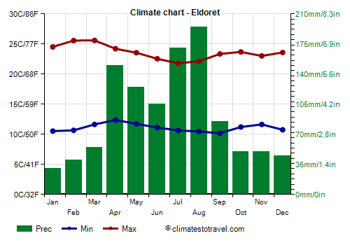
In this area (see Eldoret, Nakuru, or parks like
Kakamega, South Nandi, Mount Elgon, Mau Forest), there's
a peak in rainfall from April to September, while the relatively dry season is from October to March.
In
Eldoret, located about 260 km (165 mi) north-west of Nairobi and 2,100 meters (6,900 ft) above sea level, 1,100 mm (43 in) of rain falls per year, and the wettest months are July and August.
Due to the altitude, temperatures are lower than in Nairobi.
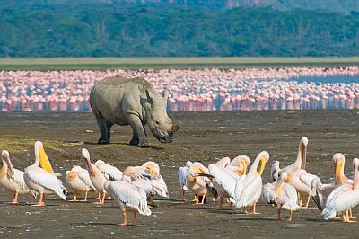
Lake Nakuru, where you can see pink flamingos, is located at 1,750 meters (5,750 feet). In the city of
Nakuru, located on the shores of the lake, 965 mm (38 in) of rain fall per year; here too, the period from June to August is not dry.
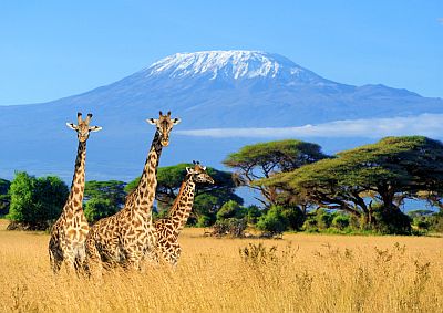
The highest peak in the country is
Mount Kenya, 5,199 meters (17,057 ft) high, which has different climatic zones according to altitude and slope exposure (the south-eastern slope is the most humid): above 2,000 meters (6,500 feet), the montane forest is found, around 2,500 meters (8,200 ft), the bamboo on the north side which is more arid, above 3,000 meters (9,800 ft), the heath, and above 4,000 meters (13,000 ft), the high altitude desert.
Above 4,700 meters (15,400 ft), there are also some glaciers, the largest of which is the Lewis Glacier, unfortunately in retreat because of global warming. At the highest altitudes it can snow, especially in Kenya's two rainy seasons, March-May and October-December.
West of Mount Kenya, the Aberdare Mountains reach 4,000 meters (13,000 ft). Mount Elgon is very high as well, since it reaches 4,321 meters (14,176 ft), however, the summit is located in Uganda.
The north-eastern portion of
Lake Victoria, which is located at 1,100 meters (3,600 feet) above sea level, belongs to Kenya. In
Kisumu, temperatures are stable throughout the year, and vary by a few degrees, highs ranging from 31.5 °C (89 °F) in February to 28 °C (82.5 °F) in June.
3- Arid zone
The
north is the driest and hottest area of Kenya, especially the areas located at lower altitudes.
Lake Turkana (or Rudolph) is located at 365 meters (1,200 feet) above sea level; here, the landscape is semi-desert in the southern part and desert in the north, where precipitation drops below 100 mm (4 in) per year.
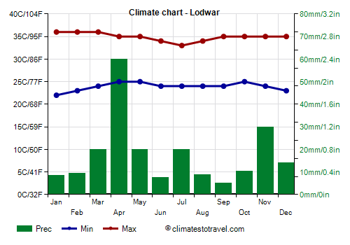
In this area, the weather is really hot all year round: in
Lodwar, the daily average is around 30 °C (86 °F) in almost all months, except in July and August, when it drops to 28/29 °C (82/84 °F).
The rains are sporadic and irregular; however, showers are more likely to happen in the two canonical rainy seasons of Kenya, ie from March to May and from October to December. The sun shines all year round.
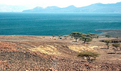
In the north-east too, near the border with Ethiopia and Somalia (see
Mandera,
Wajir), the climate is torrid (that is, very hot and dry), and here too, poor and irregular rains occur during the two periods, from March to May and from October to December.
In this torrid area, July and August are the best months because they are less hot, although not by much.
Tropical cyclones
Being at the Equator, Kenya is not in the trajectory of tropical cyclones, however, the coast, which lies just south of the equator, especially in the southernmost part (see Malindi, Mombasa), could theoretically be affected, even though this has never happened in the last few decades, probably because the prevailing currents keep them at a distance.
However, the coast can sometimes suffer the effects of
a cyclone that passes at some distance, over the Indian Ocean, bringing heavy rains, as happened in April 2016 with Cyclone Fantala, which brought torrential rainfall in Mombasa without reaching the coast.
Cyclones are formed on the Southern Indian Ocean in the period from November to mid-May, but they are more frequently from late December to mid-April.
When to go
On the
coast of Kenya, the best months for a beach holiday are August and September, since they are the coolest, and are also quite sunny and with rare rains. If you want, you can also choose January and February, which are the driest months of the year, but they are also hot and muggy; on the other hand, they are those in which the sea is calmer and clearer, so they are the most suitable for diving.
If you want to visit the
arid regions, July and August are the least hot months, although there is no big difference in comparison with the rest of the year: the heat is still intense.
For a
safari in national parks and in the highlands, you can choose from two periods: June to September and January-February. In the former period, the risk of showers in the afternoon and evening is higher at high altitudes, in the latter, the chance of intense heat at lower altitudes. However, since in the early hours of the day and at higher altitudes it can be cool throughout the year, it's better to dress in layers.
It is worth while to recall that the equatorial
sun is very strong, and it is even stronger at high altitudes; the sun is strongest in the two months when it passes directly overhead at noon, that is, in March and September.
The days last about 12 hours throughout the year, so the sun rises at about 6:00 in the morning and sets at 6:00 p.m., and it's used by the local population as a clock.
The
worst period is that of the long rains, from March to May in the interior, and from April to June on the coast, with a peak in April in the interior and May on the coast: it is typically the rainiest and the one with the greatest risk of flooding.
What to pack
For the
plateau, in general, dress in layers with spring/autumn clothes, warmer at higher altitudes, a sun hat and sunscreen; you can also bring a raincoat for showers in rainy periods, which should be lighter in the warm season and at low altitudes. For
parks and reserves, neutral-colored clothes, comfortable canvas shoes. When going
mountain climbing, bring hiking shoes; for the summit of Mount Kenya, throughout the year, cold weather clothing, a down jacket, a Gore-Tex jacket, a hat, gloves, a scarf, sunglasses, and sunscreen.
When going to the reef, you can bring snorkeling equipment, including water shoes or rubber-soled shoes.
In
winter (June to August): for the coast (Malindi, Mombasa) and the Tsavo National Park, bring light clothing, a sweatshirt for the evening, a scarf for the breeze, a light raincoat. For Lake Victoria, Nairobi, the Masai Mara and the plateau at intermediate altitudes, bring light clothes for the day, a sweater and a jacket for the evening, a raincoat or umbrella. For the highlands above 2,000 meters (6,500 feet), spring/autumn clothes; above 3,000 meters (9,800 ft), add a warm jacket and a hat. For the north and Lake Turkana, loose-fitting, light-colored clothing, light, long shirt and pants of natural fibers (cotton, linen), a wide-brimmed hat, sunglasses, a desert turban, and a sun hat.
In
summer (December to February): for the coast (Malindi, Mombasa) and the Tsavo National Park, bring light clothing of natural fibers, a light sweatshirt for the evening. For Lake Victoria, light clothing of natural fibers, a sun hat, a light sweatshirt for the evening, and a light raincoat or umbrella. For Nairobi, the Masai Mara and the plateau at intermediate altitudes, light clothes for the day, a jacket and a sweater for the evening. For the highlands above 2,000 meters (6,500 feet), spring/autumn clothes, a raincoat or umbrella; above 3,000 meters (9,800 ft), add a warm jacket and a hat. For the north and Lake Turkana, loose-fitting, light-colored clothing, light, long shirt and pants of natural fibers (cotton, linen), a wide-brimmed hat, sunglasses, a desert turban, and a sun hat.
Climate data - Kenya
| Amboseli (1,100 meters) |
|---|
|
| Jan | Feb | Mar | Apr | May | Jun | Jul | Aug | Sep | Oct | Nov | Dec |
|---|
| Min temp. | 15 | 16 | 17 | 17 | 16 | 15 | 14 | 14 | 14 | 15 | 16 | 16 |
|---|
| Max temp. | 30 | 30 | 30 | 27 | 26 | 25 | 24 | 25 | 27 | 28 | 28 | 28 |
|---|
| Precip. | 45 | 60 | 90 | 155 | 70 | 15 | 5 | 10 | 10 | 35 | 115 | 85 |
|---|
| Prec. days | 2 | 2 | 3 | 11 | 17 | 12 | 12 | 9 | 7 | 6 | 6 | 3 |
|---|
|
|
|
|
| Eldoret (2,100 meters) |
|---|
|
| Jan | Feb | Mar | Apr | May | Jun | Jul | Aug | Sep | Oct | Nov | Dec |
|---|
| Min temp. | 11 | 11 | 12 | 12 | 12 | 11 | 11 | 10 | 10 | 11 | 12 | 11 |
|---|
| Max temp. | 25 | 26 | 26 | 24 | 24 | 23 | 22 | 22 | 23 | 24 | 23 | 24 |
|---|
| Precip. | 30 | 40 | 55 | 150 | 125 | 105 | 170 | 195 | 85 | 50 | 50 | 45 |
|---|
| Prec. days | 5 | 5 | 8 | 15 | 15 | 13 | 19 | 21 | 11 | 9 | 9 | 7 |
|---|
| Humidity | 57% | 52% | 57% | 68% | 72% | 75% | 78% | 78% | 70% | 69% | 70% | 63% |
|---|
| Day length | 12 | 12 | 12 | 12 | 12 | 12 | 12 | 12 | 12 | 12 | 12 | 12 |
|---|
| Sun hours | 9 | 9 | 9 | 8 | 8 | 8 | 6 | 6 | 8 | 8 | 7 | 9 |
|---|
|
| Kisumu (1,100 meters) |
|---|
|
| Jan | Feb | Mar | Apr | May | Jun | Jul | Aug | Sep | Oct | Nov | Dec |
|---|
| Min temp. | 17 | 18 | 18 | 18 | 18 | 17 | 17 | 17 | 17 | 18 | 18 | 18 |
|---|
| Max temp. | 30 | 32 | 31 | 29 | 29 | 28 | 28 | 29 | 30 | 30 | 29 | 30 |
|---|
| Precip. | 90 | 100 | 170 | 180 | 170 | 90 | 70 | 70 | 90 | 100 | 130 | 90 |
|---|
| Prec. days | 6 | 7 | 9 | 12 | 12 | 8 | 8 | 9 | 9 | 9 | 10 | 7 |
|---|
| Humidity | 63% | 60% | 66% | 74% | 75% | 72% | 69% | 68% | 67% | 67% | 70% | 66% |
|---|
| Day length | 12 | 12 | 12 | 12 | 12 | 12 | 12 | 12 | 12 | 12 | 12 | 12 |
|---|
| Sun hours | 9 | 9 | 8 | 8 | 8 | 8 | 7 | 7 | 8 | 8 | 7 | 8 |
|---|
|
| Lodwar (500 meters) |
|---|
|
| Jan | Feb | Mar | Apr | May | Jun | Jul | Aug | Sep | Oct | Nov | Dec |
|---|
| Min temp. | 22 | 23 | 24 | 25 | 25 | 25 | 24 | 24 | 25 | 25 | 24 | 22 |
|---|
| Max temp. | 36 | 37 | 37 | 36 | 35 | 34 | 34 | 34 | 35 | 36 | 35 | 35 |
|---|
| Precip. | 10 | 10 | 20 | 60 | 20 | 10 | 20 | 10 | 5 | 10 | 30 | 15 |
|---|
| Prec. days | 1 | 1 | 2 | 4 | 2 | 1 | 2 | 1 | 1 | 1 | 2 | 1 |
|---|
| Humidity | 40% | 37% | 44% | 51% | 49% | 48% | 48% | 46% | 42% | 44% | 49% | 45% |
|---|
| Day length | 12 | 12 | 12 | 12 | 12 | 12 | 12 | 12 | 12 | 12 | 12 | 12 |
|---|
| Sun hours | 10 | 10 | 9 | 9 | 10 | 10 | 10 | 10 | 10 | 10 | 10 | 10 |
|---|
|
| Malindi |
|---|
|
| Jan | Feb | Mar | Apr | May | Jun | Jul | Aug | Sep | Oct | Nov | Dec |
|---|
| Min temp. | 25 | 25 | 25 | 26 | 24 | 24 | 23 | 22 | 23 | 23 | 24 | 25 |
|---|
| Max temp. | 31 | 31 | 32 | 31 | 29 | 28 | 28 | 28 | 28 | 30 | 31 | 31 |
|---|
| Precip. | 10 | 15 | 35 | 165 | 300 | 155 | 90 | 65 | 45 | 70 | 75 | 35 |
|---|
| Prec. days | 2 | 2 | 3 | 11 | 17 | 12 | 12 | 9 | 7 | 6 | 6 | 3 |
|---|
| Humidity | 76% | 74% | 75% | 77% | 81% | 77% | 77% | 77% | 77% | 78% | 79% | 78% |
|---|
| Day length | 12 | 12 | 12 | 12 | 12 | 12 | 12 | 12 | 12 | 12 | 12 | 12 |
|---|
| Sun hours | 9 | 9 | 9 | 8 | 7 | 8 | 8 | 9 | 9 | 9 | 9 | 9 |
|---|
| Sea temp | 28 | 28 | 29 | 29 | 28 | 27 | 26 | 26 | 26 | 27 | 28 | 28 |
|---|
| Masai Mara (1,600 meters) |
|---|
|
| Jan | Feb | Mar | Apr | May | Jun | Jul | Aug | Sep | Oct | Nov | Dec |
|---|
| Min temp. | 12 | 12 | 12 | 13 | 13 | 12 | 11 | 11 | 12 | 12 | 12 | 12 |
|---|
| Max temp. | 28 | 28 | 27 | 26 | 25 | 25 | 25 | 25 | 27 | 28 | 27 | 27 |
|---|
| Precip. | 95 | 100 | 145 | 210 | 155 | 95 | 60 | 80 | 95 | 100 | 155 | 115 |
|---|
|
|
|
| Sun hours | 9 | 9 | 8 | 7 | 7 | 8 | 7 | 7 | 8 | 8 | 8 | 8 |
|---|
|
| Nairobi (1,650 meters) |
|---|
|
| Jan | Feb | Mar | Apr | May | Jun | Jul | Aug | Sep | Oct | Nov | Dec |
|---|
| Min temp. | 14 | 14 | 15 | 15 | 15 | 13 | 12 | 12 | 13 | 14 | 15 | 15 |
|---|
| Max temp. | 27 | 28 | 28 | 26 | 25 | 24 | 23 | 24 | 26 | 27 | 25 | 26 |
|---|
| Precip. | 40 | 50 | 70 | 155 | 110 | 25 | 10 | 15 | 25 | 45 | 120 | 80 |
|---|
| Prec. days | 5 | 4 | 6 | 13 | 11 | 6 | 5 | 5 | 5 | 7 | 14 | 9 |
|---|
| Humidity | 64% | 58% | 63% | 74% | 76% | 73% | 70% | 68% | 63% | 63% | 75% | 72% |
|---|
| Day length | 12 | 12 | 12 | 12 | 12 | 12 | 12 | 12 | 12 | 12 | 12 | 12 |
|---|
| Sun hours | 9 | 9 | 8 | 7 | 6 | 5 | 4 | 4 | 6 | 7 | 7 | 8 |
|---|
|
| Nakuru (1,800 meters) |
|---|
|
| Jan | Feb | Mar | Apr | May | Jun | Jul | Aug | Sep | Oct | Nov | Dec |
|---|
| Min temp. | 11 | 11 | 12 | 13 | 13 | 13 | 12 | 12 | 11 | 12 | 12 | 11 |
|---|
| Max temp. | 27 | 28 | 28 | 26 | 25 | 24 | 24 | 24 | 26 | 25 | 24 | 25 |
|---|
| Precip. | 30 | 45 | 70 | 140 | 130 | 80 | 90 | 105 | 90 | 70 | 70 | 45 |
|---|
| Prec. days | 6 | 6 | 9 | 17 | 15 | 11 | 12 | 14 | 11 | 12 | 13 | 6 |
|---|
| Humidity | 52% | 47% | 54% | 69% | 72% | 72% | 71% | 69% | 66% | 68% | 72% | 61% |
|---|
| Day length | 12 | 12 | 12 | 12 | 12 | 12 | 12 | 12 | 12 | 12 | 12 | 12 |
|---|
| Sun hours | 8 | 8 | 7 | 6 | 7 | 7 | 6 | 6 | 7 | 7 | 6 | 7 |
|---|
|
| Voi (550 meters) |
|---|
|
| Jan | Feb | Mar | Apr | May | Jun | Jul | Aug | Sep | Oct | Nov | Dec |
|---|
| Min temp. | 21 | 21 | 21 | 21 | 21 | 19 | 18 | 18 | 19 | 20 | 21 | 21 |
|---|
| Max temp. | 32 | 33 | 34 | 32 | 30 | 29 | 28 | 28 | 30 | 31 | 31 | 31 |
|---|
| Precip. | 35 | 30 | 80 | 100 | 30 | 5 | 5 | 10 | 15 | 25 | 105 | 120 |
|---|
| Prec. days | 5 | 3 | 8 | 7 | 5 | 2 | 1 | 2 | 3 | 4 | 10 | 8 |
|---|
| Humidity | 69% | 64% | 66% | 70% | 69% | 64% | 62% | 63% | 63% | 65% | 70% | 73% |
|---|
| Day length | 12 | 12 | 12 | 12 | 12 | 12 | 12 | 12 | 12 | 12 | 12 | 12 |
|---|
| Sun hours | 9 | 9 | 9 | 7 | 6 | 6 | 6 | 6 | 8 | 8 | 9 | 8 |
|---|
|
See also the
temperatures month by month