Select units of measurement for the temperature and rainfall tables (metric or imperial).
Average weather, temperature, rainfall, sunshine
Uganda is an African country crossed by the Equator, whose climate is
tropical, but mitigated by altitude. In fact, much of the country is occupied by a
plateau, which has an altitude ranging from 1,000 to 1,400 meters (3,300 to 4,600 feet). Here, the climate is
pleasantly warm, with average temperatures ranging between 20 °C and 25 °C (68 °F and 77 °F).
Temperature variations throughout the year are little, however, there is a
warmer period from December to March, more noticeable in the north, and a cooler period from June to September.
In general, the temperatures are pleasant, although it can sometimes get
very hot during the day, especially from December to April. On the other hand, nights can be
cool or even cold, depending on altitude, and this can happen throughout the year, but especially from June to August.
Rainfall is moderate to relatively abundant, typically ranging between 700 and 1,500 millimeters (27.5 to 60 inches) per year.
In the north, further from the Equator, there is a dry season from December to February and a rainy season from April to October. In the centre-south, on the other hand, there are two rainy seasons, corresponding to the two passages of the sun at its zenith (around late March and late September).
However, even when they don't bring heavy rains, thunder and lightning storms can erupt throughout the year, especially in the south.
The
driest areas are the south-west, on the border with North Kivu and Rwanda, where precipitation drops below 1,000 mm (40 in) per year, and even more the north-east (where the Kidepo Valley National Park and the Matheniko Wildlife Reserve are located), which receives 700 mm (27.5 in) per year or even less, is near the arid areas of Kenya, and is more subject to drought.
The
wettest areas are the north-central (Gulu District) and some shores of Lake Victoria (see
Entebbe), where rainfall reaches or exceeds 1,500 mm (60 in) per year.
The climate in detail
The north
In the
north, there is a hot and dry period from December to February, when the prevailing currents come from the north-east, originally from the arid regions of Sudan and Eritrea, and a rainy period, slightly less hot but more humid, from April to October, when the area is dominated by more humid currents from DR Congo. The fact that the hottest period is also the driest is an anomaly in comparison with other tropical areas, where the dry season is usually the least hot.
Gulu

In
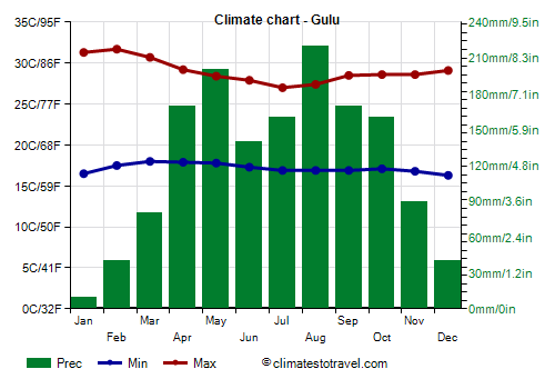
Gulu, located at 1,100 meters (3,600 feet) above sea level, the temperature can reach 36/37 °C (97/99 °F) from January to March.
As for precipitation, there is a single rainy period from April to October.
In the north, the sun regularly shines in the dry season, while in the rainy season, the hours of sunshine decrease a little.
In the northwest, around Lake Albert, whose banks are located at 620 meters (2,000 feet) above sea level, and along the Albert Nile River, the
altitude drops below 1,000 meters (3,300 feet), so the heat is more intense. The western part of the Victoria Nile River, where the Murchison Falls are located, flows at an altitude lower than 700 meters (2,300 feet): here, the daytime temperatures from December to March are around 32/33 °C (90/91 °F), with peaks around 40 °C (104 °F). On the contrary, in other areas, the altitude exceeds 1,500 meters (5,000 feet), and at night, it can get cold.
Il center-south
In the
center-south, crossed by the Equator, the temperatures are more stable; however, even here, there's a slightly cooler period from June to September, when relatively cool south-eastern currents prevail, coming from the Indian Ocean and from the highlands of Tanzania.
Furthermore, as mentioned, in this area there are
two rainy periods, from March to May (called long rains) and from late September to December (called short rains), alternating with two relatively dry periods (January-February and June-August).
This happens because the sun at the Equator passes overhead twice a year (in late March and late September), and for the thermal inertia of the soil and the atmosphere, the effect continues in the following weeks.
Kampala

In the capital,
Kampala, which lies practically at the Equator, a short distance from
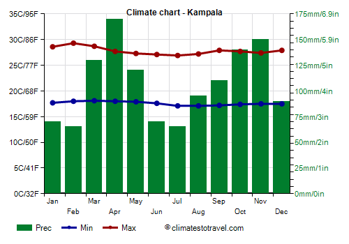
Lake Victoria and at 1,100 meters (3,600 feet), daytime temperatures range from 29 °C (84 °F) between January and March to 27 °C (81 °F) between June and August; night temperatures are even more stable, hovering around 17/18 °C (63/64 °F) throughout the year. Lake Victoria is large enough to affect the climate along its banks, reducing a bit the daily temperature range while increasing moisture.
In Kampala, precipitation amounts to 1,260 mm (50 in) per year.
The amount of sunshine is decent, but not excellent, most of the year, and decreases a bit in the "long rains season", from March to May.
Another lake of some importance is
Lake Edward, to the west, at 950 meters (3,100 ft) of altitude. At the center of the country, about 1,000 meters (3,300 feet) above sea level, we find the Kyoga and Kwania lakes, fed by the Victoria Nile, which tend to expand during rainy periods and are surrounded by swampy areas.

Mountains
In Uganda, there are
mountainous areas, with volcanoes and high mountains.
The
Ruwenzori Mountains are located in the west, near the border with the Democratic Republic of Congo, and reach their highest point in Mount Stanley, 5,109 meters (16,762 feet), which is also the third highest peak in Africa (after Kilimanjaro and Kenya). In this and other peaks of the range, above 4,500 meters (14,800 ft), glaciers are found.
Other high mountains are located in the east: Mount Elgon, 4,321 meters (14,176 feet), Mount Moroto, 3,083 meters (10,115 feet), and Mount Kadam, 3,063 meters (10,049 feet).
In addition, in the south, on the border with Rwanda and Congo, we find the
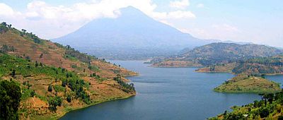
Virunga Mountains, whose highest peak (at least among those in Uganda) is Mount Muhabura, 4,127 meters (13,540 ft) high. Along the mountain slopes, there grow cloud forests, where the air is mild or cool, moisture is high, and sunshine is scarce. The
Bwindi Impenetrable National Park is located in the south-west, between 1,500 and 2,500 meters (5,000 and 8,200 ft) above sea level, and it's a UNESCO World Heritage Site, hosting the mountain gorilla, a species at risk of extinction.
Kabale

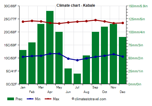
In Kabale, located near the park, at 1,900 meters (6,200 ft) above sea level, nights are cool and the days pleasantly warm, all year round.
As mentioned, the southwest is one of the driest areas of the country. In Kabale, about 1,000 mm (40 in) of rain fall per year, although the only really dry months are June and July.
The sun in Kabale does not shine very often, though at higher altitudes, as mentioned, it shines even less often.
The
Rwenzori Mountains National Park is significantly higher, since it is home to the aforementioned highest peaks of the range of the same name, and of the whole country.
When to go
Considering that the temperature is quite stable and both the intense cold and the heat rarely occur, the
best times to visit Uganda are related to the
rains.
January and February are quite dry almost everywhere, so they are the best months, although some showers may still occur, especially in the south and along the western mountain slopes, while during the day, it can get hot especially in the north and below a thousand meters (3,300 feet). It is worth while to recall that the equatorial sun's rays require appropriate protection, especially in the mountains.
In
June, July and August there is little rainfall too, but only in the south, so in these months you can go if you intend to visit Kampala, Lake Victoria and southern parks such as that of the Ruwenzori.
The rainiest months in the south are April, May, October, and November, while in the north, as mentioned above, there is a single rainy season from April to October.
What to pack
All year long, for Lake Albert and at the lowest elevations, pack light clothing, and a sweatshirt and a light jacket for the evening.
For Kampala and Lake Victoria, pack light clothes for the day, a sweater and a jacket for the evening, a light scarf for the breeze, and a light raincoat or umbrella.
For the plateau at the highest altitudes, bring spring/autumn clothes, a sweater and a warm jacket, and a raincoat or umbrella.
For the mountain peaks, warm clothes, such as a down jacket, a hat, and gloves.
Climate data - Uganda
| Arua (1,200 meters) |
|---|
|
| Jan | Feb | Mar | Apr | May | Jun | Jul | Aug | Sep | Oct | Nov | Dec |
|---|
| Min temp. | 17 | 18 | 18 | 18 | 18 | 17 | 16 | 16 | 16 | 17 | 17 | 17 |
|---|
| Max temp. | 30 | 31 | 30 | 29 | 28 | 27 | 26 | 26 | 27 | 28 | 28 | 29 |
|---|
| Precip. | 20 | 35 | 90 | 120 | 130 | 145 | 155 | 215 | 175 | 210 | 125 | 30 |
|---|
| Prec. days | 1 | 3 | 7 | 9 | 9 | 8 | 11 | 13 | 12 | 14 | 10 | 3 |
|---|
|
|
|
|
| Entebbe (1,200 meters) |
|---|
|
| Jan | Feb | Mar | Apr | May | Jun | Jul | Aug | Sep | Oct | Nov | Dec |
|---|
| Min temp. | 19 | 20 | 20 | 20 | 19 | 19 | 18 | 18 | 18 | 19 | 19 | 19 |
|---|
| Max temp. | 27 | 27 | 27 | 26 | 26 | 26 | 26 | 26 | 27 | 26 | 26 | 26 |
|---|
| Precip. | 85 | 85 | 185 | 265 | 255 | 115 | 70 | 80 | 80 | 130 | 170 | 120 |
|---|
| Prec. days | 7 | 7 | 13 | 17 | 16 | 9 | 7 | 6 | 7 | 11 | 14 | 10 |
|---|
| Humidity | 77% | 78% | 80% | 82% | 83% | 81% | 80% | 81% | 80% | 81% | 82% | 81% |
|---|
| Day length | 12 | 12 | 12 | 12 | 12 | 12 | 12 | 12 | 12 | 12 | 12 | 12 |
|---|
| Sun hours | 8 | 7 | 7 | 6 | 6 | 6 | 6 | 6 | 6 | 7 | 7 | 7 |
|---|
|
| Gulu (1,100 meters) |
|---|
|
| Jan | Feb | Mar | Apr | May | Jun | Jul | Aug | Sep | Oct | Nov | Dec |
|---|
| Min temp. | 16 | 18 | 18 | 18 | 18 | 17 | 17 | 17 | 17 | 17 | 17 | 16 |
|---|
| Max temp. | 31 | 32 | 31 | 29 | 28 | 28 | 27 | 27 | 28 | 29 | 29 | 29 |
|---|
| Precip. | 10 | 40 | 80 | 170 | 200 | 140 | 160 | 220 | 170 | 160 | 90 | 40 |
|---|
| Prec. days | 1 | 3 | 6 | 9 | 9 | 9 | 10 | 12 | 10 | 10 | 6 | 3 |
|---|
|
|
| Sun hours | 9 | 9 | 8 | 8 | 8 | 8 | 6 | 6 | 8 | 8 | 8 | 9 |
|---|
|
| Kabale (1,900 meters) |
|---|
|
| Jan | Feb | Mar | Apr | May | Jun | Jul | Aug | Sep | Oct | Nov | Dec |
|---|
| Min temp. | 10 | 11 | 11 | 12 | 12 | 10 | 9 | 10 | 10 | 11 | 12 | 11 |
|---|
| Max temp. | 24 | 24 | 24 | 24 | 23 | 24 | 24 | 24 | 25 | 24 | 23 | 24 |
|---|
| Precip. | 65 | 80 | 115 | 140 | 100 | 30 | 20 | 55 | 100 | 110 | 115 | 90 |
|---|
| Prec. days | 8 | 10 | 13 | 16 | 10 | 3 | 2 | 6 | 11 | 13 | 16 | 10 |
|---|
|
|
| Sun hours | 5 | 6 | 5 | 5 | 4 | 6 | 6 | 5 | 6 | 5 | 5 | 4 |
|---|
|
| Kampala (1,200 meters) |
|---|
|
| Jan | Feb | Mar | Apr | May | Jun | Jul | Aug | Sep | Oct | Nov | Dec |
|---|
| Min temp. | 18 | 18 | 18 | 18 | 18 | 18 | 17 | 17 | 17 | 17 | 18 | 18 |
|---|
| Max temp. | 29 | 29 | 29 | 28 | 27 | 27 | 27 | 27 | 28 | 28 | 27 | 28 |
|---|
| Precip. | 70 | 65 | 130 | 170 | 120 | 70 | 65 | 95 | 110 | 140 | 150 | 90 |
|---|
| Prec. days | 5 | 5 | 10 | 12 | 11 | 6 | 5 | 7 | 9 | 9 | 8 | 7 |
|---|
|
|
| Sun hours | 7 | 7 | 6 | 6 | 6 | 7 | 7 | 7 | 7 | 7 | 7 | 7 |
|---|
|
| Kasese (970 meters) |
|---|
|
| Jan | Feb | Mar | Apr | May | Jun | Jul | Aug | Sep | Oct | Nov | Dec |
|---|
| Min temp. | 16 | 17 | 17 | 18 | 17 | 17 | 16 | 17 | 17 | 16 | 17 | 16 |
|---|
| Max temp. | 31 | 31 | 31 | 30 | 29 | 30 | 29 | 30 | 30 | 29 | 29 | 29 |
|---|
| Precip. | 30 | 40 | 85 | 130 | 100 | 45 | 35 | 70 | 90 | 115 | 105 | 60 |
|---|
|
|
|
|
|
| Masindi (1,150 meters) |
|---|
|
| Jan | Feb | Mar | Apr | May | Jun | Jul | Aug | Sep | Oct | Nov | Dec |
|---|
| Min temp. | 17 | 17 | 18 | 18 | 17 | 17 | 16 | 16 | 16 | 16 | 16 | 16 |
|---|
| Max temp. | 30 | 30 | 30 | 28 | 27 | 27 | 26 | 26 | 27 | 27 | 27 | 28 |
|---|
| Precip. | 35 | 45 | 115 | 165 | 145 | 80 | 105 | 150 | 150 | 170 | 130 | 55 |
|---|
| Prec. days | 4 | 5 | 10 | 14 | 12 | 8 | 10 | 12 | 14 | 15 | 12 | 6 |
|---|
|
|
|
|
| Mbarara (1,450 meters) |
|---|
|
| Jan | Feb | Mar | Apr | May | Jun | Jul | Aug | Sep | Oct | Nov | Dec |
|---|
| Min temp. | 14 | 14 | 14 | 14 | 14 | 14 | 13 | 14 | 14 | 14 | 14 | 14 |
|---|
| Max temp. | 27 | 27 | 27 | 26 | 26 | 27 | 27 | 27 | 27 | 26 | 26 | 26 |
|---|
| Precip. | 55 | 55 | 95 | 120 | 70 | 25 | 25 | 70 | 110 | 130 | 130 | 75 |
|---|
| Prec. days | 6 | 6 | 10 | 12 | 7 | 2 | 2 | 6 | 9 | 12 | 14 | 8 |
|---|
|
|
|
|
| Soroti (1,130 meters) |
|---|
|
| Jan | Feb | Mar | Apr | May | Jun | Jul | Aug | Sep | Oct | Nov | Dec |
|---|
| Min temp. | 18 | 19 | 19 | 19 | 18 | 18 | 18 | 18 | 18 | 18 | 18 | 18 |
|---|
| Max temp. | 32 | 32 | 31 | 30 | 29 | 29 | 28 | 29 | 30 | 30 | 30 | 31 |
|---|
| Precip. | 70 | 65 | 130 | 170 | 120 | 70 | 65 | 95 | 110 | 140 | 150 | 90 |
|---|
|
|
|
|
|
| Tororo (1,200 meters) |
|---|
|
| Jan | Feb | Mar | Apr | May | Jun | Jul | Aug | Sep | Oct | Nov | Dec |
|---|
| Min temp. | 16 | 16 | 17 | 17 | 17 | 16 | 16 | 16 | 16 | 16 | 16 | 16 |
|---|
| Max temp. | 31 | 31 | 30 | 29 | 28 | 28 | 28 | 28 | 29 | 29 | 29 | 30 |
|---|
| Precip. | 60 | 75 | 140 | 225 | 215 | 110 | 90 | 115 | 115 | 135 | 125 | 75 |
|---|
| Prec. days | 6 | 8 | 11 | 16 | 17 | 11 | 9 | 11 | 11 | 14 | 12 | 7 |
|---|
|
|
|
|
See also the
temperatures month by month