Select units of measurement for the temperature and rainfall tables (metric or imperial).
Average weather, temperature, rainfall, sunshine
In the Philippines, an archipelago of Southeast Asia, consisting of thousands of islands and extending from 5 to 20 degrees north latitude, the climate is generally
tropical maritime, with a relatively cool season from December to February, when the north-east trade winds prevail, and a hot, humid and rainy season from May to October, when the
south-west monsoon prevails.
Some areas (usually the eastern coast, facing the Philippine Sea), have an
equatorial climate, ie rainy throughout the year. In fact, during winter, the northeast trade winds release large amounts of moisture as rain on the exposed coasts and slopes. This, in general, rarely happens on the inner islands, which are more sheltered, and even less along the western slopes, where winter is a dry season.
Between March and May, before the arrival of the summer monsoon,
the temperature increases and reaches the highest levels of the year, especially in the center-north and in the interior of the larger islands. In general the coolest month (or the least hot) is January, while the warmest is May.
In the north of Luzon,
cool air masses can sometimes arrive from December to March, so much so that at night the temperature can drop to around 12/15 °C (54/59 °F). On the southernmost islands, close to the Equator, temperatures are more stable, and remain high all year round.
Relative humidity in the Philippines is almost always high, and makes the heat muggy, at least in the lowlands.
The
sea in the Philippines is warm enough for swimming all year round.
The tropical rains typically occur in the form of downpours or thunderstorms, except during
tropical storms and typhoons (see below), which can last for a few days and are accompanied by strong winds.
The climate in detail
Equatorial climate
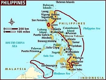
In summer, it rains all over the Philippines; the equatorial climate zones are those in which
it rains even in winter, that is, those exposed to the northeast winds.
They are the eastern part of the island of Luzon, some of the Eastern Visayas, such as the island of Samar and the eastern part of Leyte, the north-east of Mindanao and the smaller southern islands.
In these areas, more than 100 millimeters (4 inches) of rain fall per month even in winter, which is often the rainiest season. In fact, these areas, just because they are exposed to the
north-easterly winds, are generally at least partially sheltered from the summer monsoon, which as mentioned blows from the south-west. In these areas, the annual precipitation exceeds 2,500 mm (98 in), but in most of the eastern coast it exceeds 3,000 mm (118 in), and in some cases it can even exceed 4.000 mm (157 in).
Being rainy throughout the year, these areas of the Philippines honestly do not have a beautiful climate, and not surprisingly here
you won't find large cities.
The least rainy period varies depending on area, and as weeks pass it advances proceeding from north to south: in Legazpi (Luzon Island), rainfall drops below 200 mm (8 in) per month in April and May, while in Borongan (Samar Island), this happens from July to September.
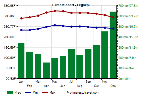 Legazpi
, located in the southeastern part of the island of Luzon, receives 3,600 mm (141.5 in) of rainfall annually.
In Legazpi, temperatures are high all year round, however, they decrease a little from December to February.
Despite the frequent rains, the sun in Legazpi shines for an acceptable number of hours, especially in the least rainy season.
The
southernmost islands (Basilan, Sulu, Tawi-Tawi), which lie north of Borneo, must be put into the equatorial climate zone, ie where it rains even in winter, but since it doesn't rain too much in this season, you can visit them from February to April, and after all even from June to September, when, however, it rains on average every other day.
Tropical climate
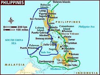
In the rest of the Philippines, the climate can be defined as tropical, since it is possible to identify a
dry season, which usually runs from February to April, but in the most sheltered areas the rains are rare even in December and January.
The dry season is more evident in the western part (blue area), while it's less evident, but still present, in the central part (green area); in contrast, the summer monsoon is generally more intense in the western part.
In this area, the
main cities of the Philippines are found, starting from the capital, Manila.
Batanes and Babuyan
The
northernmost islands (Batanes and Babuyan) are located far to the north, almost at the Tropic; in winter, they are affected by cool air masses from the Asian continent, so the weather is pretty cool from December to February, with average highs around 24/25 °C (75/77 °F).
Sometimes, from December to February, there can be days a bit cool, with lows around 15 °C (59 °F) and highs around 20 °C (68 °F) or even slightly below.
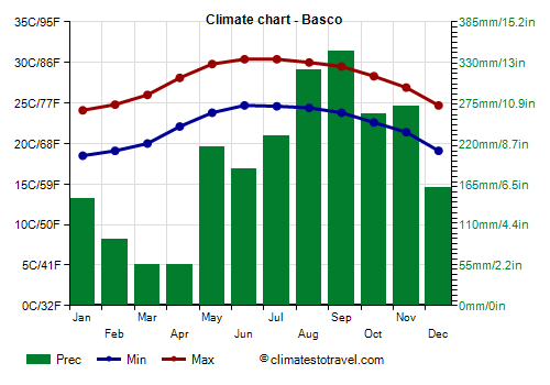
In
Basco, located in the far north of the Philippines, in the Batanes Province, the average temperature ranges from 21 °C (70 °F) in January to 27.5 °C (81.5 °F) in June and July.
From the point of view of the rains, these islands are in the intermediate area, the one circled in green.
The wettest period is from July to December, but even January is often very rainy, in fact, in this month the rains still amount to 145 mm (5.7 in).
It goes a bit better in February, but the driest months here are March and April, so they will be the ones to be preferred for a visit.
In the
interior of the northern island of
Luzon, the increase in temperature before the monsoon, i.e. from March to May, is fairly noticeable: there are hot cities like Angeles, San Fernando, Tarlac, Cabanatuan and Tuguegarao, which in this period easily reach 35/37 °C (95/99 °F), but with peaks of 40 °C (104 °F).
The metropolitan area of
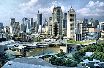
Manila and Quezon City is located in a better position because it is situated on the coast, and therefore it gets some breezes, however, being a big city, the so-called
urban heat island effect is evident. In addition, Manila is located on a bay, while to the southeast is the Laguna de Bay, which provides additional humidity.
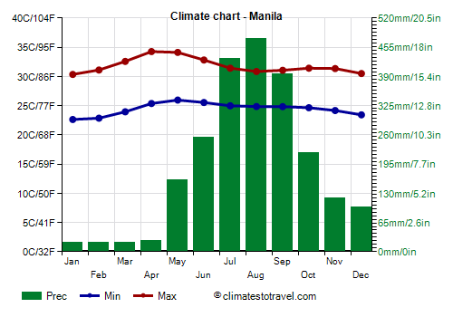
In Manila and Quezon City, it's hot all year round, since the maximum temperature is around 30 °C (86 °F) even in winter.
The hottest months are April and May, when the average maximum temperature is around 34 °C (93 °F) during the day.
During the rainy season, from June to October, the average highs drop to around 31/32 °C (88/90 °F), although night temperatures remain high, around 25/26 °C (77/79 °F), and the higher humidity makes the heat muggy.
The
dry season, from January to April, is very pronounced, in fact, it rains very rarely. The rainiest months is August, with about 475 mm (18.5 in) on average.
The amount of sunshine in Manila is better in the dry period, while during the rainy season, the sun shines on average for a few hours a day.
The best months to visit Manila are January and February, since they are the least hot within the dry period.
On the island of
Boracay, located at 300 km (190 miles) south of Manila, approximately 2,500 mm (98 in) or rain fall per year; the rains are abundant from May to October, while from January to April it rarely rains. Already in December, however, showers and thunderstorms become quite rare (on average, 6 per month).
In
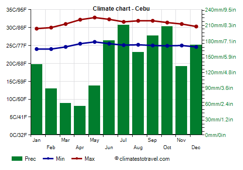
Cebu City, located 580 km (360 mi) southeast of Manila, the temperatures are high throughout the year, although they are slightly lower from December to February.
Compared to Manila, the heat is less intense in the period before the monsoon, and on the hottest days, the temperature generally reaches 35 °C (95 °F) from April to June.
Cebu City is located in the group of the central islands (
Visayas), which are more sheltered, so they are moderately rainy but without excesses. Here, about 1,650 mm (66 in) of rain fall per year, of which less than 100 mm (4 in) fall from February to May. For several months of the year, it rains on average every second day, except during the period from January to May.
We are in the intermediate zone (the one circled in green), where the dry period is present but less pronounced, January is still a pretty rainy month, and therefore the best period is from February to April.
The sun in Cebu frequently shines in the dry season, while in the rest of the year it does not shine too often.
 Davao City
 is located in the south of Mindanao, overlooking the gulf of the same name, and a short distance from mountains such as Apo and Leonard Kniaseff.
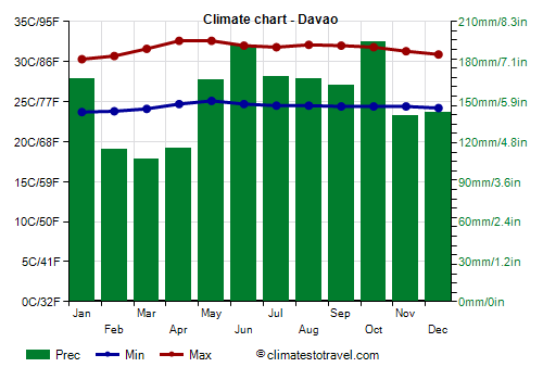
Although it is not directly exposed to the east coast and therefore it is not as rainy as Legazpi, the climate here should be defined as equatorial because there is no dry season: 1,835 mm 80 in) of rain fall per year, with a minimum between February and April of 105/115 mm (4.1/4.5 in) per month.
The least rainy area of the Philippines is the protected Sarangani Bay, in the far south of Mindanao. In
General Santos, 960 mm (37.7 in) of rain fall per year, with a maximum of about 100 mm (4 in) per month, and therefore not a large amount, in the summer months.
Even in the south-west of Mindanao, in
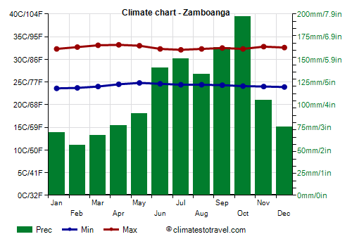
Zamboanga, the rainfall is not very abundant, in fact it amounts to 1,325 mm (52 in) per year.
Mountains
In the Philippines, there are many mountains and volcanoes, the highest of which is the aforementioned Mount Apo, in Mindanao, 2,954 meters (9,691 ft) high. The summit is above the tree line (which needs at least three months to grow with an average temperature above 10 °C or 50 °F), in fact the average temperature ranges from 7 °C (44.5 °F) in January to 9 °C (48 °F) in April.
Along the mountain slopes, usually
the rains are more abundant than in the plains, and as mentioned, on the slopes exposed to the wind, showers and thunderstorms are possible throughout the year.
In
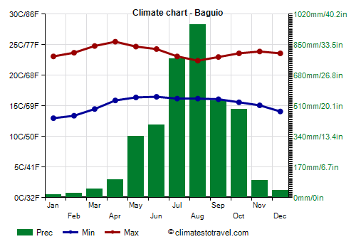
Baguio, at 1,500 meters (5,000 feet) above sea level, on the island of Luzon, 3,800 mm (152 in) of rain fall per year; the rains are plentiful especially in July and August, with almost one meter (3.3 feet) of rain per month!
However, there is little rain from December to March, in addition, there are
mild temperatures thanks to the altitude, so Baguio is a haven to escape the heat of the cities, especially in the hottest period of the year, ie in March and April, before the rainy season.
From December to February, on colder nights, the temperature typically drops to around 10 °C (50 °F).
During the day, sometimes the maximum can remain around 18/19 °C (64.5/66 °F), both in winter, during the cooler periods, and in summer, due to rain and cloudy skies.
On the hottest days of the year, the temperature typically reaches 30 °C (86 °F) from April to June.
The sun in Baguio shines often in the dry season, although fog can form at night and in the early morning, while in the rainy season it can be seen for a few hours a day.
Typhoons
The Philippines is one of the countries most affected by tropical cyclones, which in south-east Asia are called
typhoons. The only area that generally remains outside of their trajectory is the southernmost one, ie the island of Mindanao, especially in the central and southern part, the south of Palawan and the small southernmost islands.
Typically, typhoons occur from May to December, although they are more frequent between August and November.
Sometimes, destructive typhoons occurred even in December, for example, Typhoon Bopha, which affected the Philippines in early December 2012, Typhoon Hagupit, which struck the islands around December 10, 2014, Typhoon Tembin, which hit Mindanao from 20 to 25 December 2017, and Typhoon Rai (also called super typhoon Odette), which hit the north of Mindanao and the central islands from 16 to 19 December 2021.
Since the sea is always warm, typhoons can in theory occur even from January to April, although in general, during this period, only tropical depressions not intense are formed, which can sometimes release considerable amounts of rain anyway, especially on the eastern slopes.
El Niño
The Philippines are also affected by the phenomenon known as
El Niño, which during some years alters the climate of large areas of the world, and in the Philippines brings heat, drought and fewer typhoons than usual, while the opposite phenomenon,
La Niña, brings heavier rainfall than normal and slightly lower temperatures.
When to go
The best time to visit the Philippines as a whole runs from
February to April, since in the regions with an equatorial climate, which in any case are rainy all year round, January is a particularly rainy month. March and April are very hot months, so February is the best month of all.
In the areas with a tropical climate, where the winter drought is evident, such as in Manila,
January is also a good month; and it's often the best one because it is dry and also the least hot.
If you want to go in
July or August, you can prefer the south of Mindanao (see Zamboanga, General Santos) and the southernmost islands (Basilan, Sulu, Tawitawi), which are less rainy and therefore are acceptable even in this period, and above all are generally sheltered from typhoons.
As mentioned above, the
sea is warm enough for swimming all year round.
What to pack
In
winter: on the northernmost islands (Batanes and Babuyan), bring spring/autumn clothes (light for the day), but also a sweatshirt or sweater and a jacket; a raincoat or umbrella. In the north of Luzon, light clothing, a sweatshirt or sweater for the evening, a raincoat or umbrella. In Manila and the rest of the Philippines, pack light clothing, made of natural fibers, a scarf for the breeze, a light sweatshirt for air-conditioned places, a light raincoat or umbrella for the areas where it rains even in winter. In Baguio, at 1,500 meters (5,000 feet), spring/autumn clothes (light for the day), a jacket and a sweater for the evening. For the high mountains, warmer clothes depending on altitude.
In
summer: throughout the plains and the coasts, bring tropics-friendly clothing, a scarf for the breeze, a light sweatshirt for air-conditioned places, a light raincoat or umbrella. In Baguio, at 1,500 meters (5,000 feet), spring/autumn clothes, a jacket and a sweater for the evening, a raincoat. For the high mountains, warmer clothes depending on altitude.
When going to the reef, you can bring snorkeling equipment, including water shoes or rubber-soled shoes.
Climate data - Philippines
| Baguio (1,500 meters) |
|---|
|
| Jan | Feb | Mar | Apr | May | Jun | Jul | Aug | Sep | Oct | Nov | Dec |
|---|
| Min temp. | 13 | 13 | 14 | 16 | 16 | 16 | 16 | 16 | 16 | 16 | 15 | 14 |
|---|
| Max temp. | 23 | 24 | 25 | 26 | 25 | 24 | 23 | 22 | 23 | 24 | 24 | 24 |
|---|
| Precip. | 15 | 25 | 50 | 100 | 340 | 405 | 775 | 965 | 535 | 490 | 95 | 40 |
|---|
| Prec. days | 2 | 2 | 4 | 8 | 18 | 20 | 24 | 25 | 22 | 13 | 7 | 4 |
|---|
| Humidity | 85% | 84% | 84% | 85% | 88% | 89% | 91% | 92% | 91% | 89% | 86% | 85% |
|---|
| Day length | 11 | 12 | 12 | 12 | 13 | 13 | 13 | 13 | 12 | 12 | 11 | 11 |
|---|
| Sun hours | 6 | 7 | 7 | 7 | 6 | 5 | 4 | 4 | 4 | 5 | 5 | 5 |
|---|
|
| Basco |
|---|
|
| Jan | Feb | Mar | Apr | May | Jun | Jul | Aug | Sep | Oct | Nov | Dec |
|---|
| Min temp. | 18 | 19 | 20 | 22 | 24 | 25 | 25 | 24 | 24 | 23 | 21 | 19 |
|---|
| Max temp. | 24 | 25 | 26 | 28 | 30 | 30 | 30 | 30 | 30 | 28 | 27 | 25 |
|---|
| Precip. | 145 | 90 | 55 | 55 | 215 | 185 | 230 | 320 | 345 | 260 | 270 | 160 |
|---|
| Prec. days | 15 | 9 | 7 | 5 | 11 | 12 | 13 | 16 | 17 | 14 | 16 | 15 |
|---|
|
|
|
| Sea temp | 25 | 25 | 26 | 27 | 28 | 29 | 30 | 29 | 29 | 28 | 27 | 26 |
|---|
| Bongao |
|---|
|
| Jan | Feb | Mar | Apr | May | Jun | Jul | Aug | Sep | Oct | Nov | Dec |
|---|
| Min temp. | 23 | 23 | 23 | 23 | 23 | 23 | 23 | 23 | 23 | 23 | 23 | 23 |
|---|
| Max temp. | 30 | 30 | 31 | 31 | 31 | 31 | 30 | 30 | 31 | 31 | 31 | 31 |
|---|
| Precip. | 210 | 175 | 135 | 150 | 210 | 190 | 170 | 145 | 150 | 215 | 200 | 210 |
|---|
| Prec. days | 14 | 11 | 11 | 10 | 13 | 16 | 15 | 15 | 15 | 17 | 16 | 16 |
|---|
|
|
|
|
| Cebu City |
|---|
|
| Jan | Feb | Mar | Apr | May | Jun | Jul | Aug | Sep | Oct | Nov | Dec |
|---|
| Min temp. | 24 | 24 | 25 | 26 | 26 | 26 | 25 | 25 | 25 | 25 | 25 | 25 |
|---|
| Max temp. | 30 | 30 | 31 | 32 | 33 | 32 | 32 | 32 | 32 | 31 | 31 | 30 |
|---|
| Precip. | 135 | 90 | 60 | 55 | 95 | 180 | 210 | 160 | 190 | 210 | 130 | 170 |
|---|
| Prec. days | 12 | 9 | 7 | 5 | 8 | 13 | 15 | 13 | 14 | 15 | 12 | 14 |
|---|
| Humidity | 83% | 81% | 79% | 77% | 78% | 81% | 83% | 82% | 82% | 83% | 83% | 84% |
|---|
| Day length | 12 | 12 | 12 | 12 | 13 | 13 | 13 | 12 | 12 | 12 | 12 | 12 |
|---|
| Sun hours | 7 | 7 | 8 | 9 | 8 | 6 | 6 | 6 | 6 | 6 | 6 | 7 |
|---|
| Sea temp | 27 | 27 | 27 | 28 | 29 | 30 | 29 | 29 | 29 | 29 | 29 | 28 |
|---|
| Davao City |
|---|
|
| Jan | Feb | Mar | Apr | May | Jun | Jul | Aug | Sep | Oct | Nov | Dec |
|---|
| Min temp. | 24 | 24 | 24 | 25 | 25 | 25 | 24 | 24 | 24 | 24 | 24 | 24 |
|---|
| Max temp. | 30 | 31 | 32 | 33 | 33 | 32 | 32 | 32 | 32 | 32 | 31 | 31 |
|---|
| Precip. | 165 | 115 | 105 | 115 | 165 | 195 | 170 | 165 | 160 | 195 | 140 | 140 |
|---|
| Prec. days | 11 | 9 | 9 | 9 | 13 | 14 | 13 | 12 | 11 | 12 | 12 | 11 |
|---|
| Humidity | 81% | 78% | 77% | 76% | 80% | 81% | 81% | 80% | 80% | 79% | 81% | 81% |
|---|
| Day length | 12 | 12 | 12 | 12 | 12 | 12 | 12 | 12 | 12 | 12 | 12 | 12 |
|---|
|
| Sea temp | 28 | 28 | 28 | 29 | 30 | 30 | 29 | 29 | 29 | 29 | 29 | 29 |
|---|
| Legazpi |
|---|
|
| Jan | Feb | Mar | Apr | May | Jun | Jul | Aug | Sep | Oct | Nov | Dec |
|---|
| Min temp. | 23 | 23 | 24 | 25 | 26 | 25 | 25 | 25 | 25 | 24 | 24 | 24 |
|---|
| Max temp. | 29 | 29 | 30 | 32 | 32 | 32 | 32 | 32 | 32 | 31 | 30 | 29 |
|---|
| Precip. | 345 | 250 | 230 | 150 | 200 | 215 | 280 | 220 | 280 | 320 | 450 | 640 |
|---|
| Prec. days | 18 | 13 | 14 | 12 | 13 | 14 | 18 | 16 | 17 | 18 | 20 | 22 |
|---|
| Humidity | 85% | 83% | 83% | 82% | 82% | 83% | 85% | 84% | 85% | 85% | 86% | 87% |
|---|
| Day length | 12 | 12 | 12 | 12 | 13 | 13 | 13 | 12 | 12 | 12 | 12 | 11 |
|---|
| Sun hours | 6 | 6 | 8 | 8 | 8 | 7 | 6 | 6 | 6 | 6 | 6 | 6 |
|---|
| Sea temp | 27 | 27 | 27 | 28 | 29 | 30 | 30 | 29 | 29 | 29 | 28 | 28 |
|---|
| Manila |
|---|
|
| Jan | Feb | Mar | Apr | May | Jun | Jul | Aug | Sep | Oct | Nov | Dec |
|---|
| Min temp. | 23 | 23 | 24 | 25 | 26 | 26 | 25 | 25 | 25 | 25 | 24 | 23 |
|---|
| Max temp. | 30 | 31 | 33 | 34 | 34 | 33 | 31 | 31 | 31 | 31 | 31 | 30 |
|---|
| Precip. | 20 | 20 | 20 | 25 | 160 | 255 | 430 | 475 | 395 | 220 | 120 | 100 |
|---|
| Prec. days | 4 | 3 | 3 | 3 | 9 | 14 | 19 | 19 | 18 | 14 | 10 | 8 |
|---|
| Humidity | 74% | 71% | 68% | 66% | 73% | 78% | 83% | 85% | 85% | 81% | 78% | 77% |
|---|
| Day length | 11 | 12 | 12 | 12 | 13 | 13 | 13 | 13 | 12 | 12 | 12 | 11 |
|---|
| Sun hours | 7 | 8 | 8 | 9 | 8 | 7 | 7 | 6 | 6 | 6 | 7 | 6 |
|---|
| Sea temp | 28 | 27 | 28 | 29 | 30 | 30 | 30 | 29 | 29 | 29 | 29 | 28 |
|---|
| Zamboanga |
|---|
|
| Jan | Feb | Mar | Apr | May | Jun | Jul | Aug | Sep | Oct | Nov | Dec |
|---|
| Min temp. | 24 | 24 | 24 | 24 | 25 | 25 | 24 | 24 | 24 | 24 | 24 | 24 |
|---|
| Max temp. | 32 | 33 | 33 | 33 | 33 | 32 | 32 | 32 | 32 | 32 | 33 | 33 |
|---|
| Precip. | 70 | 55 | 65 | 75 | 90 | 140 | 150 | 135 | 165 | 195 | 105 | 75 |
|---|
| Prec. days | 7 | 6 | 6 | 7 | 9 | 12 | 12 | 10 | 11 | 13 | 10 | 8 |
|---|
| Humidity | 79% | 77% | 77% | 78% | 80% | 81% | 81% | 80% | 81% | 81% | 80% | 79% |
|---|
| Day length | 12 | 12 | 12 | 12 | 12 | 12 | 12 | 12 | 12 | 12 | 12 | 12 |
|---|
| Sun hours | 7 | 8 | 7 | 7 | 7 | 5 | 6 | 7 | 6 | 6 | 7 | 7 |
|---|
| Sea temp | 28 | 28 | 28 | 29 | 29 | 29 | 29 | 29 | 29 | 29 | 29 | 29 |
|---|
See also the
temperatures month by month