Select units of measurement for the temperature and rainfall tables (metric or imperial).
Average weather, temperature, rainfall, sunshine
The climate in the archipelago of Palau (or Belau) is
equatorial, that is, hot, humid and rainy throughout the year. In fact, there is no real dry season, but only a relative decrease in the frequency of showers and thunderstorms between February and April.
The archipelago is located in the western Pacific, north of the equator. The main island,
Babeldaob, is located about 900 km (560 mi) east of the island of Mindanao (Philippines) and at 7 degrees north latitude. The capital,
Ngerulmud, is located on the main island, while the largest city is
Koror City, located on a neighboring island, Oreor (or Koror).
The climate in detail
Temperature and rain
Koror

In
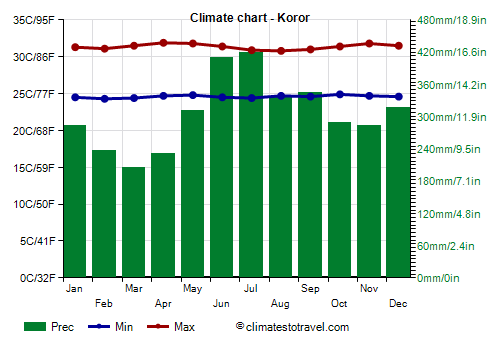
Koror City, the daytime temperature is around 31 °C (88 °F) all year round, while it's around 24 °C (75 °F) at night. At night, the temperature never drops below 20 °C (68 °F). On the hottest days, the temperature usually reaches 33/34 °C (91/93 °F) from March to May, and also in October and November. The highest record is 35 °C (95 °F) and was set in March 2018.
The
rains are plentiful, and amount to around 3,700 millimeters (146 inches) per year. The rainiest months are June and July, with more than 400 mm (15.5 in) per month.
The amount of
sunshine is acceptable from February to May, and lessens a bit from June to December, when showers occur almost daily. However, the sun almost always shines for a few hours a day, except when a typhoon reaches the islands (see below). On average, there are 2,350 hours of sunshine per year.

Sea temperature
The sea in Palau is warm enough to swim in all year round, and has a very stable temperature, from 28 to 29 °C (82.5 to 84 °F).
Tropical cyclones
Palau can be hit by
typhoons, ie the tropical cyclones of south-east Asia, which reach the country and then move towards the Philippines.
Typhoons, along with the less intense tropical storms, bring rains and strong winds, and normally occur between April and December, though they are more frequent between August and November.
However, since the sea is always warm, they can sometimes also occur from January to March, although, during this period, only not intense tropical depressions are usually formed.
Typically, the most intense typhoons
pass further north, or become intense after affecting Palau and on their way to the Philippines. However, some typhoons that affected Palau at a notable level of intensity were Mike in November 1990, Bopha in early December 2012, and Haiyan in early December 2013.
On the contrary, the south-western islands (see the states of Sonsorol and Hatohobei), being near the Equator, are protected from typhoons, or at most, they may be marginally affected.
When to go
The best time to visit Palau runs from
February to April, since it's the least rainy and the sunniest period of the year. Even in this period, however, showers and thunderstorms must be put into account, but they do not last long, so they soon give way to the sun.
What to pack
All year round, bring
tropics-friendly, loose-fitting clothing, a sun hat, a scarf for the breeze, a light sweatshirt for the evening, and a light raincoat or umbrella.
When going to the reef, you can bring snorkeling equipment, including water shoes or rubber-soled shoes.
Climate data - Palau
| Koror |
|---|
|
| Jan | Feb | Mar | Apr | May | Jun | Jul | Aug | Sep | Oct | Nov | Dec |
|---|
| Min temp. | 24 | 24 | 24 | 25 | 25 | 24 | 24 | 25 | 25 | 25 | 25 | 25 |
|---|
| Max temp. | 31 | 31 | 32 | 32 | 32 | 31 | 31 | 31 | 31 | 31 | 32 | 32 |
|---|
| Precip. | 285 | 235 | 205 | 230 | 310 | 410 | 420 | 335 | 345 | 290 | 285 | 315 |
|---|
| Prec. days | 18 | 16 | 15 | 16 | 21 | 22 | 21 | 19 | 18 | 18 | 20 | 21 |
|---|
| Humidity | 83% | 83% | 82% | 83% | 84% | 85% | 85% | 83% | 83% | 83% | 84% | 84% |
|---|
| Day length | 12 | 12 | 12 | 12 | 12 | 12 | 12 | 12 | 12 | 12 | 12 | 12 |
|---|
| Sun hours | 6 | 7 | 8 | 8 | 7 | 6 | 6 | 6 | 7 | 6 | 6 | 6 |
|---|
| Sea temp | 28 | 28 | 28 | 29 | 29 | 29 | 29 | 29 | 29 | 29 | 29 | 29 |
|---|