Select units of measurement for the temperature and rainfall tables (metric or imperial).
Average weather, temperature, rainfall, sunshine
Romania, an Eastern European country, has generally a
continental climate, with cold winters and hot summers.
The Black Sea coast has a slightly milder climate, but not by much, since it often receives air masses coming from inland.
In the long
Carpathian range, which crosses the country with a semicircular shape, the weather becomes colder and wetter with increasing altitude: in winter, snowfalls are frequent, while in summer, thunderstorms occur in the afternoon.
Precipitation (rain or snow) is not abundant, although it is well distributed over the seasons, with a maximum in May and June, mainly because of afternoon thunderstorms.
In the lowlands, precipitation amounts to 600/650 millimeters (23.5/25.5 inches) per year in most of Romania, although in the eastern part of Banat (the region near the border with Serbia and Hungary), it exceeds 700 mm (27.5 in) per year at the foot of the Carpathians.
The least rainy area is the eastern one. Precipitation is lower than 600 mm (23.5 in) per year in the Moldovan lowland and lower than 500 mm (20 in) on the Black Sea coast (see Constanta), and even drops below 300 mm (12 in) per year in the Danube delta area, near the border with Ukraine.
In Romania, there is not much
sun in winter, while in summer, the sun shines quite often. On average, there are 1,900/2,000 hours of sunshine per year in the north and in the valleys of Transylvania, 2,100/2,200 hours in the southern plain, and 2,300/2,400 hours on the coast.
The climate in detail
The seasons
Winter, from December to February, is cold throughout Romania. Cold air stagnates in the lowest layers of the atmosphere, and the sky is often cloudy. Snowfall is quite common, but not abundant; in inland plains, there are about thirty days with snowfall per year. In Bucharest, the ground is often covered with snow.
During winter, temperatures are fairly uniform across the continental region, and decrease mainly with increasing altitude. In the main cities located around sea level (Bucharest,
Timisoara,
Iasi,
Craiova,
Galati etc.), the average daily temperature in January hovers between 0 °C (32 °F) and -2 °C (28.5 °F). In Bucharest, the average is -1 °C (30 °F).
On the
Transylvanian Plateau, west of the Carpathians, winter is slightly colder: in Cluj-Napoca, Bistrita and Sibiu, located at 400 meters (1,300 feet) above sea level, the average in January is -2/-2.5 °C (27/28 °F).
During winter, the mildest lowland area of Romania is
Dobrudja, the stretch of plain between the Danube and the Black Sea. On the coast (see Constanta), the average temperature in January is just above freezing, around 1.5 °C (35 °F).
Romania, like other parts of the Balkan Peninsula, is exposed to outbreaks of
cold air masses from northern Europe or Russia, most likely from late November to mid-March.
They can lower the temperatures to -15 °C (5 °F) or below on the coast and to -25 °C (-4 °F) or below in inland areas, however, they used to be more frequent in the past decades, when the climate was colder. The coldest area is Transylvania, the region surrounded by the Carpathians. Romania's coldest record is -38.5 degrees Celsius (-37.5 °F), recorded in Bod, Brasov County, in January 1942, an in Miercurea Ciuc in January 1985.
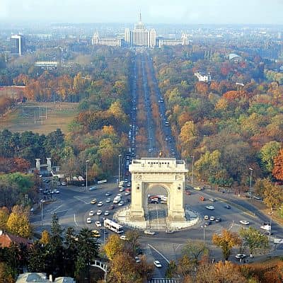
The
summer, from June to August, is hot, especially in the plains and inland areas.
Summer is warm in the north, in the plains and hills of Transylvania and in the region east of the Carpathians, on the border with Moldova: in Cluj-Napoca and Sibiu, around 400 meters (1,300 feet) above sea level, highs are around 27 °C (80.5 °F), while in Iasi, near the border with Moldova, they are around 29 °C (88 °F).
South of the Carpathians, the region of
Wallachia, where Bucharest is located, is warmer, and it's often hot: here, the maximum temperatures in July and August are 30/31 °C (86/88 °F) on average.
Along coast of the Black Sea, the weather in summer is nice and pleasantly warm, sometimes even hot, but tempered by the breeze.
Summer is a fairly rainy season, mainly because of
afternoon thunderstorms, which occur especially in May and July, and are most frequent and abundant in the mountains. Sometimes, these thunderstorms are so strong that they can cause floods.
The amount of
sunshine in summer is good in the lowlands, while cloud cover is more frequent in the mountains and in Transylvania, where, however, the sun often shines, especially in the morning.
In summer, Romania can be affected by
heat waves of African origin. The areas most affected are the inland plains, while Transylvania and the coast are less intensely affected. In these cases, the temperature can reach or exceed 35 °C (95 °F) on the coast and 40 °C (104 °F) in the inland plains. In the southern cities (see Bucharest, Craiova, Rosiorii de Vede, Calarasi), the temperature reached 42/42.5 °C (107.5/108.5 °F) in July 2000 and July 2007.
Wallachia
Wallachia, the
southern lowland area (see Craiova, Bucharest), has a continental climate: winter is still cold, while summer is warmer than in the rest of Romania.
Bucharest
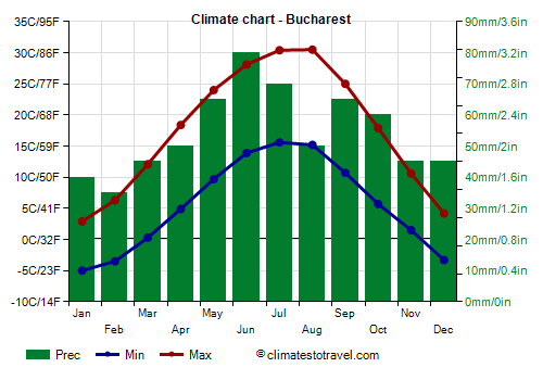
In the capital,
Bucharest, winter is cold and gray, with snowfalls and frosts. During cold spells, the temperature can drop to around -15 °C (5 °F). Summer is hot and sunny, though thunderstorms can break out in the afternoon. On hot days, the temperature can reach or exceed 35 °C (95 °F).
Precipitation amounts to 645 mm (25.5 in) per year. The wettest period is from May to August because of afternoon thunderstorms.
Transylvania
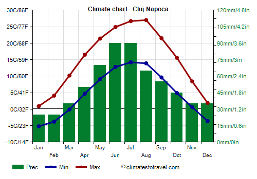
In the
Transylvanian Plateau, west of the Carpathians (see
Bistrita,
Cluj-Napoca,
Sibiu), winter is very cold, with January averages around -2 °C (28.5 °F), while summer is a little cooler because of the altitude, with July and August averages around 20 °C (68 °F).
Precipitation amounts to 620/650 mm (24/26 in) per year. Here too, the wettest period is from May to August because of afternoon thunderstorms. In winter, precipitation is weak but quite frequent, and often occurs in the form of snow.
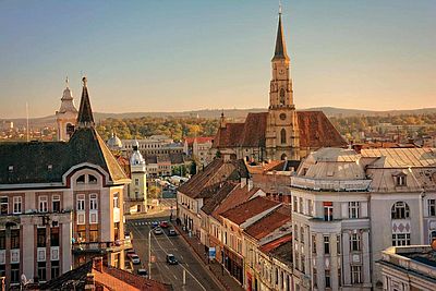
Carpathian Mountains
In the mountains, the climate becomes colder, but also more humid with increasing altitude.
In the valleys located between the mountains, thermal inversion often occurs, so it is very cold at night.
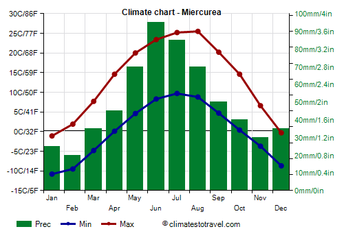
In
Miercurea Ciuc, located at 660 meters (2,200 feet), in Harghita County, the average temperature ranges from -6 °C (21 F) in January to 17.5 °C (63.5 °F) in July.
Precipitation amounts to 595 mm (23.5 in) per year, as usual, with a summer maximum due to thunderstorms.
At the
Bran Castle, which according to legend would be Dracula's castle, located at 750 meters (2,450 ft) above sea level, winters are cold and snowy, while summers are pleasant, with highs around 23 °C (73 °F) and cool nights, but also possible thunderstorms in the afternoon.

A similar climate is found in the Poenari Castle, located at 820 meters (2,700 feet) of altitude, which should be the real Dracula's Castle, aka Prince Vlad III of Wallachia.
The
Bucovina Monasteries are located at the foot of the Carpathians, in Romanian Moldavia, in the north-east of the country: during the day, it can get hot in July and August, while nights remain cool. The monasteries are located between 300 and 650 meters (1,000 and 2,100 feet) above sea level: the highest is the monastery of Moldovita, which is located at 630 meters (2,065 feet), the lowest is the monastery of Probota, which is located at 290 meters (950 feet). The others (Putna, Humor, Sucevita, Voronet, Dragomirna, Arbore) are located at intermediate altitudes.
In the
Ceahlau Massif, located in the Eastern Carpathians, at 1,900 meters (6,200 ft), the average temperature ranges from -7.5 °C (18.5 °F) in February to 12 °C (53 °F) in August.
At higher altitudes, the temperatures are even lower, and it is cold even in summer. In
Mount Omu, 2,500 meters (8,200 feet), the highest peak of the Bucegi Mountains, near the towns of Busteni and Sinaia, the average temperature ranges from -10 °C (14 °F) in January and February to 7.5 °C (45.5 °F) in August. Precipitation reaches 1,000 mm (40 inches) per year, with a maximum of 150 mm (6 in) in June.
A similar altitude is also reached further to the west, in the Fagaras Mountains, where the highest mountain in Romania is found, that is, Mount
Moldoveanu, 2,544 meters (8,346 ft) high.
The coast
On the Black Sea Coast, the climate is
slightly milder than in inland areas. However, the winter is still cold, while the summer is warm and sunny, sometimes hot, although tempered by the breeze.
In winter, a cold wind can blow, and it can snow and freeze. On colder winters, the Black Sea along the coast can even freeze, as happened in February 2012. So, winter along the coast of the Black Sea, albeit milder than in the interior, is still cold.
Constanta
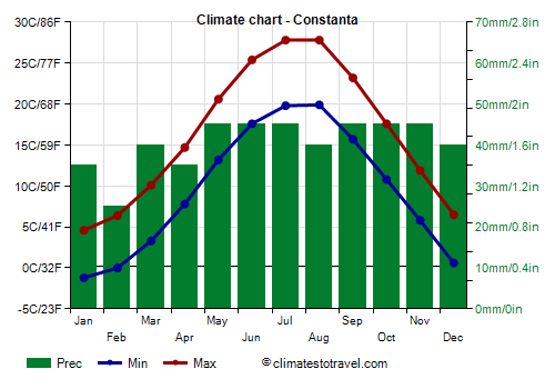
In
Constanta, the largest city of the coast, the average temperature ranges from 1.5 °C (35 °F) in January to 24 °C (75 °F) in July.
As mentioned, the Black Sea coast is the driest of the country, also because the summer thunderstorms are less frequent. In Constanta, precipitation amounts to 25 to 45 mm (1 to 1.8 in) per month throughout the year.
The temperature of the Black Sea is acceptable for swimming in summer: it's around 23 °C (73 °F) in July and 24 °C (75 °F) in August, while it is a bit cool in June and September.
When to go
The best time to visit Romania is from
May to September.
June is the rainiest month because of afternoon thunderstorms.
In
July and August, it can get hot in inland plains, especially in the south, ie in Wallachia (see Bucharest), so you can choose May, June and September, especially if you don't like the heat.
In May, the country is in bloom, and the temperature is generally pleasant, even though afternoon thunderstorms are already possible.
September is usually a pleasant and quiet month, with little rain; sometimes, warm and sunny weather lasts until October.
The
Black Sea Coast is good for a beach holiday in summer, but in winter, since it has an average temperature close to freezing and can sometimes experience wind and snowfall, it's certainly not a refuge from the cold European winter.
What to pack
In
winter: bring warm clothes, such as a sweater or fleece, a down jacket, a hat, gloves and a scarf, and a raincoat or umbrella.
In
summer: bring light clothes, t-shirts and shorts, but also long pants, a light jacket and a sweatshirt for the evening; an umbrella. Some heavier clothes for the mountains.
Climate data - Romania
| Baia Mare (250 meters) |
|---|
|
| Jan | Feb | Mar | Apr | May | Jun | Jul | Aug | Sep | Oct | Nov | Dec |
|---|
| Min temp. | -4 | -3 | 1 | 6 | 10 | 14 | 15 | 15 | 11 | 6 | 2 | -2 |
|---|
| Max temp. | 2 | 5 | 11 | 17 | 22 | 25 | 27 | 28 | 22 | 16 | 10 | 4 |
|---|
| Precip. | 60 | 45 | 40 | 55 | 70 | 85 | 70 | 55 | 70 | 50 | 60 | 80 |
|---|
| Prec. days | 9 | 8 | 7 | 8 | 8 | 9 | 7 | 6 | 7 | 6 | 8 | 10 |
|---|
| Humidity | 88% | 82% | 70% | 65% | 69% | 70% | 70% | 68% | 74% | 79% | 84% | 88% |
|---|
| Day length | 9 | 10 | 12 | 14 | 15 | 16 | 16 | 14 | 12 | 11 | 9 | 8 |
|---|
| Sun hours | 2 | 4 | 5 | 6 | 8 | 9 | 9 | 9 | 7 | 6 | 3 | 2 |
|---|
|
| Bistrita (400 meters) |
|---|
|
| Jan | Feb | Mar | Apr | May | Jun | Jul | Aug | Sep | Oct | Nov | Dec |
|---|
| Min temp. | -6 | -5 | -1 | 4 | 8 | 12 | 14 | 14 | 9 | 5 | 0 | -4 |
|---|
| Max temp. | 1 | 4 | 10 | 16 | 21 | 25 | 27 | 27 | 22 | 16 | 9 | 2 |
|---|
| Precip. | 45 | 30 | 35 | 50 | 75 | 80 | 75 | 65 | 50 | 40 | 40 | 50 |
|---|
| Prec. days | 8 | 6 | 6 | 9 | 9 | 9 | 8 | 7 | 7 | 5 | 7 | 8 |
|---|
|
| Day length | 9 | 10 | 12 | 14 | 15 | 16 | 15 | 14 | 12 | 11 | 9 | 9 |
|---|
| Sun hours | 2 | 4 | 5 | 6 | 8 | 8 | 9 | 9 | 7 | 6 | 3 | 2 |
|---|
|
| Bucharest |
|---|
|
| Jan | Feb | Mar | Apr | May | Jun | Jul | Aug | Sep | Oct | Nov | Dec |
|---|
| Min temp. | -5 | -4 | 0 | 5 | 10 | 14 | 16 | 15 | 11 | 6 | 2 | -3 |
|---|
| Max temp. | 3 | 6 | 12 | 18 | 24 | 28 | 30 | 30 | 25 | 18 | 11 | 4 |
|---|
| Precip. | 40 | 35 | 45 | 50 | 65 | 80 | 70 | 50 | 65 | 60 | 45 | 45 |
|---|
| Prec. days | 6 | 6 | 6 | 6 | 8 | 8 | 7 | 5 | 5 | 6 | 6 | 6 |
|---|
| Humidity | 87% | 80% | 70% | 65% | 66% | 65% | 61% | 60% | 65% | 77% | 84% | 88% |
|---|
| Day length | 9 | 10 | 12 | 14 | 15 | 16 | 15 | 14 | 12 | 11 | 10 | 9 |
|---|
| Sun hours | 2 | 3 | 4 | 6 | 8 | 9 | 9 | 9 | 7 | 6 | 3 | 2 |
|---|
|
| Ceahlau (1,900 meters) |
|---|
|
| Jan | Feb | Mar | Apr | May | Jun | Jul | Aug | Sep | Oct | Nov | Dec |
|---|
| Min temp. | -10 | -10 | -8 | -3 | 2 | 6 | 8 | 8 | 4 | 0 | -4 | -8 |
|---|
| Max temp. | -5 | -5 | -2 | 4 | 10 | 13 | 15 | 15 | 10 | 6 | 1 | -3 |
|---|
| Precip. | 25 | 30 | 35 | 45 | 70 | 100 | 105 | 90 | 45 | 30 | 25 | 30 |
|---|
| Prec. days | 7 | 8 | 9 | 10 | 13 | 13 | 13 | 11 | 8 | 6 | 6 | 7 |
|---|
|
|
| Sun hours | 3 | 3 | 3 | 5 | 6 | 7 | 8 | 7 | 6 | 5 | 3 | 2 |
|---|
|
| Cluj Napoca (350 meters) |
|---|
|
| Jan | Feb | Mar | Apr | May | Jun | Jul | Aug | Sep | Oct | Nov | Dec |
|---|
| Min temp. | -5 | -4 | 0 | 5 | 9 | 13 | 14 | 14 | 10 | 5 | 1 | -4 |
|---|
| Max temp. | 1 | 4 | 10 | 16 | 21 | 25 | 27 | 27 | 22 | 16 | 8 | 2 |
|---|
| Precip. | 25 | 25 | 35 | 50 | 70 | 90 | 90 | 65 | 55 | 45 | 35 | 35 |
|---|
| Prec. days | 6 | 7 | 7 | 9 | 10 | 11 | 10 | 7 | 8 | 7 | 7 | 7 |
|---|
| Humidity | 87% | 81% | 69% | 65% | 69% | 70% | 69% | 68% | 72% | 77% | 84% | 88% |
|---|
| Day length | 9 | 10 | 12 | 14 | 15 | 16 | 15 | 14 | 12 | 11 | 9 | 9 |
|---|
| Sun hours | 2 | 4 | 5 | 6 | 8 | 8 | 9 | 8 | 6 | 5 | 3 | 2 |
|---|
|
| Constanta |
|---|
|
| Jan | Feb | Mar | Apr | May | Jun | Jul | Aug | Sep | Oct | Nov | Dec |
|---|
| Min temp. | -1 | 0 | 3 | 8 | 13 | 18 | 20 | 20 | 16 | 11 | 6 | 1 |
|---|
| Max temp. | 5 | 6 | 10 | 15 | 21 | 25 | 28 | 28 | 23 | 18 | 12 | 6 |
|---|
| Precip. | 35 | 25 | 40 | 35 | 45 | 45 | 45 | 40 | 45 | 45 | 45 | 40 |
|---|
| Prec. days | 6 | 5 | 6 | 5 | 6 | 5 | 4 | 3 | 4 | 5 | 6 | 6 |
|---|
| Humidity | 85% | 84% | 83% | 80% | 79% | 75% | 74% | 75% | 77% | 80% | 84% | 86% |
|---|
| Day length | 9 | 10 | 12 | 14 | 15 | 16 | 15 | 14 | 12 | 11 | 10 | 9 |
|---|
| Sun hours | 3 | 4 | 5 | 6 | 9 | 9 | 11 | 10 | 8 | 5 | 3 | 3 |
|---|
| Sea temp | 7 | 6 | 7 | 10 | 15 | 21 | 24 | 25 | 22 | 18 | 13 | 9 |
|---|
| Craiova |
|---|
|
| Jan | Feb | Mar | Apr | May | Jun | Jul | Aug | Sep | Oct | Nov | Dec |
|---|
| Min temp. | -4 | -2 | 2 | 7 | 12 | 15 | 17 | 17 | 12 | 7 | 3 | -2 |
|---|
| Max temp. | 3 | 6 | 12 | 18 | 24 | 28 | 30 | 30 | 25 | 18 | 10 | 4 |
|---|
| Precip. | 45 | 35 | 45 | 50 | 70 | 70 | 75 | 50 | 55 | 55 | 50 | 50 |
|---|
| Prec. days | 6 | 6 | 7 | 7 | 9 | 7 | 6 | 5 | 6 | 6 | 6 | 7 |
|---|
| Humidity | 86% | 79% | 68% | 65% | 67% | 66% | 62% | 61% | 65% | 76% | 84% | 89% |
|---|
| Day length | 9 | 10 | 12 | 14 | 15 | 16 | 15 | 14 | 12 | 11 | 10 | 9 |
|---|
| Sun hours | 3 | 4 | 5 | 7 | 8 | 9 | 10 | 10 | 7 | 5 | 3 | 2 |
|---|
|
| Galati |
|---|
|
| Jan | Feb | Mar | Apr | May | Jun | Jul | Aug | Sep | Oct | Nov | Dec |
|---|
| Min temp. | -4 | -2 | 2 | 7 | 12 | 16 | 18 | 18 | 13 | 8 | 3 | -2 |
|---|
| Max temp. | 2 | 5 | 11 | 18 | 24 | 28 | 30 | 30 | 24 | 17 | 10 | 4 |
|---|
| Precip. | 35 | 25 | 35 | 40 | 50 | 65 | 60 | 35 | 45 | 55 | 40 | 40 |
|---|
| Prec. days | 5 | 5 | 5 | 6 | 7 | 7 | 6 | 4 | 5 | 4 | 5 | 6 |
|---|
| Humidity | 87% | 85% | 79% | 72% | 70% | 70% | 68% | 69% | 73% | 77% | 85% | 88% |
|---|
| Day length | 9 | 10 | 12 | 14 | 15 | 16 | 15 | 14 | 12 | 11 | 10 | 9 |
|---|
| Sun hours | 2 | 3 | 4 | 6 | 8 | 9 | 10 | 9 | 8 | 6 | 3 | 2 |
|---|
|
| Iasi |
|---|
|
| Jan | Feb | Mar | Apr | May | Jun | Jul | Aug | Sep | Oct | Nov | Dec |
|---|
| Min temp. | -5 | -4 | 0 | 6 | 11 | 15 | 16 | 16 | 11 | 6 | 2 | -3 |
|---|
| Max temp. | 1 | 4 | 10 | 18 | 23 | 27 | 29 | 29 | 23 | 16 | 9 | 3 |
|---|
| Precip. | 30 | 25 | 35 | 45 | 55 | 75 | 75 | 50 | 50 | 45 | 35 | 30 |
|---|
| Prec. days | 6 | 5 | 6 | 7 | 8 | 8 | 8 | 6 | 6 | 6 | 5 | 6 |
|---|
| Humidity | 86% | 81% | 70% | 63% | 64% | 66% | 65% | 64% | 68% | 76% | 83% | 87% |
|---|
| Day length | 9 | 10 | 12 | 14 | 15 | 16 | 15 | 14 | 12 | 11 | 9 | 9 |
|---|
| Sun hours | 3 | 3 | 4 | 6 | 7 | 9 | 10 | 8 | 7 | 5 | 2 | 2 |
|---|
|
| Miercurea (660 meters) |
|---|
|
| Jan | Feb | Mar | Apr | May | Jun | Jul | Aug | Sep | Oct | Nov | Dec |
|---|
| Min temp. | -11 | -10 | -5 | 0 | 5 | 8 | 10 | 9 | 5 | 0 | -4 | -9 |
|---|
| Max temp. | -1 | 2 | 8 | 15 | 20 | 23 | 25 | 26 | 20 | 15 | 7 | 0 |
|---|
| Precip. | 25 | 20 | 35 | 45 | 70 | 95 | 85 | 70 | 50 | 40 | 30 | 35 |
|---|
| Prec. days | 5 | 5 | 6 | 8 | 11 | 12 | 10 | 9 | 7 | 6 | 5 | 6 |
|---|
| Humidity | 87% | 85% | 81% | 76% | 76% | 77% | 78% | 79% | 80% | 82% | 87% | 88% |
|---|
| Day length | 9 | 10 | 12 | 14 | 15 | 16 | 15 | 14 | 12 | 11 | 9 | 9 |
|---|
| Sun hours | 2 | 3 | 5 | 6 | 7 | 8 | 9 | 8 | 6 | 4 | 3 | 1 |
|---|
|
| Omu (2,500 meters) |
|---|
|
| Jan | Feb | Mar | Apr | May | Jun | Jul | Aug | Sep | Oct | Nov | Dec |
|---|
| Min temp. | -12 | -13 | -11 | -6 | -1 | 2 | 4 | 5 | 1 | -3 | -6 | -11 |
|---|
| Max temp. | -7 | -7 | -5 | -1 | 4 | 8 | 10 | 10 | 6 | 3 | -1 | -6 |
|---|
|
|
|
|
|
| Oradea |
|---|
|
| Jan | Feb | Mar | Apr | May | Jun | Jul | Aug | Sep | Oct | Nov | Dec |
|---|
| Min temp. | -3 | -3 | 1 | 6 | 10 | 14 | 15 | 15 | 11 | 6 | 2 | -2 |
|---|
| Max temp. | 3 | 6 | 11 | 18 | 23 | 26 | 28 | 29 | 23 | 17 | 11 | 4 |
|---|
|
|
|
|
|
| Sulina |
|---|
|
| Jan | Feb | Mar | Apr | May | Jun | Jul | Aug | Sep | Oct | Nov | Dec |
|---|
| Min temp. | -1 | 0 | 3 | 9 | 14 | 19 | 21 | 21 | 16 | 12 | 6 | 1 |
|---|
| Max temp. | 4 | 4 | 8 | 13 | 19 | 24 | 27 | 26 | 22 | 16 | 10 | 6 |
|---|
| Precip. | 15 | 10 | 20 | 15 | 20 | 30 | 20 | 25 | 20 | 25 | 25 | 20 |
|---|
| Prec. days | 4 | 3 | 4 | 4 | 4 | 4 | 3 | 2 | 3 | 3 | 4 | 4 |
|---|
| Humidity | 89% | 87% | 85% | 80% | 78% | 76% | 75% | 75% | 78% | 81% | 87% | 88% |
|---|
| Day length | 9 | 10 | 12 | 14 | 15 | 16 | 15 | 14 | 12 | 11 | 10 | 9 |
|---|
| Sun hours | 3 | 4 | 5 | 8 | 10 | 11 | 11 | 11 | 7 | 5 | 3 | 2 |
|---|
| Sea temp | 7 | 6 | 6 | 9 | 15 | 20 | 24 | 24 | 21 | 17 | 13 | 9 |
|---|
| Timisoara |
|---|
|
| Jan | Feb | Mar | Apr | May | Jun | Jul | Aug | Sep | Oct | Nov | Dec |
|---|
| Min temp. | -4 | -3 | 1 | 6 | 10 | 14 | 15 | 15 | 11 | 6 | 2 | -2 |
|---|
| Max temp. | 4 | 6 | 12 | 18 | 23 | 27 | 29 | 30 | 24 | 18 | 11 | 5 |
|---|
| Precip. | 35 | 30 | 35 | 50 | 60 | 85 | 60 | 55 | 50 | 40 | 45 | 50 |
|---|
| Prec. days | 7 | 6 | 7 | 8 | 8 | 10 | 7 | 6 | 7 | 5 | 7 | 9 |
|---|
| Humidity | 89% | 83% | 71% | 67% | 69% | 69% | 65% | 64% | 70% | 77% | 85% | 90% |
|---|
| Day length | 9 | 10 | 12 | 14 | 15 | 16 | 15 | 14 | 12 | 11 | 10 | 9 |
|---|
| Sun hours | 2 | 3 | 5 | 6 | 8 | 9 | 10 | 9 | 7 | 6 | 3 | 2 |
|---|
|
See also the
temperatures month by month