In Serbia, the climate is
moderately continental, with cold winters and hot summers.
The country is located in southeastern Europe. The northernmost part, north of Belgrade and the Danube River, is occupied by the Pannonian Plain (the same that occupies most of Hungary), while the central-southern part is part of the Balkan Peninsula.
The country can be affected by cold air masses of Siberian origin as well as by warm air masses from the Mediterranean Sea or even from Africa, so there can be
sudden changes in temperature.
Precipitation (rain and snow) follows different patterns depending on area, but June is quite rainy in almost all of the country, mainly because of
afternoon thunderstorms, which can occur from May and reach a peak in June, while they decrease in July and August, without disappearing completely until the end of summer.
Serbia does not have access to the Adriatic Sea, from which most of the rains come in the cold semester, which are discharged on the coast or on the mountains of Croatia, Bosnia and Montenegro. However, the
western regions generally receive more rainfall than the eastern ones; in the former, the months of November, December and January are quite rainy (or snowy) as well.
Annual precipitation is generally not abundant, and drops below 600 millimeters (23.5 inches) in northern Vojvodina, on the border with Hungary and Romania; it is around 600 mm (23.5 in) in eastern Serbia, on the border with Romania and Bulgaria, and in the south; it's between 600 and 700 mm (23 and 27 in) in central Serbia and in Belgrade; and finally it exceeds 700 mm (27 in) in western Serbia.
In Kosovo, annual precipitation is around 800 mm (31.5 in) in the western part (Pec, Prizren), while it's considerably lower in the eastern part (Mitrovica, Priština), where it's around 600/650 mm (23/25 in).
In mountainous regions, which are rainier in summer and snowier in winter, precipitation exceeds 1,000 mm (40 in) per year.
Serbia does not receive much
sun in winter, while in summer, the amount of sunshine is good. In major cities, there are typically 2,000 to 2,200 hours of sunshine per year.
The climate in detail
The seasons
Winter, from December to February, is quite cold. Some periods are cloudy or foggy, with temperatures around freezing (0 °C or 32 °F). In other periods, there are
cold winds of Arctic or Russian origin, which break out violently in the country, and are followed by intense frosts, when cold air settles on the ground. In these situations (which, however, used to be more frequent in the past), the night temperature can drop to -20 °C (-4 °F) or below.
On other occasions, mild air masses from the Mediterranean Sea can penetrate the country: in these cases, the daytime temperature can exceed 10 °C (50 °F), especially in the center and south, and more rarely in the north.
Spring is an unstable season, characterized by mild periods alternating with the return of cold weather, during which late snowfalls can occur, in March and sometimes even in April.
Summer, from June to August, is warm to hot and quite sunny, with a wide daily temperature range, and generally with cool nights. In fact, lows in July and August are often around 15/17 °C (59/62 °F) and highs a bit below 28/30 °C (82/86 °F). But at times,
hot air masses from Africa can reach the country, and in this cases, owing to continentality (e.g. the distance from the sea and the lack of breezes), the heat becomes oppressive, with temperatures reaching or exceeding 40 °C (104 °F). However, usually these periods do not last long.
Autumn is not very rainy, in fact the bulk of the moisture carried by Atlantic frontal systems is deposited as precipitation on the western side, in the countries overlooking the Adriatic Sea. Only in the westernmost area, autumn is rainy, at least in November.
Plains
The
central-northern part of Serbia (Vojvodina and Belgrade District), where the two largest cities lie (Belgrade,
Novi Sad), is flat. In the plains, the average temperatures in January are around freezing in the north (see
Subotica, Palic, Novi Sad) and 1 °C (34 °F) in Belgrade, while they are around 23 °C (73 °F) in July and August.
Belgrade
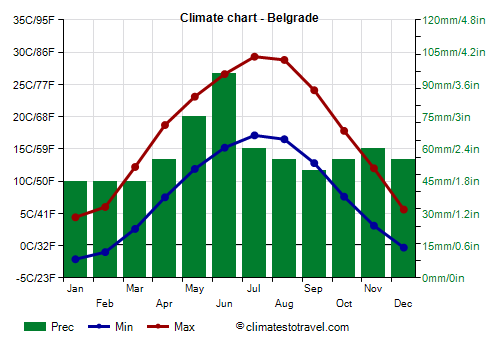
![]() Climate chart - Belgrade
Climate chart - Belgrade
In
Belgrade, the capital, precipitation amounts to 630 mm (24.8 in) per year. The wettest months are May and June, mainly due to afternoon thunderstorms, which can occur even in mid-summer, but in this season they become less frequent.
The amount of
sunshine in Belgrade is good from May to September, while it's poor or mediocre from November to January, when gray skies predominate.

Hills and mountains
While the north of Serbia is flat, in the
center-south we also find hilly and mountainous areas. However, the largest cities (
Kragujevac,
Niš) are located at a low altitude, in valleys surrounded by hills, and have a climate similar to that of Belgrade.
In the southwest, in the district of
Zlatibor, there are mountains belonging to the
Dinaric Alps, which reach about 1,500 meters (4,900 feet), while in the east, on the border with Bulgaria, we find Mount Midžor, 2,169 meters (7,116 feet) high, which belongs to the
Balkan Mountains (Stara planina) and is the highest peak of Serbia (excluding Kosovo).
Sjenica
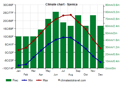
![]() Climate chart - Sjenica
Climate chart - Sjenica
In
Sjenica, located at 1,000 meters (3,350 feet), in the Zlatibor District, the average temperature ranges from -3 °C (26.5 °F) in January to 17 °C (62.5 °F) in July and August.
East of Sjenica, we find the ski resort of
Kopaonik.
Kosovo
In the south,
Kosovo (which is still unclear whether it will become an autonomous region or an independent state) is occupied by hills and mountains. Here, the lower latitude is offset by the higher altitude, so much so that the temperature can be even lower than in Serbia.
Priština
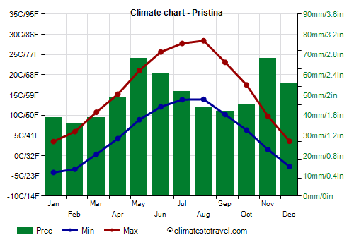
![]() Climate chart - Pristina
Climate chart - Pristina
In
Priština, located at 600 meters (2,000 feet) above sea level, the monthly average temperature ranges from around 0 °C (32 °F) in January to around 21 °C (70 °F) in July and August; nights remain cool even in summer.
Precipitation amounts to 600 mm (23.5 in) a year, so it is not abundant.
In areas located at higher altitudes, the climate is much colder, with freezing and snowy winters and cool summers.
In Kosovo, the highest
mountains are found. In the southwest, on the border with Montenegro and Albania, we find the group of the Prokletije (or Albanian Alps), which are part of the Dinaric Alps, and whose highest peak, at least in Kosovo, is Gjeravica, 2,656 meters (8,714 feet) high.
In the extreme south, on the border with Macedonia, we find the Šar Mountains (Šar-planina), whose highest peak, Great Rudoka, reaches 2,658 meters (8,720 feet), however, the most famous is Mount Ljuboten, 2,498 mt (8,196 ft) high, being separated from the others and recognizable both by Priština and by Skopje, the capital of Macedonia.
When to go
The best time to visit Serbia and Kosovo is from
May to September.
In May and June, afternoon thunderstorms are possible, and less frequently also in July and August, when in return there can be hot days.
In general, nights are cool, except during the most intense heat waves.
Those who don't like the heat can avoid July and August.
Therefore, the month of September, usually sunny and pleasantly warm, may be interesting.
What to pack
In
winter: bring warm clothes, such as a sweater or fleece, a down jacket, a hat, gloves and a scarf, a raincoat or umbrella.
In
summer: bring light clothes, T-shirts and shorts, but also long pants, a light jacket and a sweatshirt for the evening; a raincoat or umbrella.
Back to topSee also the
temperatures month by month