Select units of measurement for the temperature and rainfall tables (metric or imperial).
Average weather, temperature, rainfall, sunshine
The climate in Chad is
desert in the north,
semi-desert in the center, and
tropical with a wet season in the south.
In fact, the summer rains, which are brought by the
African monsoon, affect only the center-south of the country, and in a progressively more substantial manner as you proceed towards the south.
As a result, the
rainfall is lower than 50 millimeters (2 inches) per year in the north, it reaches 200 mm (8 in) in the center, and exceeds 1,000 mm (40 in) in the south. The rains occur from May to early October, although in the far south, some showers and thunderstorms occur as early as in April. Winter is dry everywhere.
The climate in detail
The north
In the
north, in the Sahara desert, winter is sunny and pleasantly warm during the day. In the Ennedi plateau, which lies in the north-east, temperatures are a bit lower, and even lower in the Tibesti Range, where we find a lunar landscape, and also the highest point of the country, Emi Koussi, 3,445 meters (11,300 feet) high. Every now and then, at night, the temperature can approach freezing (0 °C or 32 °F) at lower altitudes, while this happens quite often in the mountains. By contrast, during the day, the temperature can reach 30 °C (86 °F) even in winter, at least at low altitudes.
The rest of the year in the desert area is really hot, with highs around or above 40 °C (104 °F) from April to September; the highest recorded temperatures are about 50 °C (122 °F).
Throughout the year, the wind can raise sand storms across the desert area.
Faya-Largeau

In
Faya-Largeau, highs in January are around 27 °C (80.5 °F) and lows around 14 °C (57 °F). The hottest months, albeit slightly, are May and June, while later, in July and August, the area is reached by southern currents, the extreme offshoot of the monsoon, which are almost never able to bring some rainfall, but prevent a further increase in temperature.
The rains here are very rare: in July 2010, a strong thunderstorm hit Faya-Largeau, such as had not been seen in living memory.
In the desert area, the sun regularly shines throughout the year, in fact, with around 3,800 hours of sunshine per year, it is one of the sunniest areas in the world.

In the mountainous area of the
Tibesti, it's hot during the day, but nights can be cool even in summer. In the Tibesti Massif, the rainfall is slightly higher than in the surrounding area, though it's still at desert levels, in fact, it slightly exceeds 100 mm (4 in) per year. However, in this area, there are also fresh water springs (oases) as well as salt lakes.
The center
Continuing south, the influence of southern air masses becomes more remarkable in summer, when there is a decrease in temperature as well as an increase in cloudiness and humidity.
Lake Chad
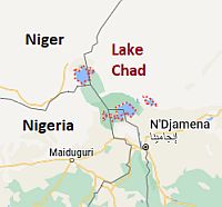 Lake Chad, where is located
In the area of
Lake Chad, from 200 to 300 mm (8 to 12 in) of rain fall per year. Lake Chad is a shallow lake, which has almost halved over the past 50 years, however, its size varies between the seasons and from year to year according to rainfall. It is not necessarily going to disappear, but its future depends on both the possible changes of the monsoon rains due to global warming. Furthermore, the tributaries of the lake are exploited by man to irrigate the fields and to bring water to the main cities.
N'Djamena

Continuing south, the rains become even more abundant. In the capital,
Ndjamena, to the south of the lake, rainfall amounts to 510 mm (20 in) per year, with the first rains in May, a maximum in July and August, and the last rains in early October.
Here, we are close enough to the Equator (12 degrees north latitude) to have high temperatures even in winter, around 30 °C (86 °F) during the day, and sometimes even above, although the air is dry and nights are cool. This is still the least hot period of the year, in fact, by February the temperature starts to rise, reaching a peak between April and May, when it often exceeds 40 °C (104 °F).
In summer, the monsoon gradually lowers the temperature again, down to 32 °C (90 °F) in August, although high humidity makes the heat sultry and therefore less tolerable than in winter.
After the monsoon, there is time for a new increase in the heat, which returns to be intense in October and November.
In N'Djamena, the sun shines regularly in the long dry season, while in the rainy season, the hours of sunshine decrease a little; the least sunny month is August. The total is 3,200 hours.
The south
Further south, we enter the area of the
savannah, where the landscape becomes definitely green during the rainy season. Floods are frequent, especially after the most intense downpours and in the years when the rains are more abundant. The
Zakouma National Park is located in the south-east, in an area where precipitation is between 800 and 900 mm (31 and 35 in) per year, and it's open only in the dry season, from December 1st to May 31th.
Moundou

In the far south, annual rainfall even exceeds 1,000 mm (40 in), as happens in
Moundou, where it amounts to 1,100 mm (43 in), with the first showers occurring already in April, and with more than 200 mm (8 in) of rain per month from July to September.
Although we are 400 meters (1,300 feet) above sea level, here, it's definitely hot even in December and January, with highs around 35 °C (95 °F), but fortunately, the temperatures at night drop a lot, to around 16/17 °C (61/63 °F). The hottest month is March, when highs are normally around 40 °C (104 °F). In summer, the monsoon lowers the temperature to around 30/31 °C (86/88 °F), but the heat becomes stifling.
In the south, the amount of sunshine in the dry season decreases more than in the rest of the country and for a longer period, in fact, the sunshine hours drop to 6/7 per day from June to September. The annual total is approximately 2,800 hours.

In
Sarh, the climate is similar to that of Moundou.
When to go
The best time to visit Chad is
winter, and in particular the months of December and January: the sky is clear, even though sometimes the north-east wind, the
Harmattan, can raise dust, creating a typical haze. During the day, it is very hot in the south, but nights are generally cool, while in the north, it can get cold at night, while the temperature becomes pleasant during the day.
Already in February, the temperature rises significantly in the south, approaching 40 °C (104 °F).
What to pack
In
winter: during the day, bring long, light and loose-fitting clothing of natural fabric (cotton or linen), especially in the south, where it is hot even in winter; a desert turban for the wind-borne sand and dust, sunglasses (even graduated instead of contact lenses), a jacket and a sweater for the evening, and desert boots or sandals. For the Tibesti and for nights outdoors in the desert, warm clothes, a warm jacket, gloves, and a hat.
In
summer: for the desert, bring loose-fitting, light-colored clothing, light and long shirts and pants, a wide-brimmed hat, a light scarf, sunglasses, comfortable and breathable shoes, and a desert turban. A sleeping bag and a sweater for overnight stays outdoors. For the Tibesti, at high altitudes, a jacket and a sweater. For N'Djamena and the south, tropics-friendly and light clothing, an umbrella or a light raincoat for the rain showers, and a light sweatshirt.
It's better for women to avoid shorts and miniskirts.
Climate data - Chad
| Abéché (545 meters) |
|---|
|
| Jan | Feb | Mar | Apr | May | Jun | Jul | Aug | Sep | Oct | Nov | Dec |
|---|
| Min temp. | 17 | 19 | 24 | 26 | 27 | 26 | 24 | 21 | 22 | 24 | 21 | 17 |
|---|
| Max temp. | 33 | 36 | 39 | 40 | 41 | 39 | 35 | 32 | 35 | 38 | 36 | 34 |
|---|
| Precip. | 0 | 0 | 0 | 5 | 10 | 35 | 100 | 165 | 55 | 5 | 0 | 0 |
|---|
| Prec. days | 0 | 0 | 1 | 2 | 4 | 6 | 12 | 14 | 7 | 2 | 1 | 0 |
|---|
|
|
| Sun hours | 10 | 10 | 10 | 10 | 10 | 10 | 8 | 7 | 9 | 10 | 10 | 10 |
|---|
|
| Faya Largeau (235 meters) |
|---|
|
| Jan | Feb | Mar | Apr | May | Jun | Jul | Aug | Sep | Oct | Nov | Dec |
|---|
| Min temp. | 14 | 17 | 21 | 24 | 27 | 29 | 28 | 27 | 28 | 25 | 19 | 15 |
|---|
| Max temp. | 27 | 30 | 36 | 40 | 43 | 44 | 43 | 41 | 42 | 37 | 33 | 28 |
|---|
| Precip. | 0 | 0 | 0 | 0 | 0 | 0 | 5 | 10 | 0 | 0 | 0 | 0 |
|---|
| Prec. days | 0 | 0 | 0 | 0 | 0 | 0 | 1 | 1 | 0 | 0 | 0 | 0 |
|---|
|
|
| Sun hours | 10 | 10 | 10 | 10 | 11 | 11 | 11 | 10 | 10 | 10 | 10 | 10 |
|---|
|
| Moundou (430 meters) |
|---|
|
| Jan | Feb | Mar | Apr | May | Jun | Jul | Aug | Sep | Oct | Nov | Dec |
|---|
| Min temp. | 17 | 20 | 24 | 26 | 24 | 23 | 22 | 22 | 22 | 22 | 19 | 16 |
|---|
| Max temp. | 34 | 37 | 39 | 39 | 35 | 32 | 31 | 30 | 31 | 33 | 35 | 34 |
|---|
| Precip. | 0 | 0 | 5 | 40 | 90 | 150 | 260 | 285 | 200 | 55 | 0 | 0 |
|---|
| Prec. days | 0 | 1 | 2 | 5 | 9 | 12 | 15 | 19 | 13 | 7 | 2 | 0 |
|---|
| Humidity | 21% | 20% | 23% | 39% | 57% | 70% | 75% | 78% | 76% | 65% | 40% | 27% |
|---|
| Day length | 12 | 12 | 12 | 12 | 12 | 13 | 13 | 12 | 12 | 12 | 12 | 12 |
|---|
| Sun hours | 9 | 9 | 8 | 8 | 8 | 7 | 6 | 6 | 6 | 8 | 9 | 9 |
|---|
|
| Ndjamena (300 meters) |
|---|
|
| Jan | Feb | Mar | Apr | May | Jun | Jul | Aug | Sep | Oct | Nov | Dec |
|---|
| Min temp. | 15 | 18 | 23 | 26 | 27 | 26 | 24 | 23 | 23 | 23 | 19 | 15 |
|---|
| Max temp. | 33 | 36 | 40 | 42 | 41 | 38 | 34 | 32 | 34 | 37 | 37 | 34 |
|---|
| Precip. | 0 | 0 | 0 | 10 | 25 | 50 | 145 | 175 | 85 | 20 | 0 | 0 |
|---|
| Prec. days | 0 | 0 | 1 | 3 | 6 | 9 | 13 | 15 | 9 | 3 | 1 | 0 |
|---|
| Humidity | 23% | 19% | 17% | 24% | 40% | 55% | 72% | 82% | 75% | 51% | 26% | 25% |
|---|
| Day length | 12 | 12 | 12 | 12 | 13 | 13 | 13 | 12 | 12 | 12 | 12 | 11 |
|---|
| Sun hours | 10 | 10 | 9 | 9 | 9 | 9 | 7 | 6 | 8 | 9 | 10 | 10 |
|---|
|
| Sarh (360 meters) |
|---|
|
| Jan | Feb | Mar | Apr | May | Jun | Jul | Aug | Sep | Oct | Nov | Dec |
|---|
| Min temp. | 17 | 21 | 24 | 26 | 24 | 23 | 22 | 22 | 22 | 22 | 20 | 17 |
|---|
| Max temp. | 36 | 39 | 40 | 39 | 36 | 33 | 31 | 31 | 32 | 34 | 36 | 36 |
|---|
| Precip. | 0 | 0 | 10 | 25 | 125 | 180 | 275 | 260 | 190 | 80 | 15 | 0 |
|---|
| Prec. days | 0 | 0 | 1 | 3 | 8 | 8 | 13 | 15 | 12 | 6 | 1 | 0 |
|---|
| Humidity | 26% | 23% | 30% | 43% | 57% | 69% | 78% | 81% | 79% | 73% | 54% | 36% |
|---|
| Day length | 12 | 12 | 12 | 12 | 13 | 13 | 13 | 12 | 12 | 12 | 12 | 12 |
|---|
| Sun hours | 9 | 9 | 8 | 8 | 8 | 7 | 6 | 6 | 6 | 8 | 9 | 9 |
|---|
|
See also the
temperatures month by month