Select units of measurement for the temperature and rainfall tables (metric or imperial).
Average weather, temperature, rainfall, sunshine
The climate of Egypt, a country in north-eastern Africa, is characterized by the scarcity of rainfall and the abundance of sunshine. In fact, in much of the country, occupied by the eastern part of the Sahara, the climate is
desert. Only on the northern coast, overlooking the Mediterranean, there is a certain amount of rain in winter.
As for the
temperatures, they are milder on the north coast, while they gradually get warmer as you go south.
Along the
Red Sea coast, temperatures are higher than on the Mediterranean coast but lower than in inland areas. However, summer is very hot.
The only mountainous areas, where it can get cold in winter, are located in the east, on the
Sinai peninsula.
The wind in Egypt is often absent or weak, in the form of breezes along the coasts, but sometimes, especially in spring (April to June), the
Khamsin can blow for a few days: it is a hot, dry wind able to raise dust or cause sand storms and to make travel and communication difficult.
The climate in detail
The north coast
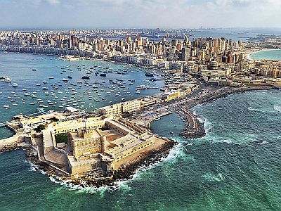
On the northern coast (see Alexandria,
Marsa Matrouh,
Port Said), the climate can be defined as Mediterranean, even though the winter is very mild, and the rains are very scarce.
Alexandria

In
Alexandria, Egypt's second city, there is a spring-like
winter: highs are around 18/20 °C (64/68 °F) and lows around 10 °C (50 °F), though this is the only period of the year when weak or moderate rains occur.
Summer is long, muggy and sunny, with highs around 30 °C (86 °F), but tempered by sea breezes. The humidity is high especially in the delta of the Nile River.
On the northern coast,
rainfall follows the Mediterranean pattern, but it is scarce and concentrated in winter, since this is the only period when depressions can affect this area. In Alexandria, rainfall amounts to only 230 mm (9 inches) per year (but in other cities on the north coast, it barely reaches 100 millimeters or 4 inches).
The temperature of the Mediterranean Sea is warm from July to October, but all in all, it is warm enough for swimming also in June.
Cairo
 Cairo
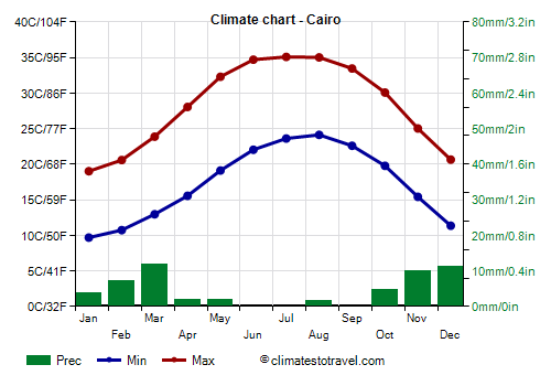
Cairo, the capital, is located about 180 kilometers (110 miles) away from the sea, but it's at the edge of the huge Nile River Delta, so its climate is halfway between the Mediterranean and the desert one. The winter is similar to that of the north coast: highs are around 19/21 °C (66/70 °F) between December and February, although cold and cloudy days may sometimes occur, when northern currents prevail.
The summer temperatures are lower than in the desert area but higher than on the coast: highs are around 35 °C (95 °F) in July and August, but moisture is quite high, so the heat can be stifling. Summer is long: the maximum temperatures exceed 30 °C (86 °F) from May to mid-October. Within the city, the unpleasant sensation of heat is increased by the so-called "urban heat island effect" which occurs in big cities, and also by pollution.
The rainfall in Cairo is poor, since it amounts to only 55 mm (2.1 in) per year, and it's absent in the long summer: as regards to the rainfall, we are already in the desert.
The sun frequently shines in all seasons, and it almost always shines in the long period that goes from spring to autumn.

Inland areas
In the
interior, the climate is desert, with virtually no rain; the temperatures increase gradually as you head south.
The diurnal temperature range is remarkable because of both clear skies and low humidity. The Egyptian central-southern desert is one of the sunniest places on Earth: clear skies are a permanent feature in all seasons.
Luxor
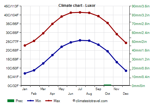
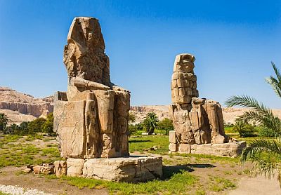
Winters are mild and sunny, but nights are cool to cold, ranging from 7/8 °C (45/46 °F) in the central area (see
Luxor) to 10/11 °C in the southern area (see
Aswan), though the temperature in the coldest nights can approach freezing (0 °C or 32 °F). The winter days are pleasantly mild or warm, about 23/24 °C (73/75 °F) on average.
In inland areas, summers are scorchingly hot, with highs ranging from 36/37 °C (97/99 °F) in the center-north to 41/42 °C (106/108 °F) in the south, and during this season, the sun hits hard. In the hottest days, the temperature in the south can reach as high as 48/50 °C (118/122 °F).
Red Sea coasts
To the east, in the Gulf of Suez (see
El Tor), and on the
coast of the Red Sea (see
Hurghada,
Marsa Alam), the climate is desert, albeit slightly tempered by the sea.
The rainfall is very scarce or totally absent as in the interior, but the temperature range is lower and the humidity is generally higher.
The days in summer are very hot, with maximum temperatures around 35 °C (95 °F) or more, with some days a little less hot but more sultry and others torrid, that is, very hot and with lower humidity.
During winter, the temperature on the coast is very mild: in the northern part, highs hover around 21/22 °C (70/72 °F) and lows remain around 10/12 °C (50/54 °F), while the southern part is slightly warmer.
Sharm el Sheikh
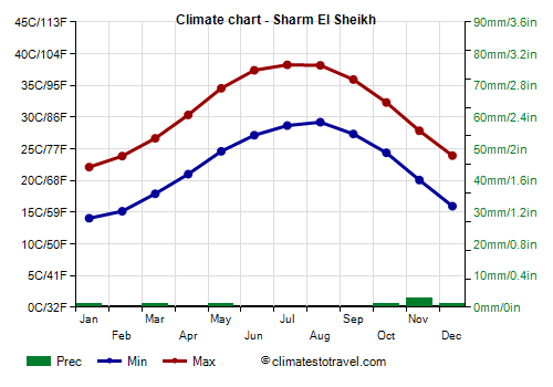
On the coast to the east of Sinai (see
Sharm el Sheikh), where the prevailing wind in summer comes from the desert, the heat is more intense but moisture is generally lower.
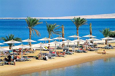
The temperature of the Red Sea is very high in summer, while from January to March, in the north-central part, it is a bit cool for swimming, but all in all, it's not impossible.
In the south-central part of the Red Sea coast (see Marsa Alam), the sea temperature is a bit higher in winter, since it doesn't go below 22.5 °C (72.5 °F) in February.
Sinai
In the highlands of
Sinai, the climate is cooled by altitude, and temperatures are lower especially at night: during winter, there can be some frosts at night, and even some snowfalls. During summer, the heat is intense during the day, while nights remain cool.
In
Nekhel (or El Nakhl), located at an altitude of 400 meters (1,300 ft) in central Sinai, in winter, the night temperature can drop slightly below freezing. In December 2005 it dropped to -8 °C (17.5 °F). From April to September, the temperature can reach 40/42 °C (104/108 °F) when the south wind blows.
The tallest mountain in Egypt is Mount Catherine (Gabal Katrîne), 2,629 meters (8,625 feet) high, located in the southern part of Sinai.
When to go
If you want to visit the
archaeological sites of Egypt, such as the Great Pyramids of El Giza, the best time is winter (
November to February), when the weather is normally mild and sunny. The temperature range can be high, especially in the south, so much so that it can be warm during the day but even cold at night.
The absolute best months are probably November in the north (Cairo, El Giza) and December in the center-south (Luxor, Aswan).
In spring, the temperatures are higher (in the south, the days in April are already scorching), but nights are cool; sometimes, however, the
Khamsin blows.
In summer, on the northern coast and down to El Cairo and Giza, the heat is sweltering, while further south, the heat is intense but dry; a relentless sun reigns everywhere. During this period, it can be unpleasant to visit the archaeological sites for those who don't like the heat, though, on the positive side, in this period there's a lower number of tourists.
If you want to go on a
beach holiday, it's necessary to distinguish between the coast of the Mediterranean and that of the Red Sea.
On the
Mediterranean Coast, the long summer, from mid-May to mid-October, is fine, although, as previously mentioned, the sea in May is still cool.
On the
Red Sea coast, summer is too hot, while winter is a bit cool, so the best periods are spring and autumn.
In Sharm el Sheikh, the best times are the month of April, and from mid-October to mid-November. As previously mentioned, because of the thermal inertia of the sea, the sea is warmer in the latter period. During winter, the sun often shines but the air temperature, though pleasant, is not always high enough for swimming and sunbathing, while in summer, the weather is often too hot.
What to pack
In
winter: in Cairo, bring spring/autumn clothes, a jacket and a sweater, warm clothing for hotels and houses which could not be heated; in Alexandria and the Mediterranean coast, you can add a raincoat or umbrella.
In the desert, bring light clothing, but also a sweater and a warm jacket for the evening, and a scarf for the sand.
On the Red Sea Coast, bring light clothes for the day, a sweater and a light jacket for the evening. In Sinai, a warm jacket and hiking boots. For boat trips, a wind jacket.
In
summer: on the Mediterranean Coast and in Cairo, bring summer clothes; add a light sweatshirt for the evening on the coast.
In the desert, bring loose-fitting, light-colored clothing, light and long shirts and pants of natural fibers (cotton, linen), a wide-brimmed hat, a light scarf, sunglasses (even graduated instead of contact lenses), comfortable and breathable shoes; a sweatshirt for the night, a sleeping bag to sleep outdoors; desert boots or sandals. It's best for women to avoid shorts and miniskirts in rural and non-tourist areas.
On the Red Sea Coast, bring lightweight clothes. When going to the reef, you can bring snorkeling equipment, including water shoes or rubber-soled shoes.
Climate data - Egypt
| Abu Simbel |
|---|
|
| Jan | Feb | Mar | Apr | May | Jun | Jul | Aug | Sep | Oct | Nov | Dec |
|---|
| Min temp. | 9 | 12 | 15 | 20 | 23 | 26 | 26 | 27 | 26 | 22 | 17 | 12 |
|---|
| Max temp. | 23 | 26 | 31 | 35 | 39 | 41 | 42 | 42 | 40 | 36 | 30 | 25 |
|---|
| Precip. | 0 | 0 | 0 | 0 | 0 | 0 | 0 | 0 | 0 | 0 | 0 | 0 |
|---|
| Prec. days | 0 | 0 | 0 | 0 | 0 | 0 | 0 | 0 | 0 | 0 | 0 | 0 |
|---|
|
|
|
|
| Alexandria |
|---|
|
| Jan | Feb | Mar | Apr | May | Jun | Jul | Aug | Sep | Oct | Nov | Dec |
|---|
| Min temp. | 9 | 10 | 12 | 14 | 18 | 21 | 24 | 24 | 22 | 19 | 15 | 11 |
|---|
| Max temp. | 18 | 19 | 21 | 24 | 27 | 29 | 31 | 31 | 30 | 28 | 24 | 20 |
|---|
| Precip. | 70 | 35 | 20 | 0 | 0 | 0 | 0 | 0 | 0 | 15 | 35 | 55 |
|---|
| Prec. days | 9 | 6 | 3 | 1 | 1 | 0 | 0 | 0 | 0 | 2 | 4 | 7 |
|---|
| Humidity | 70% | 67% | 65% | 63% | 64% | 67% | 69% | 69% | 65% | 65% | 68% | 70% |
|---|
| Day length | 10 | 11 | 12 | 13 | 14 | 14 | 14 | 13 | 12 | 11 | 11 | 10 |
|---|
| Sun hours | 6 | 8 | 8 | 9 | 10 | 12 | 12 | 11 | 10 | 9 | 8 | 6 |
|---|
| Sea temp | 18 | 17 | 17 | 18 | 20 | 23 | 26 | 27 | 27 | 25 | 22 | 20 |
|---|
| Aswan |
|---|
|
| Jan | Feb | Mar | Apr | May | Jun | Jul | Aug | Sep | Oct | Nov | Dec |
|---|
| Min temp. | 10 | 11 | 15 | 20 | 25 | 27 | 28 | 28 | 26 | 22 | 16 | 11 |
|---|
| Max temp. | 23 | 26 | 30 | 35 | 40 | 42 | 42 | 42 | 40 | 36 | 30 | 24 |
|---|
| Precip. | 0 | 0 | 0 | 5 | 0 | 0 | 0 | 0 | 0 | 0 | 0 | 0 |
|---|
| Prec. days | 0 | 0 | 0 | 0 | 0 | 0 | 0 | 0 | 0 | 0 | 0 | 0 |
|---|
| Humidity | 39% | 30% | 23% | 18% | 16% | 16% | 18% | 20% | 22% | 27% | 35% | 40% |
|---|
| Day length | 11 | 11 | 12 | 13 | 13 | 14 | 13 | 13 | 12 | 12 | 11 | 11 |
|---|
| Sun hours | 10 | 10 | 10 | 11 | 11 | 12 | 12 | 12 | 10 | 10 | 10 | 9 |
|---|
|
| Asyut (225 meters) |
|---|
|
| Jan | Feb | Mar | Apr | May | Jun | Jul | Aug | Sep | Oct | Nov | Dec |
|---|
| Min temp. | 6 | 7 | 11 | 15 | 20 | 22 | 23 | 23 | 21 | 18 | 12 | 8 |
|---|
| Max temp. | 20 | 22 | 26 | 31 | 35 | 37 | 38 | 38 | 35 | 32 | 26 | 22 |
|---|
| Precip. | 0 | 0 | 0 | 0 | 0 | 0 | 0 | 0 | 0 | 0 | 0 | 0 |
|---|
| Prec. days | 0 | 0 | 0 | 0 | 0 | 0 | 0 | 0 | 0 | 0 | 0 | 0 |
|---|
| Humidity | 54% | 45% | 38% | 31% | 29% | 31% | 33% | 35% | 40% | 45% | 52% | 56% |
|---|
| Day length | 11 | 11 | 12 | 13 | 14 | 14 | 14 | 13 | 12 | 12 | 11 | 10 |
|---|
|
|
| Bahariya |
|---|
|
| Jan | Feb | Mar | Apr | May | Jun | Jul | Aug | Sep | Oct | Nov | Dec |
|---|
| Min temp. | 6 | 7 | 11 | 14 | 18 | 21 | 22 | 23 | 21 | 17 | 12 | 8 |
|---|
| Max temp. | 21 | 23 | 27 | 31 | 35 | 38 | 39 | 39 | 36 | 32 | 27 | 22 |
|---|
| Precip. | 0 | 0 | 0 | 0 | 0 | 0 | 0 | 0 | 0 | 0 | 0 | 0 |
|---|
| Prec. days | 0 | 0 | 0 | 0 | 0 | 0 | 0 | 0 | 0 | 0 | 0 | 0 |
|---|
|
|
|
|
| Cairo |
|---|
|
| Jan | Feb | Mar | Apr | May | Jun | Jul | Aug | Sep | Oct | Nov | Dec |
|---|
| Min temp. | 10 | 11 | 13 | 16 | 19 | 22 | 24 | 24 | 23 | 20 | 15 | 11 |
|---|
| Max temp. | 19 | 21 | 24 | 28 | 32 | 35 | 35 | 35 | 33 | 30 | 25 | 21 |
|---|
| Precip. | 5 | 5 | 10 | 0 | 0 | 0 | 0 | 0 | 0 | 5 | 10 | 10 |
|---|
| Prec. days | 3 | 2 | 1 | 3 | 1 | 0 | 0 | 0 | 0 | 1 | 1 | 2 |
|---|
| Humidity | 59% | 55% | 52% | 46% | 44% | 48% | 55% | 57% | 56% | 58% | 60% | 61% |
|---|
| Day length | 10 | 11 | 12 | 13 | 14 | 14 | 14 | 13 | 12 | 11 | 11 | 10 |
|---|
| Sun hours | 7 | 8 | 9 | 10 | 10 | 12 | 12 | 11 | 10 | 9 | 8 | 6 |
|---|
|
| Dakhla |
|---|
|
| Jan | Feb | Mar | Apr | May | Jun | Jul | Aug | Sep | Oct | Nov | Dec |
|---|
| Min temp. | 6 | 7 | 8 | 16 | 21 | 22 | 23 | 25 | 23 | 18 | 12 | 8 |
|---|
| Max temp. | 22 | 25 | 26 | 36 | 39 | 39 | 42 | 42 | 40 | 35 | 29 | 24 |
|---|
| Precip. | 0 | 0 | 0 | 0 | 0 | 0 | 0 | 0 | 0 | 0 | 0 | 0 |
|---|
| Prec. days | 0 | 0 | 0 | 0 | 0 | 0 | 0 | 0 | 0 | 0 | 0 | 0 |
|---|
|
|
| Sun hours | 10 | 10 | 10 | 10 | 12 | 12 | 12 | 12 | 11 | 11 | 10 | 9 |
|---|
|
| El Arish |
|---|
|
| Jan | Feb | Mar | Apr | May | Jun | Jul | Aug | Sep | Oct | Nov | Dec |
|---|
| Min temp. | 7 | 8 | 10 | 12 | 16 | 19 | 21 | 22 | 20 | 17 | 13 | 9 |
|---|
| Max temp. | 19 | 20 | 22 | 26 | 29 | 31 | 33 | 33 | 32 | 29 | 25 | 21 |
|---|
| Precip. | 25 | 15 | 15 | 5 | 5 | 0 | 0 | 0 | 0 | 10 | 10 | 15 |
|---|
| Prec. days | 4 | 2 | 1 | 3 | 1 | 0 | 0 | 0 | 0 | 1 | 1 | 3 |
|---|
| Humidity | 69% | 68% | 66% | 64% | 65% | 67% | 69% | 70% | 68% | 69% | 69% | 68% |
|---|
| Day length | 10 | 11 | 12 | 13 | 14 | 14 | 14 | 13 | 12 | 11 | 11 | 10 |
|---|
|
| Sea temp | 18 | 17 | 17 | 18 | 20 | 23 | 26 | 27 | 27 | 25 | 22 | 20 |
|---|
| El Tor |
|---|
|
| Jan | Feb | Mar | Apr | May | Jun | Jul | Aug | Sep | Oct | Nov | Dec |
|---|
| Min temp. | 10 | 12 | 15 | 18 | 22 | 24 | 25 | 26 | 25 | 21 | 16 | 12 |
|---|
| Max temp. | 21 | 22 | 25 | 28 | 32 | 33 | 35 | 35 | 32 | 30 | 26 | 23 |
|---|
| Precip. | 0 | 0 | 0 | 5 | 0 | 0 | 0 | 0 | 5 | 0 | 0 | 0 |
|---|
| Prec. days | 0 | 0 | 0 | 0 | 0 | 0 | 0 | 0 | 0 | 0 | 0 | 0 |
|---|
| Humidity | 52% | 50% | 50% | 51% | 54% | 57% | 59% | 60% | 62% | 61% | 55% | 52% |
|---|
| Day length | 11 | 11 | 12 | 13 | 14 | 14 | 14 | 13 | 12 | 12 | 11 | 10 |
|---|
|
| Sea temp | 21 | 21 | 21 | 22 | 24 | 26 | 27 | 28 | 27 | 26 | 25 | 23 |
|---|
| Hurghada |
|---|
|
| Jan | Feb | Mar | Apr | May | Jun | Jul | Aug | Sep | Oct | Nov | Dec |
|---|
| Min temp. | 11 | 12 | 15 | 19 | 23 | 26 | 28 | 28 | 26 | 22 | 18 | 13 |
|---|
| Max temp. | 22 | 24 | 26 | 30 | 34 | 36 | 37 | 38 | 35 | 32 | 28 | 24 |
|---|
| Precip. | 0 | 0 | 5 | 0 | 5 | 0 | 0 | 0 | 5 | 5 | 0 | 5 |
|---|
| Prec. days | 0 | 0 | 0 | 0 | 0 | 0 | 0 | 0 | 0 | 0 | 0 | 0 |
|---|
| Humidity | 48% | 44% | 42% | 36% | 33% | 32% | 34% | 36% | 40% | 47% | 50% | 50% |
|---|
| Day length | 11 | 11 | 12 | 13 | 14 | 14 | 14 | 13 | 12 | 12 | 11 | 10 |
|---|
| Sun hours | 9 | 10 | 9 | 10 | 10 | 12 | 11 | 10 | 10 | 9 | 9 | 8 |
|---|
| Sea temp | 22 | 21 | 21 | 22 | 24 | 26 | 27 | 28 | 27 | 26 | 25 | 23 |
|---|
| Luxor |
|---|
|
| Jan | Feb | Mar | Apr | May | Jun | Jul | Aug | Sep | Oct | Nov | Dec |
|---|
| Min temp. | 7 | 9 | 13 | 17 | 22 | 25 | 26 | 25 | 23 | 19 | 13 | 8 |
|---|
| Max temp. | 23 | 25 | 30 | 35 | 39 | 41 | 41 | 41 | 39 | 35 | 29 | 24 |
|---|
| Precip. | 0 | 0 | 0 | 0 | 0 | 0 | 0 | 0 | 0 | 0 | 0 | 0 |
|---|
| Prec. days | 0 | 0 | 0 | 0 | 0 | 0 | 0 | 0 | 0 | 0 | 0 | 1 |
|---|
| Humidity | 53% | 44% | 36% | 29% | 26% | 27% | 30% | 31% | 35% | 40% | 49% | 54% |
|---|
| Day length | 11 | 11 | 12 | 13 | 13 | 14 | 14 | 13 | 12 | 12 | 11 | 11 |
|---|
| Sun hours | 7 | 8 | 9 | 10 | 10 | 12 | 12 | 11 | 10 | 9 | 8 | 6 |
|---|
|
| Marsa Alam |
|---|
|
| Jan | Feb | Mar | Apr | May | Jun | Jul | Aug | Sep | Oct | Nov | Dec |
|---|
| Min temp. | 13 | 14 | 16 | 20 | 23 | 25 | 26 | 26 | 25 | 22 | 18 | 15 |
|---|
| Max temp. | 23 | 24 | 27 | 30 | 32 | 35 | 35 | 35 | 34 | 32 | 27 | 25 |
|---|
| Precip. | 0 | 0 | 0 | 0 | 0 | 0 | 0 | 0 | 0 | 0 | 5 | 0 |
|---|
| Prec. days | 0 | 0 | 0 | 0 | 0 | 0 | 0 | 0 | 0 | 0 | 0 | 0 |
|---|
|
| Day length | 11 | 11 | 12 | 13 | 13 | 14 | 14 | 13 | 12 | 12 | 11 | 11 |
|---|
| Sun hours | 9 | 10 | 10 | 11 | 12 | 13 | 13 | 12 | 11 | 10 | 10 | 9 |
|---|
| Sea temp | 23 | 23 | 23 | 24 | 25 | 27 | 28 | 29 | 29 | 28 | 26 | 25 |
|---|
| Marsa Matruh |
|---|
|
| Jan | Feb | Mar | Apr | May | Jun | Jul | Aug | Sep | Oct | Nov | Dec |
|---|
| Min temp. | 9 | 10 | 11 | 13 | 16 | 20 | 22 | 23 | 21 | 18 | 15 | 11 |
|---|
| Max temp. | 18 | 19 | 21 | 23 | 26 | 28 | 30 | 31 | 30 | 27 | 24 | 20 |
|---|
| Precip. | 30 | 20 | 10 | 10 | 5 | 0 | 0 | 0 | 0 | 10 | 20 | 40 |
|---|
| Prec. days | 7 | 3 | 1 | 5 | 1 | 0 | 0 | 0 | 0 | 1 | 3 | 6 |
|---|
| Humidity | 68% | 65% | 65% | 64% | 67% | 70% | 72% | 72% | 67% | 65% | 66% | 67% |
|---|
| Day length | 10 | 11 | 12 | 13 | 14 | 14 | 14 | 13 | 12 | 11 | 10 | 10 |
|---|
| Sun hours | 6 | 8 | 8 | 9 | 10 | 12 | 12 | 11 | 10 | 9 | 7 | 6 |
|---|
| Sea temp | 18 | 17 | 17 | 18 | 20 | 23 | 26 | 27 | 27 | 25 | 23 | 20 |
|---|
| Minya |
|---|
|
| Jan | Feb | Mar | Apr | May | Jun | Jul | Aug | Sep | Oct | Nov | Dec |
|---|
| Min temp. | 6 | 7 | 10 | 13 | 18 | 21 | 22 | 22 | 21 | 17 | 12 | 7 |
|---|
| Max temp. | 20 | 22 | 26 | 31 | 35 | 37 | 37 | 37 | 35 | 31 | 26 | 21 |
|---|
| Precip. | 0 | 0 | 0 | 0 | 0 | 0 | 0 | 0 | 0 | 0 | 0 | 0 |
|---|
| Prec. days | 0 | 0 | 0 | 0 | 0 | 0 | 0 | 0 | 0 | 0 | 0 | 0 |
|---|
|
|
|
|
| Nekhel (400 meters) |
|---|
|
| Jan | Feb | Mar | Apr | May | Jun | Jul | Aug | Sep | Oct | Nov | Dec |
|---|
| Min temp. | 2 | 3 | 6 | 10 | 13 | 16 | 18 | 19 | 17 | 14 | 8 | 3 |
|---|
| Max temp. | 18 | 20 | 24 | 28 | 32 | 34 | 36 | 36 | 33 | 29 | 24 | 19 |
|---|
| Precip. | 5 | 10 | 5 | 5 | 0 | 0 | 0 | 0 | 0 | 0 | 5 | 5 |
|---|
|
|
|
|
|
| Port Said |
|---|
|
| Jan | Feb | Mar | Apr | May | Jun | Jul | Aug | Sep | Oct | Nov | Dec |
|---|
| Min temp. | 12 | 13 | 14 | 17 | 20 | 23 | 25 | 26 | 25 | 22 | 19 | 14 |
|---|
| Max temp. | 18 | 19 | 21 | 23 | 26 | 28 | 31 | 31 | 30 | 27 | 24 | 20 |
|---|
| Precip. | 20 | 10 | 10 | 5 | 5 | 0 | 0 | 0 | 5 | 10 | 5 | 15 |
|---|
| Prec. days | 2 | 1 | 0 | 2 | 0 | 0 | 0 | 0 | 0 | 1 | 1 | 2 |
|---|
| Humidity | 73% | 71% | 70% | 70% | 72% | 72% | 74% | 73% | 70% | 70% | 70% | 72% |
|---|
| Day length | 10 | 11 | 12 | 13 | 14 | 14 | 14 | 13 | 12 | 11 | 11 | 10 |
|---|
| Sun hours | 7 | 7 | 9 | 10 | 11 | 12 | 12 | 12 | 11 | 10 | 9 | 7 |
|---|
| Sea temp | 18 | 17 | 17 | 18 | 21 | 24 | 26 | 28 | 27 | 26 | 23 | 20 |
|---|
| Sharm El Sheikh |
|---|
|
| Jan | Feb | Mar | Apr | May | Jun | Jul | Aug | Sep | Oct | Nov | Dec |
|---|
| Min temp. | 14 | 15 | 18 | 21 | 25 | 27 | 29 | 29 | 27 | 24 | 20 | 16 |
|---|
| Max temp. | 22 | 24 | 27 | 30 | 35 | 37 | 38 | 38 | 36 | 32 | 28 | 24 |
|---|
| Precip. | 0 | 0 | 0 | 0 | 0 | 0 | 0 | 0 | 0 | 0 | 5 | 0 |
|---|
| Prec. days | 0 | 0 | 1 | 0 | 0 | 0 | 0 | 0 | 0 | 0 | 0 | 0 |
|---|
| Humidity | 43% | 41% | 38% | 33% | 30% | 29% | 33% | 35% | 40% | 44% | 44% | 43% |
|---|
| Day length | 11 | 11 | 12 | 13 | 14 | 14 | 14 | 13 | 12 | 12 | 11 | 10 |
|---|
| Sun hours | 8 | 9 | 10 | 10 | 11 | 13 | 13 | 12 | 11 | 10 | 9 | 8 |
|---|
| Sea temp | 22 | 21 | 21 | 23 | 24 | 26 | 27 | 28 | 28 | 27 | 25 | 24 |
|---|
| Siwa |
|---|
|
| Jan | Feb | Mar | Apr | May | Jun | Jul | Aug | Sep | Oct | Nov | Dec |
|---|
| Min temp. | 7 | 8 | 11 | 14 | 18 | 22 | 22 | 23 | 20 | 17 | 11 | 7 |
|---|
| Max temp. | 19 | 22 | 26 | 30 | 32 | 36 | 37 | 38 | 35 | 30 | 24 | 19 |
|---|
| Precip. | 0 | 0 | 0 | 0 | 0 | 0 | 0 | 0 | 0 | 0 | 0 | 0 |
|---|
| Prec. days | 0 | 0 | 0 | 0 | 0 | 0 | 0 | 0 | 0 | 0 | 0 | 0 |
|---|
|
|
| Sun hours | 7 | 9 | 9 | 10 | 10 | 11 | 11 | 12 | 11 | 9 | 9 | 8 |
|---|
|
See also the
temperatures month by month