Select units of measurement for the temperature and rainfall tables (metric or imperial).
Average weather, temperature, rainfall, sunshine
In Burkina Faso, the climate is
tropical, with a rainy season in the summer months due to the African monsoon, and a dry season in winter.
In the north, the rainy season is shorter and less intense, so the climate is
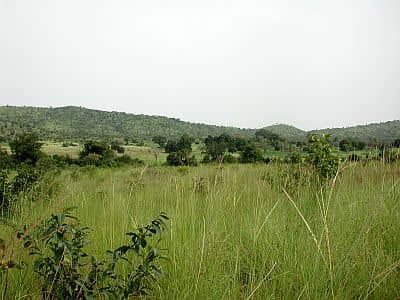
semi-arid. On the other hand, in the south, the rains last longer and are able to feed a lusher vegetation, in fact there are nature reserves, which have the flora and fauna of the
savannah.
The
temperatures in Burkina Faso are high throughout the year.
The climate in detail
The seasons
In
winter, the air is dry because of the prevalence of the northeast winds, and highs are around 30/32 °C (86/90 °F) in the north and 32/33 °C (90/91 °F) in the south, even in the coolest months, ie December and January, but sometimes they can be higher. The prevailing wind, called
Harmattan, blows from the north-east and is able to lift dust, making the sky whitish, but it can also cause real sandstorms. Storms can also occur in spring because of the clash with moist air masses that come from the ocean and advance towards the interior.
Although the winter is normally warm, sometimes it can get a bit
cold at night. The cold records are around 6/7 °C (43/45 °F) in the north and 10 °C (50 °F) in the south.
Starting from
February, the temperature begins to rise, and the heat becomes scorching. In the south, the first
rains occur quite early, and are able to increase the humidity but also to hinder the increase of temperature; on the other hand, in the north and partly in the center,
the heat increases until April and May, when highs reach normally 40/42 °C (104/108 °F).
The highest recorded temperatures are impressive, especially in the north, where they are around 47/48 °C (117/118 °F), and has been recorded in April and May. In the south, the heat records are around 42/44 °C (108/111 °F), and has been set between February and April, and even in January in the extreme south, where the sun's rays in winter are stronger because of the proximity to the Equator.
In May and June, the first significant rains coming from the south may be preceded or accompanied by whirlwinds and tornadoes, which are caused by the clash with the preexistent dry air masses.
Between July and September, when the
monsoon manifests its greatest effects, the temperature drops everywhere, with highs about 28/32 °C (82/90 °F), but high humidity makes the heat uncomfortable. However, even in summer there can still be some scorching days, in the pauses between the rainy periods, especially in the north, where the monsoon is less intense and consistent.
In October and November, the heat starts to increase again with the
withdrawal of the monsoon, more in the north, where highs return to about 40 °C (104 °F), than in the south, where they remain around 35 °C (95 °F).
The center-north
The northern part of Burkina Faso belongs to the climate zone of the
Sahel, in fact, the northernmost region is called "Sahel Region", where less than 600 millimeters (23.5 iches) of rain fall per year.
Dori
In
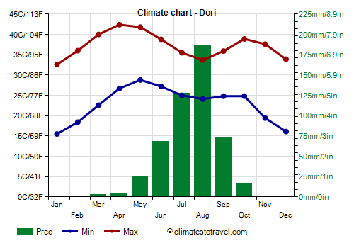
Dori, rainfall amounts to only 500 mm (20 in) per year, and it exceeds 50 mm (2 in) per month only from June to September, with a peak in August.
In Dori, temperatures are high all year round; the hottest periods, which are often scorching, are those that precede and follow the rainy season, that is, March-May and mid-September to November.
Ouagadougou
In the capital,
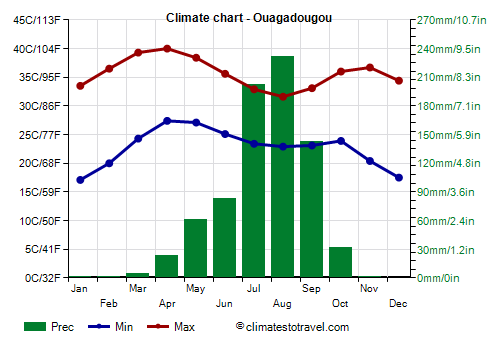
Ouagadougou, located in the center of the country, the rains amount to 785 mm (31 in) per year and are concentrated from May to early October, while in the rest of the year they are sporadic, especially in winter, when it hardly ever rains, as happens in the rest of the country.
In Ouagadougou it is hot all year round as well, but from April to October the temperatures are a bit lower than in the north, because it is more easily reached by humid air masses from the south, especially in the rainy season.
In Ouagadougou, the
sun shines all year round; however, in the rainy season, and in particular from July to September, the sunshine duration decreases a little. In the extreme south, where it rains more often, this decrease is more evident.
The south
In the south, the rainfall exceeds 1,000 mm (40 in) per year, and the rainy season is longer.
Bobo-Dioulasso
In
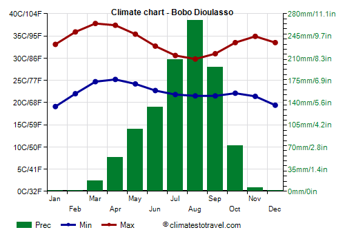
Bobo-Dioulasso, the second city of the country, precipitation amounts to 1,000 mm (40 in) per year.
In Bobo-Dioulasso, the scorching heat is rarer in the dry months, while from July to September, the maximum temperature does not go above 30-31 °C (86-88 °F) on average. So, paradoxically, the south is not as hot as the north.
In
Gaoua, rainfall amounts to 1,100 mm (43.5 in) per year.
The Karfiguela falls are located in the south, near Banfora, in the rainiest region of the country.
When to go
The best time to visit Burkina Faso is
winter, especially the months of December and January: the weather is good, it's hot but the air is dry. Sometimes at night it can be a bit cold, especially in the north, while during the day it can get hot everywhere, but especially in the south.
By February, the heat increases and becomes intense starting from the south, then spring is very hot everywhere.
Summer is rainy, and particularly intense showers can sometimes cause flooding.
All in all, even
November, which is a hot month, can be chosen because it is not so different from December and January, especially in the south.
What to pack
In
winter: bring light clothes for the day, long, loose-fitting and of natural fabric (cotton or linen), a desert turban for the wind-borne sand and dust, sunglasses (even graduated instead of contact lenses), a jacket and a sweater for the evening, desert boots or sandals.
In
summer: bring light, tropics-friendly clothes, a light sweatshirt, a light raincoat (or umbrella) for the rain showers.
Climate data - Burkina Faso
| Bobo Dioulasso (460 meters) |
|---|
|
| Jan | Feb | Mar | Apr | May | Jun | Jul | Aug | Sep | Oct | Nov | Dec |
|---|
| Min temp. | 19 | 22 | 25 | 25 | 24 | 23 | 22 | 22 | 22 | 22 | 21 | 19 |
|---|
| Max temp. | 33 | 36 | 38 | 37 | 35 | 33 | 31 | 30 | 31 | 34 | 35 | 34 |
|---|
| Precip. | 0 | 0 | 15 | 55 | 100 | 135 | 205 | 270 | 195 | 70 | 5 | 0 |
|---|
| Prec. days | 0 | 0 | 1 | 4 | 8 | 9 | 13 | 16 | 14 | 7 | 1 | 0 |
|---|
| Humidity | 21% | 20% | 29% | 48% | 62% | 71% | 79% | 83% | 80% | 69% | 41% | 26% |
|---|
| Day length | 12 | 12 | 12 | 12 | 13 | 13 | 13 | 12 | 12 | 12 | 12 | 12 |
|---|
| Sun hours | 9 | 9 | 8 | 8 | 8 | 8 | 7 | 6 | 7 | 9 | 9 | 9 |
|---|
|
| Bogandé (295 meters) |
|---|
|
| Jan | Feb | Mar | Apr | May | Jun | Jul | Aug | Sep | Oct | Nov | Dec |
|---|
| Min temp. | 17 | 20 | 24 | 28 | 28 | 26 | 24 | 23 | 23 | 24 | 20 | 17 |
|---|
| Max temp. | 32 | 36 | 39 | 40 | 39 | 36 | 33 | 31 | 33 | 36 | 36 | 34 |
|---|
| Precip. | 0 | 0 | 0 | 10 | 40 | 95 | 175 | 195 | 105 | 25 | 0 | 0 |
|---|
| Prec. days | 0 | 0 | 0 | 1 | 4 | 6 | 10 | 12 | 8 | 3 | 0 | 0 |
|---|
|
|
| Sun hours | 9 | 9 | 9 | 8 | 9 | 8 | 8 | 7 | 8 | 9 | 10 | 10 |
|---|
|
| Boromo (270 meters) |
|---|
|
| Jan | Feb | Mar | Apr | May | Jun | Jul | Aug | Sep | Oct | Nov | Dec |
|---|
| Min temp. | 17 | 20 | 24 | 27 | 26 | 24 | 23 | 22 | 22 | 23 | 19 | 17 |
|---|
| Max temp. | 34 | 37 | 40 | 40 | 38 | 35 | 32 | 31 | 32 | 35 | 37 | 35 |
|---|
| Precip. | 0 | 0 | 5 | 45 | 80 | 120 | 200 | 260 | 160 | 55 | 0 | 0 |
|---|
| Prec. days | 0 | 0 | 1 | 3 | 6 | 8 | 12 | 15 | 12 | 5 | 0 | 0 |
|---|
| Humidity | 21% | 19% | 24% | 40% | 55% | 65% | 76% | 81% | 79% | 66% | 39% | 26% |
|---|
| Day length | 12 | 12 | 12 | 12 | 13 | 13 | 13 | 12 | 12 | 12 | 12 | 12 |
|---|
| Sun hours | 9 | 9 | 8 | 8 | 8 | 7 | 7 | 6 | 7 | 9 | 9 | 9 |
|---|
|
| Dédougou (300 meters) |
|---|
|
| Jan | Feb | Mar | Apr | May | Jun | Jul | Aug | Sep | Oct | Nov | Dec |
|---|
| Min temp. | 18 | 21 | 24 | 27 | 26 | 24 | 23 | 23 | 23 | 23 | 21 | 19 |
|---|
| Max temp. | 34 | 36 | 39 | 39 | 38 | 35 | 33 | 31 | 33 | 36 | 37 | 35 |
|---|
| Precip. | 0 | 0 | 5 | 25 | 65 | 110 | 190 | 255 | 145 | 45 | 0 | 0 |
|---|
| Prec. days | 0 | 0 | 1 | 2 | 5 | 8 | 12 | 14 | 11 | 5 | 0 | 0 |
|---|
| Humidity | 19% | 16% | 19% | 32% | 48% | 61% | 73% | 81% | 79% | 62% | 30% | 22% |
|---|
| Day length | 12 | 12 | 12 | 12 | 13 | 13 | 13 | 12 | 12 | 12 | 12 | 11 |
|---|
| Sun hours | 9 | 9 | 8 | 8 | 8 | 8 | 8 | 7 | 8 | 9 | 10 | 10 |
|---|
|
| Dori (280 meters) |
|---|
|
| Jan | Feb | Mar | Apr | May | Jun | Jul | Aug | Sep | Oct | Nov | Dec |
|---|
| Min temp. | 16 | 18 | 23 | 27 | 29 | 27 | 25 | 24 | 25 | 25 | 19 | 16 |
|---|
| Max temp. | 33 | 36 | 40 | 42 | 42 | 39 | 36 | 34 | 36 | 39 | 38 | 34 |
|---|
| Precip. | 0 | 0 | 5 | 5 | 25 | 70 | 130 | 185 | 75 | 15 | 0 | 0 |
|---|
| Prec. days | 0 | 0 | 0 | 0 | 3 | 5 | 9 | 11 | 7 | 2 | 0 | 0 |
|---|
| Humidity | 23% | 19% | 18% | 23% | 35% | 49% | 62% | 72% | 66% | 46% | 28% | 25% |
|---|
| Day length | 11 | 12 | 12 | 12 | 13 | 13 | 13 | 13 | 12 | 12 | 12 | 11 |
|---|
| Sun hours | 9 | 9 | 9 | 8 | 9 | 8 | 8 | 8 | 8 | 9 | 10 | 9 |
|---|
|
| Fada NGourma (310 meters) |
|---|
|
| Jan | Feb | Mar | Apr | May | Jun | Jul | Aug | Sep | Oct | Nov | Dec |
|---|
| Min temp. | 18 | 21 | 25 | 27 | 26 | 24 | 23 | 23 | 23 | 23 | 20 | 18 |
|---|
| Max temp. | 34 | 37 | 40 | 40 | 38 | 35 | 32 | 31 | 32 | 35 | 37 | 35 |
|---|
| Precip. | 0 | 0 | 5 | 30 | 80 | 115 | 180 | 250 | 145 | 45 | 0 | 0 |
|---|
| Prec. days | 0 | 0 | 1 | 3 | 7 | 8 | 11 | 14 | 10 | 4 | 0 | 0 |
|---|
|
|
| Sun hours | 9 | 9 | 8 | 8 | 8 | 8 | 7 | 6 | 7 | 8 | 9 | 9 |
|---|
|
| Gaoua (300 meters) |
|---|
|
| Jan | Feb | Mar | Apr | May | Jun | Jul | Aug | Sep | Oct | Nov | Dec |
|---|
| Min temp. | 16 | 20 | 24 | 26 | 25 | 23 | 23 | 22 | 22 | 22 | 20 | 16 |
|---|
| Max temp. | 34 | 37 | 38 | 37 | 35 | 32 | 31 | 30 | 31 | 34 | 36 | 35 |
|---|
| Precip. | 5 | 10 | 30 | 80 | 125 | 135 | 185 | 235 | 190 | 90 | 15 | 0 |
|---|
| Prec. days | 0 | 1 | 2 | 5 | 8 | 9 | 11 | 13 | 14 | 8 | 1 | 0 |
|---|
| Humidity | 26% | 26% | 38% | 53% | 66% | 73% | 79% | 82% | 82% | 74% | 54% | 34% |
|---|
| Day length | 12 | 12 | 12 | 12 | 13 | 13 | 13 | 12 | 12 | 12 | 12 | 12 |
|---|
| Sun hours | 9 | 9 | 8 | 8 | 8 | 8 | 7 | 6 | 6 | 8 | 9 | 9 |
|---|
|
| Ouagadougou (300 meters) |
|---|
|
| Jan | Feb | Mar | Apr | May | Jun | Jul | Aug | Sep | Oct | Nov | Dec |
|---|
| Min temp. | 17 | 20 | 24 | 27 | 27 | 25 | 23 | 23 | 23 | 24 | 20 | 18 |
|---|
| Max temp. | 34 | 36 | 39 | 40 | 38 | 36 | 33 | 32 | 33 | 36 | 37 | 34 |
|---|
| Precip. | 0 | 0 | 5 | 25 | 60 | 85 | 200 | 230 | 140 | 30 | 0 | 0 |
|---|
| Prec. days | 0 | 0 | 0 | 2 | 5 | 7 | 12 | 14 | 10 | 4 | 0 | 0 |
|---|
| Humidity | 20% | 17% | 19% | 33% | 50% | 61% | 72% | 79% | 75% | 58% | 32% | 24% |
|---|
| Day length | 12 | 12 | 12 | 12 | 13 | 13 | 13 | 12 | 12 | 12 | 12 | 11 |
|---|
| Sun hours | 9 | 9 | 8 | 8 | 8 | 8 | 7 | 6 | 7 | 9 | 9 | 9 |
|---|
|
| Ouahigouya (340 meters) |
|---|
|
| Jan | Feb | Mar | Apr | May | Jun | Jul | Aug | Sep | Oct | Nov | Dec |
|---|
| Min temp. | 18 | 20 | 24 | 28 | 28 | 26 | 24 | 23 | 23 | 24 | 21 | 18 |
|---|
| Max temp. | 32 | 36 | 39 | 41 | 40 | 37 | 34 | 32 | 34 | 37 | 37 | 34 |
|---|
| Precip. | 0 | 0 | 0 | 5 | 40 | 105 | 170 | 240 | 130 | 40 | 0 | 0 |
|---|
| Prec. days | 0 | 0 | 0 | 1 | 4 | 7 | 11 | 13 | 9 | 4 | 0 | 0 |
|---|
| Humidity | 20% | 16% | 16% | 24% | 39% | 52% | 67% | 77% | 72% | 52% | 26% | 22% |
|---|
| Day length | 11 | 12 | 12 | 12 | 13 | 13 | 13 | 12 | 12 | 12 | 12 | 11 |
|---|
| Sun hours | 9 | 9 | 9 | 8 | 9 | 8 | 8 | 7 | 8 | 9 | 10 | 9 |
|---|
|
| Po (320 meters) |
|---|
|
| Jan | Feb | Mar | Apr | May | Jun | Jul | Aug | Sep | Oct | Nov | Dec |
|---|
| Min temp. | 18 | 22 | 25 | 26 | 25 | 23 | 22 | 22 | 22 | 22 | 21 | 18 |
|---|
| Max temp. | 34 | 37 | 39 | 38 | 36 | 33 | 31 | 30 | 31 | 34 | 36 | 35 |
|---|
| Precip. | 0 | 5 | 10 | 55 | 100 | 140 | 195 | 295 | 180 | 55 | 0 | 0 |
|---|
| Prec. days | 0 | 0 | 1 | 4 | 7 | 9 | 12 | 14 | 12 | 6 | 0 | 0 |
|---|
| Humidity | 21% | 20% | 28% | 45% | 61% | 70% | 79% | 84% | 83% | 72% | 42% | 27% |
|---|
| Day length | 12 | 12 | 12 | 12 | 13 | 13 | 13 | 12 | 12 | 12 | 12 | 12 |
|---|
| Sun hours | 9 | 9 | 8 | 8 | 8 | 8 | 7 | 6 | 7 | 9 | 9 | 9 |
|---|
|
See also the
temperatures month by month