In Ethiopia, the climate varies mostly with
altitude, in fact it is torrid and arid at low altitudes, while it is pleasant and also quite rainy on the plateau. On the mountain peaks it is even cold.
Lying just north of the Equator, the country experiences little variation in temperature throughout the year.
Rainfall is caused by the southwest
monsoon, which affects the country from June to September (the rainy season is called
Kiremt), but it only affects some areas, namely the plateau and the mountain slopes exposed to the south-west.
Instead, in the southeastern part of the country, there are two rainy periods, though less intense, usually from March to May and in October-November; in the latter area, during some years, the rains don't occur at all, causing drought.

Index
1- Plateau
On the Ethiopian Plateau (the zone 1 on the map), the climate is
tempered by altitude, and is cool, mild, or pleasantly warm depending on altitude. There is a season characterized by scarce rains from November to February, and a
rainy season from June to September. From March to May, before the rainy season, there is a period in which some afternoon showers and thunderstorms can occur.
Annual rainfall ranges from 1,000 to 2,200 millimeters (40 to 87 inches). Rainfall occurs as downpour or thunderstorm, usually in the afternoon or in the evening, even during the monsoon season, when, however, cloudiness is more widespread.
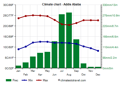
![]() Climate chart - Addis Ababa
Climate chart - Addis Ababa
The capital,
Addis Ababa, is located at 2,300 meters (7,500 ft) above sea level, though the altitude in the different districts of the city ranges from 2,100 to 2,700 meters (7,000 to 9,000 ft), and has a
mild and pleasant climate.
Nights are cool, even cold from November to February, when lows drop below 10 °C (50 °F). Days are pleasantly warm, around 23/25 °C (73/77 °F), except in July, August and September, at the height of the rainy season, when highs drop to about 20/21 °C (68/70 °F). The period from March to May, as often happens in Ethiopia, is the warmest of the year, albeit by a few degrees.
Throughout the year, 1,160 mm (46 in) of rain fall, with a maximum from June to September, which is the only remarkably rainy period. From November to February, there is little rain, and rare showers occur; from March to May, afternoon showers become a bit more frequent, occurring for 7/10 days per month, while in July and August, they occur nearly every day.
The amount of sunshine in Addis Ababa is good from October to May, while in the rainy season, from June to September, the sunshine hours decrease, and especially in July and August, the sky is often cloudy.

In the other cities located on the plateau, the climate is similar to that of Addis Ababa, with variations due to altitude and position.
The rainiest part of the plateau is the western one: in
Gore, 2,100 mm (83 in) of rain fall per year, and it rains a lot from April to October included.
In
Gondar, located in the north-west at an altitude of 2,000 meters (6,500 feet), the temperature is slightly higher than in Addis Ababa, and rainfall amounts to 1,100 mm (43 in) per year, distributed in the same way as in the capital.
In
Bahir Dar, at 1,800 meters (5,900 ft) above sea level, 1,400 mm (55 in) of rain fall, of which up to 430 mm (17 in) fall in July. Here, rainfall is enhanced by the waters of Lake Tana, from which the Blue Nile originates; the river gives rise to spectacular waterfalls near Tissisat.
 Jimma
Jimma (or Jima) is located at 1,700 meters (5,600 feet) above sea level in the south-west. Owing to the lower altitude, the temperatures are higher than in the capital, but they are still pleasant. Rainfall amounts to 1,500 mm (60 in) per year, including more than 100 mm (4 in) per month from April to September.
Harar (Harer) is located in the east, at the edge of the plateau, at no great distance from Dire Dawa (see below), but it is cooler because it is located at 1,850 meters (6,070 feet) above sea level, in addition, it's located on the other side. Here, 860 mm (34 in) of rain fall per year, with a rainy period from April to September, when monthly precipitation is between 100 and 140 mm (4 and 5.5 in).
2- Arid regions
The areas surrounding the Ethiopian plateau (zone 2 on the map) are arid or semi-arid, receiving less than 800 mm (31.5 in) of rainfall per year.
Also, due to the lower altitude, the climate is
hotter. The heat is intense especially below 1,000 meters (3,300 feet), and in a particular way in the dry period.
The narrow strip
west of the plateau, the one bordering Sudan and South Sudan, receives the south-west monsoon, but with less pronounced effects compared to the plateau. In this region, the heat is intense in the dry season, from October to mid-May, with a peak between April and early May, when the temperatures normally reach 40 °C (104 °F), then the rains come and the temperature drops a bit. So, it is difficult to find a good period to visit this area. In addition, the basins of the rivers Baro and Sobat, on the border with South Sudan, are marshy and unhealthy.
In the
far south, in the area of Lake Turkana, and in the south-east (see Moyale), scorching heat dominates throughout the year, with irregular rains, concentrated in two periods: from March to May and from October to November. Here, unlike in the rest of the country, the best time (or the least bad...) is from June to August, since it is the least hot, though slightly.

The Somali Region (Ogaden), in the south-east, is hot and semi-desert as well. Here, rainfall does not reach 250 mm (10 in) per year, and is concentrated in two rainy periods, April-May and October-November.
In
Gode, the maximum temperature ranges from 33 °C (91.5 °F) in July to 37 °C (98.5 °F) in February and March.
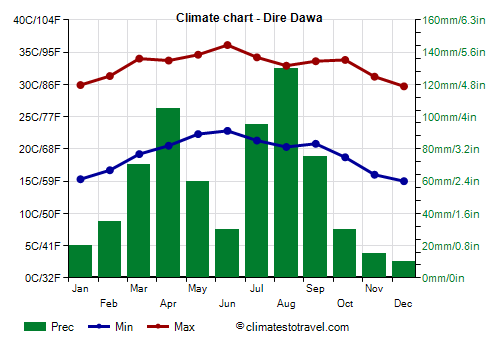
![]() Climate chart - Dire Dawa
Climate chart - Dire Dawa
In the east, we find
Dire Dawa, located at 1,200 meters (3,900 feet), on the north slope which overlooks the scorching zone: here, it's hot for most of the year, with a maximum in June, when highs around 35 °C (95 °F) are normal, while in winter, it's warm during the day, but nights are quite cool.
Here, 670 mm (26.5 in) of rain fall per year, with two relatively rainy periods, from March to May and from July to September, and two dry periods, from October to February and in June.
Around 100 km (62 mi) south-east of Dire Daura we find
Jijiga, where the climate is mild, since it is located at 1,600 meters (5,300 feet) of altitude. From November to February, it can get cold at night. In one year, 710 m (28 in) of rain fall, and the rainfall pattern is similar to that of Dire Daua.
The northernmost part of the plateau is quite arid, even though the altitude is higher: in
Mek'ele (or Makale), located at 2,000 meters (6,500 feet) of altitude in the Tigray region, 700 mm (27.5 in) of rain fall per year, with only two very rainy months, July and August. Despite the altitude, here, it can be a bit hot from April to June, with highs about 27/28 °C (81/82 °F).
3- Danakil
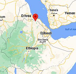 Danakil, where is located
In northern Ethiopia, in the Afar Region, the climate is desert and scorchingly hot throughout the year.
In particular, in the
Danakil Depression, where some salt lakes such as Lake Afrera are found, the climate is particularly hot, also because of the low altitude, which drops to 125 meters (410 feet) below sea level; here, the weather is permanently and overwhelmingly hot throughout the year.
The abandoned settlement of Dallol, in the far north, is considered the
hottest place in the world on average, having a daily temperature of 35 °C (95 °F) all year round: lows are around 30 °C (86 °F) and highs around 40 °C (104 °F), or at least these were the data reported at that time.
On the slopes of Erta Ale volcano, dark basalt rock absorbs the sun's rays and heats up in a particular way, thus creating a hellish environment.

Mountains
From the Ethiopian Plateau, several
mountain peaks rise, among which we find Ras Dashen, the highest of the country, 4,550 meters (14,928 feet) high, Abuna Yosef, 4,260 mt (13,976 ft), Tullu Deemtu, 4,389 mt (14,400 ft), and Batu, 4,307 mt (14,131 ft).
The last two are located in the Bale Mountains, where several interesting ecosystems are found: up to 2,800 meters (9,200 ft) we find the forest, replaced at higher altitudes by a barren mountain vegetation, able to withstand the cold of the night, while above 4,000 mt (13,000 ft), the constant cold prevents the growth of almost all kind of vegetation, which is why a cold desert is found.
On the contrary, Ras Dashen (in the north) and Abuna Yosef (in the east) are located in the semi-arid area.
Tropical cyclones
Occasionally, the south-eastern part of Ethiopia (Somali Region) can be affected by tropical cyclones coming from the Arabian Sea, which, after having affected Somalia, can penetrate inland, gradually weakening, but still bringing abundant rains, as happened for example with Deep Depression ARB 01 in November 2013 and with Cyclone Sagar in May 2018.
Cyclones form from May to December, though they are more frequent at the beginning of the period (May-June) and at the end (October-December).
When to go
The best time to visit Ethiopia is from
November to February, since it is the driest and coolest period of the year almost everywhere. In the arid areas, this is still a hot period at low altitude, with scorching days, but nights are usually with pretty cool.
The
worst months on the plateau are July and August because of the rainfall, and April and May in the semi-arid areas because of the heat, while the Danakil Depression is steadily scorching and inhospitable throughout the year (although it is probably a little less hot from December to February).
What to pack
In
winter: in the regions of Danakil and Afar, as well as in the south-east, bring loose-fitting, light-colored clothing, light and long shirts and pants of natural fibers (cotton, linen), a desert turban, and hiking shoes, and a sweatshirt for the evening at an altitude higher than the plain. In Addis Ababa and the plateau, bring spring/autumn clothes (light for the day), a sun hat, a jacket, and a sweater and a hat for the evening; for the high mountains, above 3,000 meters (9,800 ft), warm clothes, a warm jacket, gloves, and a scarf.
In
summer: in the regions of Danakil and Afar, as well as in the south-east, bring loose-fitting, light-colored clothing, light and long shirts and pants of natural fibers (cotton, linen), a desert turban, and hiking shoes. In Addis Ababa and the plateau, spring/autumn clothes, a jacket, a raincoat and umbrella; for the high mountains, above 3,000 meters (9,800 ft), warm clothes, a warm jacket, gloves, and a scarf.
Back to topSee also the
temperatures month by month