Select units of measurement for the temperature and rainfall tables (metric or imperial).
Average weather, temperature, rainfall, sunshine
In South Sudan, a country located north of the Equator which was born in 2011 as a result of the division of Sudan, the climate is
tropical, hot all year round, with a very hot, dry winter from December to February (which may be considered as the real summer), and a rainy summer from June to September, which is less hot but more humid.
The country is covered by a
plateau, which has an altitude between 400 and 700 meters (1,300 and 2,300 feet) in the center-north and between 700 and 1,000 meters (2,300 and 3,300 feet) in the south.
The predominant
vegetation is the savannah, more or less arid depending on area, while in the south-west, there are also forests, and in some areas crossed by rivers, there are wetlands, including the Sudd.
The
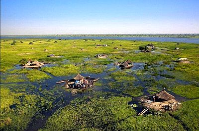
Sudd is largest swamp in the world, and it's situated in the north-central, along the course of the White Nile River and its tributaries, which are lost in a myriad of lakes, canals, lagoons, which are covered with aquatic plants and inhabited by a large number of species of land animals and birds. The summer rains increase the surface of the flooded areas.
Other areas rich in biodiversity are the Bandingilo National Park, the Boma National Park and the Southern National Park.

In much of the country,
precipitation is around 800/1,100 millimeters (31/40 inches) per year, with a minimum in winter, when it almost never rains, and a maximum in summer, usually in July and August.
The
driest areas are the extreme south-east, on the border with Kenya (where we find the Ilemi triangle, an area disputed with Kenya and Ethiopia) and the extreme north-east, on the border with Sudan. In both areas, rainfall drops below 700 mm (27.5 in) per year.
Instead,
the rainiest area (excluding the mountains) is found in the extreme southwest, near the border with Congo. Here, precipitation reaches 1,500 mm (60 in) per year.
In addition to some isolated
mountains in the far east on the border with Ethiopia, which reach 1,700/2,000 meters (5,600/6,500 feet), the only mountain range of some importance are the
Imatong Mountains, which are located in the south, near the border with Uganda, and whose highest point is Mount Kinyeti, 3,187 meters (10,456 feet) high. This is the rainiest area in the country, and it's covered with mountain forests. The temperature drops with increasing altitude, and on the summit, it's pretty cold all year round.
The climate in detail
North
During
winter, in December and January, a wind full of dust can blow in the country, especially in the north. Sometimes, it can be very hot during the day, with peaks of 40 °C (104 °F), especially at the lowest altitudes, while in other circumstances, it can get quite cold at night, with peaks about 8/10 °C (46/50 °F).
Between February and April, there is an increase in temperature, before the summer rains: during this period, the temperature can easily reach 40 °C (104 °F), with peaks of 45 °C (113 °F).
Malakal
 Malakal
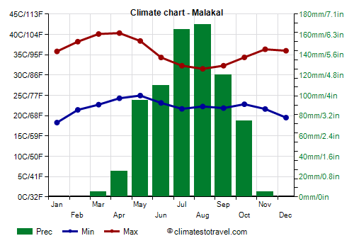
 is the capital of Upper Nile state and is located in the north, on the banks of the White Nile, at 400 meters (1,300 feet) of altitude. Temperatures are very high from November to May, with a maximum before the rainy season, in March and April.
Rainfall amounts to 730 mm (29 in) per year, and almost all of it occurs from May to October.
The sun often shines in the dry season, while in the rainy season it shines on average for a few hours a day.
South
In the south, where the rains arrive earlier, and especially in the south-west, where the altitude is also higher, the increase in temperature is less pronounced.
Juba
 Juba
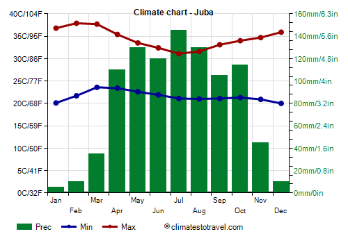
Juba, the capital, is located in the south, at about 500 meters (1,600 feet) above sea level. In January and February, it is a little hotter than in the north, but then the temperatures begin to decrease earlier.
Rainfall in Juba amounts to 955 millimeters (38 inches) per year, so it is a little more abundant than in the north. Moreover, the rainy period is longer, in fact, more than 100 mm (4 in) of rain fall already in April.
In Juba too, the sun regularly shines in the dry season, while in the rainy season, the sunshine hours decrease a little.
Yambio

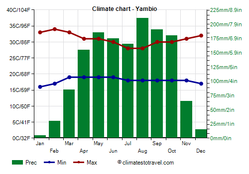
As mentioned, in the far south-west, the temperatures are more uniform throughout the year, in particular, the heat is less intense in the period from February to April, also because the rains arrive earlier.
In
Yambio, located at 650 meters (2,100 ft) above sea level, in the state of Western Equatoria, a short distance from the border with Congo, highs reach 34 °C (93 °F) in February.
In this area, the rains are abundant, around 1,400 mm (55 in) per year; the rainy season is long, and precipitation exceeds 150 mm (6 in) per month from April to October.
When to go
It's hard to find the
best time to visit South Sudan, since hot winter in winter is followed by a rainy summer.
However, given the risk of flooding in large areas in the period of the summer rains, you can choose the
winter, and in particular, the months of December and January. The weather is sunny, but it is hot during the day, while at night, it can sometimes be a bit cold.
Between February and April, the heat increases even more, and becomes really intense, except in the south-west and in the mountains.
What to pack
In
winter: bring light clothes for the day, loose-fitting and of natural fabric (cotton or linen), a turban for the wind from the desert, a jacket and a sweater for the evening, and comfortable boots.
In
summer: bring light clothes, an umbrella or a light raincoat for the rain showers, a light sweater. For the highest areas of the plateau, around a thousand meters (3,300 feet), you can add a light jacket.
It's better for women to avoid shorts and miniskirts.
Climate data - South Sudan
| Juba (460 meters) |
|---|
|
| Jan | Feb | Mar | Apr | May | Jun | Jul | Aug | Sep | Oct | Nov | Dec |
|---|
| Min temp. | 20 | 22 | 24 | 23 | 23 | 22 | 21 | 21 | 21 | 21 | 21 | 20 |
|---|
| Max temp. | 37 | 38 | 38 | 35 | 34 | 32 | 31 | 32 | 33 | 34 | 35 | 36 |
|---|
| Precip. | 5 | 10 | 35 | 110 | 130 | 120 | 145 | 130 | 105 | 115 | 45 | 10 |
|---|
| Prec. days | 1 | 2 | 7 | 12 | 12 | 10 | 13 | 12 | 9 | 10 | 7 | 2 |
|---|
|
|
| Sun hours | 9 | 8 | 7 | 7 | 7 | 7 | 6 | 7 | 8 | 8 | 8 | 8 |
|---|
|
| Malakal (385 meters) |
|---|
|
| Jan | Feb | Mar | Apr | May | Jun | Jul | Aug | Sep | Oct | Nov | Dec |
|---|
| Min temp. | 18 | 21 | 23 | 24 | 25 | 23 | 22 | 22 | 22 | 23 | 22 | 20 |
|---|
| Max temp. | 36 | 38 | 40 | 40 | 38 | 34 | 32 | 32 | 32 | 34 | 36 | 36 |
|---|
| Precip. | 0 | 0 | 5 | 25 | 95 | 110 | 165 | 170 | 120 | 75 | 5 | 0 |
|---|
| Prec. days | 0 | 1 | 3 | 4 | 9 | 10 | 12 | 12 | 7 | 4 | 0 | 0 |
|---|
|
|
| Sun hours | 10 | 9 | 8 | 9 | 7 | 6 | 5 | 6 | 6 | 7 | 9 | 10 |
|---|
|
| Renk (280 meters) |
|---|
|
| Jan | Feb | Mar | Apr | May | Jun | Jul | Aug | Sep | Oct | Nov | Dec |
|---|
| Min temp. | 17 | 18 | 21 | 24 | 26 | 24 | 23 | 23 | 24 | 23 | 21 | 18 |
|---|
| Max temp. | 34 | 37 | 40 | 41 | 39 | 37 | 33 | 33 | 34 | 37 | 37 | 35 |
|---|
| Precip. | 0 | 0 | 0 | 5 | 30 | 75 | 120 | 105 | 95 | 45 | 0 | 0 |
|---|
| Prec. days | 0 | 0 | 0 | 1 | 3 | 6 | 10 | 10 | 8 | 4 | 0 | 0 |
|---|
|
|
| Sun hours | 10 | 10 | 9 | 9 | 8 | 6 | 5 | 6 | 6 | 8 | 10 | 10 |
|---|
|
| Yambio (650 meters) |
|---|
|
| Jan | Feb | Mar | Apr | May | Jun | Jul | Aug | Sep | Oct | Nov | Dec |
|---|
| Min temp. | 16 | 17 | 19 | 19 | 19 | 19 | 18 | 18 | 18 | 18 | 18 | 17 |
|---|
| Max temp. | 33 | 34 | 33 | 31 | 31 | 30 | 28 | 28 | 30 | 30 | 31 | 32 |
|---|
| Precip. | 5 | 30 | 85 | 155 | 185 | 175 | 165 | 210 | 190 | 180 | 65 | 15 |
|---|
| Prec. days | 1 | 4 | 8 | 14 | 15 | 16 | 15 | 18 | 17 | 16 | 7 | 2 |
|---|
|
|
|
|