Average weather, temperature, rainfall, sunshine hours
The Way of St. James (Camino de Santiago), of which the Cathedral of
Santiago de Compostela is the final destination, is actually made up of several paths.
It is possible to cover only a section of the path, in particular, it is easy to start from cities that can be reached by plane.
Northern Way
The
Northern Way (Camino del Norte) or Ruta de la Costa runs along the Cantabrian coast from Irún, in the
Basque Country, to Ribadeo, in
Galicia, crossing
Cantabria and
Asturias, then heads towards Santiago.
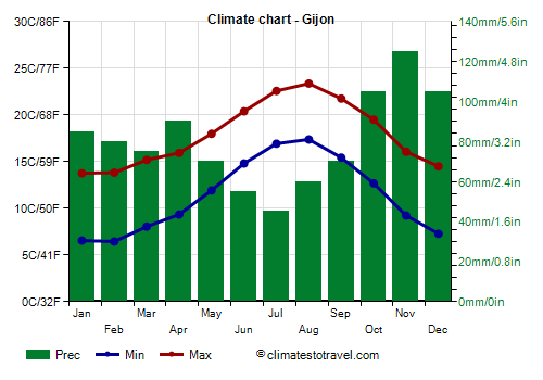
In this area (see for example
Gijón), the climate is
temperate oceanic, similar to that of Santiago de Compostela, with frequent rains especially from October to May. Even in summer there are several cool and cloudy days, with intermittent rains.
Together with the short English Way, which starts from the north coast just 100 km (60 mi) from the destination, and the Original Way (Camino Primitivo), which starts from Oviedo, the Northern Way is the least at risk of hot days in summer. However, in certain areas, such as that of
Bilbao, when the wind from the south manages to climb over the mountains and reach the coast, very hot days can occur, with peaks of 38/40 °C (100/104 °F) from June to August or early September.
In this route, there are several ascents and descents, even though it does not reach considerable heights (the highest altitude being 700 meters or 2,300 feet). In addition, there are dirt roads that can become muddy during the rains.
In winter, cold and windy days are possible, with highs around 5 °C (41 °F), and lows around freezing or a little below. Sometimes it can even snow, especially in the hill areas.
French Way
The
French Way (Camino Francés) starts from Saint-Jean-Pied-de-Port and runs through the north of Spain parallel to the coast, but it crosses the northern part of the Spanish plateau (it passes through cities such as
Logroño,
Burgos and
León). This is the most popular route, and is largely made up of asphalted or gravel roads.
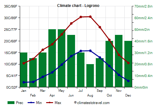
In this area, the climate is
slightly continental, and it can get cold in winter, with lows below freezing, sometimes down to -10 °C (14 °F) and very hot in summer, with highs around 40 °C (104 °F), especially in July and August, but sometimes also in June and early September. Here are the average temperatures in Logroño, 400 meters (1,300 feet) above sea level (one of the lowest points of the route).
In the first section of the French Way, where you have to cross the Pyrenees, you reach the 950 meters (3,115 feet) of
Roncesvalles (in
Navarre), an altitude at which snow and frost can be found from November to April.
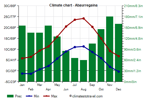
To get an idea of the temperatures of this area, we can refer to the averages of
Abaurregaina/Abaurrea Alta, located at 1,050 meters (3,445 ft), just south of Roncesvalles. Here, the night temperature can drop to 0 °C (32 °F) even in May and October, and to 3/5 °C (37/41) in summer. The records are -18 °C (-0.5 °F), set in January 1985, and 38 °C (100.5 °F), set in August 1987.
One of the two roads to Roncesvalles, the Napoleón Route, passes through the Col de Lepoeder, at 1,450 meters (4,757 ft) above sea level, where snow and frost are even more frequent (sometimes it can snow even in May). However, this road is closed due to bad weather from November to March (and those who try to take it anyway are heavily fined...); in this period, you will have to take the easier road that passes through Valcarlos.
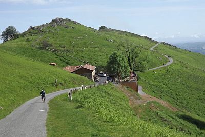
In the central part, the French Way again exceeds 1,000 meters (3,300 ft) of altitude, reaching 1,200 meters (3,900 ft), near San Juan de Ortega, a short distance from Burgos. We are in the northern part of the Iberian System.
An even higher altitude is reached in the western part of the province of
Castile and León, where it reaches 1,500 meters (4,900 ft) at the summit where the
Cruz de Ferro (iron cross, where by tradition the pilgrims leave a stone) is found. Even though we are not in the Pyrenees, it can get cold: at 1,500 meters (4,900 ft), the temperature is 8-10 degrees Celsius (14-18 °F) lower than at sea level. Further west, now in Galicia and just over 100 km (60 mi) from Santiago de Compostela, it arrives at 1,300 meters (4,265 ft) in O Cebreiro, and then at 1,337 meters (4,386 ft) at the Alto do Poio.
Portuguese Way
The
Portuguese Way (Camino Portugués) starts from Lisbon (in
Portugal) and stays close to the Atlantic coast until reaching Santiago.
Here the climate is
mild, rainy in winter, especially in the north, and often sunny in summer. However, in the southern section, from
Lisbon to
Coimbra via
Santarém, which is further away from the coast, it is possible to bump into very hot days in summer.
Sourthern ways
Then there are the paths that start from the south and connect to the French way near Astorga. Having to cross the Spanish plateau in the central-southern part, they are those most at risk of running into
very hot days in summer.
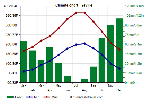
The
Via de la Plata, which starts from
Seville and passes through
Mérida,
Cáceres and
Salamanca, and the
Mozarabic Way, which starts from Almería or
Málaga and then connects to the via de la Plata near Mérida, having to pass through the Baetic Depression in Andalusia, are the least indicated in summer. Even in
Extremadura, north of Andalusia, the temperature can reach 45 °C (113 °F) in summer.
The
Wool Route (Ruta de la lana), which starts from
Alicante, and that of
Madrid, also cross hot areas.
Best Time
If you walk a short stretch of a given route, you can refer to the climate of that area, or of the nearest city.
- If you intend to travel the north coast (Northern Way) or the shorter routes near Santiago (English Way and Primitive Way), you can choose the period from June to September, because it is the mildest and least rainy of the year, and because in these areas, very hot days are rare and sporadic. However, if you fear the heat, you can choose the months of May and October (when, however, the rains are more frequent).
- If you follow the French or Portuguese Way, you can exclude the period from June to September, which can be very hot, and therefore choose the months of May and October.
However, in June, it is not always as hot as in July and August, and the days are very long: you can therefore leave very early in the morning, and arrive at the destination of the stage before the hottest hours.
- If you take one of the paths that start from the south, where the heat is more likely, more intense and lasts longer, you can choose the month of April, and the period from mid-October to mid-November.
If you want to travel in winter, the best routes are the southernmost ones, where mild and sunny days are more frequent.
What to pack in the suitcase
In general, you need to dress in layers, both because you will walk at different times of the day, and because you can meet different types of weather.
Also, it is a good idea not to overload the backpack and not to exceed 5 kg (11 pounds) in weight. Prefer synthetic and light materials. However, as you pass through several cities, if something is missing you can buy it on the spot (although from 2 to 5 pm, you can find closed shops and pharmacies).
Some prefer cushioned running shoes to hiking boots, which can be too hard over long distances and on asphalt.
In
spring and autumn, when walking, the body tends to produce heat, so the most important thing is to protect the extremities. It is useful to bring gloves and a wool hat for cold days, and maybe a light scarf to protect your neck.
Jackets that are too heavy could be uncomfortable and take up space when not in use, and could make you sweat. Better to achieve adequate protection by adding layers.
A fleece sweatshirt, a breathable merino shirt with thermal insulation.
Rain pants and poncho for when it rains.
In
summer, it is advisable to bring a sun hat and sunglasses. Drink a lot, also because when it is hot, the air is often dry.
Even if it is hot during the day, at night the temperature drops a lot, so you have to bring some warm clothes too.
A lightweight synthetic sleeping bag even in summer (it is true that you sleep in the "albergues", but sometimes there are bedbugs in the beds, so it is useful to have a sleeping bag on hand, which can be easily washed and dried). A rechargeable headlamp.
Rain pants and poncho for when it rains (it can also happen in summer, especially along the north coast).