Select units of measurement for the temperature and rainfall tables (metric or imperial).
Average weather, temperature, rainfall, sunshine hours
The climate of Castile and León is
slightly continental and semi-arid on the plateau (Meseta) that occupies most of the region, while it is colder and rainy (and snowy in winter) in the mountains.
The Autonomous Community is located in the north-west of Spain and has no access to the sea. It is largely occupied by the northern part of the Spanish Meseta, which has an average altitude of 800 meters (2,600 feet).
In the north-west, in the comarca of Bierzo, where Ponferrada is located, the altitude drops below 500 meters (1,650 ft), while in the north-east, near the border with the Basque Country (see Valle de Mena), it drops below 200 meters (655 ft). Also in the extreme south, the altitude drops to about 300 meters (985 ft), in the Embalse de Rosarito.

The region is surrounded by
mountains. To the north, the Cantabrian mountain range isolates the region from the mild and humid currents of the Atlantic. The highest peak of the community is Torre Cerredo, 2,648 meters (8,688 ft) high, on the border with Asturias and Cantabria, in the Picos de Europa mountain group.
Consequently,
precipitation is quite scarce on the plateau, where it varies between 400 and 550 millimeters (15 and 20 inches) per year. The rainiest seasons are spring and autumn, the driest the summer. In winter, rainfall is not abundant. In the mountainous areas, on the other hand, precipitation is more abundant and exceeds 1,500 mm (60 in) per year.
In the center-south of the region we find other mountain ranges, which are part of the Central System ("Sistema Central"). In the southwest, the Sierra de Béjar, where the La Covatilla ski resort is located, and the Sierra de Gredos. In the south-east, the sierra de Guadarrama, beyond which we find the Community of Madrid, and the Sierra de Ayllón.
To the east, in the province of Burgos, we find a small part of the Iberian System ("Sistema Ibérico").
Castile and León is crossed by two of the longest
rivers on the Iberian Peninsula. The Ebro, which has its source in Cantabria near Reinosa, crosses the northern part of Castile and León up to Miranda de Ebro and then heads towards the Mediterranean. The Duero has instead its source in the pico Urbión, in the Iberian System, then crosses Soria, passes just south of Valladolid, crosses Zamora and then heads towards Portugal (and flows into the sea near the city of Oporto).
In the northern part of Castile and León is the French route of the
Camino de Santiago, which runs through the cities of Burgos, León and Ponferrada.
Salamanca

In
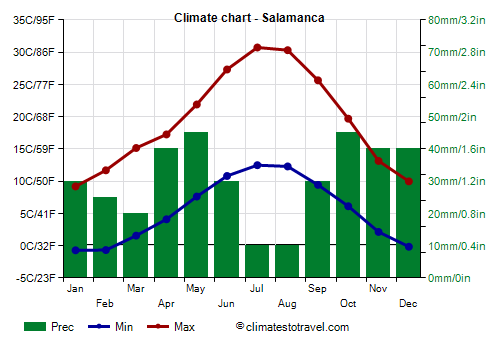
Salamanca, located 800 meters (2,600 ft) above sea level, 175 km (110 mi) north-west of Madrid, the average temperature ranges from 4.2 °C (39.5 °F) in January to 21.6 °C (71 °F) in July.
Here are the average temperatures.
Salamanca - Average temperatures (1991-2020) |
| Month | Min | Max | Mean |
|---|
| January | -0.7 | 9.2 | 4.2 |
|---|
| February | -0.7 | 11.7 | 5.5 |
|---|
| March | 1.6 | 15.2 | 8.4 |
|---|
| April | 4.1 | 17.2 | 10.7 |
|---|
| May | 7.6 | 21.9 | 14.8 |
|---|
| June | 10.8 | 27.3 | 19.1 |
|---|
| July | 12.5 | 30.7 | 21.6 |
|---|
| August | 12.3 | 30.3 | 21.3 |
|---|
| September | 9.4 | 25.6 | 17.5 |
|---|
| October | 6.1 | 19.7 | 12.9 |
|---|
| November | 2.1 | 13.1 | 7.6 |
|---|
| December | -0.2 | 10 | 4.9 |
|---|
| Year | 5.5 | 19.4 | 12.4 |
|---|
Rainfall in Salamanca amounts to just 375 mm (14.8 in) per year.
Salamanca - Average precipitation| Month | Days |
|---|
| January | 30 | 6 |
|---|
| February | 25 | 5 |
|---|
| March | 20 | 5 |
|---|
| April | 40 | 7 |
|---|
| May | 45 | 8 |
|---|
| June | 30 | 4 |
|---|
| July | 10 | 2 |
|---|
| August | 10 | 2 |
|---|
| September | 30 | 4 |
|---|
| October | 45 | 7 |
|---|
| November | 40 | 7 |
|---|
| December | 40 | 7 |
|---|
| Year | 375 | 64 |
|---|
Castile and León is a
sunny region, especially in the south-central part of the plateau, where there are more than 2,500 hours of sunshine per year. In the north, in cities like Ponferrada and León, there are 2,200/2,300 hours of sunshine per year. The sun can shine even in winter, although fog can sometimes form.
Here are the average sunshine hours per day in Salamanca.
Salamanca - Sunshine hours| Month | Average | Total |
|---|
| January | 4 | 120 |
|---|
| February | 5.5 | 155 |
|---|
| March | 7 | 210 |
|---|
| April | 7.5 | 225 |
|---|
| May | 8.5 | 265 |
|---|
| June | 10.5 | 315 |
|---|
| July | 11.5 | 360 |
|---|
| August | 10.5 | 330 |
|---|
| September | 8.5 | 250 |
|---|
| October | 6 | 185 |
|---|
| November | 4.5 | 130 |
|---|
| December | 3.5 | 105 |
|---|
| Year | 7.2 | 2645 |
|---|
The seasons
In winter, cold air stagnates on the plateau, and in periods of good weather, as we have said,
fog can form, especially near waterways, and in the months of December and January. On average, there are 45 days with fog per year in Valladolid, 39 in Salamanca, 34 in Burgos and 30 in Zamora.
During the night, the temperature quite often drops below freezing. On average, there are 87 days with frost (minimum temperature below freezing) per year in Ávila, 83 in Soria, 81 in Valladolid, 77 in Salamanca, 72 in León, 48 in Zamora, and 43 in Ponferrada.
Although
cold waves in Spain are less frequent than in other European countries, when they do occur, Castile and León is particularly exposed, due to the location in the north of the country and to the altitude, as well as the distance from the sea. In these cases, the temperature can drop as low as -15 °C (5 °F) and even below. Intense cold waves were recorded in January 1945, February 1963 and January 1971. The cold record is -22 °C (-7.5 °F) in Burgos, -20 °C (-4 °F) in Salamanca, -17.5 °C (0.5 °F) in León, -16 °C (3 °F) in Ávila and Valladolid, and -10.5 °C (13 °F) in Ponferrada, which is located outside the plateau and at a lower altitude.
Sometimes, it can even
snow. Snow is more frequent in northern cities and in those at higher altitudes. On average, 21 days with snow per year occur in Soria, which is located at 1,050 meters (3,445 ft) above sea level, and which is the highest number in all of Spain (excluding the mountains), 20 days in Ávila, 18 in Burgos, 13 in León, 7 in Salamanca and only 3 in Zamora, which is located at an altitude of 650 meters (2,130 ft) and in the southwest of the region. However, snow does not always manage to accumulate on the ground.
In summer, the
heat in Castile and León is not as intense as in Madrid and central-southern Spain, both for the altitude and for the position further to the north, however, sometimes it can get very hot.
The hottest cities are those located to the south and at a lower altitude. The temperature exceeds 35 °C (95 °F) for 6 days a year in Palencia, Ponferrada and Salamanca, 3 and a half days in Burgos and Segovia, 2 days in Soria, and just one day in León and Ávila. In the main cities, the heat record is typically 38/39 °C (100/102 °F), but it is 40 °C (104 °F) in Valladolid and 41 °C (106 °F) in Zamora.
However, the temperature drops rapidly after sunset, so nights are often cool. On certain occasions, it can sometimes even get a little cold, with lows of 7/8 °C (45/46 °F) even in July and August.
Best Time
To visit Castile and León you can choose the periods from mid-May to mid-June and from mid-September to mid-October, to avoid both the summer heat and the winter cold. In the northernmost part (see Burgos, León, Ponferrada), where very hot days are rare, and in the mountains, you can also choose the period from June to September.
See also the
temperatures by month.