Select units of measurement for the temperature and rainfall tables (metric or imperial).
Average weather, temperature, rainfall, sunshine hours
In much of Extremadura, an autonomous community in southwestern Spain, the climate is
continentalized Mediterranean, with mild, relatively rainy winters and particularly hot, sunny summers.
However, there are also mountainous areas, where the climate is colder.
In the cold semester, disturbances from the Atlantic pass quite often (to the west, the region borders with Portugal), but there are also sunny periods. In winter, in periods of good weather, it can get cold at night, the temperature can drop slightly below freezing, and fog can form.
In summer, the high pressure of the Azores prevails, but due to continentality and the possible influx of hot air from Africa, there are several
scorching days, with highs that can exceed 40 °C (104 °F).
The region is largely occupied by a lowland and low hills, between 200 and 450 meters (650 and 1,450 feet) above sea level. The main town,
Badajoz, is located at 185 meters (600 ft). The capital, Mérida, is at 215 meters (700 ft), Plasencia is at 415 meters (1,350 ft), while
Cáceres is at 450 meters (1,450 ft).
Precipitation in Extremadura is generally not abundant, and varies between 400 and 600 millimeters (15.5 and 23.5 inches) per year in the main cities. In the mountains, it reaches 1,000 mm (40 in) in the Sierra de Guadalupe (or Sierra de las Villuercas), and exceeds 1,500 mm (60 in) in the Sierra de Gredos.
Extremadura is crossed by two important
rivers. The Tagus, the longest river in the Iberian Peninsula, flows in the north of the region, and heads towards Portugal, where it will flow into the sea near Lisbon. Further south, the Guadiana River passes through the cities of Mérida and Badajoz, and then marks the border with Portugal for many kilometers, heading towards the Gulf of Cadiz.

In the capital,
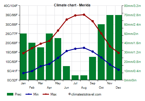
Mérida, located in the center of the region, 215 meters (700 ft) above sea level, the average temperature ranges from around 9 °C (48 °F) in January to around 26 °C (79 °F) in July and August. Here are the average temperatures.
Merida - Average temperatures (1991-2020) |
| Month | Min | Max | Mean |
|---|
| January | 3.8 | 14.5 | 9.2 |
|---|
| February | 4.9 | 17.2 | 11 |
|---|
| March | 7.5 | 19.6 | 13.6 |
|---|
| April | 8.7 | 21.1 | 14.9 |
|---|
| May | 12 | 26.7 | 19.4 |
|---|
| June | 15.7 | 32.6 | 24.2 |
|---|
| July | 16.9 | 34.8 | 25.8 |
|---|
| August | 17.4 | 35.2 | 26.3 |
|---|
| September | 15.4 | 31.7 | 23.6 |
|---|
| October | 12.2 | 25.1 | 18.6 |
|---|
| November | 8.4 | 18.2 | 13.3 |
|---|
| December | 5.6 | 14.7 | 10.1 |
|---|
| Year | 10.7 | 24.3 | 17.5 |
|---|
Precipitation amounts to 470 mm (18.5 in) per year. Autumn is the wettest season.
Merida - Average precipitation| Month | Days |
|---|
| January | 50 | 10 |
|---|
| February | 40 | 9 |
|---|
| March | 35 | 8 |
|---|
| April | 50 | 9 |
|---|
| May | 45 | 8 |
|---|
| June | 15 | 2 |
|---|
| July | 5 | 1 |
|---|
| August | 5 | 2 |
|---|
| September | 25 | 5 |
|---|
| October | 60 | 10 |
|---|
| November | 70 | 10 |
|---|
| December | 70 | 13 |
|---|
| Year | 470 | 86 |
|---|
Extremadura is a
sunny region. In the main cities there are more than 2,800 hours of sunshine per year.
Merida - Sunshine hours| Month | Average | Total |
|---|
| January | 4.5 | 145 |
|---|
| February | 6 | 165 |
|---|
| March | 7.5 | 225 |
|---|
| April | 8 | 245 |
|---|
| May | 9.5 | 290 |
|---|
| June | 11 | 335 |
|---|
| July | 12 | 375 |
|---|
| August | 11 | 340 |
|---|
| September | 8.5 | 260 |
|---|
| October | 6.5 | 205 |
|---|
| November | 5 | 155 |
|---|
| December | 3.5 | 115 |
|---|
| Year | 7.8 | 2860 |
|---|

As mentioned, in Extremadura there are also
mountainous areas. In the south, on the border with Andalusia, we find the
Sierra Morena, whose highest mountains are located further east, in Castile-La Mancha. In Extremadura only 1,100 meters (3,600 ft) are reached. At 750 meters (2,450 ft) above sea level we find Monesterio, the highest point of the Via de la Plata (in the
Camino de Santiago), at least in the central-southern part.
In the central-eastern part of Extremadura we find the Sierra de Guadalupe, which reaches 1,600 meters (5,250 ft).
To the north, on the border with Castile and León, we find the much higher mountains of the
Central System, with the subsystems of the Sierra de Gata, Sierra de Béjar and Sierra de Gredos. The highest peak in Extremadura is Mount Calvitero, 2,401 meters (7,877 ft) high.
These mountains protect Extremadura from cold air masses that descend from the north.
For this reason,
snow is very rare in major cities, where you have to wait many years to witness a snowfall. As altitude increases, snow naturally becomes more frequent. Already in Monesterio, from time to time you can see quite abundant snowfalls. In the high mountains, snow is frequent and abundant.
Best Time
To visit Extremadura you can choose the months of April and May and from mid-September to mid-October, to avoid the summer heat, although in these periods it can sometimes rain. Those who can stand the heat can choose summer, getting ready to walk around the cities with scorching heat.
See also the
temperatures by month.