Select units of measurement for the temperature and rainfall tables (metric or imperial).
Average weather, temperature, rainfall, sunshine
In Thailand, the climate is
tropical, with greater temperature variations in the centre-north, and rains due to the monsoons.
Typically, there are three distinct seasons. Winter, from November to February, is a dry and relatively cool season, in which the
northeast monsoon prevails, coming from the Asian continent. However, the coolness is felt in the north and in inland areas, while on the coast and in the south, it is hot even in winter. Then there is a very hot season from March to mid-May, which precedes the rains, and a rainy season determined by the
south-west monsoon, which generally runs from mid-May to October.
In the southern
peninsular region, where beaches and renowned resorts are found, the rainy season has a different pattern than in the continent, which will be discussed later.
The map below shows the climate zones of Thailand, based mainly on the rain pattern.
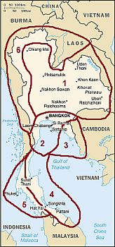
The climate in detail
1- The north

In the
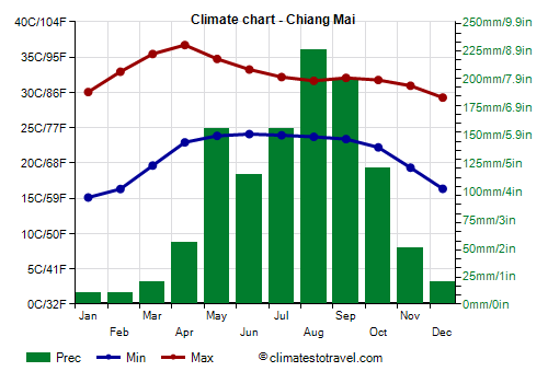
northern inland plains, and in the valleys of the north-western hilly area, the climate is hot for most of the year, except in winter, when it's sunny during the day but a bit cool at night, especially in December and January (and a little less in February), when night-time temperatures drop to around 16/17 °C (61/63 °F) in the center and to 14/15 °C (57/59 °F) in the north.
When cold air masses arrive from China, in northern cities such as
Chiang Mai, Lampang and Udon Thani, in December and January the night temperature can drop to around 5 °C (41 °F) and in some cases even below. However, by February the daytime temperature begins to rise, and often reaches 34/35 °C (93/95 °F), and then between March and May it rises up to 36/38 °C (97/100 °F), with peaks above 40 °C (104 °F).
In
Lampang, a city located in the north-west at 240 meters (790 feet) above sea level, the highest record is 43.5 °C (110.5 °F), set in April 2016.

The
monsoon rains go to mid-May to mid October. Annual precipitation in the plains and valleys of the north is between 1,000 and 1,500 millimeters (40 and 60 inches), with a similar pattern: scarce and rare rains from mid-November to April and heavy rains during the monsoon period, with a peak in the first part (May) and in the final one (August and September).
The amount of sunshine is very good in the dry season, from December to April, when clear skies prevail, while it's not high in the monsoon period, from June to September, when there are several cloudy periods.
The best time in this area corresponds to the months of December and January, since it often happens that in February the heat is already intense, especially in the south-central part of the plain.
2- Bangkok and surrounding areas

In the southernmost part of the plain, the climate is similar, but winter is warmer, and cool periods are very rare and less pronounced. Here too, the hottest time of the year runs from late February to mid-May, before the monsoon.
In
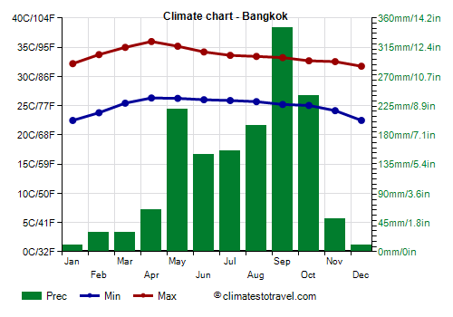
Bangkok, the capital, the daytime temperature reaches 32 °C (89.5 °F) even in the least hot month, December, while in April and May it reaches 35/36 °C (95/97 °F).
Throughout the year, 1,650 mm (65 in) of rain fall. The wettest months are at the beginning and the end of the monsoon, namely May, September and October.
The best time in Bangkok is from December to mid-February, since it is the least hot and outside of the rainy season.
South-east of Bangkok,
Pattaya has a climate similar to that of the capital, but it is located in a stretch of coast (which goes down to Sattahip) relatively sheltered from the summer rains: from June to August, an average of about 100 mm (4 in) of rain falls per month.
Of course, we are still in a hot and muggy season, when there's not much sun, and sometimes tropical storms and typhoons can affect the area (see below), in short, the weather from June to August is not so inviting, but if you are lucky it may be acceptable. The rainiest months in Pattaya are May, September and October, that is, the beginning and the end of the rainy season.
The best time here is from December to February, with March and April still dry and sunny, but a bit hot (though not as hot as in the interior).
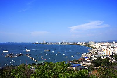
The coastal stretch to the south-west of Bangkok, down to Ao Noi, is quite sheltered as well, in fact the rainfall in summer is not copious, and the total annual precipitation is about 1,000/1,200 mm (40/47 in).
3- The rainy coast

South-east of Pattaya, starting from Rayong, the summer rains are more abundant, and they are plentiful in the easternmost portion (see Chanthaburi, Trat,
Koh Chang), where summer is definitely not recommended. In Rayong, 1,700 mm (67 in) of rain fall per year, and in Koh Samet 1,340 mm (53 in), while in Chanthaburi, precipitation reaches as high as 2,800 mm (110 in), and in Trat up to 3,500 mm (138 in).
However, here too the winter is dry and sunny, and here too the best time is from December to February; in March and April, it's warmer, but the weather is sunny, despite the first short pre-monsoon showers.
4,5 - Peninsular Thailand
In
Peninsular Thailand, the climate is hot all year round. The increase in temperature between March and May is not as intense as in the continental region, so these months are only slightly warmer than the rest of the year: highs are around 33/34 °C (91/93 °F) instead of 31/32 °C (88/90 °F), although sometimes it can get very hot here as well. Additionally, in the peninsular area, the rainy season occurs at different times depending on the side. Let's see when.

Along the
east coast, overlooking the Gulf of Thailand (or Gulf of Siam), from Chumphon to the border with Malaysia, the summer monsoon is not felt in a particularly intense way, so much so that in summer, which is considered high season, the area is frequented by many tourists. On the contrary, the so-called retreating monsoon, in the early months (October to December), when the sea is still warm and able to provide energy and moisture, brings heavy rainfall, sometimes torrential.
In
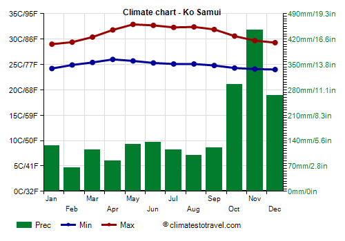
Ko Samui, an island located in the Gulf of Thailand, the rains are quite frequent in summer, but on the whole they are not abundant, while they become definitely abundant in October and November.
From May to September, when south-westerly winds prevail, temperatures on the east coast are higher, as the winds come from the interior and the rains do not last long.
Sometimes the rains continue until the beginning or the middle of January, so in this area, which also includes Pattani and
Songkhla, the best time is from the middle or the end of January to April (with a preference for February, since here too March and April are a bit hot).
Despite the different rainfall pattern, the (relatively) cloudiest season is June-October on the east coast as well, although there's not much more sun even from November to January.
In Ko Samui, and in general in Thailand, the sea is warm all year round.

Along the
west coast, overlooking the Andaman Sea (see the Similan Islands, Phuket,
Krabi, the
Phi Phi Islands, Koh Lanta, Koh Lipe), summer is very rainy, since the monsoon hits the coast directly from the sea, while there's little rain from December to March.
In addition, during the summer monsoon the sea can be rough, and reaching the islands by boat can be difficult.

In
Phuket, from December to March, rainfall drops below 100 mm (4 in) per month.
The amount of sunshine on the west coast is quite limited in the May-October period, while the sun often shines from January to March.
The temperatures in winter are a little higher than on the east side, because the winds blow from the mainland (or rather, from the interior of the peninsula).
So, on the western side the best time is from late December to March; in April, pre-monsoon showers are more frequent than elsewhere.

6 - Mountains

In the western part of Thailand, along the border with Burma, and in the north along the border with Laos, there are
mountain ranges, with peaks exceeding 2,000 meters (6,500 feet).
Above 1,000 meters (3,300 feet), the climate is cool in winter, with mild days and cold nights, and comfortably warm in the rest of the year.
In mountainous areas, the monsoon rains are generally more intense, and even in the period before the monsoon, some showers may occur in the afternoon, so this area is usually covered by rainforests. In the valleys between the mountains, major rivers such as the Mekong and the Salween flow, which afterwards reach the plain.
Cyclones
Let us talk now about tropical cyclones.
Cyclones coming from the Pacific Ocean, known as
typhoons, follow a trajectory from east to west: when they pass to the north, they affect the continental part of Thailand after releasing the bulk of energy over Vietnam, Laos and Cambodia, however, they can still bring heavy rains. When they follow a more southern trajectory, they can affect more directly the peninsular part of Thailand. They generally affect Thailand from June to December, although they are more frequent from September to November.
On the other hand,
cyclones coming from the Indian Ocean, follow a trajectory from east to west, or from south to north, and affect the Andaman Sea in the early stages of their formation, or they can hit the continental part of Thailand after having affected in a more direct way Burma (or Myanmar). They are rarer than typhoons, and are formed more easily between April and December, with two peaks at the beginning and at the end of the period (April-June and October-December). However, given the warm sea, they can in theory form all year round, especially in the southern part.
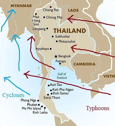
In general, Thailand is not hit as hard as other countries of Southeast Asia, such as the Philippines or Vietnam. In particular,
Peninsular Thailand is located in an area fairly sheltered from tropical cyclones, and in recent decades it has been directly affected only from mid-October to around December 20 (but in 2019 a tropical storm, Pabuk, affected the area in early January).
However, a typhoon that hit this area in a particularly hard way was Gay, which affected the Gulf of Thailand in early November 1989; another one was Forrest in mid-November 1992.
If it were not for the risk of cyclones, November would already be a good month in many parts of the country.
El Niño and La Niña
The climate of Thailand is affected by the cycle, called ENSO, that includes the periods of El Niño and La Niña.
In particular, during
El Niño years, the December-February period is drier than normal in the part of Peninsular Thailand exposed to the rains (the eastern one), while the rest of the country, which in this period is normally dry, becomes hotter than normal.
On the contrary, in
La Niña years, the December-February period may be rainier in Peninsular Thailand, even in areas that are normally dry.
For example, in January 2012, a weak La Niña year, 325 mm (12.8 in) of rain fell in Ko Samui (which, however, is on the east side, which in this period is still quite rainy), and up to 475 mm (18.7 in) in Krabi.
In March 2011, a moderate La Niña year, things got much worse, in fact there were
floods in the south of the country: 435 mm (17.1 in) fell in Krabi, of which 185 mm (7.3 in) fell in a single day, 230 mm (9 in) in Ko Lanta, 375 mm (14.8 in) in Phuket, 560 mm (22 in) in Songkhla, 785 mm (31 in) in Surat Thani, and up to 1,135 mm (44.7 in) in Ko Samui! Especially in the last two weeks of the month, the rains occurred almost daily, and some tourist resorts were closed. In January too, however, it had rained enough: 135 mm (5.3 in) in Krabi and 290 mm (11.4 in) in Ko Samui.
When to go
The best time to visit Thailand goes:
-
from December to mid-February in the continental part and in Bangkok,
-
from late December to March on the south-western coast (see the Similan Islands, Phuket, Krabi, the Phi Phi Islands, Koh Lanta, Koh Lipe),
-
from late January to April on the eastern coast of the Gulf of Thailand (see Ko Samui, Pattani and Songkhla), bearing in mind, however, that March and April are hot months.
In
mid-summer, in July and August, in the eastern part of peninsular Thailand, that is, the coast facing the Gulf of Thailand, the weather is usually comfortable enough, since the area is sheltered from the most intense monsoon rains, which occur on the west side, and generally from tropical cyclones as well.
What to pack
In
winter: in the north (Chiang Mai, Chiang Rai), pack light clothes for the day, a jacket and a sweater for the evening.
In Bangkok, light clothing, a light sweatshirt for the evening, a scarf for the breeze, and possibly a light jacket or sweater for cooler evenings.
In Peninsular Thailand, pack light clothing, a light sweatshirt for the evening, a scarf for the breeze, a sweatshirt for airconditioned places.
In the Gulf of Thailand, you can add a light raincoat or an umbrella.
When going to the reef, you can bring snorkeling equipment, including water shoes or rubber-soled shoes.
For the mountains, bring spring/autumn clothes, a warm jacket and a sweater for the evening.
In
summer: tropics-friendly, lightweight clothing, a light raincoat or umbrella, comfortable shoes; a light sweatshirt and a scarf for airconditioned places.
In the mountains, light clothes for the day, a raincoat, hiking shoes, a sweater for the evening and for mountain peaks.
Before entering pagodas, it is customary to remove shoes, dress neatly and cover a little.
Climate data - Thailand
| Bangkok |
|---|
Bangkok, location on the map |
|---|
| Jan | Feb | Mar | Apr | May | Jun | Jul | Aug | Sep | Oct | Nov | Dec |
|---|
| Min temp. | 23 | 25 | 26 | 27 | 27 | 26 | 26 | 26 | 25 | 25 | 25 | 23 |
|---|
| Max temp. | 33 | 34 | 35 | 36 | 35 | 34 | 34 | 33 | 33 | 33 | 33 | 32 |
|---|
| Precip. | 15 | 20 | 40 | 90 | 250 | 155 | 175 | 220 | 335 | 290 | 50 | 5 |
|---|
| Prec. days | 2 | 2 | 4 | 7 | 16 | 16 | 17 | 20 | 21 | 18 | 6 | 1 |
|---|
| Humidity | 65% | 66% | 68% | 69% | 72% | 73% | 73% | 74% | 78% | 76% | 68% | 63% |
|---|
| Day length | 11 | 12 | 12 | 12 | 13 | 13 | 13 | 13 | 12 | 12 | 12 | 11 |
|---|
| Sun hours | 9 | 9 | 9 | 9 | 7 | 6 | 6 | 5 | 5 | 6 | 8 | 8 |
|---|
| Sea temp | 28 | 28 | 29 | 30 | 30 | 30 | 29 | 29 | 29 | 29 | 29 | 28 |
|---|
| Chanthaburi |
|---|
Chanthaburi, location on the map |
|---|
| Jan | Feb | Mar | Apr | May | Jun | Jul | Aug | Sep | Oct | Nov | Dec |
|---|
| Min temp. | 22 | 23 | 24 | 25 | 25 | 25 | 25 | 25 | 24 | 24 | 23 | 22 |
|---|
| Max temp. | 33 | 33 | 33 | 34 | 33 | 32 | 32 | 32 | 32 | 32 | 33 | 32 |
|---|
| Precip. | 20 | 35 | 70 | 125 | 395 | 515 | 485 | 495 | 500 | 300 | 55 | 5 |
|---|
| Prec. days | 2 | 4 | 7 | 11 | 22 | 24 | 24 | 25 | 25 | 18 | 6 | 1 |
|---|
|
|
| Sun hours | 7 | 6 | 6 | 7 | 4 | 2 | 2 | 2 | 2 | 5 | 6 | 7 |
|---|
|
| Chiang Mai (300 meters) |
|---|
Chiang Mai, location on the map |
|---|
| Jan | Feb | Mar | Apr | May | Jun | Jul | Aug | Sep | Oct | Nov | Dec |
|---|
| Min temp. | 15 | 16 | 20 | 23 | 24 | 24 | 24 | 24 | 23 | 22 | 19 | 16 |
|---|
| Max temp. | 30 | 33 | 35 | 37 | 35 | 33 | 32 | 32 | 32 | 32 | 31 | 29 |
|---|
| Precip. | 10 | 10 | 20 | 55 | 155 | 115 | 155 | 225 | 200 | 120 | 50 | 20 |
|---|
| Prec. days | 1 | 1 | 2 | 6 | 15 | 16 | 18 | 21 | 17 | 12 | 5 | 2 |
|---|
| Humidity | 64% | 52% | 47% | 52% | 67% | 74% | 77% | 80% | 80% | 76% | 71% | 69% |
|---|
| Day length | 11 | 12 | 12 | 13 | 13 | 13 | 13 | 13 | 12 | 12 | 11 | 11 |
|---|
| Sun hours | 9 | 9 | 10 | 9 | 6 | 5 | 4 | 4 | 5 | 6 | 7 | 8 |
|---|
|
| Chiang Rai (395 meters) |
|---|
Chiang Rai, location on the map |
|---|
| Jan | Feb | Mar | Apr | May | Jun | Jul | Aug | Sep | Oct | Nov | Dec |
|---|
| Min temp. | 14 | 14 | 18 | 21 | 23 | 24 | 24 | 24 | 23 | 21 | 18 | 15 |
|---|
| Max temp. | 29 | 31 | 34 | 35 | 34 | 32 | 31 | 31 | 31 | 31 | 30 | 28 |
|---|
| Precip. | 15 | 15 | 35 | 95 | 225 | 185 | 320 | 375 | 275 | 125 | 45 | 20 |
|---|
| Prec. days | 2 | 1 | 3 | 8 | 14 | 15 | 20 | 20 | 15 | 8 | 4 | 2 |
|---|
|
|
| Sun hours | 8 | 9 | 8 | 8 | 7 | 5 | 4 | 4 | 5 | 6 | 7 | 7 |
|---|
|
| Hat Yai |
|---|
Hat Yai, location on the map |
|---|
| Jan | Feb | Mar | Apr | May | Jun | Jul | Aug | Sep | Oct | Nov | Dec |
|---|
| Min temp. | 22 | 22 | 23 | 24 | 24 | 24 | 23 | 23 | 23 | 23 | 23 | 23 |
|---|
| Max temp. | 31 | 33 | 34 | 35 | 34 | 34 | 33 | 33 | 33 | 32 | 31 | 30 |
|---|
| Precip. | 90 | 30 | 75 | 115 | 130 | 120 | 100 | 125 | 145 | 225 | 325 | 275 |
|---|
| Prec. days | 6 | 3 | 5 | 9 | 11 | 10 | 10 | 11 | 13 | 17 | 18 | 15 |
|---|
|
|
| Sun hours | 6 | 6 | 6 | 5 | 4 | 4 | 4 | 4 | 4 | 4 | 4 | 4 |
|---|
|
| Khon Kaen |
|---|
Khon Kaen, location on the map |
|---|
| Jan | Feb | Mar | Apr | May | Jun | Jul | Aug | Sep | Oct | Nov | Dec |
|---|
| Min temp. | 18 | 20 | 23 | 24 | 25 | 25 | 24 | 24 | 24 | 23 | 20 | 18 |
|---|
| Max temp. | 31 | 33 | 35 | 36 | 35 | 34 | 33 | 32 | 32 | 32 | 32 | 30 |
|---|
| Precip. | 5 | 15 | 40 | 95 | 155 | 145 | 180 | 220 | 245 | 100 | 20 | 5 |
|---|
| Prec. days | 1 | 2 | 3 | 6 | 11 | 10 | 12 | 14 | 15 | 7 | 2 | 0 |
|---|
|
|
| Sun hours | 9 | 9 | 9 | 7 | 6 | 5 | 4 | 4 | 5 | 6 | 7 | 8 |
|---|
|
| Ko Samui |
|---|
Ko Samui, location on the map |
|---|
| Jan | Feb | Mar | Apr | May | Jun | Jul | Aug | Sep | Oct | Nov | Dec |
|---|
| Min temp. | 24 | 25 | 25 | 26 | 26 | 25 | 25 | 25 | 25 | 24 | 24 | 24 |
|---|
| Max temp. | 29 | 29 | 30 | 32 | 33 | 33 | 32 | 32 | 32 | 31 | 30 | 29 |
|---|
| Precip. | 125 | 65 | 115 | 85 | 130 | 135 | 115 | 100 | 120 | 295 | 445 | 265 |
|---|
| Prec. days | 8 | 4 | 5 | 6 | 11 | 10 | 11 | 10 | 11 | 16 | 16 | 12 |
|---|
|
|
| Sun hours | 6 | 8 | 8 | 7 | 6 | 5 | 5 | 5 | 5 | 5 | 6 | 6 |
|---|
| Sea temp | 28 | 28 | 29 | 30 | 30 | 30 | 30 | 29 | 29 | 29 | 29 | 28 |
|---|
| Krabi |
|---|
Krabi, location on the map |
|---|
| Jan | Feb | Mar | Apr | May | Jun | Jul | Aug | Sep | Oct | Nov | Dec |
|---|
| Min temp. | 22 | 22 | 23 | 24 | 24 | 23 | 23 | 23 | 23 | 22 | 22 | 22 |
|---|
| Max temp. | 33 | 34 | 34 | 34 | 33 | 32 | 32 | 31 | 31 | 31 | 31 | 31 |
|---|
| Precip. | 30 | 45 | 100 | 145 | 170 | 195 | 200 | 265 | 275 | 325 | 180 | 70 |
|---|
| Prec. days | 5 | 5 | 9 | 12 | 16 | 16 | 18 | 18 | 19 | 22 | 18 | 10 |
|---|
|
|
| Sun hours | 6 | 8 | 6 | 6 | 5 | 5 | 5 | 5 | 5 | 4 | 5 | 6 |
|---|
| Sea temp | 28 | 28 | 29 | 30 | 30 | 30 | 30 | 29 | 29 | 29 | 29 | 28 |
|---|
| Lampang (240 meters) |
|---|
Lampang, location on the map |
|---|
| Jan | Feb | Mar | Apr | May | Jun | Jul | Aug | Sep | Oct | Nov | Dec |
|---|
| Min temp. | 15 | 17 | 20 | 23 | 24 | 24 | 24 | 24 | 24 | 22 | 19 | 16 |
|---|
| Max temp. | 32 | 35 | 37 | 38 | 36 | 34 | 34 | 33 | 33 | 33 | 32 | 31 |
|---|
| Precip. | 5 | 10 | 25 | 65 | 160 | 120 | 135 | 185 | 210 | 100 | 30 | 5 |
|---|
| Prec. days | 1 | 1 | 3 | 7 | 15 | 15 | 17 | 18 | 18 | 11 | 4 | 1 |
|---|
|
|
| Sun hours | 9 | 9 | 10 | 8 | 6 | 5 | 4 | 4 | 5 | 6 | 7 | 8 |
|---|
|
| Nakhon Ratchasima |
|---|
Nakhon Ratchasima, location on the map |
|---|
| Jan | Feb | Mar | Apr | May | Jun | Jul | Aug | Sep | Oct | Nov | Dec |
|---|
| Min temp. | 19 | 21 | 24 | 25 | 25 | 25 | 25 | 25 | 24 | 23 | 21 | 19 |
|---|
| Max temp. | 31 | 33 | 36 | 37 | 35 | 35 | 34 | 33 | 32 | 31 | 31 | 30 |
|---|
| Precip. | 10 | 15 | 45 | 80 | 150 | 120 | 130 | 180 | 240 | 135 | 20 | 5 |
|---|
| Prec. days | 1 | 1 | 4 | 6 | 10 | 9 | 10 | 12 | 14 | 9 | 2 | 0 |
|---|
|
|
| Sun hours | 7 | 8 | 6 | 6 | 5 | 4 | 4 | 4 | 4 | 5 | 6 | 7 |
|---|
|
| Nakhon Sawan |
|---|
Nakhon Sawan, location on the map |
|---|
| Jan | Feb | Mar | Apr | May | Jun | Jul | Aug | Sep | Oct | Nov | Dec |
|---|
| Min temp. | 20 | 22 | 25 | 26 | 26 | 26 | 25 | 25 | 25 | 24 | 22 | 20 |
|---|
| Max temp. | 33 | 35 | 37 | 38 | 36 | 35 | 34 | 34 | 33 | 33 | 33 | 32 |
|---|
| Precip. | 5 | 10 | 35 | 65 | 160 | 140 | 145 | 180 | 235 | 155 | 20 | 5 |
|---|
| Prec. days | 1 | 1 | 2 | 4 | 10 | 10 | 12 | 13 | 15 | 10 | 2 | 1 |
|---|
|
|
| Sun hours | 9 | 9 | 9 | 8 | 5 | 4 | 4 | 4 | 4 | 6 | 7 | 8 |
|---|
|
| Nakhon Si Thammarat |
|---|
Nakhon Si Thammarat, location on the map |
|---|
| Jan | Feb | Mar | Apr | May | Jun | Jul | Aug | Sep | Oct | Nov | Dec |
|---|
| Min temp. | 22 | 22 | 23 | 24 | 24 | 24 | 24 | 24 | 23 | 23 | 23 | 23 |
|---|
| Max temp. | 30 | 32 | 33 | 34 | 34 | 34 | 34 | 34 | 33 | 32 | 30 | 30 |
|---|
| Precip. | 260 | 75 | 140 | 105 | 160 | 120 | 115 | 135 | 155 | 285 | 640 | 510 |
|---|
| Prec. days | 11 | 4 | 6 | 7 | 12 | 10 | 11 | 12 | 14 | 17 | 20 | 17 |
|---|
|
|
| Sun hours | 6 | 6 | 6 | 6 | 5 | 5 | 5 | 4 | 4 | 4 | 4 | 5 |
|---|
|
| Pattaya |
|---|
Pattaya, location on the map |
|---|
| Jan | Feb | Mar | Apr | May | Jun | Jul | Aug | Sep | Oct | Nov | Dec |
|---|
| Min temp. | 23 | 24 | 25 | 26 | 26 | 26 | 26 | 26 | 25 | 24 | 24 | 22 |
|---|
| Max temp. | 31 | 31 | 32 | 33 | 32 | 32 | 31 | 31 | 31 | 31 | 30 | 30 |
|---|
| Precip. | 15 | 15 | 55 | 65 | 150 | 120 | 95 | 100 | 205 | 215 | 70 | 10 |
|---|
| Prec. days | 2 | 2 | 4 | 6 | 12 | 12 | 12 | 13 | 17 | 17 | 6 | 1 |
|---|
|
|
| Sun hours | 7 | 8 | 8 | 7 | 5 | 4 | 4 | 4 | 4 | 5 | 6 | 7 |
|---|
| Sea temp | 28 | 28 | 29 | 30 | 30 | 30 | 30 | 29 | 29 | 29 | 29 | 28 |
|---|
| Phitsanulok |
|---|
Phitsanulok, location on the map |
|---|
| Jan | Feb | Mar | Apr | May | Jun | Jul | Aug | Sep | Oct | Nov | Dec |
|---|
| Min temp. | 19 | 21 | 23 | 25 | 25 | 25 | 25 | 25 | 25 | 24 | 22 | 19 |
|---|
| Max temp. | 31 | 34 | 36 | 37 | 36 | 34 | 33 | 33 | 33 | 33 | 32 | 31 |
|---|
| Precip. | 5 | 15 | 30 | 60 | 165 | 160 | 190 | 240 | 270 | 140 | 30 | 15 |
|---|
| Prec. days | 1 | 1 | 2 | 4 | 10 | 12 | 14 | 16 | 15 | 9 | 2 | 1 |
|---|
|
|
| Sun hours | 8 | 9 | 9 | 8 | 6 | 4 | 4 | 4 | 4 | 6 | 7 | 8 |
|---|
|
| Phuket |
|---|
Phuket, location on the map |
|---|
| Jan | Feb | Mar | Apr | May | Jun | Jul | Aug | Sep | Oct | Nov | Dec |
|---|
| Min temp. | 23 | 23 | 23 | 24 | 24 | 24 | 24 | 24 | 24 | 23 | 23 | 23 |
|---|
| Max temp. | 33 | 34 | 34 | 34 | 33 | 32 | 32 | 32 | 31 | 32 | 32 | 32 |
|---|
| Precip. | 35 | 40 | 75 | 125 | 295 | 265 | 215 | 245 | 325 | 315 | 195 | 80 |
|---|
| Prec. days | 4 | 3 | 6 | 15 | 19 | 19 | 17 | 17 | 19 | 19 | 14 | 8 |
|---|
| Humidity | 72% | 70% | 73% | 76% | 79% | 80% | 80% | 80% | 82% | 83% | 80% | 76% |
|---|
| Day length | 12 | 12 | 12 | 12 | 12 | 13 | 12 | 12 | 12 | 12 | 12 | 12 |
|---|
| Sun hours | 8 | 8 | 7 | 6 | 5 | 5 | 5 | 5 | 4 | 5 | 6 | 6 |
|---|
| Sea temp | 28 | 29 | 29 | 30 | 30 | 30 | 30 | 29 | 29 | 29 | 29 | 29 |
|---|
| Sakon Nakhon |
|---|
Sakon Nakhon, location on the map |
|---|
| Jan | Feb | Mar | Apr | May | Jun | Jul | Aug | Sep | Oct | Nov | Dec |
|---|
| Min temp. | 17 | 19 | 22 | 24 | 25 | 25 | 25 | 25 | 24 | 23 | 20 | 17 |
|---|
| Max temp. | 29 | 31 | 34 | 35 | 34 | 33 | 32 | 31 | 32 | 31 | 31 | 29 |
|---|
| Precip. | 5 | 25 | 55 | 90 | 230 | 260 | 340 | 325 | 235 | 65 | 15 | 5 |
|---|
| Prec. days | 1 | 2 | 4 | 7 | 14 | 16 | 18 | 20 | 14 | 5 | 2 | 0 |
|---|
|
|
| Sun hours | 8 | 9 | 8 | 8 | 7 | 5 | 5 | 5 | 6 | 7 | 8 | 8 |
|---|
|
| Songkhla |
|---|
Songkhla, location on the map |
|---|
| Jan | Feb | Mar | Apr | May | Jun | Jul | Aug | Sep | Oct | Nov | Dec |
|---|
| Min temp. | 25 | 25 | 25 | 26 | 26 | 25 | 25 | 25 | 25 | 24 | 24 | 24 |
|---|
| Max temp. | 30 | 31 | 32 | 33 | 33 | 33 | 33 | 33 | 33 | 31 | 30 | 30 |
|---|
| Precip. | 155 | 60 | 60 | 90 | 120 | 100 | 95 | 95 | 105 | 315 | 575 | 440 |
|---|
| Prec. days | 14 | 7 | 7 | 10 | 14 | 12 | 12 | 13 | 14 | 22 | 23 | 20 |
|---|
| Humidity | 77% | 75% | 76% | 75% | 75% | 75% | 74% | 74% | 76% | 80% | 83% | 81% |
|---|
| Day length | 12 | 12 | 12 | 12 | 12 | 12 | 12 | 12 | 12 | 12 | 12 | 12 |
|---|
| Sun hours | 6 | 6 | 7 | 7 | 5 | 5 | 5 | 5 | 5 | 4 | 4 | 5 |
|---|
| Sea temp | 28 | 28 | 29 | 30 | 30 | 30 | 30 | 30 | 29 | 29 | 29 | 28 |
|---|
| Surat Thani |
|---|
Surat Thani, location on the map |
|---|
| Jan | Feb | Mar | Apr | May | Jun | Jul | Aug | Sep | Oct | Nov | Dec |
|---|
| Min temp. | 22 | 22 | 22 | 24 | 24 | 24 | 23 | 23 | 23 | 23 | 23 | 22 |
|---|
| Max temp. | 31 | 33 | 34 | 35 | 34 | 34 | 33 | 33 | 33 | 32 | 31 | 30 |
|---|
| Precip. | 75 | 25 | 85 | 75 | 150 | 135 | 135 | 125 | 170 | 200 | 255 | 170 |
|---|
| Prec. days | 5 | 2 | 4 | 6 | 13 | 12 | 13 | 12 | 14 | 16 | 14 | 10 |
|---|
|
|
| Sun hours | 6 | 8 | 6 | 6 | 5 | 4 | 4 | 4 | 4 | 4 | 5 | 6 |
|---|
|
| Ubon Ratchathani |
|---|
Ubon Ratchathani, location on the map |
|---|
| Jan | Feb | Mar | Apr | May | Jun | Jul | Aug | Sep | Oct | Nov | Dec |
|---|
| Min temp. | 18 | 20 | 23 | 24 | 25 | 25 | 24 | 24 | 24 | 23 | 21 | 18 |
|---|
| Max temp. | 32 | 34 | 36 | 37 | 35 | 34 | 33 | 32 | 32 | 32 | 32 | 31 |
|---|
| Precip. | 5 | 10 | 30 | 85 | 225 | 235 | 295 | 290 | 315 | 110 | 20 | 5 |
|---|
| Prec. days | 0 | 1 | 3 | 5 | 12 | 14 | 16 | 18 | 16 | 8 | 2 | 0 |
|---|
|
|
| Sun hours | 7 | 8 | 6 | 6 | 5 | 4 | 4 | 4 | 4 | 5 | 6 | 7 |
|---|
|
| Udon Thani |
|---|
Udon Thani, location on the map |
|---|
| Jan | Feb | Mar | Apr | May | Jun | Jul | Aug | Sep | Oct | Nov | Dec |
|---|
| Min temp. | 16 | 18 | 22 | 24 | 25 | 25 | 25 | 24 | 24 | 23 | 20 | 17 |
|---|
| Max temp. | 30 | 33 | 35 | 36 | 35 | 34 | 33 | 32 | 32 | 32 | 31 | 30 |
|---|
| Precip. | 5 | 20 | 50 | 75 | 190 | 220 | 225 | 300 | 250 | 95 | 15 | 5 |
|---|
| Prec. days | 1 | 2 | 4 | 5 | 13 | 15 | 16 | 18 | 14 | 6 | 1 | 0 |
|---|
|
|
| Sun hours | 9 | 9 | 9 | 8 | 6 | 5 | 4 | 4 | 5 | 6 | 8 | 8 |
|---|
|
See also the
temperatures month by month