Select units of measurement for the temperature and rainfall tables (metric or imperial).
Average weather, temperature, rainfall, sunshine
The climate of Laos, a country of Indochina without access to the sea, is
tropical in the lowlands and hilly areas, while it is
subtropical in the far north and in the mountains.
Also, the climate of Laos is governed by the
monsoons: the winter monsoon, which brings good weather from November to February, though a bit cool at night, and the summer monsoon, which brings rainfall and high humidity from May to the beginning or the middle of October. However, the monsoons are quite irregular: they do not always arrive in the same period, and they don't always have the same intensity.
In Laos, the amount of
rainfall is normally between 1,200 and 2,200 millimeters (47 and 87 inches) per year in the plains, and can exceed 3,000 mm (118 in) on the most exposed mountain slopes. The rainiest months are usually August and September, which correspond to the final period of the monsoon, also because of typhoons (see below), which bring an additional amount of rain.
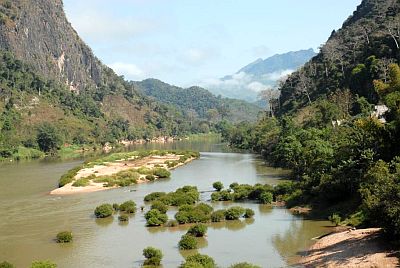
Laos is a
mountainous country, it is covered with forests and is home to several parks and protected areas. In general, the climate becomes milder with increasing altitude, but it also becomes more rainy, in fact, the first pre-monsoon showers are more frequent than in the plains, and there are definitely abundant rains in the monsoon period. At high altitudes, it can get cold even during the day in the winter months, especially in the north.
The highest peak in Laos is
Phou Bia, 2,819 meters (9,249 feet) high.
The period from
March to May, before the rains, is
the hottest of the year, and it is still dry, but with some thunderstorms in the afternoon. April is the hottest month, with average highs about 35 °C (95 °F), but with peaks of 40/42 °C (104/108 °F) all over the country, at least at low altitude. In May, the temperature begins to decrease in the south, while in the north, where the monsoon arrives later, it's still very hot, especially in the first part.
The summer months are less hot, with highs around 30/32 °C (86/90 °F), but with higher humidity.
The climate in detail
The north
During the winter, in the north,
nights are cool even at low altitudes, and it can sometimes get cold. In January 2016, it even snowed in the northern provinces above 900 meters (2,600 feet).
Summer is, on the other hand, hot, muggy and rainy like in the rest of Laos, at least at low altitude.
In the far north, the amount of sunshine is not very good, in fact, the sky is quite often
cloudy even in the dry season. In winter, there's often dull weather and there can be some
drizzle.
Xam Neua
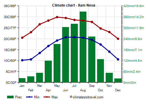
In
Xam Neua (or Samneua), in the north-east, at 970 meters (3,180 ft) above sea level, the average temperature ranges from 15 °C (59 °F) in January to 25 °C (77 °F) in June.
On average, 1,900 mm (75 in) of rain falls per year, of which more than 200 mm (8 in) from May to September.
Luang Prabang
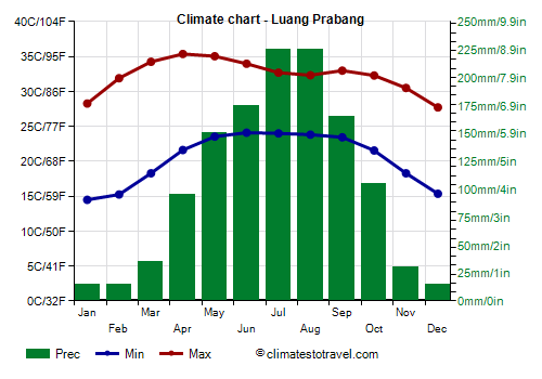
In Luang Prabang (or Louangphabang), located in the north at 300 meters (1,000 feet) above sea level, in
winter, from December to February, lows are around 14.5/15 °C (58/59 °F), but can sometimes drop to 10 °C (50 °F) or below.
Fog often forms at night.
During the day, however, the temperatures are high, in fact, they are around 28 °C (82 °F) in December and January, while they reach 32 °C (89 °F) as early as in February. During the day, it can sometimes get hot even in winter.
Cold spells, in which the temperature remains low even during the day, are very rare, however, in January 2016, there were two days with a high of 9 °C (48 °F), while at night the minimum dropped to 5 °C (41 °F).
Before the monsoon, from March to May, the temperature can reach 40/42 °C (104/107.5 °F), but sometimes it can get very hot even in the monsoon period, when the weather is fine.
In Luang Prabang, 1,250 mm (49 in) of rain fall per year, so we are in one of the least rainy areas of Laos.
In Luang Prabang, winter is quite sunny, more than in the far north. However, sometimes there can be cloudy skies and some drizzle here as well. During the period of the summer monsoon, cloudiness prevails as in the rest of the country, although the sun can sometimes come out.
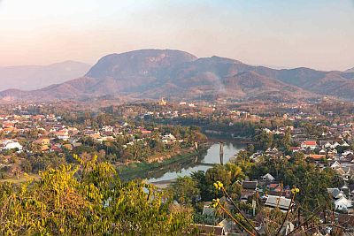
The center
In the
center (see Vientiane, Savannakhet), the winter temperatures are slightly higher, and cold air outbreaks are less frequent and less intense.
Vientiane
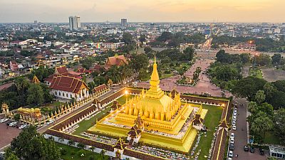
In the capital,
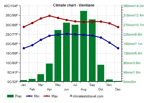
Vientiane, located at 175 meters (575 feet) above sea level on the banks of the Mekong, beyond which is Thailand, the winter is warm to hot, in fact, the average temperature in December and January is 23.3 °C (73.9 °F).
However, sometimes the night temperature can drop to 10/12 °C (50/54 °F) or even less. The coldest record is 6 °C (42.8 °F) and was set in December 1973, while in December 1999, the temperature dropped to 7 °C (44.5 °F). Generally, during the day the temperature exceeds 20 °C (68 °F) even in these cool periods, however, in January 2016, there were two days with a maximum of 15 °C (59 °F).
In Vientiane too,
the hottest period is from March to May, before the monsoon, when the temperature can reach 40 °C (104 °F).
In Vientiane, 1,600 mm (63 in) of rain fall per year; the rains are abundant from May to September, while they are rare from November to March.
In the center, the sun frequently shines in the dry season, from November to April, while the wettest period, from June to September, is the cloudiest. Vientiane receives 2,355 hours of sunshine per year.
The south
Pakse
 Pakse
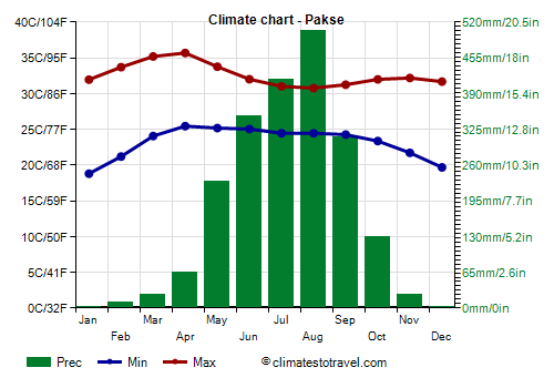
Pakse is the second largest city in the country, and is located in the south, at an altitude of 100 metres (330 feet), also on the banks of the Mekong.
The winter is even warmer, actually, it's quite hot, in fact, highs are normally around 32 °C (90 °F) even in December and January. In coolest periods, the temperature only drops to 12/13 °C (53/55 °F) at night and 25 °C (77 °F) during the day.
The rains in Pakse are abundant, since they amount to 2,000 mm (80 in) per year; from June to September, they even exceed 300 mm (12 in) per month. However, here too, it rains very rarely from November to March.
In the dry period, the sun in Pakse shines even more often than in Vientiane and in the center of the country.
Typhoons
Laos can be reached by
typhoons, the tropical cyclones of South-east Asia, which come from the South China Sea, and affect more directly the coast of Vietnam, though they can bring wind and heavy rainfall also in Laos. Typically, typhoons affect Laos from May 20 to December 15; the north is hit more often than the south.
More rarely, the north-west may be affected by the
remains of cyclones coming from the Bay of Bengal, which may also pass from the second half of April onwards, as happened with Typhoon Nargis in early May 2008.
Tropical cyclones, as well as waves of bad weather brought by the monsoon, can cause flooding, for example the overflowing of the great river that runs through the country from north to south, the Mekong.
When to go
The best time to visit Laos is from
November to February, since it is the coolest part of the dry season.
In November, however, typhoons or tropical storms may still affect the country, and sometimes even in the first half of December. In February, the temperature usually begins to rise and can exceed 35 °C (95 °F).
Consequently, the absolute best time is
from mid-December to late January, though it can sometimes get hot even in January, but the humidity is not high and nights remain cool. It is worth while to recall that, in winter, it can get cold at night across the country, in fact, the minimum temperature can drop below 10 °C (50 °F), but especially in the north, where it can drop in some cases to as low as the freezing point.
In March and April, and also in May until the arrival of the monsoon, it's uncomfortably hot in the lowlands, while the heat it's more bearable in the mountains. However, the weather is still good, although there may be some showers and thunderstorms in the afternoon.
During the rainy season, from May to September, the heat is sweltering, at least in the lowlands; the sky is often cloudy, and torrential rainfall can sometimes make travelling difficult; in the brief periods of good weather, which last a few days, the heat returns to be intense.
What to pack
In
winter: in the north (see Luang Prabang), bring light clothes for the day, a jacket and a sweater for the evening, and a raincoat for the drizzle; in the northern cities above 1,000 meters (3,300 feet), bring spring/autumn clothes, a warm jacket and a sweater for the evening.
For the south-central plains (Vientiane, Savannakhet, Pakse), bring light clothing, a light sweatshirt for the evening, and possibly a light jacket or a sweater for cooler evenings. For the highest peaks, warm clothes, such as a down jacket, a hat, and gloves.
In
summer: all over the country, at low altitude, bring lightweight clothing of natural fibers, a light raincoat or umbrella, and a light sweatshirt for the evening. Above 1,000 meters (3,300 feet), you can add a sweatshirt and a light jacket. For the highest peaks, warm clothes, such as a sweater, a raincoat, and hiking shoes.
Before entering pagodas, it is customary to remove shoes, dress neatly and cover a little.
Climate data - Laos
| Luang Prabang (300 meters) |
|---|
|
| Jan | Feb | Mar | Apr | May | Jun | Jul | Aug | Sep | Oct | Nov | Dec |
|---|
| Min temp. | 14 | 15 | 18 | 22 | 24 | 24 | 24 | 24 | 23 | 22 | 18 | 15 |
|---|
| Max temp. | 28 | 32 | 34 | 35 | 35 | 34 | 33 | 32 | 33 | 32 | 30 | 28 |
|---|
| Precip. | 15 | 15 | 35 | 95 | 150 | 175 | 225 | 225 | 165 | 105 | 30 | 15 |
|---|
| Prec. days | 1 | 3 | 4 | 9 | 15 | 15 | 19 | 20 | 14 | 9 | 4 | 1 |
|---|
|
|
| Sun hours | 6 | 7 | 6 | 6 | 6 | 4 | 4 | 4 | 6 | 6 | 6 | 6 |
|---|
|
| Muang Xay (650 meters) |
|---|
|
| Jan | Feb | Mar | Apr | May | Jun | Jul | Aug | Sep | Oct | Nov | Dec |
|---|
| Min temp. | 11 | 11 | 14 | 18 | 21 | 22 | 22 | 22 | 21 | 18 | 15 | 12 |
|---|
| Max temp. | 26 | 28 | 31 | 32 | 32 | 31 | 30 | 30 | 30 | 29 | 28 | 25 |
|---|
| Precip. | 5 | 20 | 50 | 80 | 240 | 340 | 545 | 565 | 315 | 105 | 15 | 5 |
|---|
| Prec. days | 1 | 2 | 5 | 8 | 15 | 20 | 24 | 25 | 19 | 9 | 3 | 1 |
|---|
|
|
| Sun hours | 8 | 8 | 7 | 7 | 6 | 5 | 4 | 4 | 5 | 7 | 8 | 8 |
|---|
|
| Pakse |
|---|
|
| Jan | Feb | Mar | Apr | May | Jun | Jul | Aug | Sep | Oct | Nov | Dec |
|---|
| Min temp. | 19 | 21 | 24 | 25 | 25 | 25 | 24 | 24 | 24 | 23 | 22 | 20 |
|---|
| Max temp. | 32 | 34 | 35 | 36 | 34 | 32 | 31 | 31 | 31 | 32 | 32 | 32 |
|---|
| Precip. | 0 | 10 | 25 | 65 | 230 | 350 | 415 | 505 | 310 | 130 | 25 | 0 |
|---|
| Prec. days | 0 | 1 | 3 | 8 | 17 | 21 | 24 | 25 | 20 | 12 | 5 | 1 |
|---|
|
|
| Sun hours | 9 | 9 | 8 | 8 | 7 | 5 | 5 | 4 | 5 | 6 | 8 | 8 |
|---|
|
| Sainyabuli (290 meters) |
|---|
|
| Jan | Feb | Mar | Apr | May | Jun | Jul | Aug | Sep | Oct | Nov | Dec |
|---|
| Min temp. | 15 | 15 | 18 | 22 | 24 | 24 | 24 | 24 | 24 | 22 | 19 | 16 |
|---|
| Max temp. | 28 | 30 | 33 | 34 | 33 | 32 | 31 | 31 | 31 | 31 | 29 | 28 |
|---|
| Precip. | 15 | 10 | 45 | 110 | 175 | 150 | 220 | 260 | 250 | 90 | 30 | 20 |
|---|
| Prec. days | 2 | 2 | 5 | 10 | 15 | 16 | 19 | 21 | 18 | 9 | 4 | 2 |
|---|
|
|
| Sun hours | 6 | 7 | 6 | 6 | 6 | 4 | 3 | 3 | 5 | 5 | 6 | 6 |
|---|
|
| Salavan |
|---|
|
| Jan | Feb | Mar | Apr | May | Jun | Jul | Aug | Sep | Oct | Nov | Dec |
|---|
| Min temp. | 17 | 19 | 23 | 24 | 25 | 25 | 24 | 24 | 24 | 23 | 21 | 18 |
|---|
| Max temp. | 31 | 33 | 35 | 35 | 34 | 32 | 30 | 30 | 31 | 31 | 31 | 30 |
|---|
| Precip. | 5 | 15 | 35 | 80 | 215 | 320 | 480 | 460 | 380 | 125 | 25 | 5 |
|---|
| Prec. days | 1 | 1 | 4 | 7 | 16 | 19 | 23 | 24 | 20 | 11 | 4 | 1 |
|---|
|
|
| Sun hours | 9 | 9 | 7 | 7 | 6 | 4 | 4 | 4 | 5 | 6 | 7 | 8 |
|---|
|
| Savannakhet |
|---|
|
| Jan | Feb | Mar | Apr | May | Jun | Jul | Aug | Sep | Oct | Nov | Dec |
|---|
| Min temp. | 16 | 18 | 22 | 24 | 25 | 25 | 25 | 25 | 24 | 22 | 20 | 16 |
|---|
| Max temp. | 30 | 32 | 34 | 35 | 34 | 33 | 32 | 31 | 32 | 31 | 31 | 29 |
|---|
| Precip. | 0 | 25 | 40 | 100 | 215 | 225 | 275 | 325 | 250 | 120 | 15 | 0 |
|---|
| Prec. days | 3 | 5 | 4 | 8 | 18 | 18 | 21 | 21 | 20 | 12 | 4 | 2 |
|---|
|
|
|
|
| Thakhek |
|---|
|
| Jan | Feb | Mar | Apr | May | Jun | Jul | Aug | Sep | Oct | Nov | Dec |
|---|
| Min temp. | 16 | 18 | 22 | 24 | 25 | 25 | 25 | 24 | 24 | 22 | 20 | 17 |
|---|
| Max temp. | 29 | 31 | 34 | 35 | 34 | 32 | 31 | 31 | 31 | 32 | 31 | 29 |
|---|
| Precip. | 5 | 20 | 50 | 80 | 240 | 340 | 545 | 565 | 315 | 105 | 15 | 5 |
|---|
| Prec. days | 1 | 2 | 5 | 8 | 15 | 20 | 24 | 25 | 19 | 9 | 3 | 1 |
|---|
|
|
| Sun hours | 8 | 8 | 7 | 7 | 6 | 5 | 4 | 4 | 5 | 7 | 8 | 8 |
|---|
|
| Vientiane |
|---|
|
| Jan | Feb | Mar | Apr | May | Jun | Jul | Aug | Sep | Oct | Nov | Dec |
|---|
| Min temp. | 18 | 19 | 22 | 24 | 25 | 25 | 25 | 25 | 24 | 23 | 21 | 18 |
|---|
| Max temp. | 29 | 31 | 33 | 35 | 34 | 33 | 32 | 31 | 32 | 32 | 31 | 29 |
|---|
| Precip. | 10 | 15 | 35 | 85 | 245 | 280 | 270 | 335 | 295 | 80 | 10 | 5 |
|---|
| Prec. days | 1 | 2 | 4 | 8 | 15 | 18 | 20 | 21 | 17 | 9 | 2 | 1 |
|---|
|
|
| Sun hours | 8 | 8 | 7 | 8 | 6 | 5 | 4 | 4 | 6 | 7 | 8 | 8 |
|---|
|
| Xam Neua (970 meters) |
|---|
|
| Jan | Feb | Mar | Apr | May | Jun | Jul | Aug | Sep | Oct | Nov | Dec |
|---|
| Min temp. | 10 | 11 | 14 | 17 | 19 | 21 | 21 | 20 | 20 | 17 | 14 | 11 |
|---|
| Max temp. | 20 | 23 | 27 | 28 | 30 | 30 | 29 | 28 | 28 | 25 | 23 | 20 |
|---|
| Precip. | 25 | 30 | 50 | 120 | 210 | 305 | 320 | 390 | 250 | 125 | 55 | 20 |
|---|
| Prec. days | 8 | 8 | 10 | 13 | 17 | 20 | 22 | 24 | 18 | 12 | 7 | 5 |
|---|
|
|
|
|
See also the
temperatures month by month