Select units of measurement for the temperature and rainfall tables (metric or imperial).
Average weather, temperature, rainfall, sunshine
In Burma (or Myanmar), the climate is generally
tropical, with a rainy season from mid-May to October due to the southwest monsoon, a cool and dry season from November to mid-February, and a hot pre-monsoon season from mid-February to the beginning or the middle of May.
In addition, there are
mountainous areas, with a mild or cool climate, but also a portion of the Himalayan range in the far north, which is very cold, at least at high altitude.
The
rains in the monsoon season are plentiful along the coast, and are usually abundant on the mountain slopes, while in the interior, the monsoon penetrates with more difficulty, so much so that some inland valleys and plains are almost arid.
The
sun in Burma shines regularly in the dry season, while in the rainy season it is rarely seen.
The climate in detail
The seasons
Winter, from mid-November to mid-February, is relatively cool in the center-north, while it is hot in the south. The weather is mostly sunny and warm in the daytime, but sometimes,
cool air masses from China may lower the night temperatures to around 5 °C (41 °F) in the northernmost part of the plain, to 8/10 °C (46/50 °F) in the center-north, to 10/12 °C (50/54 °F) in Yangon, and to 12/13 °C (54/55 °F) along the west coast.
In winter, the biggest differences are recorded: the average daily temperature in January is 18.5 °C (65 °F) in Myitkyina, 22.5 °C (72.5 °F) in Mandalay, 21.5 °C (71 °F) in Sittwe, which is located on the northern coast (overlooking the Bay of Bengal), 25 °C (77 °F) in Yangon, and 27 °C (80.5 °F) along the southern part of the coast (see the Mergui islands). So, winter is hot and summer-like only from the area of Yangon (or Rangoon), the former capital, and the beaches of Chaungtha and Ngwesaung.
In the
pre-monsoon period, from mid-February to the beginning or the middle of May, the weather remains sunny, but the temperature gradually rises, and in mountainous areas, there can be some atmospheric instability in the afternoon, with the first thunderstorms. It's the
hottest time of the year throughout Burma, especially in valleys and inland plains, where the heat becomes unbearable, and locals eagerly await for the arrival of the monsoon. The temperature can reach 37/38 °C (99/100 °F) along the southern coast, 40 °C (104 °F) in Yangon, and up to 43/45 °C in Mandalay and inland areas. Typically, April is the hottest month, in addition to the first part of May, before the monsoon comes.
On the coasts (both the the north coast overlooking the Bay of Bengal and the south coast overlooking the Andaman Sea), it doesn't get that hot in the pre-monsoon season, both because of the thermal inertia of the sea and because the monsoon rains arrive earlier.
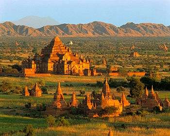
The
monsoon season is less hot: the maximum temperature drops to around 29/30 °C (84/86 °F) on the coasts, to 30 °C (86 °F) in Yangon, and to 34/35 °C (93/95 °F) in Mandalay, but the heat is sultry and the sky is often cloudy. The monsoon arrives first on the southernmost coast of the Andaman Sea (see Tavoy, Kampong Ulu, Mergui Islands), around May 10-15, and it is very intense from the beginning, so much so that more than 400 millimeters (16 inches) of rain fall in this month. In Yangon, the monsoon arrives between May 20-25, in Mandalay (where, however, its effects are more limited) between May 25 and June 1, and finally, it arrives in the far north between the first and the 10th of June.
The rainiest months are almost everywhere
June, July and August, and on the two coasts, being exposed to the west, the rains are plentiful; in fact, some areas receive more than 1,200 mm (47 in) of rain in a month! Yangon is a bit less rainy because it's located in the area of the mouths of the Irrawaddy River, which are exposed to the south, and receives about 500/600 mm (20/23.5 in) of rain per month during this period, while the central area where Mandalay is located receives only 100/150 mm (4/6 in) of rain per month.
In
September, rainfall decreases a bit, except in the extreme south, while during the month of
October, the monsoon withdraws, starting from the north; the monsoon is replaced by drier and gradually cooler winds, which blow from the north or northeast.
As mentioned, the monsoon particularly affects the
coasts, which are exposed to the southwest winds. So, this is the wettest area of Burma, so much so that the amount of rainfall reaches 5,000 mm (195 in) in a year (or rather, in the rainy season, since in the rest of the year, the rains are very poor or absent here as well).
By contrast, in the
central plains, precipitation drops below 900 mm (35.5 in) per year, as happens in Mandalay, Myngyan, Magway, and Bagan, the ancient capital of many Burmese kingdoms.
At the foot of the
mountains and on the slopes, the monsoon rains are instead plentiful, and during the wettest periods, there may be landslides and floods.
The mountains
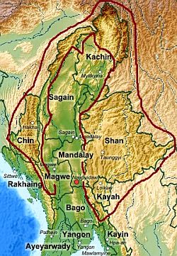
In the far north, we find a mountainous area, which is an offshoot of the Himalayas, where there are perennial snows above 4,500 meters (15,000 ft). The highest mountain is
Hkakabo Razi, 5,881 meters (19,295 feet) high. On the southern side, at the foot of the mountains, the rains are abundant, in fact, they exceed 3,000 millimeters (118 inches) per year. However, there are heavy rainfalls from May to October, while the rest of the year is dry.
More to the south, to the west and the east of the plain, we find
two mountain ranges (the Arakan Mountains and the Shan Plateau), which have a mild climate. In the monsoon season, the rains are abundant in the western range, at times torrential, while they are moderate in the eastern range, around 1,500 mm (60 in) per year. In winter, nights are cold.
Hakha
In
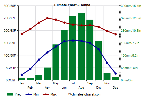
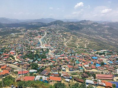
Hakha, the capital of Chin state, located in the west, at 1,865 meters (6,120 ft) above sea level, in the Arakan Mountains, the average temperature ranges from 10.5 °C (51 °F) in January to 19.5 °C (67 °F) in June. In winter, the temperature can drop to -5 °C (23 °F) on the coldest nights.
In Hakha, 1,825 mm (72 in) of rain fall per year, of which more than 150 mm (6 in) per month from May to October.
Taunggyi
In
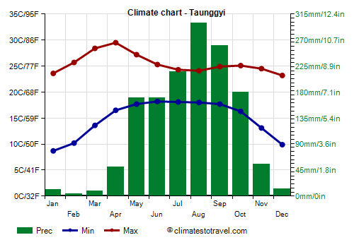
Taunggyi, the capital of the Shan state, located in the eastern range, at 1,400 meters (4,600 feet) above sea level, in winter, it gets cold at night. The coldest record is 3 °C (37.4 °F) and was set in December 2010. From March to May, before the monsoon, the temperature can reach 33/34 °C (91/93 °F).
In Taunggyii, 1,500 mm (60 in) of rain fall per year, with a rainy season from May to October, and a dry season from November to April.
Inland areas
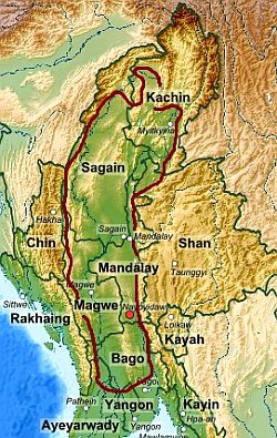
In the inland plain, the climate is tropical in the central-southern part, and subtropical in the northernmost part. In the monsoon season, the rains are heavy but not exceptional.
Myitkyina
In
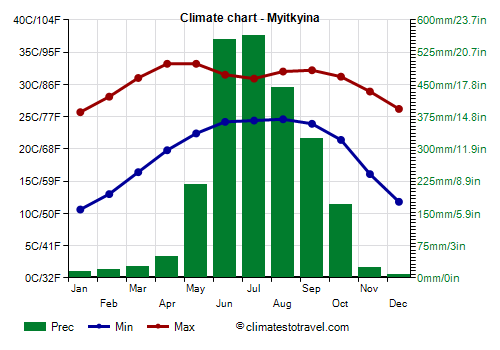
Myitkyina, located in the north, in the Kachin State, winter is quite cool, at least at night, when it can get cold sometimes. The record is 3 °C (37.4 °F) and was set in January 1976 and in December 1983.
In addition, on average, the period from March to May is not as hot as in the center-south, although the temperature can at times reach 38-40 °C (100-104 °F). The temperature reached 42 °C (107.5 °F) in May 1979 and 41 °C (106 °F) in May 2020.
In Myitkyina, rainfall amounts to 2,100 mm (83 in) per year. The rains are very abundant from June to August.
Mandalay
The central part (see Mandalay, Chauk, Bagan) is quite sheltered from the monsoon, so it is
almost barren, with rainfall from 600 to 900 mm (23.5 to 35 in). Furthermore, this area is warmer than the north in winter and becomes
very hot in the pre-monsoon season.
In
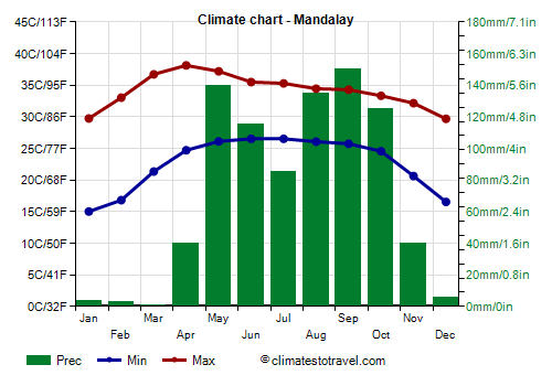
Mandalay, the second largest city in the country, located on the banks of the Irrawaddy River, from December to February the temperature can drop to 10/12 °C (50/54 °F). The coldest record is 7.6 °C (45.7 °F), set in December 1999.
Before the monsoon, from March to May, the temperature generally reaches 40/42 °C (104/107.5 °F). The highest record is 45 °C (113 °F) and was set in May 2010.
Precipitation amounts to only 850 mm (33 in) per year.
In the Mandalay area, where the monsoon penetrates with more difficulty, even in the rainy season, the sun shines on average for a few hours a day.
Naypyidaw
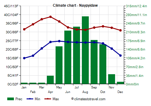
The new capital,
Naypyidaw (or Pyinmana), is located halfway between Mandalay and Yangon. Here, the temperatures are similar to those of Mandalay, although they are a bit higher in winter, while they decrease more in summer and drop to 32 °C (90 °F), since the monsoon has greater effects.
Rainfall amounts to 1,300 mm (51 in) per year.
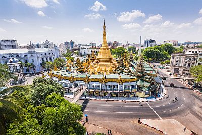
The coast
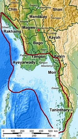
Along the coasts of Burma, the climate is warm all year round, though in the northern part, overlooking the Bay of Bengal, from December to February, nights are cool. In the period preceding the monsoon, from March to May, the temperature rises, though less than in inland areas. As mentioned, the summer rains are definitely heavy.
Sittwe
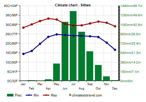
In
Sittwe (formerly Akyab), located in the northern part of the coast, in the Rakhine State, on the coldest nights, the temperature generally drops to 10/12 °C (50/54 °F). In January 2022, it dropped to 7.5 °C (45.5 °F). Even in these cases, however, it reaches 24/25 °C (75/77 °F) during the day.
Precipitation is very abundant, 4,750 mm (187 in) per year. From June to August, up to one meter (3.3 feet) of rain falls per month.
Along the northern coast of Burma, the sea is warm enough to swim in all year round, in fact, it doesn't drop below 25 °C (77 °F) in January and February. In winter, however, as mentioned, the coast of the Bay of Bengal can sometimes be affected by cool air masses, which can lower a bit the air temperature.
Yangon
More to the south, the former capital
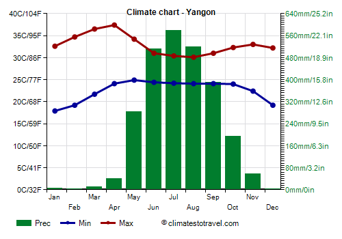
Yangon (Rangoon) is not exactly on the coast, but is located about 40 km (25 miles) away from the coast, in a plain that can become really hot in the period before the monsoon. From March to May, the temperature can reach 40 °C (104 °F).
In Yangon, the rains brought by the monsoon are abundant (although not as abundant as on the coast directly exposed to the west), in fact, they exceed 500 mm (20 in) per month from June to August. Consequentially, the dry season from November to April is sunny, while the sun rarely shines from June to September.
Near Yangon, in the Gulf of Martaban, the sea is warm all year round.
Mergui Islands
In the southern part of the coast, in the Tanintharyi region, it's hot even in winter. Here, we find the Mergui Islands (or Pashu).
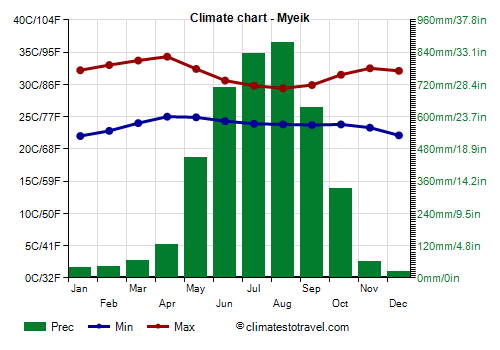
In Myeik (formerly Mergui), the largest city in the area, night temperatures exceed 22 °C (71.5 °F) even in January.
In the southernmost part of the coast, the rains are abundant; moreover, the rainy season is a little longer, and a few abundant downpours occur already in April.
In the southern coast, overlooking the Andaman Sea, the sea in winter is warmer than in the northern part, in fact, the water temperature doesn't drop below 28 °C (82 °F), so it's pleasantly warm all year round.

To the north of the Andaman Islands, belonging to India, we find the
Coco Islands, a small archipelago where the climate is similar to that of the Mergui islands.
Tropical cyclones
Burma can be hit by
tropical cyclones, usually from mid-April to early December. In general, they are most intense both at the beginning and the end of the period, that is, in May-June and October-November.
Those that are formed in the Indian Ocean are called
cyclones. They could hit the coasts of Burma directly from the south-west are more dangerous, although they generally follow a more northern trajectory, directly affecting Bangladesh. The area most at risk is the coastal one, which includes Yangon and the Irrawaddy Delta, as we saw in May 2008 with the terrible cyclone Nargis.
The ones that are formed in the Pacific Ocean and come from the east are called
typhoons. Before reaching Burma, they lose most of the energy over the countries most directly exposed, mainly Vietnam, therefore, they are less dangerous for Burma.
When to go
The best time to visit Burma is winter, and in particular, from
mid-December to mid-February: the weather is dry and sunny, and the risk of cyclones should have ceased. It's hot in Yangon and along the southern coast, while it can get cool at night or even cold in inland areas.
By the second half of February, and even more in March and April, it's definitely hot, but along the coast, you can enjoy the breeze and you can still swim and sunbathe, since the weather stays good.
If you want to travel in summer, in the rainy season, for example in July and August, you will prefer the central plains (see Mandalay, Myngyan, Magway) because they are more sheltered from the monsoon. In contrast, in summer, the coasts are definitely inadvisable because they receive heavy rains.
What to pack
In
winter: in the north (see Myitkyina, Mandalay), and in cities located at middle or low-mountain altitudes (Hakha, Taunggyi, Kengtung), bring spring/autumn clothes (light for the day), a jacket and a sweater for the evening, and a hat and a scarf for cooler evenings. Along the coast, bring light clothing, a light sweatshirt for the evening, and a scarf for the breeze; in the northern part of the coast, up to Yangon, you can add a light jacket or a sweater for cooler evenings. In the Himalayas, bring mountain clothing, and hiking boots.
In summer, bring lightweight clothing of natural fibers, a light raincoat or umbrella, and comfortable shoes. You can add a light sweater for the evening at low-mountain altitudes; in the Himalayas, bring warm clothes, a raincoat, and hiking boots.
Before entering pagodas, it is customary to take off shoes, dress neatly and cover a little.
It's better for women to avoid shorts and miniskirts.
Climate data - Burma
| Hakha (1,865 meters) |
|---|
|
| Jan | Feb | Mar | Apr | May | Jun | Jul | Aug | Sep | Oct | Nov | Dec |
|---|
| Min temp. | 2 | 4 | 8 | 11 | 14 | 16 | 16 | 16 | 15 | 12 | 7 | 3 |
|---|
| Max temp. | 19 | 21 | 23 | 25 | 24 | 23 | 22 | 22 | 22 | 22 | 20 | 18 |
|---|
| Precip. | 10 | 10 | 25 | 65 | 185 | 260 | 335 | 350 | 315 | 205 | 40 | 15 |
|---|
| Prec. days | 1 | 2 | 3 | 7 | 14 | 20 | 24 | 23 | 21 | 16 | 4 | 1 |
|---|
|
|
|
|
| Mandalay |
|---|
|
| Jan | Feb | Mar | Apr | May | Jun | Jul | Aug | Sep | Oct | Nov | Dec |
|---|
| Min temp. | 15 | 17 | 21 | 25 | 26 | 27 | 27 | 26 | 26 | 25 | 21 | 17 |
|---|
| Max temp. | 30 | 33 | 37 | 38 | 37 | 36 | 35 | 34 | 34 | 33 | 32 | 30 |
|---|
| Precip. | 5 | 5 | 0 | 40 | 140 | 115 | 85 | 135 | 150 | 125 | 40 | 5 |
|---|
| Prec. days | 0 | 0 | 0 | 3 | 8 | 7 | 6 | 9 | 8 | 7 | 3 | 1 |
|---|
|
|
| Sun hours | 10 | 10 | 10 | 10 | 9 | 7 | 6 | 5 | 7 | 7 | 9 | 9 |
|---|
|
| Myeik |
|---|
|
| Jan | Feb | Mar | Apr | May | Jun | Jul | Aug | Sep | Oct | Nov | Dec |
|---|
| Min temp. | 22 | 23 | 24 | 25 | 25 | 24 | 24 | 24 | 24 | 24 | 23 | 22 |
|---|
| Max temp. | 32 | 33 | 34 | 34 | 32 | 31 | 30 | 29 | 30 | 32 | 32 | 32 |
|---|
| Precip. | 40 | 45 | 65 | 125 | 450 | 705 | 835 | 875 | 635 | 335 | 60 | 25 |
|---|
| Prec. days | 2 | 3 | 6 | 8 | 21 | 26 | 27 | 27 | 25 | 20 | 6 | 2 |
|---|
|
|
|
| Sea temp | 28 | 28 | 29 | 30 | 30 | 29 | 29 | 29 | 28 | 29 | 29 | 28 |
|---|
| Myitkyina |
|---|
|
| Jan | Feb | Mar | Apr | May | Jun | Jul | Aug | Sep | Oct | Nov | Dec |
|---|
| Min temp. | 11 | 13 | 16 | 20 | 22 | 24 | 24 | 25 | 24 | 21 | 16 | 12 |
|---|
| Max temp. | 26 | 28 | 31 | 33 | 33 | 32 | 31 | 32 | 32 | 31 | 29 | 26 |
|---|
| Precip. | 15 | 20 | 25 | 50 | 215 | 555 | 565 | 440 | 325 | 170 | 25 | 5 |
|---|
| Prec. days | 2 | 3 | 4 | 6 | 14 | 22 | 25 | 21 | 16 | 10 | 2 | 1 |
|---|
|
|
|
|
| Naypyidaw |
|---|
|
| Jan | Feb | Mar | Apr | May | Jun | Jul | Aug | Sep | Oct | Nov | Dec |
|---|
| Min temp. | 15 | 16 | 21 | 24 | 25 | 24 | 24 | 24 | 24 | 24 | 20 | 16 |
|---|
| Max temp. | 32 | 34 | 37 | 39 | 36 | 33 | 32 | 31 | 33 | 33 | 32 | 31 |
|---|
| Precip. | 5 | 5 | 5 | 35 | 150 | 215 | 230 | 275 | 180 | 160 | 40 | 10 |
|---|
| Prec. days | 1 | 0 | 1 | 3 | 10 | 17 | 19 | 21 | 15 | 10 | 2 | 1 |
|---|
|
|
|
|
| Sittwe |
|---|
|
| Jan | Feb | Mar | Apr | May | Jun | Jul | Aug | Sep | Oct | Nov | Dec |
|---|
| Min temp. | 14 | 16 | 20 | 24 | 25 | 24 | 24 | 24 | 24 | 23 | 20 | 17 |
|---|
| Max temp. | 28 | 30 | 32 | 33 | 33 | 30 | 30 | 30 | 31 | 32 | 31 | 29 |
|---|
| Precip. | 10 | 10 | 10 | 25 | 330 | 1130 | 1335 | 940 | 565 | 305 | 85 | 10 |
|---|
| Prec. days | 0 | 0 | 1 | 2 | 12 | 24 | 28 | 27 | 21 | 11 | 3 | 1 |
|---|
|
|
| Sun hours | 9 | 9 | 9 | 8 | 6 | 4 | 3 | 3 | 4 | 6 | 8 | 8 |
|---|
| Sea temp | 25 | 25 | 27 | 29 | 30 | 30 | 29 | 29 | 29 | 29 | 28 | 26 |
|---|
| Taunggyi (1,400 meters) |
|---|
|
| Jan | Feb | Mar | Apr | May | Jun | Jul | Aug | Sep | Oct | Nov | Dec |
|---|
| Min temp. | 9 | 10 | 14 | 16 | 18 | 18 | 18 | 18 | 18 | 16 | 13 | 10 |
|---|
| Max temp. | 24 | 26 | 28 | 30 | 27 | 25 | 24 | 24 | 25 | 25 | 24 | 23 |
|---|
| Precip. | 10 | 5 | 10 | 50 | 170 | 170 | 215 | 300 | 260 | 180 | 55 | 15 |
|---|
| Prec. days | 1 | 0 | 2 | 6 | 15 | 19 | 22 | 24 | 20 | 15 | 5 | 2 |
|---|
|
|
|
|
| Yangon |
|---|
|
| Jan | Feb | Mar | Apr | May | Jun | Jul | Aug | Sep | Oct | Nov | Dec |
|---|
| Min temp. | 18 | 19 | 22 | 24 | 25 | 24 | 24 | 24 | 24 | 24 | 22 | 19 |
|---|
| Max temp. | 33 | 35 | 36 | 37 | 34 | 31 | 30 | 30 | 31 | 32 | 33 | 32 |
|---|
| Precip. | 5 | 0 | 10 | 40 | 285 | 515 | 580 | 520 | 390 | 195 | 55 | 5 |
|---|
| Prec. days | 0 | 0 | 1 | 2 | 14 | 26 | 27 | 26 | 21 | 14 | 3 | 0 |
|---|
|
|
| Sun hours | 10 | 10 | 9 | 10 | 6 | 3 | 2 | 3 | 3 | 7 | 9 | 9 |
|---|
| Sea temp | 27 | 27 | 29 | 30 | 30 | 30 | 29 | 29 | 28 | 29 | 29 | 28 |
|---|
See also the
temperatures month by month