Select units of measurement for the temperature and rainfall tables (metric or imperial).
Average weather, temperature, rainfall, sunshine
In Cambodia, a Southeast Asian country overlooking the Gulf of Thailand, the climate is
tropical, hot all year round, with a
rainy season from May to mid-November due to the south-west monsoon and a
dry season from mid-November to April.
In the dry season, the first part, corresponding to the
winter, is the least hot, and in particular, December is the coolest month of the year. Instead, from mid-February the temperature rises, and the period from mid-February to May, before the monsoon arrives, is
the hottest of the year. The hottest months are April and May, when the heat is oppressive.
In the rainy season, the temperatures are a little cooler, but the higher humidity exacerbates the feeling of sultriness.
The monsoon withdraws in early November in the north and between the middle and the end of the month in the center-south.
The
rains are usually quite abundant, in fact they generally range from 1,300 to 1,800 millimeters (51 to 70 inches) per year in the main cities located in inland areas. The
wettest region of Cambodia is the south-western one, since in the monsoon period the currents come directly from the sea: here, the rainfall exceeds 2,000 mm (78 in) per year, but in the central-northern part, towards the coast of the Gulf of Thailand, it even exceeds 3,000 mm (118 in) and there are vast areas covered with forest.
The climate is a bit cooler in the
highlands, such as the Cardamon Mountains, whose highest point is Phnom Aural, 1,800 meters (5,900 ft) high, and whose slopes are covered by an impenetrable forest and are protected by a nature reserve.
The mountainous areas, in addition to being the coolest, are also the rainiest: they receive up to 5,000 millimeters (197 inches) of rain per year, and may experience some showers in the afternoon even before the monsoon season (ie from February to April).
For swimming, the
sea in Cambodia is warm all year round.
The climate in detail
Inland plains
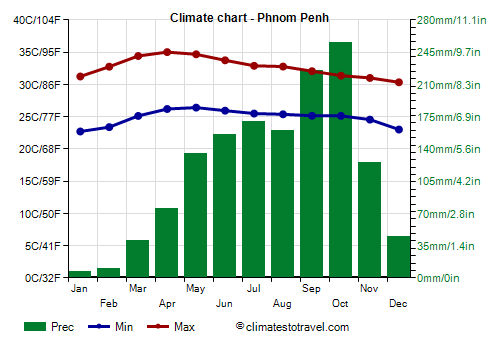
Phnom Penh

In the capital,
Phnom Penh, the daytime temperature is 30 °C (86 °F) in December, it begins to rise slightly already in January, and it reaches its highest values in April, with an average of 35 °C (95 °F), but with peaks of 40 °C (104 °F); then, it decreases slightly during the long rainy months.
In Phnom Penh, 1,400 mm (55 in) of
rain fall per year, with a minimum in January, when it almost never rains, and a maximum in October, when rainfall reaches 250 mm (10 in). The latter part of the monsoon period is therefore the wettest, and presents the greatest risk of flooding, especially in the area crossed by the great river, the Mekong.
The amount of
sunshine in Cambodia is good from December to February, but also in March and April, despite the first thunderstorms, while it's barely sufficient if not low from June to October because of the cloudiness brought by the monsoon. Phnom Penh gets 2,500 hours of sunshine per year.

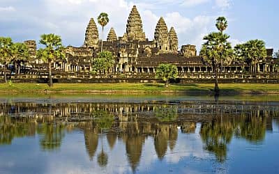
The climate of the ancient capital,
Angkor Wat, located in the northwest of the country, is similar to that of Phnom Penh. However, lying in the northern part, the monsoon in Angkor Wat retreats a bit sooner (i.e. in early November), in addition, the winter temperature is slightly lower.
Coast
Along the
coast, because of the thermal inertia of the sea, in the pre-monsoon season, it does not get as hot as in the interior.
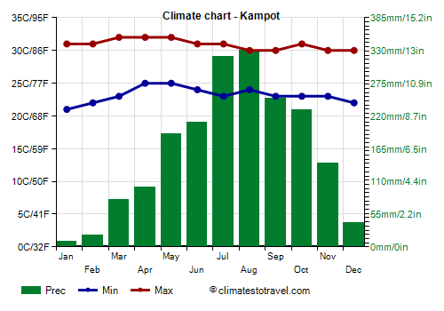
Kampot

For example, in
Krong Kampot, which is located in the south, near the border with Vietnam, in the hottest period, from March to May, the maximum temperatures reach 32 °C (90 °F).
As mentioned, the rains are more abundant on the coast, in fact, they amount to almost 2,000 mm (80 in) per year. In addition, the rainiest months here are July and August, when the rainfall exceeds 300 mm (12 in) per month.
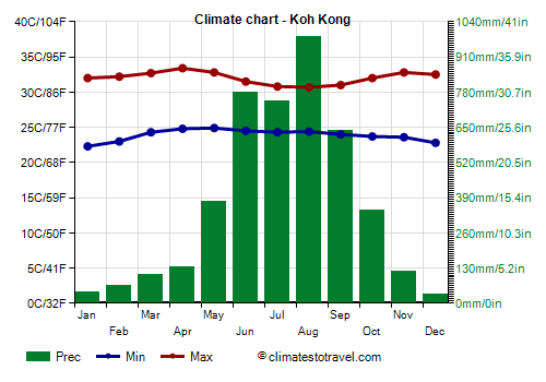
Koh Kong

Further north, on the island of Koh Kong, near the border with Thailand, temperatures are similar.
As mentioned, the northern part of the coast, being exposed to the west, is particularly rainy, in fact, it receives more than 4,000 mm (157 in) of rain per year. In particular, the rains are very abundant and occur almost daily from June to September.
Typhoons
Cambodia can be hit by
typhoons, the tropical cyclones of the western Pacific, though they are quite rare because they usually pass to the north and hit Northern Vietnam and Laos. Moreover, when typhoons affect Cambodia, they are generally weakened because they have released the bulk of their energy over the coasts of Southern Vietnam. However, they can still bring heavy rains, which can cause flooding. In theory, typhoons can occur between June and December, but in Cambodia, they generally pass from mid-October to mid-November, with a maximum at the beginning of November.
When to go
The best time to visit Cambodia goes
from December to mid-February, in fact, it is the coolest, the driest and the sunniest of the year. If you want, you can avoid the first half of December, during which a typhoon has sometimes still affected the country.
The best time for a beach holiday in Cambodia is from December to February, even though, on the coast, the increase in temperature in the period from March to May is not as noticeable as in the interior.
What to pack
All year round, bring
lightweight clothing of natural fibers, comfortable shoes, a scarf for the breeze on the coast. From December to March, you can add a sweatshirt for the evening, and in the rainy season, a light sweatshirt and a light raincoat or umbrella. For the mountains, pack spring/autumn clothes, a raincoat or umbrella, and a sweater and a jacket for the evening, a bit warmer from December to March.
When visiting
temples, it is customary to remove shoes, dress neatly and cover a little.
Climate data - Cambodia
| Kampot |
|---|
|
| Jan | Feb | Mar | Apr | May | Jun | Jul | Aug | Sep | Oct | Nov | Dec |
|---|
| Min temp. | 21 | 22 | 23 | 25 | 25 | 24 | 23 | 24 | 23 | 23 | 23 | 22 |
|---|
| Max temp. | 31 | 31 | 32 | 32 | 32 | 31 | 31 | 30 | 30 | 31 | 30 | 30 |
|---|
| Precip. | 10 | 20 | 80 | 100 | 190 | 210 | 320 | 330 | 250 | 230 | 140 | 40 |
|---|
| Prec. days | 1 | 2 | 5 | 5 | 5 | 12 | 16 | 16 | 12 | 12 | 9 | 3 |
|---|
|
|
|
| Sea temp | 28 | 28 | 29 | 30 | 31 | 30 | 29 | 29 | 29 | 29 | 29 | 28 |
|---|
| Koh Kong |
|---|
|
| Jan | Feb | Mar | Apr | May | Jun | Jul | Aug | Sep | Oct | Nov | Dec |
|---|
| Min temp. | 22 | 23 | 24 | 25 | 25 | 24 | 24 | 24 | 24 | 24 | 24 | 23 |
|---|
| Max temp. | 32 | 32 | 33 | 33 | 33 | 32 | 31 | 31 | 31 | 32 | 33 | 32 |
|---|
| Precip. | 40 | 65 | 105 | 135 | 375 | 780 | 745 | 985 | 640 | 345 | 120 | 35 |
|---|
| Prec. days | 4 | 6 | 8 | 11 | 20 | 24 | 24 | 26 | 23 | 19 | 10 | 4 |
|---|
|
|
|
| Sea temp | 28 | 28 | 29 | 30 | 30 | 30 | 30 | 29 | 29 | 29 | 29 | 28 |
|---|
| Phnom Penh |
|---|
|
| Jan | Feb | Mar | Apr | May | Jun | Jul | Aug | Sep | Oct | Nov | Dec |
|---|
| Min temp. | 23 | 23 | 25 | 26 | 26 | 26 | 25 | 25 | 25 | 25 | 25 | 23 |
|---|
| Max temp. | 31 | 33 | 34 | 35 | 35 | 34 | 33 | 33 | 32 | 31 | 31 | 30 |
|---|
| Precip. | 5 | 10 | 40 | 75 | 135 | 155 | 170 | 160 | 225 | 255 | 125 | 45 |
|---|
| Prec. days | 1 | 1 | 3 | 6 | 14 | 15 | 16 | 16 | 19 | 17 | 9 | 4 |
|---|
|
|
| Sun hours | 8 | 8 | 9 | 8 | 7 | 6 | 5 | 6 | 4 | 7 | 7 | 8 |
|---|
|
| Siem Reap |
|---|
|
| Jan | Feb | Mar | Apr | May | Jun | Jul | Aug | Sep | Oct | Nov | Dec |
|---|
| Min temp. | 21 | 23 | 25 | 26 | 26 | 26 | 25 | 25 | 25 | 25 | 24 | 22 |
|---|
| Max temp. | 31 | 33 | 34 | 35 | 35 | 33 | 33 | 32 | 31 | 31 | 31 | 30 |
|---|
| Precip. | 5 | 5 | 30 | 55 | 150 | 215 | 195 | 210 | 290 | 200 | 50 | 5 |
|---|
| Prec. days | 2 | 1 | 3 | 8 | 17 | 18 | 18 | 18 | 17 | 15 | 6 | 2 |
|---|
|
|
|
|
| Stung Treng |
|---|
|
| Jan | Feb | Mar | Apr | May | Jun | Jul | Aug | Sep | Oct | Nov | Dec |
|---|
| Min temp. | 20 | 22 | 24 | 26 | 26 | 25 | 25 | 25 | 25 | 24 | 23 | 21 |
|---|
| Max temp. | 32 | 34 | 35 | 36 | 35 | 33 | 32 | 32 | 32 | 32 | 32 | 31 |
|---|
| Precip. | 0 | 10 | 20 | 80 | 200 | 270 | 330 | 300 | 320 | 180 | 60 | 10 |
|---|
|
|
|
|
|
See also the
temperatures month by month