Select units of measurement for the temperature and rainfall tables (metric or imperial).
Average weather, temperature, rainfall, sunshine hours
Index
Introduction
In Andalusia, the southernmost region of Spain, there are
different types of climate: the Mediterranean climate of the coast, which becomes particularly cool and windy in the southern tip (where the east wind reigns supreme), and particularly arid in the east; the Mediterranean climate, though with very hot summers, in the valley of the Guadalquivir; the semi-continental climate in low-mountain areas; and finally, the alpine climate on high mountains.
The region is crossed by two
mountain ranges, the
Sierra Morena to the north and the
Betic Cordillera (which includes the
Sierra Nevada) to the south; between the two, we find the Betic Depression, crossed by the river Guadalquivir and characterized by very hot summers, where there are cities such as Seville and Córdoba.
Some mountain areas are particularly green, and are home to
parks, such as the
Parque Natural de los Alcornocales (within which we find
El Bosque de la Niebla, where the east wind creates a fog that deposits water droplets on the trees, thus creating a particularly humid environment) and the
Parque Natural Sierra de Grazalema, both in the south-west, or the
Parque Natural de las Sierras de Cazorla in the northeast, or the
Parque Nacional de Sierra Nevada, located in the south. In this area, we find the highest peaks of all continental Spain, starting from mount
Mulhacen, 3,478 meters (11,411 feet) high.
Let us now talk about the climate of the major cities.

Atlantic coast
On the
Atlantic coast (called
Costa de la Luz), the climate is Mediterranean, with very mild winters and warm, sunny summers.
Cadiz
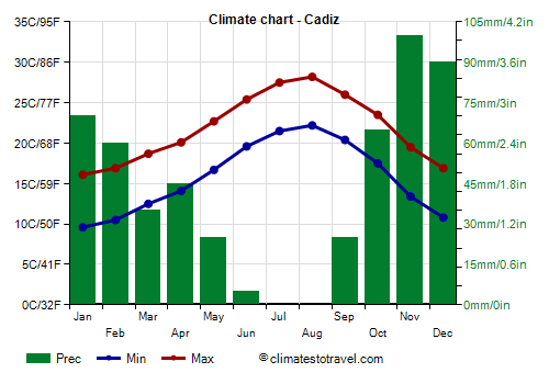
In
Cadiz, the average temperature ranges from 12.5 °C (54.5 °F) in January to 25 °C (77 °F) in July and August. Here are the average temperatures.
Cadiz - Average temperatures (1991-2020) |
| Month | Min | Max | Mean |
|---|
| January | 9.6 | 16.1 | 12.8 |
|---|
| February | 10.5 | 16.9 | 13.7 |
|---|
| March | 12.5 | 18.7 | 15.6 |
|---|
| April | 14.1 | 20.1 | 17.1 |
|---|
| May | 16.7 | 22.7 | 19.7 |
|---|
| June | 19.6 | 25.4 | 22.5 |
|---|
| July | 21.5 | 27.5 | 24.5 |
|---|
| August | 22.2 | 28.2 | 25.2 |
|---|
| September | 20.4 | 26 | 23.2 |
|---|
| October | 17.5 | 23.5 | 20.5 |
|---|
| November | 13.4 | 19.5 | 16.4 |
|---|
| December | 10.8 | 16.9 | 13.8 |
|---|
| Year | 15.8 | 21.8 | 18.75 |
|---|
In a typical year, 525 millimeters (20.5 inches) of rain fall, with a peak in November and December. In summer, as generally happens in Mediterranean climates, there is little or no rain.
Cadiz - Average precipitation| Month | Days |
|---|
| January | 70 | 7 |
|---|
| February | 60 | 6 |
|---|
| March | 35 | 5 |
|---|
| April | 45 | 6 |
|---|
| May | 25 | 3 |
|---|
| June | 5 | 1 |
|---|
| July | 0 | 0 |
|---|
| August | 0 | 0 |
|---|
| September | 25 | 3 |
|---|
| October | 65 | 6 |
|---|
| November | 100 | 7 |
|---|
| December | 90 | 8 |
|---|
| Year | 525 | 52 |
|---|
The amount of
sunshine in Cadiz is great in summer, when clear skies prevail, it is good in spring, especially from mid-April onwards, and it is still decent in autumn and winter, when there is a moderate amount of cloudy days, during periods of bad weather, but there are also sunny periods.
In a year, there are 3,000 hours of sunshine: we are at the highest levels in Europe.
Cadiz - Sunshine hours| Month | Average | Total |
|---|
| January | 6 | 185 |
|---|
| February | 7 | 195 |
|---|
| March | 7.5 | 230 |
|---|
| April | 8.5 | 255 |
|---|
| May | 10 | 305 |
|---|
| June | 11 | 330 |
|---|
| July | 11.5 | 355 |
|---|
| August | 11 | 335 |
|---|
| September | 8.5 | 250 |
|---|
| October | 7.5 | 230 |
|---|
| November | 6 | 185 |
|---|
| December | 5.5 | 165 |
|---|
| Year | 8.3 | 3025 |
|---|
Inland plain
Moving away from the coast, in the valley of the Guadalquivir (or Betic Depression), the summer is much hotter, while the winter is a bit colder, especially at night.
Jerez de la Frontera
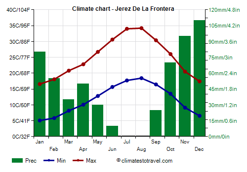
Already in
Jerez de la Frontera, about 15 kilometers (9 miles) north-east of the coast, the climate is slightly colder in winter, especially at night, when light frosts can occasionally occur, while it is warmer in summer, especially during the day, when there are many hot days, with highs about 35/36 °C (95/97 °F), and with peaks of 40/41 °C (104/106 °F). Rainfall amounts to about 565 mm (22.5 in) per year, with a winter maximum and a summer minimum, as usual.
Jerez De La Frontera - Average temperatures (1991-2020) |
| Month | Min | Max | Mean |
|---|
| January | 5.1 | 16.6 | 10.8 |
|---|
| February | 5.8 | 18.1 | 12 |
|---|
| March | 8.2 | 20.8 | 14.5 |
|---|
| April | 10.1 | 22.8 | 16.4 |
|---|
| May | 12.8 | 26.7 | 19.8 |
|---|
| June | 15.7 | 30.6 | 23.1 |
|---|
| July | 17.7 | 34 | 25.9 |
|---|
| August | 18.4 | 34.2 | 26.3 |
|---|
| September | 16.5 | 30.4 | 23.4 |
|---|
| October | 13.5 | 26 | 19.8 |
|---|
| November | 9.1 | 20.5 | 14.8 |
|---|
| December | 6.6 | 17.4 | 12 |
|---|
| Year | 11.7 | 24.9 | 18.25 |
|---|
Northwest of Jerez de la Frontera lies the
Doñana National Park, rich in biodiversity, which is home to vast sand dunes near the coast.
Seville
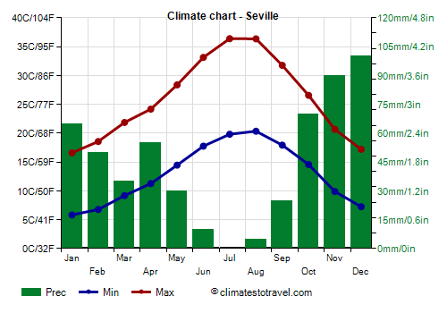
Continuing to the north-east, in
Seville, 70 km (45 miles) away from the coast, the summer is even hotter, in fact, highs in July and August are normally about 36 °C (97 °F): in summer, this area is the hottest in Europe, and the temperature can sometimes reach 45 °C (113 °F).
Seville - Average temperatures (1991-2020) |
| Month | Min | Max | Mean |
|---|
| January | 5.8 | 16.6 | 11.2 |
|---|
| February | 6.8 | 18.6 | 12.7 |
|---|
| March | 9.2 | 21.9 | 15.5 |
|---|
| April | 11.3 | 24.2 | 17.7 |
|---|
| May | 14.5 | 28.4 | 21.4 |
|---|
| June | 17.8 | 33.1 | 25.4 |
|---|
| July | 19.8 | 36.4 | 28.1 |
|---|
| August | 20.3 | 36.4 | 28.4 |
|---|
| September | 17.9 | 31.8 | 24.8 |
|---|
| October | 14.6 | 26.6 | 20.6 |
|---|
| November | 9.9 | 20.7 | 15.3 |
|---|
| December | 7.2 | 17.2 | 12.2 |
|---|
| Year | 13 | 26 | 19.45 |
|---|
Rainfall amounts to 540 mm (21 in) per year, still with a Mediterranean pattern.
Córdoba
Continuing to the east, in
Córdoba, the temperatures are similar to those of Seville, but owing to the longer distance from the sea, it can sometimes be a little colder in winter, while in summer, it can be slightly hotter.

Mediterranean coast
The Mediterranean coast has a cooler and more humid climate in the western part, while in summer, it becomes progressively more arid and hot as you proceed towards the east.
Precipitation along the Mediterranean coast varies significantly, becoming progressively scarcer towards the east, although the pattern is the same, with a maximum in the cold half of the year, especially between November and January, and a minimum in summer, when it almost never rains.
In fact, rainfall amounts to 835 millimeters (33 inches) per year in Algeciras, where it can sometimes be abundant from November to March, while it drops to 585 mm (23 in) in Marbella, to 525 mm (20.5 in) in Malaga, and to 450 mm (17.5 in) in Nerja. The easternmost part is definitely arid, almost desert, in fact, precipitation in Almería amounts to just 200 mm (8 in) per year.
The coast overlooking the Mediterranean Sea can be divided according to the province and to the name that have been given to the different parts for tourism purposes:
- The westernmost part, in the
province of Cadiz, overlooking the Strait of Gibraltar, is also the southernmost, but despite this, it's the coolest in summer. This happens both because of the influence of the ocean and because of the prevalence of the
east wind ("levante").
Tarifa

The coolest area corresponds precisely to the southern tip of Spain, at the point that separates the Atlantic Ocean from the Mediterranean Sea (see
Tarifa). In this strait, you can spot dolphins and whales.
Tarifa - Average temperatures (1991-2020) |
| Month | Min | Max | Mean |
|---|
| January | 10.3 | 15.3 | 12.8 |
|---|
| February | 10.4 | 15.4 | 12.9 |
|---|
| March | 12 | 16.6 | 14.3 |
|---|
| April | 12.9 | 17.8 | 15.4 |
|---|
| May | 15 | 20.1 | 17.6 |
|---|
| June | 17.7 | 22.7 | 20.2 |
|---|
| July | 19.4 | 24.7 | 22 |
|---|
| August | 20.2 | 25.4 | 22.8 |
|---|
| September | 18.9 | 23.7 | 21.3 |
|---|
| October | 16.7 | 21.3 | 19 |
|---|
| November | 13.3 | 18.2 | 15.8 |
|---|
| December | 11.5 | 16.2 | 13.8 |
|---|
| Year | 14.9 | 19.8 | 17.3 |
|---|
A little further to the north-east, there's the Bay of Gibraltar: in the western part, we find the city of Algeciras, in the eastern one, we find La Linea de la Concepcion, and just to the south we find
Gibraltar, which belongs to Great Britain, and has a cool and humid microclimate.
Malaga
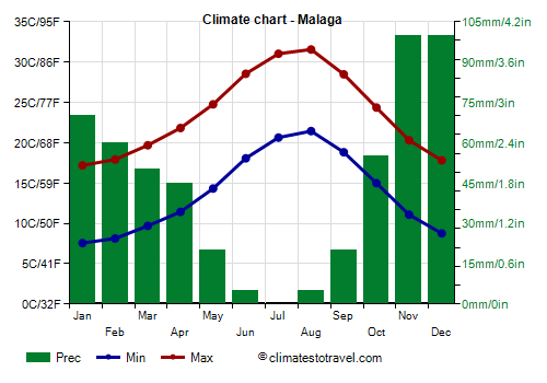
- The central part, called
Costa del Sol, corresponds to the coast of the
province of Málaga. Here, the temperatures are quite similar to that of the Costa de la Luz, Mediterranean-like: summers are hot but not too much, although there can be some very hot days, with highs of 35 °C (95 °F) and more.
In
Málaga, daytime temperatures in July and August are 31/31.5 °C (88/89 °F), therefore much higher than in Tarifa.
Malaga - Average temperatures (1991-2020) |
| Month | Min | Max | Mean |
|---|
| January | 7.6 | 17.2 | 12.4 |
|---|
| February | 8.1 | 17.9 | 13 |
|---|
| March | 9.7 | 19.7 | 14.7 |
|---|
| April | 11.4 | 21.8 | 16.6 |
|---|
| May | 14.3 | 24.8 | 19.6 |
|---|
| June | 18.1 | 28.6 | 23.3 |
|---|
| July | 20.6 | 31 | 25.8 |
|---|
| August | 21.4 | 31.6 | 26.5 |
|---|
| September | 18.8 | 28.5 | 23.7 |
|---|
| October | 15 | 24.4 | 19.7 |
|---|
| November | 11.1 | 20.3 | 15.7 |
|---|
| December | 8.8 | 17.8 | 13.3 |
|---|
| Year | 13.8 | 23.7 | 18.7 |
|---|
- The eastern part of the coast is divided between the
province of Granada, where it's called
Costa Tropical (or Costa de Granada) and the
province of Almería, where it's called
Costa de Almería. Here, the temperatures are similar, while proceeding towards the east, the rainfall decreases, and at the same time the temperature of the sea gradually increases (see below).
Almería
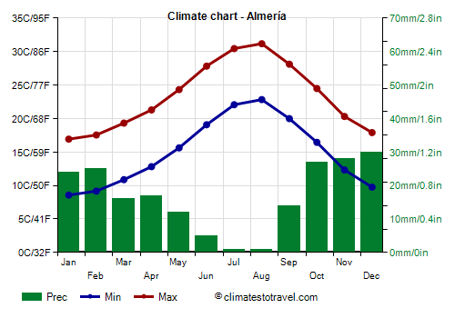
In
Almería, average precipitation is at semi-desert levels.
Almeria - Average precipitation| Month | Days |
|---|
| January | 24 | 3 |
|---|
| February | 25 | 3 |
|---|
| March | 16 | 3 |
|---|
| April | 17 | 3 |
|---|
| May | 12 | 2 |
|---|
| June | 5 | 0 |
|---|
| July | 1 | 0 |
|---|
| August | 1 | 0 |
|---|
| September | 14 | 2 |
|---|
| October | 27 | 3 |
|---|
| November | 28 | 4 |
|---|
| December | 30 | 3 |
|---|
| Year | 200 | 25 |
|---|
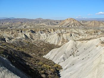
North of Almería there is a desert, the
Tabernas Desert (
Desierto de Tabernas), where many western movies were filmed. However, the southeastern coastal area, from Almería to Cabo de Gata, and from San José to Playa de los Muertos, is semi-desert as well: the cape of Gata is probably the driest place in Europe, since it receives only 155 mm (6.1 in) of rain per year. Here, we find the
Cabo de Gata-Nijar Natural Park.
Hilly and mountainous areas
As mentioned, in Andalusia, there are several mountain ranges, therefore, there are also cities located at more or less high elevation. The most important one,
Granada, is situated at 700 meters (2,300 feet) above sea level, and it's often cold on winter nights, while in summer, the heat is often intense during the day, while nights remain usually cool.
Jaén
In
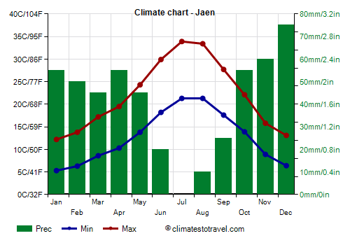
Jaén, located at an altitude a bit lower, 500 meters (1,600 feet) above sea level, winter is mild enough (despite some cold days), while summer is hot (with several scorching days).
Jaen - Average temperatures (1991-2020) |
| Month | Min | Max | Mean |
|---|
| January | 5.3 | 12.2 | 8.8 |
|---|
| February | 6.3 | 13.8 | 10 |
|---|
| March | 8.6 | 17.2 | 12.9 |
|---|
| April | 10.3 | 19.5 | 14.9 |
|---|
| May | 13.8 | 24.3 | 19 |
|---|
| June | 18.2 | 29.9 | 24 |
|---|
| July | 21.3 | 33.9 | 27.6 |
|---|
| August | 21.3 | 33.4 | 27.4 |
|---|
| September | 17.6 | 27.7 | 22.6 |
|---|
| October | 13.9 | 22.1 | 18 |
|---|
| November | 8.9 | 15.8 | 12.4 |
|---|
| December | 6.4 | 13.1 | 9.8 |
|---|
| Year | 12.7 | 22 | 17.3 |
|---|
Precipitation amounts to 500 mm (20 in) per year, with a maximum in December of 80 mm (3.1 in), and a minimum in July of 2 mm (0.08 in).
Jaen - Average precipitation| Month | Days |
|---|
| January | 55 | 6 |
|---|
| February | 50 | 6 |
|---|
| March | 45 | 5 |
|---|
| April | 55 | 7 |
|---|
| May | 45 | 6 |
|---|
| June | 20 | 2 |
|---|
| July | 0 | 0 |
|---|
| August | 10 | 1 |
|---|
| September | 25 | 3 |
|---|
| October | 55 | 6 |
|---|
| November | 60 | 7 |
|---|
| December | 75 | 8 |
|---|
| Year | 495 | 56 |
|---|
At higher altitudes, the temperature drops further, but the maximum temperatures in summer are high, about 29/31 °C (84/88 °F), still at about 1,000/1,200 meters (3,300/3,900 feet).
Sea temperature
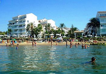
The sea temperature along the
Atlantic coast (
Costa de la Luz) remains cool even in summer, and reaches a maximum of 22/22.5 °C (71.5/72.5 °F) in August and September.
Cadiz - Sea temperature| Month |
|---|
| January | 16.5 |
|---|
| February | 16 |
|---|
| March | 16 |
|---|
| April | 17 |
|---|
| May | 18 |
|---|
| June | 20 |
|---|
| July | 22 |
|---|
| August | 22.5 |
|---|
| September | 22 |
|---|
| October | 20.5 |
|---|
| November | 19"> |
|---|
| December | 17.5 |
|---|
| Year | 18.9 |
|---|
On the
Mediterranean coast (
Costa del Sol), the sea is not very warm as well, especially in the western part, because of the infiltration of Atlantic waters, however, in summer, it is slightly warmer than on the Atlantic coast. In Malaga, the water temperature reaches 22/23 °C (71.5/73.5 °F) from July to September.
Malaga - Sea temperature| Month |
|---|
| January | 16 |
|---|
| February | 15 |
|---|
| March | 15 |
|---|
| April | 16 |
|---|
| May | 17 |
|---|
| June | 20 |
|---|
| July | 22 |
|---|
| August | 23 |
|---|
| September | 22 |
|---|
| October | 20 |
|---|
| November | 18"> |
|---|
| December | 16 |
|---|
| Year | 18.4 |
|---|
Continuing to the east, and moving away from the Atlantic, the sea becomes gradually warmer in summer: in Almería, the sea temperature reaches 24 °C (75 °F) in August and 23 °C (73 °F) in September. In the easternmost part, where the coast is facing southeast, the sea is even warmer, so much so that in Mojacar, it reaches 25 °C (77 °F) in August.
Mojacar - Sea temperature| Month |
|---|
| January | 15 |
|---|
| February | 15 |
|---|
| March | 15 |
|---|
| April | 16 |
|---|
| May | 18 |
|---|
| June | 20 |
|---|
| July | 23 |
|---|
| August | 25 |
|---|
| September | 24 |
|---|
| October | 21 |
|---|
| November | 18"> |
|---|
| December | 16 |
|---|
| Year | 18.9 |
|---|
Best Time
In order to avoid the summer heat, the best periods to visit Andalusia, if the trip includes the plain of the Guadalquivir and cities such as Seville and Córdoba (and also Granada), are
spring and autumn, for example April, May and October, although in these months, it can sometimes rain. Those who can stand the heat can choose the summer, a season when the weather is often scorchingly hot, but it's more pleasant in high mountain areas.
In
winter, you can find several pleasant days in the plains, sunny and spring-like, although it can get cold at night in the interior, and waves of bad weather cannot be excluded. In this season, you can go skiing in the Sierra Nevada, and maybe you can take a trip to the sea, where you will usually find mild weather (though not warm: we are still in the Mediterranean winter), with several sunny days, and possible but not abundant rain (since that is the arid part of the coast).
On the other hand, the best time for a beach holiday is the
summer, from June to mid-September. It's better to bring a sweatshirt for cool and windy evenings, especially in June and September, in particular, in the Costa de la Luz and in the province of Cadiz, but for safety even in July and August, especially if you are sensitive to cold.
Back to topSee also the
temperatures by month.