Average weather, temperature, rainfall, sunshine hours
Index
Introduction
The Costa de la Luz ("Coast of Light"), Spain's southwestern coast, overlooking the Atlantic Ocean, has beautiful beaches, hotels and golf courses, and areas that lend themselves to surfing and diving. Here, the
climate is Mediterranean, with mild, relatively rainy winters and warm, sunny summers. However, there are some differences that are worth considering: the western part is hot in summer, with highs around 30 °C (86 °F) in July and August, and a greater likelihood of hot days, while the eastern part, and especially the south-eastern tip, overlooking the Straits of Gibraltar, is mild and windy.
In winter, very cold days on the Costa de la Luz are rare, though cold periods, with minimum temperatures dropping to 0 °C (32 °F), can sometimes occur.
Huelva Province
Let's start from the west. In the westernmost part, the mouth of the Guadiana River, which marks the border with Portugal (where we find the region of Algarve, see
Faro), is divided into different branches, among which we find some islands: Isla Canela, Isla del Moral, and Isla Cristina. Further to the east, we find the towns of La Antilla and Islantilla. More to the east, in the area of the mouth of the Rio Piedras, we find the coastal towns of El Rompido and El Portil.

Huelva

We are in the province of
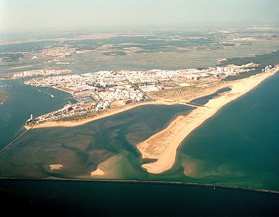
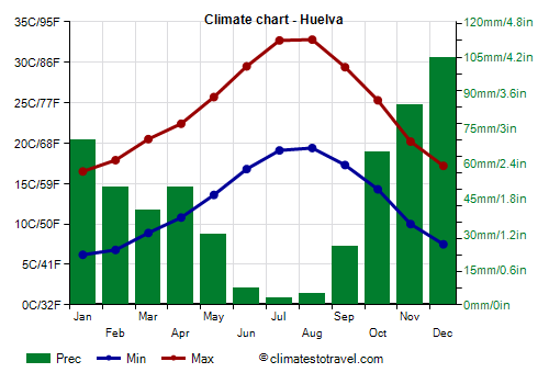
Huelva: the capital is located more to the east, near the confluence of the Tinto and Odiel rivers, a short distance from the coast (on the coast near Huelva, we find Punta Umbría). Here, the daily average temperature ranges from 11.5 °C (52.5 °F) in January to 26 °C (79 °F) in July and August. In Huelva, in summer the daytime temperatures are already 2/3 degrees Celsius higher than on the coast, and at times, it can be very hot (though more rarely than in the interior of Andalusia), with highs around 38/40 °C (100/104 °F).
Rainfall in Huelva is not abundant, since it amounts to 530 millimeters (21 inches) per year, and follows the Mediterranean pattern, in fact, most of it falls from October to April, while in summer, it almost never rains. The rainiest month is December, with 105 mm (4.1 in).
In Huelva, the amount of
sunshine is very good in summer, when clear skies prevail, but all in all, it is decent even in winter, when bad weather alternates with sunny periods. With nearly 3,000 hours of sunshine per year, we are at the highest level in Europe.
Continuing to the east, around the beach resort of Matalascañas, we find the
Doñana National Park, a UNESCO World Heritage Site, rich in biodiversity, with many species of birds that find refuge in the numerous lagoons. On the coast facing south-west, there are large beaches with sand dunes.
The temperature of the
sea in the western part of the Costa de la Luz remains very cool even in summer, since the waters of the Atlantic never warm up by much, and reach 21.5 °C (70.5 °F) in July, 22.5 °C (72.5 °F) in August and 22 °C (71.5 °F) in September.
While on the coast the summer temperatures remain typically acceptable because of the sea breeze, in the
interior we find a particularly hot region, the Guadalquivir river valley, which, in summer, is the hottest area in Europe (see
Seville,
Cordoba).
Cádiz Province
Beyond the mouth of the Guadalquivir river, we enter the
province of Cádiz, where summer tends to become oddly less warm as you head south. Here, we find places like Chipiona and Rota, where there's an airport.
Rota

In
Rota, the summer temperature is still quite high, with highs of 30/30.5 °C (86/87 °F) in July and August, compared to the western part of the coast and in Huelva, very hot days are less frequent. On the other hand, there can sometimes be quite cool days because of the east wind (
levante), with highs around 24/26 °C (75/79 °F) even in July and August. This wind in Rota is intermittent and only blows at certain times, but becomes more frequent and intense as you head southeast.
Southeast of Rota, there are a number of cities very close to each other, but separated by bays and river branches: El Puerto de Santa María, Cádiz, located in the bay of the same name, the nearby cities of Puerto Real and San Fernando (the latter is an island, although it was artificially connected to the mainland), and finally, Chiclana de la Frontera. The beaches in this part of the coast are Playa de la Barrosa and Playa de Sancti Petri.
Cadiz

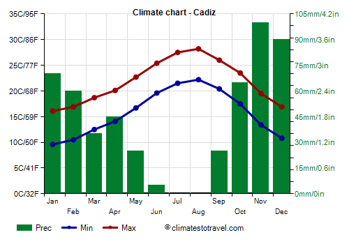
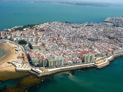
Being surrounded by the sea, the city of
Cadiz tends to be mild, in fact the maximum temperatures in August do not go above 28 °C (82.5 °F). In summer, the east wind can blow here as well, causing some pretty cool periods.

Continuing along the coast towards the south-east, we find towns like Roche, Conil de la Frontera, El Palmar, Zahora, and Cape Trafalgar, beyond which we find Barbate.
Tarifa

Starting from this area, we enter the region of the Strait of
Gibraltar, which in summer is particularly subject to the cool
Levante wind, and thus, has a particularly mild and windy microclimate, even cool in the southern tip, where we find
Tarifa, and where the maximum temperatures in August are just 25.5 °C (78 °F).
The temperature of the
sea in the Cádiz province is similar to that of the Huelva province, and remains cool even in summer, however, it's slightly warmer, and reaches 22/23 °C (72/73 °F) from July to September.
Best Time
The
best period to visit the cities of the Costa de la Luz, and for walks and excursions, corresponds to the months of April, May, and October, especially if you plan an excursion to the interior of Andalusia, which is often scorchingly hot in summer.
For a beach holiday, the best time is instead the summer, from June to mid-September. It is advisable to bring a sweatshirt for cool and windy evenings, especially in June and September, but for safety, also in July and August, especially in the eastern part, that is, in the Cádiz province.
Back to
Andalusia.
Back to top