Select units of measurement for the temperature and rainfall tables (metric or imperial).
Average weather, temperature, rainfall, sunshine hours
Lazio is a region of central Italy, facing the Tyrrhenian Sea to the west and crossed by the central Apennines to the east, and has a mild climate,
Mediterranean on the coast, and gradually more continental and colder as as you proceed eastward and climb in altitude.
In the cold semester,
periods of bad weather due to humid currents of Atlantic or Mediterranean origin, in which the mild sirocco and libeccio winds blow and there may be rain and thunderstorms, alternate with periods of good weather, in which it can get cold at night but the days are mild and sunny. The wind from the north, the
tramontana, brings cold but sunny days to the lowland areas, while it can snow in the Apennines.
In summer,
high pressure of subtropical or African origin generally prevails; in the afternoon, thunderstorms can break out in the Apennines, which can sometimes reach the plains.
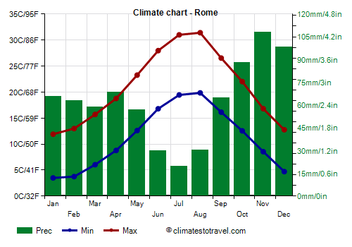
Precipitation is scarcer in the north-western part, on the border with Tuscany (Maremma), where it amounts to 600 millimeters (23.5 inches) per year, it is at an intermediate level in Rome (800 mm or 31.5 in), while it is abundant in the southeast, south of the Alban Hills and in Frosinone (1,200 mm or 47 in).
The rainiest season is generally autumn, when there can be
abundant rains, which can cause the overflowing of rivers, such as the Tiber and the Aniene. This can happen in October and November, but sometimes also in December, which often takes on autumnal characteristics, especially in the first part.
Lazio is a
sunny region, especially on the coast and in the vicinity, where there are over 2,500 hours of sunshine a year.
Plains and hills
On the coast and in the plains located nearby (see Rome, Latina), the climate is
Mediterranean, with mild, rainy winters, and hot, sunny summers.
The
coast is the mildest area.
To the south we find the small archipelago of the Pontine Islands (see
Ponza), which have a particularly mild climate. Even the promontories on the coast, where the influence of the sea is greater (see
Santa Marinella, Gaeta), have a very mild climate, in fact the average temperature in January is around 10 °C (50 °F).

In
Rome, located in a plain, the Agro Romano, about 20 km (12 mi) from the sea, the climate is slightly milder in the districts closest to the sea, which receive the sea breeze more easily in the summer afternoons. In the north and east, thunderstorms are more likely to develop in the afternoon, while the center suffers from the city's heat island and is therefore hotter.
At Ciampino airport, south-east of the city, the average temperature ranges from 7.5 °C (46 °F) in January to 25.5 °C (78 °F) in August. Here are the average temperatures.
Rome - Average temperatures (1991-2020) |
| Month | Min | Max | Mean |
|---|
| January | 3.5 | 11.9 | 7.7 |
|---|
| February | 3.8 | 13 | 8.4 |
|---|
| March | 6 | 15.7 | 10.9 |
|---|
| April | 8.8 | 18.8 | 13.8 |
|---|
| May | 12.6 | 23.3 | 17.9 |
|---|
| June | 16.8 | 28 | 22.4 |
|---|
| July | 19.4 | 31 | 25.2 |
|---|
| August | 19.8 | 31.4 | 25.6 |
|---|
| September | 16.1 | 26.5 | 21.3 |
|---|
| October | 12.6 | 22 | 17.3 |
|---|
| November | 8.6 | 16.8 | 12.7 |
|---|
| December | 4.7 | 12.8 | 8.7 |
|---|
| Year | 11.1 | 21 | 16 |
|---|

Moving further away from the coast, and rising slightly in altitude, the climate becomes slightly more continental (see
Viterbo,
Rieti,
Frosinone), and can be defined as
transitional Mediterranean.
During
cold spells, which are becoming rarer due to global warming, the temperature can drop to -2/-3 °C (27/28 °F) on the coast, and down to -5/-6 °C (21/23 °F) or below in inland areas. In January 1985, during an exceptionally cold wave, it snowed throughout the region, and temperatures dropped to -20 °C (-4 °F) in inland areas.
Snow in the plains and hills of Lazio is rare, especially at low altitudes, because the region receives the influence of the Tyrrhenian Sea, while the Apennines protect it from cold winds.
In summer there can be
heat waves, which are becoming more frequent, during which the temperature can reach 35-37 °C (95-99 °F) along the coasts and 40 °C (104 °F) in inland areas.
In summer, a particularly hot area is north of Rome, along the A1 motorway (see Orte, Magliano Sabina, Fiano Romano), where it is often 2-3 degrees Celsius hotter than in the already hot city of Rome.
On the Lazio coast (see Civitavecchia, Ladispoli, Nettuno, San Felice Circeo, Gaeta), the
sea is warm enough for swimming from July to September, while it is still a little cool in June. Here is the average sea temperature in Ostia, near Rome.
Ostia - Sea temperature| Month |
|---|
| January | 15 |
|---|
| February | 14 |
|---|
| March | 14 |
|---|
| April | 15 |
|---|
| May | 18 |
|---|
| June | 22 |
|---|
| July | 25 |
|---|
| August | 26 |
|---|
| September | 24 |
|---|
| October | 21 |
|---|
| November | 19"> |
|---|
| December | 16 |
|---|
| Year | 19.1 |
|---|
Mountains
In
mountainous areas the climate naturally becomes colder. In winter, there can be heavy snowfalls, while in summer, thunderstorms can break out in the afternoon.
The highest peak in Lazio is
Monte Gorzano, 2,458 meters (8,064 ft) high, belonging to the Monti della Laga and located in the north-eastern part, on the border with Abruzzo.
In this area, we find a plateau at an altitude of 900-1,000 meters (2,950-3,300 ft), where there are towns such as Amatrice and Leonessa.

In
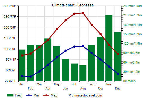
Leonessa, located at an altitude of 965 meters (3,165 ft), the average temperature ranges from 2 °C (35.5 °F) in January to 19 °C (66 °F) in August.
Leonessa - Average temperatures (1992-2016) |
| Month | Min | Max | Mean |
|---|
| January | -2.6 | 6.9 | 2.1 |
|---|
| February | -2.9 | 7.8 | 2.4 |
|---|
| March | -0.5 | 10.9 | 5.2 |
|---|
| April | 2.6 | 14.2 | 8.4 |
|---|
| May | 6 | 19.1 | 12.6 |
|---|
| June | 9.1 | 23.3 | 16.2 |
|---|
| July | 11 | 26.3 | 18.6 |
|---|
| August | 11.2 | 26.7 | 19 |
|---|
| September | 8 | 21.2 | 14.6 |
|---|
| October | 5.1 | 16.9 | 11 |
|---|
| November | 1.7 | 11.8 | 6.7 |
|---|
| December | -1.6 | 7.5 | 2.9 |
|---|
| Year | 4 | 16.1 | 10 |
|---|
The weather station of
Mount Terminillo, the "mountain of the Romans", located south of Leonessa, is at 1,875 meters (6,150 ft), although the summit is at 2,217 meters (7,274 ft). Here, the average temperature ranges from around -1.8 °C (28.8 °F) in February to 15.3 °C (59.5 °F) in August.
Terminillo - Average temperatures (1991-2020) |
| Month | Min | Max | Mean |
|---|
| January | -3.8 | 0.6 | -1.6 |
|---|
| February | -4.1 | 0.6 | -1.8 |
|---|
| March | -2.1 | 2.7 | 0.3 |
|---|
| April | 0.3 | 5.6 | 2.9 |
|---|
| May | 4.5 | 10.5 | 7.5 |
|---|
| June | 8.5 | 14.5 | 11.5 |
|---|
| July | 11.6 | 17.8 | 14.7 |
|---|
| August | 12.2 | 18.5 | 15.3 |
|---|
| September | 7.6 | 13.1 | 10.4 |
|---|
| October | 4.6 | 9.6 | 7.1 |
|---|
| November | 0.5 | 4.8 | 2.6 |
|---|
| December | -2.9 | 1.4 | -0.8 |
|---|
| Year | 3.1 | 8.3 | 5.7 |
|---|
Best Time
For a
beach holiday along the coasts and islands of Lazio, the best period is the summer, particularly in July and August, since they are the hottest and sunniest months, and in which the sea is warmest as well.
To
visit the cities, given that it can be very hot in summer, you can choose the periods from mid-April to mid-June and from September to early October. In June, the weather is often good, but sometimes it can get very hot, especially in the second half of the month.
See also the
temperatures by month.