![]() Climate chart - Fiumicino (Lazio)
Climate chart - Fiumicino (Lazio)
The climate of Fiumicino is
Mediterranean, with mild, rainy winters and hot, sunny summers.
The city is located on the Roman coast, about 25 km (15 mi) away from the center of Rome, and north of the delta of the Tiber, beyond which we find the lido of Ostia. Nearby we find the
Leonardo da Vinci international airport, while on the coast to the north is Focene.
The climate is similar to that of Rome, but there are some small differences.
Winter is a little milder, but during periods of bad weather, the southwest wind, the libeccio, can be stronger. Generally, the temperature does not drop below -5 °C (23 °F) even during the coldest periods. In January 1985, the temperature dropped to -8 °C (17.5 °F), against -10/-11 °C (12/14 °F) at the Rome airports.
Summer is less hot, and afternoon thunderstorms from the Apennines are a little rarer. At the end of June 2022, the heat record was broken with 39 °C (102 °F).

Best Time
The best months for a beach holiday in Ostia and Fiumicino are July and August. In June, the sea is still a little cool.
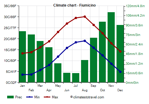
Fiumicino - Climate data
The
average temperature of the coldest month (January) is of 8.5 °C (47.3 °F), that of the warmest month (August) is of 24.6 °C (76.3 °F). Here are the average temperatures.
Fiumicino - Average temperatures (1991-2020) | Month | Min (°C) | Max (°C) | Mean (°C) | Min (°F) | Max (°F) | Mean (°F) |
|---|
| January | 3.6 | 13.3 | 8.5 | 39 | 56 | 47.3 |
|---|
| February | 3.7 | 13.9 | 8.8 | 39 | 57 | 47.8 |
|---|
| March | 5.7 | 16.1 | 10.9 | 42 | 61 | 51.7 |
|---|
| April | 8 | 18.8 | 13.4 | 46 | 66 | 56.2 |
|---|
| May | 11.9 | 23.1 | 17.5 | 53 | 74 | 63.5 |
|---|
| June | 15.8 | 27 | 21.4 | 60 | 81 | 70.5 |
|---|
| July | 18.4 | 29.5 | 24 | 65 | 85 | 75.1 |
|---|
| August | 19.1 | 30.1 | 24.6 | 66 | 86 | 76.3 |
|---|
| September | 15.9 | 26.3 | 21.1 | 61 | 79 | 70 |
|---|
| October | 12.4 | 22.5 | 17.5 | 54 | 73 | 63.5 |
|---|
| November | 8.6 | 17.9 | 13.2 | 47 | 64 | 55.8 |
|---|
| December | 4.9 | 14.2 | 9.6 | 41 | 58 | 49.2 |
|---|
| Year | 10.7 | 21.1 | 15.9 | 51.3 | 70 | 60.5 |
|---|
amounts to 735 millimeters (28.9 inches) per year: so, it is at an intermediate level. It ranges from 15 mm (0.6 in) in the driest months (June, July) to 110 mm (4.3 in) in the wettest one (November). Here is the average precipitation.
Fiumicino - Average precipitation| Month | Millimeters | Inches | Days |
|---|
| January | 80 | 3.1 | 9 |
|---|
| February | 75 | 3 | 8 |
|---|
| March | 65 | 2.6 | 8 |
|---|
| April | 55 | 2.2 | 7 |
|---|
| May | 30 | 1.2 | 4 |
|---|
| June | 15 | 0.6 | 2 |
|---|
| July | 15 | 0.6 | 2 |
|---|
| August | 35 | 1.4 | 3 |
|---|
| September | 70 | 2.8 | 4 |
|---|
| October | 95 | 3.7 | 7 |
|---|
| November | 110 | 4.3 | 10 |
|---|
| December | 90 | 3.5 | 9 |
|---|
| Year | 735 | 28.9 | 73 |
|---|
The
sea temperature ranges from 14 °C (57 °F) in February to 26 °C (79 °F) in August. Here are the average sea temperatures.
Fiumicino - Sea temperature| Month | Celsius (°C) | Fahrenheit (°F) |
|---|
January | 15 | 59 | February | 14 | 58 | March | 14.5 | 58 | April | 15.5 | 60 | May | 18.5 | 65 | June | 22 | 72 | July | 25 | 77 | August | 26 | 79 | September | 24.5 | 76 | October | 21.5 | 71 | November | 19 | 66 | December | 16.5 | 62 | Year | 19.4 | 66.9 |
There are on average around 2705
sunshine hours per year. Here are the average hours of sunshine per day.
Fiumicino - Sunshine hours| Month | Average | Total |
|---|
January | 4.5 | 135 | February | 5 | 145 | March | 6 | 185 | April | 7.5 | 220 | May | 9 | 285 | June | 10.5 | 310 | July | 11.5 | 365 | August | 10.5 | 325 | September | 8.5 | 260 | October | 7 | 215 | November | 5 | 145 | December | 4 | 125 | Year | 7.4 | 2705 |
Fiumicino - Weather by month
Based on the period 1991-2020
January, the coldest month of the year, is generally a quite mild month. The average temperature is of 8.5 °C (47 °F), with a minimum of 3.6 °C (38.5 °F) and a maximum of 13.3 °C (56 °F).

On the coldest nights of the month, the temperature usually drops to around -2 °C (28.5 °F). However, it dropped to -5.3 °C (22.5 °F) in January 2002.

On the warmest days of the month, the temperature usually reaches around 17.5 °C (63.5 °F). However, it reached 22.1 °C (71.8 °F) in January 1996.

Precipitation amounts to 80 mm (3.1 in), distributed over 9 days.
The day lasts on average 9 hours and 30 minutes.

There are on average 4.5 hours of sunshine per day. So, the sun shines 46% of the time.
The average humidity is 75%. Hence, the air is normally humid.
The average wind speed is 13 kph (8 mph).

The average sea temperature is of 15 °C (58.5 °F). Therefore, the sea is cold for swimming.
February is generally a mild month. The average temperature is of 8.8 °C (48 °F), with a minimum of 3.7 °C (38.7 °F) and a maximum of 13.9 °C (57 °F).
On the coldest nights of the month, the temperature usually drops to around -2 °C (29 °F). However, it dropped to -5 °C (23 °F) in February 2018.
On the warmest days of the month, the temperature usually reaches around 18 °C (64.5 °F). However, it reached 22.1 °C (71.8 °F) in February 2019.
Precipitation amounts to 75 mm (3 in), distributed over 8 days.
The day lasts on average 10 hours and 35 minutes.
There are on average 5 hours of sunshine per day. So, the sun shines 48% of the time.
The average humidity is 72%. Hence, the air is normally humid.
The average wind speed is 13 kph (8 mph).
The average sea temperature is of 14 °C (57.5 °F). Therefore, the sea is very cold for swimming.
March is generally a mild month. The average temperature is of 10.9 °C (52 °F), with a minimum of 5.7 °C (42.3 °F) and a maximum of 16.1 °C (61 °F).
On the coldest nights, which normally occur at the beginning of the month, the temperature usually drops to around 0 °C (32.5 °F). However, it dropped to -4.5 °C (23.9 °F) in March 1996.
On the warmest days, which normally occur at the end of the month, the temperature usually reaches around 21 °C (70 °F). However, it reached 26.3 °C (79.3 °F) in March 1991.
Precipitation amounts to 65 mm (2.6 in), distributed over 8 days.
The day lasts on average 12 hours and 0 minutes.
There are on average 6 hours of sunshine per day. So, the sun shines 49% of the time.
The average humidity is 73%. Hence, the air is normally humid.
The average wind speed is 13 kph (8 mph).
The average sea temperature is of 14.5 °C (58 °F). Therefore, the sea is very cold for swimming.
April is generally a mild month. The average temperature is of 13.4 °C (56 °F), with a minimum of 8 °C (46.5 °F) and a maximum of 18.8 °C (65.9 °F).
On the coldest nights, which normally occur at the beginning of the month, the temperature usually drops to around 3 °C (37 °F). However, it dropped to -0.9 °C (30.4 °F) in April 1995.
On the warmest days, which normally occur at the end of the month, the temperature usually reaches around 24 °C (75.5 °F). However, it reached 28.4 °C (83.1 °F) in April 2013.
Precipitation amounts to 55 mm (2.2 in), distributed over 7 days.
The day lasts on average 13 hours and 25 minutes.
There are on average 7.5 hours of sunshine per day. So, the sun shines 54% of the time.
The average humidity is 74%. Hence, the air is normally humid.
The average wind speed is 13 kph (8 mph).
The average sea temperature is of 15.5 °C (60 °F). Therefore, the sea is cold for swimming.
May is generally a very mild month. The average temperature is of 17.5 °C (63 °F), with a minimum of 11.9 °C (53.3 °F) and a maximum of 23.1 °C (73.6 °F).
On the coldest nights, which normally occur at the beginning of the month, the temperature usually drops to around 7 °C (44.5 °F). However, it dropped to 5 °C (41 °F) in May 1991.
On the warmest days, which normally occur at the end of the month, the temperature usually reaches around 28.5 °C (83 °F). However, it reached 33.1 °C (91.6 °F) in May 2008.
Precipitation amounts to 30 mm (1.2 in), distributed over 4 days.
The day lasts on average 14 hours and 35 minutes. So the days are long.
There are on average 9 hours of sunshine per day. So, the sun shines 63% of the time.
The average humidity is 73%. Hence, the air is normally humid.
The average wind speed is 12 kph (7 mph).
The average sea temperature is of 18.5 °C (65.5 °F). Therefore, the sea is very cool for swimming.
June is generally a warm month. The average temperature is of 21.4 °C (71 °F), with a minimum of 15.8 °C (60.5 °F) and a maximum of 27 °C (80.5 °F).
On the coldest nights, which normally occur at the beginning of the month, the temperature usually drops to around 10.5 °C (51 °F). However, it dropped to 8.9 °C (48 °F) in June 2005.
On the warmest days, which normally occur at the end of the month, the temperature usually reaches around 32 °C (90 °F). However, it reached 36.5 °C (97.7 °F) in June 2019.
Precipitation amounts to 15 mm (0.6 in), distributed over 2 days.
The day lasts on average 15 hours and 10 minutes. So the days are long. June 21, the summer solstice, is the longest day of the year in the Northern Hemisphere.
There are on average 10.5 hours of sunshine per day. So, the sun shines 68% of the time.
The average humidity is 70%. Hence, the air is normally humid.
The average wind speed is 12 kph (7 mph).
The average sea temperature is of 22 °C (72 °F). Therefore, the sea is cool for swimming.
July is generally a warm to hot month. The average temperature is of 24.0 °C (75 °F), with a minimum of 18.4 °C (65.1 °F) and a maximum of 29.5 °C (85.1 °F).
On the coldest nights of the month, the temperature usually drops to around 14 °C (57 °F). However, it dropped to 11.9 °C (53.4 °F) in July 2000.
On the warmest days of the month, the temperature usually reaches around 34 °C (93 °F). However, it reached 38.1 °C (100.6 °F) in July 2005.
Precipitation amounts to 15 mm (0.6 in), distributed over 2 days.
The day lasts on average 14 hours and 50 minutes. So the days are long.
There are on average 11.5 hours of sunshine per day. So, the sun shines 79% of the time.
The average humidity is 69%.
The average wind speed is 12 kph (8 mph).
The average sea temperature is of 25 °C (77 °F). Therefore, the sea is warm enough for swimming.
August, the warmest month of the year, is generally a warm to hot, muggy month. The average temperature is of 24.6 °C (76 °F), with a minimum of 19.1 °C (66.3 °F) and a maximum of 30.1 °C (86.2 °F).
On the coldest nights of the month, the temperature usually drops to around 15 °C (59.5 °F). However, it dropped to 13.4 °C (56.1 °F) in August 1998.
On the warmest days of the month, the temperature usually reaches around 34 °C (93.5 °F). However, it reached 37.1 °C (98.8 °F) in August 1998.
Precipitation amounts to 35 mm (1.4 in), distributed over 3 days.
The day lasts on average 13 hours and 50 minutes.
There are on average 10.5 hours of sunshine per day. So, the sun shines 76% of the time.
The average humidity is 70%. Hence, the air is normally humid.
The average wind speed is 12 kph (7 mph).
The average sea temperature is of 26 °C (79 °F). Therefore, the sea is warm enough for swimming.
September is generally a warm month. The average temperature is of 21.1 °C (70 °F), with a minimum of 15.9 °C (60.6 °F) and a maximum of 26.3 °C (79.4 °F).
On the coldest nights, which normally occur at the end of the month, the temperature usually drops to around 10 °C (50 °F). However, it dropped to 8.3 °C (46.9 °F) in September 2007.
On the warmest days, which normally occur at the beginning of the month, the temperature usually reaches around 30.5 °C (86.5 °F). However, it reached 33 °C (91.4 °F) in September 2015.
Precipitation amounts to 70 mm (2.8 in), distributed over 4 days.
The day lasts on average 12 hours and 25 minutes.
There are on average 8.5 hours of sunshine per day. So, the sun shines 69% of the time.
The average humidity is 72%. Hence, the air is normally humid.
The average wind speed is 12 kph (7 mph).
The average sea temperature is of 24.5 °C (75.5 °F). Therefore, the sea is warm enough for swimming.
October is generally a very mild month. The average temperature is of 17.5 °C (63 °F), with a minimum of 12.4 °C (54.4 °F) and a maximum of 22.5 °C (72.6 °F).
On the coldest nights, which normally occur at the end of the month, the temperature usually drops to around 6.5 °C (44 °F). However, it dropped to 2.9 °C (37.2 °F) in October 1994.
On the warmest days, which normally occur at the beginning of the month, the temperature usually reaches around 26.5 °C (79.5 °F). However, it reached 30.4 °C (86.7 °F) in October 1990.
Precipitation amounts to 95 mm (3.7 in), distributed over 7 days.
The day lasts on average 11 hours and 0 minutes.
There are on average 7 hours of sunshine per day. So, the sun shines 63% of the time.
The average humidity is 76%. Hence, the air is normally humid.
The average wind speed is 12 kph (7 mph).
The average sea temperature is of 21.5 °C (71 °F). Therefore, the sea is cool for swimming.
November is generally a mild month. The average temperature is of 13.2 °C (56 °F), with a minimum of 8.6 °C (47.5 °F) and a maximum of 17.9 °C (64.2 °F).
On the coldest nights, which normally occur at the end of the month, the temperature usually drops to around 2 °C (35.5 °F). However, it dropped to -1.4 °C (29.5 °F) in November 1995.
On the warmest days, which normally occur at the beginning of the month, the temperature usually reaches around 23 °C (73 °F). However, it reached 26.5 °C (79.7 °F) in November 1999.
Precipitation amounts to 110 mm (4.3 in), distributed over 10 days.
The day lasts on average 9 hours and 50 minutes.
There are on average 5 hours of sunshine per day. So, the sun shines 49% of the time.
The average humidity is 77%. Hence, the air is normally humid.
The average wind speed is 13 kph (8 mph).
The average sea temperature is of 19 °C (66 °F). Therefore, the sea is very cool for swimming.
December is generally a mild month. The average temperature is of 9.6 °C (49 °F), with a minimum of 4.9 °C (40.9 °F) and a maximum of 14.2 °C (57.6 °F).
On the coldest nights of the month, the temperature usually drops to around -1 °C (30 °F). However, it dropped to -4.7 °C (23.5 °F) in December 1996.
On the warmest days of the month, the temperature usually reaches around 18.5 °C (65.5 °F). However, it reached 20.6 °C (69.1 °F) in December 1993.
Precipitation amounts to 90 mm (3.5 in), distributed over 9 days.
The day lasts on average 9 hours and 10 minutes. December 21, the winter solstice, is the shortest day of the year in the Northern Hemisphere.
There are on average 4 hours of sunshine per day. So, the sun shines 44% of the time.
The average humidity is 75%. Hence, the air is normally humid.
The average wind speed is 13 kph (8 mph).
The average sea temperature is of 16.5 °C (61.5 °F). Therefore, the sea is cold for swimming.