Select units of measurement for the temperature and rainfall tables (metric or imperial).
Average weather, temperature, rainfall, sunshine
In Albania, a small country of the Balkan peninsula overlooking the Adriatic Sea, the climate is
Mediterranean on the coast (with mild, rainy winters and hot, sunny summers), while it's slightly
more continental in the interior, though it's really cold only in mountainous areas.
Rainfall is quite abundant on the coast, where it amounts to about 1,000 millimeters (40 inches) per year, and is even more abundant in hilly and mountainous areas facing west and south, where it can exceed 2,000 mm (78 in) per year. The only sheltered areas, where it does not rain that much, are the inland valleys, such as that of Korçë, where 805 mm (32 in) of rain fall each year on average.
Along the coast and in the plain, the rainfall regime is Mediterranean, with a maximum between autumn and winter and a minimum in summer, when it seldom rains. On the other hand, in mountainous areas, during summer, there can be some thunderstorms in the afternoon.
In Albania, the
sun shines regularly in summer, especially in the plain and along the coast, while in the other seasons, there may be sunny days, but also cloudy and rainy days.
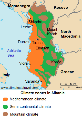
In the following map, we can see the
climate zones in Albania.
Index
Coast and plain
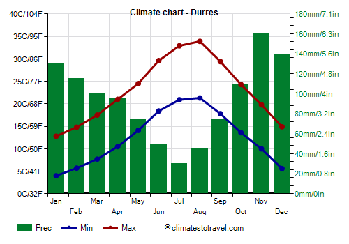
Along the coast (see
Durrës,
Vlorë, Sarandë), the climate is mild, with average temperatures in January of 8/9 °C (46/48 °F), however, during the winter there may be cold waves when the winds blow from Russia. The records are around -9/-10 °C (14/16 °F).
Despite the breeze from the sea, in recent years the summer has become very hot, as air masses of African origin often prevail. During heat waves, the temperature can reach 40 °C (104 °F) even on the coast.
Rainfall amounts to 1,000/1,100 mm (40/44 in) per year, with a maximum between October and April and a minimum in summer.
The temperature of the
sea in Albania is still a little cool for swimming in June, while it becomes acceptable or pleasantly warm from July to September.
Tirana
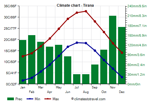
In the capital,
Tirana, which is located about 30 kilometers (20 miles) away from the coast, the climate is similar to that of the coast, although it is a bit colder at night. Winter is mild and rainy, but it can sometimes get cold at night, while summer is hot and sunny, with some very hot days.
In Tirana, 1,300 mm (53 in) of rain fall per year.
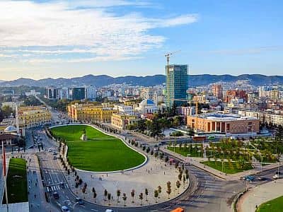
In the cities located around sea level but farther from the sea, or sheltered by mountain ranges (see
Shkodër), the climate is slightly more continental.
Hills and mountains
Moving inland, and with increasing altitude, the climate becomes much colder. Winters are cold and snowy, and summers are cooler.
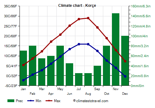
For instance, in
Korçë, located in the east, 900 meters (2,950 feet) above sea level, the average temperature ranges from a low of 1.5 °C (34.5 °F) in January to a high of 22.5 °C (72.5 °F) in August.
The
highest mountains in Albania are in the east, on the border with northern Macedonia, where we find Mount Korab, 2,764 meters (9,068 feet) high, and in the north, where we find the Prokletije (or Albanian Alps), which are part of the Dinaric Alps, and whose highest peak is Maja Jezercë, 2,694 meters (8,838 ft) high.
When to go
The best time to go to the Albanian coast for a
beach holiday is summer: in July and August, the sun shines and the Adriatic Sea is warm.
If you want to
visit the cities at sea level, such as Tirana or Shkodër, considering that they can be hot in summer, you can choose the months of May, June, and September. October has pleasant temperatures too, but it can be quite rainy, especially in the second part.
September, a month when the sea is slightly warmer than in June, may therefore be an interesting choice, to take a trip throughout the country and at the same time to spend some time at the beach.
What to pack in the suitcase
In
winter: bring warm clothes, a coat, and a raincoat or umbrella. In mountainous areas: bring warm clothes, such as a down jacket, a hat, gloves, and a scarf.
In
summer: bring light clothes, and a sweatshirt or sweater for the evening or for the mountains.
Climate data - Albania
| Durres |
|---|
Durres, location on the map |
|---|
| Jan | Feb | Mar | Apr | May | Jun | Jul | Aug | Sep | Oct | Nov | Dec |
|---|
| Min temp. | 4 | 6 | 8 | 10 | 14 | 18 | 21 | 21 | 18 | 14 | 10 | 6 |
|---|
| Max temp. | 13 | 15 | 18 | 21 | 24 | 30 | 33 | 34 | 29 | 24 | 20 | 15 |
|---|
| Precip. | 130 | 115 | 100 | 95 | 75 | 50 | 30 | 45 | 75 | 110 | 160 | 140 |
|---|
| Prec. days | 13 | 12 | 12 | 12 | 9 | 7 | 5 | 5 | 7 | 9 | 13 | 13 |
|---|
|
| Day length | 10 | 11 | 12 | 13 | 14 | 15 | 15 | 14 | 12 | 11 | 10 | 9 |
|---|
| Sun hours | 4 | 5 | 6 | 7 | 9 | 11 | 12 | 10 | 9 | 7 | 5 | 4 |
|---|
| Sea temp | 14 | 14 | 14 | 15 | 18 | 22 | 24 | 25 | 23 | 21 | 18 | 16 |
|---|
| Gjirokaster (200 meters) |
|---|
Gjirokaster, location on the map |
|---|
| Jan | Feb | Mar | Apr | May | Jun | Jul | Aug | Sep | Oct | Nov | Dec |
|---|
| Min temp. | 1 | 4 | 5 | 7 | 11 | 14 | 17 | 17 | 14 | 9 | 6 | 2 |
|---|
| Max temp. | 11 | 14 | 18 | 22 | 25 | 30 | 34 | 35 | 30 | 24 | 18 | 12 |
|---|
| Precip. | 290 | 230 | 190 | 90 | 50 | 40 | 10 | 10 | 60 | 180 | 400 | 320 |
|---|
| Prec. days | 11 | 10 | 8 | 7 | 5 | 2 | 1 | 1 | 3 | 7 | 14 | 12 |
|---|
|
|
|
|
| Korçe (900 meters) |
|---|
Korçe, location on the map |
|---|
| Jan | Feb | Mar | Apr | May | Jun | Jul | Aug | Sep | Oct | Nov | Dec |
|---|
| Min temp. | -2 | 1 | 3 | 6 | 10 | 13 | 16 | 16 | 12 | 8 | 4 | 0 |
|---|
| Max temp. | 5 | 9 | 12 | 17 | 21 | 25 | 28 | 29 | 24 | 19 | 13 | 7 |
|---|
| Precip. | 70 | 80 | 55 | 60 | 80 | 45 | 25 | 25 | 40 | 80 | 145 | 100 |
|---|
| Prec. days | 9 | 8 | 9 | 9 | 10 | 7 | 4 | 3 | 5 | 7 | 11 | 10 |
|---|
|
| Day length | 10 | 11 | 12 | 13 | 14 | 15 | 15 | 14 | 12 | 11 | 10 | 9 |
|---|
| Sun hours | 4 | 5 | 6 | 7 | 8 | 10 | 11 | 10 | 8 | 6 | 5 | 4 |
|---|
|
| Kuçove |
|---|
Kuçove, location on the map |
|---|
| Jan | Feb | Mar | Apr | May | Jun | Jul | Aug | Sep | Oct | Nov | Dec |
|---|
| Min temp. | 1 | 4 | 6 | 8 | 12 | 16 | 18 | 18 | 15 | 11 | 8 | 3 |
|---|
| Max temp. | 14 | 16 | 19 | 22 | 26 | 31 | 34 | 35 | 30 | 25 | 20 | 15 |
|---|
| Precip. | 85 | 80 | 75 | 60 | 90 | 45 | 25 | 25 | 65 | 80 | 90 | 85 |
|---|
| Prec. days | 10 | 10 | 10 | 7 | 9 | 5 | 3 | 3 | 6 | 7 | 8 | 8 |
|---|
|
|
|
|
| Kukes (350 meters) |
|---|
Kukes, location on the map |
|---|
| Jan | Feb | Mar | Apr | May | Jun | Jul | Aug | Sep | Oct | Nov | Dec |
|---|
| Min temp. | -1 | 2 | 5 | 8 | 12 | 16 | 18 | 18 | 15 | 10 | 6 | 1 |
|---|
| Max temp. | 6 | 10 | 15 | 20 | 23 | 28 | 31 | 32 | 27 | 20 | 14 | 8 |
|---|
| Precip. | 95 | 105 | 105 | 80 | 100 | 50 | 30 | 25 | 75 | 100 | 125 | 95 |
|---|
| Prec. days | 10 | 10 | 10 | 9 | 11 | 7 | 4 | 2 | 7 | 7 | 9 | 9 |
|---|
|
|
|
|
| Peshkopi (650 meters) |
|---|
Peshkopi, location on the map |
|---|
| Jan | Feb | Mar | Apr | May | Jun | Jul | Aug | Sep | Oct | Nov | Dec |
|---|
| Min temp. | -3 | 0 | 2 | 7 | 10 | 13 | 15 | 16 | 12 | 8 | 4 | -2 |
|---|
| Max temp. | 5 | 9 | 13 | 18 | 21 | 26 | 30 | 31 | 26 | 19 | 13 | 6 |
|---|
| Precip. | 55 | 45 | 60 | 35 | 65 | 25 | 20 | 10 | 40 | 55 | 60 | 65 |
|---|
| Prec. days | 9 | 8 | 9 | 6 | 10 | 4 | 3 | 2 | 6 | 6 | 8 | 8 |
|---|
|
|
|
|
| Shkoder |
|---|
Shkoder, location on the map |
|---|
| Jan | Feb | Mar | Apr | May | Jun | Jul | Aug | Sep | Oct | Nov | Dec |
|---|
| Min temp. | 2 | 3 | 6 | 9 | 13 | 17 | 19 | 20 | 16 | 12 | 8 | 4 |
|---|
| Max temp. | 10 | 12 | 16 | 20 | 24 | 29 | 33 | 34 | 28 | 22 | 16 | 11 |
|---|
| Precip. | 130 | 140 | 140 | 125 | 85 | 35 | 45 | 40 | 160 | 170 | 210 | 190 |
|---|
| Prec. days | 9 | 10 | 11 | 10 | 9 | 4 | 3 | 4 | 7 | 9 | 12 | 11 |
|---|
|
|
|
|
| Tirana |
|---|
Tirana, location on the map |
|---|
| Jan | Feb | Mar | Apr | May | Jun | Jul | Aug | Sep | Oct | Nov | Dec |
|---|
| Min temp. | 2 | 3 | 6 | 9 | 13 | 17 | 19 | 18 | 15 | 11 | 7 | 3 |
|---|
| Max temp. | 12 | 14 | 17 | 20 | 25 | 29 | 32 | 33 | 28 | 23 | 18 | 14 |
|---|
| Precip. | 135 | 150 | 130 | 115 | 120 | 85 | 30 | 30 | 60 | 105 | 210 | 175 |
|---|
| Prec. days | 10 | 10 | 11 | 10 | 9 | 5 | 4 | 3 | 5 | 7 | 12 | 12 |
|---|
| Humidity | 77% | 73% | 73% | 76% | 75% | 72% | 68% | 67% | 71% | 79% | 81% | 81% |
|---|
| Day length | 10 | 11 | 12 | 13 | 15 | 15 | 15 | 14 | 12 | 11 | 10 | 9 |
|---|
| Sun hours | 4 | 4 | 5 | 6 | 8 | 10 | 11 | 11 | 9 | 7 | 4 | 3 |
|---|
|
| Vlore |
|---|
Vlore, location on the map |
|---|
| Jan | Feb | Mar | Apr | May | Jun | Jul | Aug | Sep | Oct | Nov | Dec |
|---|
| Min temp. | 4 | 7 | 8 | 10 | 14 | 18 | 20 | 21 | 18 | 14 | 11 | 6 |
|---|
| Max temp. | 13 | 15 | 18 | 21 | 25 | 29 | 32 | 33 | 29 | 24 | 20 | 15 |
|---|
| Precip. | 145 | 120 | 95 | 70 | 55 | 30 | 20 | 30 | 60 | 120 | 170 | 165 |
|---|
| Prec. days | 14 | 13 | 13 | 12 | 9 | 6 | 4 | 5 | 7 | 10 | 13 | 14 |
|---|
|
|
| Sun hours | 4 | 5 | 5 | 7 | 9 | 11 | 12 | 11 | 9 | 7 | 5 | 4 |
|---|
| Sea temp | 14 | 14 | 14 | 15 | 18 | 22 | 24 | 25 | 24 | 21 | 18 | 16 |
|---|
See also the
temperatures month by month