Select units of measurement for the temperature and rainfall tables (metric or imperial).
Average weather, temperature, rainfall, sunshine
In the Republic of North Macedonia (formerly Macedonia), the climate is
continental, cold in winter and hot in summer.
The small country, located in the southern part of the Balkan peninsula, has no outlet to the sea, and in addition, it is separated from the Adriatic Sea (to the west) and the Aegean Sea (to the south) by mountain ranges. The major cities are located at an altitude higher than sea level, often in valleys, which enhance the cold in winter (because cold air stagnation on the ground) as well as the summer heat.
Precipitation (rain or snow) is not abundant in the valleys, where it amounts to about 500 millimeters (20 inches) per year, while it becomes a bit more abundant with increasing altitude. In general, the two rainiest seasons are late spring and autumn, while winter and summer are relatively dry.
The
sun in Macedonia often shines in summer, while it is not very frequent in winter. Here are the average sunshine hours per day in Skopje.
The climate in detail
The seasons
Winter in Macedonia is generally cold, although the temperature varies with altitude. The average temperature in January is slightly above freezing (0 °C or 32 °F) at the lowest altitudes.
The winter weather is not always stable: there are calm periods, when cold air clings to the soil, alternating with mild days, when warm air masses from the Mediterranean manage to penetrate the country, but also periods of intense cold due to outbreaks of air masses from Russia.
In fact, the Balkan Peninsula is exposed to
cold waves from the north or east. The north-west wind that blows in the Vardar river valley is called
Vardarec, an equivalent to the Bora, maybe a little less violent.
Summer is hot in the valleys located at lower altitudes (eg in Skopje), where average maximum temperatures are around 32 °C (90 °F) in July and August.
The temperature range is wide and moisture is not high, so nights are usually cool, but the days can be scorching, with peaks of 40 °C (104 °F). In fact, there can sometimes be
heat waves from Africa.
Sunshine is frequent, and the rains are relatively rare, occurring in the form of thunderstorms in the afternoon.
Plains and valleys
Skopje
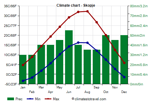
In Skopje, the capital, which is located in the north, at 250 meters (800 ft) above sea level, the average temperature ranges from 1 °C (34 °F) in January to 24 °C (75 °F) in July and August.
In winter, during cold spells, the temperature can drop to -20 °C (-4 °F) or even below. In January 1985 it dropped to -25.8 °C (-14.4 °F).
In summer, during heat waves, the temperature can reach or exceed 40 °C (104 °F).
In Skopje, precipitation does not reach 500 mm (20 in) per year.
Gevgelija
In the
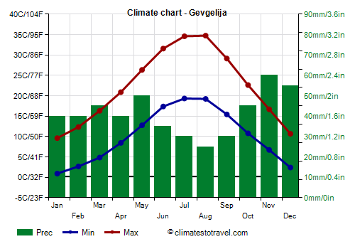
far south-east, we find an area located south of the mountain ranges that separate the country from the sea, where there are cities like Gevgelija and Valandovo, as well as Lake Dojran. Here, the climate is milder,
almost Mediterranean. A warm wind, called
Jug, can blow from the southeast, ie from Greece.
Gevgelija, on the Vardar river, is very hot in summer, and is one of the hottest cities in Europe: temperatures of 40 °C (104 °F) are not that rare. In July 2007, the temperature reached 45 °C (113 °F).
In winter, it is generally quite mild, but sometimes there can be cold periods, in which the temperature drops to -10 °C (14 °F).
Hills and mountains
In hilly areas, the temperature decreases as the altitude increases, especially in summer, while in winter it is not necessarily lower than in the valley floor, where cold air often stagnates.
Ohrid
In
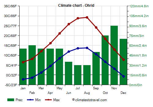
Ohrid, located in the southwest, on the shores of Lake Ohrid, at an altitude of 700 meters (2,300 feet), the average temperature in January, 2 °C (35.5 °F), is higher than that of Skopje, while in summer it is lower.
In Ohrid, the rains are a little more abundant than in Skopje, and amount to 660 mm (26 in) per year.
Lazaropole
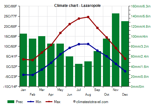
Going further up, above 1,000 metres (3,300 ft), the climate becomes colder and more rainy (and snowy in winter). In
Lazaropole, a village located in the west of the country, at an altitude of 1,300 meters (4,265 ft), near the Mavrovo National Park, the average temperature ranges from -0.5 °C (31 °F) in January to 18 °C (64.5 °F) in August.
In Lazaropole, 1,065 mm (42 in) of rain (or snow) fall per year. In winter, there are heavy snowfalls. In summer, thunderstorms can occur in the afternoon.
In the mountains, the sun shines less often than at low altitudes, especially in summer.
In
high mountain areas, the climate gets even colder, with heavy snowfalls in winter and afternoon thunderstorms in summer. In general, at a given altitude, the temperatures in winter are similar to those of the Alps.
The highest peak in North Macedonia is
Mount Korab, 2,764 meters (9,068 ft) high, located in the west, on the border with Albania.
Further north, in the
Šar Mountains (Shar Planina), there are some peaks exceeding 2,400 meters (7,875 ft), with the highest reaching 2,748 mt (9,016 ft).
In the southwest we find
Mount Baba, a massif whose highest peak, Pelister, is 2,601 meters (8,533 ft) high.
In the southeast, on the border with Greece, we find mountains that exceed 2,100 meters (6,890 ft).
When to go
The best time to visit North Macedonia is
from May to September.
In Skopje and the other cities located in the lowlands, the months of July and August (and sometimes the second half of June) can be really hot, so you may prefer
May, June and September. September is usually a pleasant month, sunny and with little rain.
What to pack
In
winter: bring warm clothes, such as a sweater or fleece, a down jacket, a hat, gloves and a scarf, and a raincoat or umbrella.
In
summer: bring light clothes, a T-shirt, but also long pants, a light jacket and a sweatshirt for the evening, and an umbrella.
Climate data - Macedonia
| Bitola (585 meters) |
|---|
|
| Jan | Feb | Mar | Apr | May | Jun | Jul | Aug | Sep | Oct | Nov | Dec |
|---|
| Min temp. | -4 | -1 | 2 | 6 | 10 | 13 | 15 | 15 | 11 | 7 | 3 | -1 |
|---|
| Max temp. | 4 | 8 | 13 | 17 | 22 | 28 | 30 | 31 | 25 | 20 | 13 | 6 |
|---|
| Precip. | 50 | 50 | 50 | 45 | 60 | 40 | 40 | 30 | 35 | 55 | 75 | 70 |
|---|
| Prec. days | 8 | 8 | 8 | 7 | 8 | 6 | 5 | 4 | 5 | 6 | 8 | 9 |
|---|
|
|
|
|
| Gevgelija |
|---|
|
| Jan | Feb | Mar | Apr | May | Jun | Jul | Aug | Sep | Oct | Nov | Dec |
|---|
| Min temp. | 1 | 3 | 5 | 8 | 13 | 17 | 19 | 19 | 15 | 11 | 7 | 2 |
|---|
| Max temp. | 10 | 12 | 16 | 21 | 26 | 32 | 35 | 35 | 29 | 23 | 17 | 11 |
|---|
| Precip. | 40 | 40 | 45 | 40 | 50 | 35 | 30 | 25 | 30 | 45 | 60 | 55 |
|---|
| Prec. days | 9 | 9 | 9 | 9 | 10 | 8 | 5 | 5 | 4 | 7 | 9 | 10 |
|---|
|
|
| Sun hours | 4 | 4 | 6 | 8 | 9 | 11 | 12 | 11 | 9 | 6 | 4 | 4 |
|---|
|
| Lazaropole (1,300 meters) |
|---|
|
| Jan | Feb | Mar | Apr | May | Jun | Jul | Aug | Sep | Oct | Nov | Dec |
|---|
| Min temp. | -4 | -4 | -2 | 2 | 6 | 9 | 11 | 11 | 8 | 5 | 1 | -2 |
|---|
| Max temp. | 4 | 3 | 7 | 11 | 17 | 21 | 24 | 25 | 19 | 14 | 9 | 4 |
|---|
| Precip. | 105 | 95 | 100 | 85 | 85 | 60 | 45 | 50 | 70 | 95 | 145 | 130 |
|---|
| Prec. days | 11 | 11 | 11 | 11 | 10 | 8 | 5 | 6 | 6 | 8 | 11 | 12 |
|---|
|
|
| Sun hours | 3 | 4 | 5 | 5 | 6 | 7 | 9 | 9 | 8 | 6 | 4 | 3 |
|---|
|
| Ohrid (700 meters) |
|---|
|
| Jan | Feb | Mar | Apr | May | Jun | Jul | Aug | Sep | Oct | Nov | Dec |
|---|
| Min temp. | -2 | -1 | 1 | 5 | 9 | 12 | 14 | 14 | 11 | 7 | 3 | -1 |
|---|
| Max temp. | 7 | 8 | 12 | 16 | 21 | 26 | 29 | 29 | 24 | 18 | 13 | 8 |
|---|
| Precip. | 55 | 60 | 55 | 55 | 55 | 35 | 30 | 30 | 50 | 75 | 90 | 70 |
|---|
| Prec. days | 11 | 12 | 11 | 13 | 12 | 8 | 6 | 6 | 7 | 10 | 12 | 13 |
|---|
|
|
|
|
| Skopje (250 meters) |
|---|
|
| Jan | Feb | Mar | Apr | May | Jun | Jul | Aug | Sep | Oct | Nov | Dec |
|---|
| Min temp. | -3 | -2 | 2 | 6 | 10 | 14 | 16 | 16 | 12 | 8 | 3 | -1 |
|---|
| Max temp. | 5 | 9 | 14 | 19 | 24 | 29 | 32 | 32 | 27 | 20 | 12 | 6 |
|---|
| Precip. | 30 | 30 | 40 | 40 | 45 | 55 | 40 | 35 | 35 | 50 | 45 | 50 |
|---|
| Prec. days | 10 | 9 | 10 | 10 | 11 | 10 | 7 | 6 | 6 | 7 | 9 | 11 |
|---|
|
|
| Sun hours | 3 | 4 | 5 | 7 | 8 | 9 | 10 | 10 | 8 | 6 | 4 | 3 |
|---|
|
| Stip (325 meters) |
|---|
|
| Jan | Feb | Mar | Apr | May | Jun | Jul | Aug | Sep | Oct | Nov | Dec |
|---|
| Min temp. | -2 | 0 | 3 | 7 | 12 | 16 | 17 | 17 | 13 | 9 | 4 | 0 |
|---|
| Max temp. | 6 | 9 | 14 | 19 | 24 | 29 | 32 | 32 | 27 | 20 | 13 | 7 |
|---|
| Precip. | 30 | 30 | 35 | 40 | 60 | 45 | 40 | 30 | 30 | 45 | 50 | 40 |
|---|
| Prec. days | 7 | 7 | 10 | 10 | 10 | 6 | 4 | 4 | 4 | 7 | 9 | 9 |
|---|
|
|
| Sun hours | 3 | 4 | 5 | 7 | 8 | 9 | 10 | 10 | 8 | 6 | 4 | 3 |
|---|
|
See also the
temperatures month by month