Select units of measurement for the temperature and rainfall tables (metric or imperial).
Average weather, temperature, rainfall, sunshine
Angola is a large African country, located in the southern hemisphere and overlooking the Atlantic Ocean, and its climate is tempered by a cool sea current along the coast and by the altitude in the plateau which is found in the interior. The result is a
sub-tropical climate almost everywhere.
From May to August, ie the austral winter, there is a
cool, dry season (called
Cacimbo), while in the austral summer, there is usually a
hot, rainy season. The latter runs from mid-September to April in the north-east, from mid-October to April in the center, from November to March in the south, while along the coast, it only goes from February to April in Luanda, and it's almost non-existent on the southern coast (which is therefore desert).
The cool sea current that flows along the coast, the
Benguela Current, makes the climate mild and dry, at least in the central and southern part; in the southernmost part of the coast, the climate is even desert.
In inland areas, the
rains are generally more abundant than on the coast, but here too, they are more abundant in the center and north because of the greater proximity to the Equator.
The climate in detail
The tropical zone
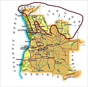
In the
northernmost area, where the plateau drops below 1,000 meters (3,300 feet), and in the northern part of the exclave of Cabinda (a small province detached from the main territory and overlooking the sea), the climate is
tropical, with a rainy season that runs from mid-October to mid-May in the western part (see M'banza-Kongo) and from mid-September to April in the eastern part (see Dundo). Rainfall exceeds 1,000 millimeters (40 inches) per annum everywhere.
M'banza-Kongo
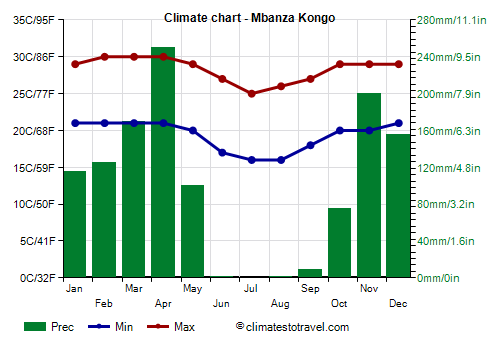
In M'banza-Kongo, located at 400 meters (1,300 feet) above sea level, rainfall amounts to 1,200 mm (47 in) per year.
The average temperature drops to around 21/22 °C (70/72 °F) in the austral winter, from June to August, while it remains around 25/26 °C (77/79 °F) for a long period (October to May). Very hot days are rare: usually, the temperature does not exceed 34/35 °C (93/95 °F), but during the rainy season, the air is moist, so the heat is unpleasant.
In the western part, there is not much sun, in fact, the sky is often cloudy even during the dry season.
In contrast, in the eastern part, the sun frequently shines, at least in the dry season.
The
best period to visit this area is from June to August, since it is the coolest, and within the dry season.
The coast
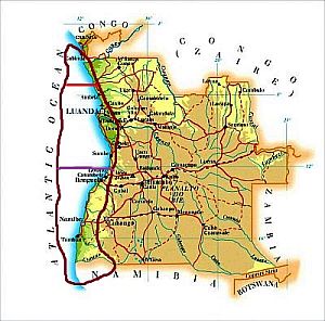
Along the
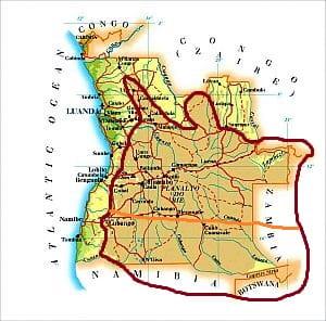
coast (which also includes the southern part of the Cabinda province), the climate is desert (but mild) in the southern part, semi-desert in the central part (between the two red lines, where the capital,
Luanda, is located), and semiarid in the northern part, where rainfall exceeds 500 mm (20 in) per year.
Although there's little rain,
fog, mists and low clouds are common, especially in winter, ie from June to October in the south (see Moçâmedes) and from July to October in Luanda.
In the north, in
Cabinda, there's not much sun, in fact, in winter, there are fogs and mists, while in the rainy season, which here begins to be substantial and runs from late October to early May, the sky is often cloudy.
The
average temperature is higher in the northern part of the coast, which is closer to the Equator: in Cabinda, it reaches a maximum of 26 °C (79 °F) from February to April and a minimum of 21 °C (70 °F) in July; in Luanda, it's around 26 °C (79 °F) from February to April and around 20 °C (68 °F) in July and August.
Anyway, the coastal area can experience
sudden increases in temperature when the wind blows from the interior, especially where the escarpment that separates the plain from the plateau is higher. In the central area, we find the highest peak of the country,
Morro de Moco, 2,620 meters (8,600 feet) high.
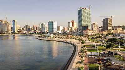
Luanda
In
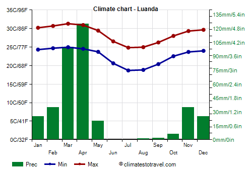
Luanda, the average temperature drops to around 22 °C (71.5 °F) in July and August, while it reaches 28 °C (82.5 °F) in March.
The only months with moderate rains are March and April.
In Luanda, the sun does not shine very often; however, the sunniest months are the dryest months of the first part of the year (January, February, and May), while the least sunny ones are those when the cool current prevails (from July to October), and fogs and low clouds are more easily formed.
The
sea temperature in Luanda is warm for many months of the year, while it becomes a little cool for swimming from July to September, when it drops to 21.5/22.5 °C (70.5/72.5 °F).
Moçâmedes

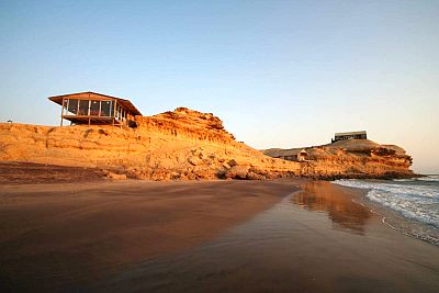
The southern part of the coast is cooler: in
Moçâmedes (formerly Namibe), the mean temperature reaches a maximum of 25 °C (77 °F) in March and a minimum of 17 °C (62.5 °F) in July.
Also, rainfall is very scarce, in fact, it is around 50 mm (2 in) per year.
In the southern part of the coast, the sun shines more often in March and April (since it almost never rains), while in winter, the sun becomes even rarer (since the cold current is felt more), especially from July to September.
In this area, the sea temperature is lower, and it becomes very cool in the winter months, around 18/19 °C (64/66 °F).
In the southern part of the coast, the
best period is summer, since it is not too hot and it is sunny, while winter is mild but damp and foggy.
The plateau
On the inland plateau, whose altitude generally ranges between 1,000 and 1,800 meters (3,300 and 6,000 feet), the climate is
sub-tropical, with a rainy season, which runs from October to April in the north, and from December to March in the south.
Generally, the
rainfall is between 1,200 and 1,600 mm (47 to 63 in) per annum in the center and north (above the orange line on the map), while it drops below 1,000 mm (40 in) in the south.
Between the tropics, the sun passes through the
zenith (that is, it shines directly overhead in the sky) at mid-day in two moments of the year, quite separated from each other (at the Equator, this event takes place at the equinoxes, that is, on March 21 and September 23), and this affects the rainfall pattern, producing two maxima within the rainy season, that is, in November-December and March-April in northern Angola. On the contrary, in the south, which is closer to the Tropic of Capricorn, the two solar peaks are very close to each other, so the wettest period is only one and goes from December to February, ie at the height of the summer.
Huambo
In
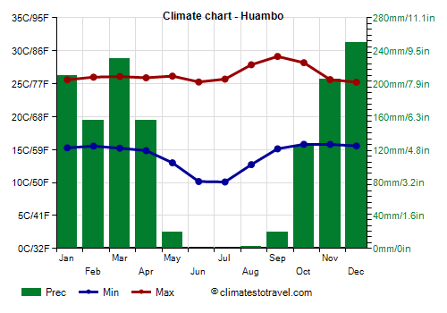
Huambo, located in the center of the plateau, at 1,700 meters (5,600 feet) above sea level, 1,365 mm (53.5 in) of rain fall per year.
On the plateau, during the coolest season, from May to August, the sun shines and it never rains, but there are wide variations in temperature between night and day, so nights are cold, sometimes close to freezing, while during the day, it can even get hot.
In Huambo, the sun often shines in the dry period, while it does not shine very often in the rainy season, from October to April.
Ondjiva

In the southernmost part of the plateau, near the border with Namibia, where the average altitude is around a thousand meters (3,300 feet), between September and November (that is, before the rainy season) it gets very hot. For example, in
Ondjiva, at 1,100 meters (3,600 feet) above sea level, in this period the maximum temperatures are around 33/35 °C (92/95 °F), but can sometimes reach 40 °C (104 °F).
As mentioned, in the southern part of the plateau, rainfall is scarcer than in the central and northern part, and the rainy season is also shorter.
In the southern part of the plateau, the sun shines even more often, especially in the summer, which here is less rainy.
On the plateau, the best time is from May to September.
When to go
The best time to visit Angola in its entirety runs from
mid-May to August, since it is the coolest and sunniest period, at least in inland areas, while fogs and low clouds are frequent along the coast, but at least it doesn't rain. On the plateau, winter nights are cold, and the temperature can even approach freezing, especially in the center and south. May and September can be acceptable months as well: they are a bit warmer, which means that the plateau is less cold at night, but during the day, it can get hot in the extreme south, while in the north-east, September is the month when the rains begin, and May when there are the last rains.
On the
coast, in Luanda, you can go for a beach holiday from December to June, since the sun often shines and it seldom rains, however, you can maybe avoid March and April, which are the only relatively rainy months; the best month is probably May. Further south, it rains still less, but the sea is cooler, so you can narrow the period to March and April. North of Luanda, sunshine is increasingly scarcer and rainfall more abundant, so this coastal area it's not the most recommended for beach tourism.
What to pack
In
winter (June to August): for the coast, bring spring/autumn clothes, a sweatshirt or sweater and a jacket, especially south of Luanda. For the northernmost area, light clothes for the day, a sweatshirt and a light jacket for the evening, and a sun hat. For the south-central plateau, light clothes for the day, but also a sweater, a jacket and a hat for the evening, and hiking shoes.
In
summer (December to February): along the coast, bring light clothing, a light sweatshirt for the evening, a light jacket for the southern part (see Namibe). For the northernmost area, light, loose-fitting clothes of natural fibers, a sun hat, a light sweatshirt for the evening, and a light raincoat or umbrella. For the south-central plateau, light clothes for the day, a sun hat, a sweatshirt and a spring jacket for the evening, a light raincoat or umbrella, and hiking shoes.
Climate data - Angola
| Huambo (1,700 meters) |
|---|
|
| Jan | Feb | Mar | Apr | May | Jun | Jul | Aug | Sep | Oct | Nov | Dec |
|---|
| Min temp. | 15 | 16 | 15 | 15 | 13 | 10 | 10 | 13 | 15 | 16 | 16 | 16 |
|---|
| Max temp. | 26 | 26 | 26 | 26 | 26 | 25 | 26 | 28 | 29 | 28 | 26 | 25 |
|---|
| Precip. | 210 | 155 | 230 | 155 | 20 | 0 | 0 | 0 | 20 | 125 | 205 | 250 |
|---|
| Prec. days | 16 | 14 | 17 | 10 | 2 | 0 | 0 | 0 | 3 | 13 | 18 | 17 |
|---|
|
|
| Sun hours | 5 | 5 | 5 | 6 | 8 | 9 | 9 | 8 | 7 | 5 | 4 | 4 |
|---|
|
| Luanda |
|---|
|
| Jan | Feb | Mar | Apr | May | Jun | Jul | Aug | Sep | Oct | Nov | Dec |
|---|
| Min temp. | 24 | 25 | 25 | 25 | 24 | 21 | 19 | 19 | 20 | 23 | 24 | 24 |
|---|
| Max temp. | 30 | 31 | 31 | 31 | 29 | 27 | 25 | 25 | 26 | 28 | 29 | 30 |
|---|
| Precip. | 25 | 35 | 100 | 125 | 20 | 0 | 0 | 0 | 0 | 5 | 35 | 25 |
|---|
| Prec. days | 2 | 3 | 7 | 9 | 2 | 0 | 0 | 0 | 0 | 2 | 3 | 3 |
|---|
| Humidity | 77% | 77% | 77% | 81% | 80% | 79% | 81% | 81% | 80% | 80% | 79% | 78% |
|---|
| Day length | 13 | 12 | 12 | 12 | 12 | 12 | 12 | 12 | 12 | 12 | 12 | 13 |
|---|
| Sun hours | 7 | 7 | 7 | 6 | 7 | 7 | 5 | 5 | 5 | 5 | 6 | 6 |
|---|
| Sea temp | 27 | 28 | 29 | 28 | 27 | 24 | 22 | 22 | 23 | 25 | 26 | 27 |
|---|
| Luena (1,355 meters) |
|---|
|
| Jan | Feb | Mar | Apr | May | Jun | Jul | Aug | Sep | Oct | Nov | Dec |
|---|
| Min temp. | 18 | 18 | 18 | 18 | 17 | 14 | 14 | 16 | 19 | 19 | 19 | 19 |
|---|
| Max temp. | 27 | 27 | 28 | 27 | 28 | 26 | 27 | 29 | 31 | 30 | 28 | 27 |
|---|
| Precip. | 225 | 190 | 200 | 100 | 5 | 0 | 0 | 0 | 20 | 90 | 170 | 215 |
|---|
| Prec. days | 22 | 20 | 23 | 12 | 2 | 0 | 0 | 0 | 3 | 13 | 20 | 23 |
|---|
|
|
| Sun hours | 4 | 5 | 5 | 6 | 8 | 9 | 9 | 9 | 7 | 6 | 4 | 4 |
|---|
|
| Mbanza Kongo (400 meters) |
|---|
|
| Jan | Feb | Mar | Apr | May | Jun | Jul | Aug | Sep | Oct | Nov | Dec |
|---|
| Min temp. | 21 | 21 | 21 | 21 | 20 | 17 | 16 | 16 | 18 | 20 | 20 | 21 |
|---|
| Max temp. | 29 | 30 | 30 | 30 | 29 | 27 | 25 | 26 | 27 | 29 | 29 | 29 |
|---|
| Precip. | 115 | 125 | 170 | 250 | 100 | 0 | 0 | 0 | 10 | 75 | 200 | 155 |
|---|
| Prec. days | 7 | 7 | 10 | 12 | 6 | 0 | 0 | 2 | 2 | 7 | 11 | 10 |
|---|
|
|
| Sun hours | 5 | 6 | 6 | 6 | 6 | 6 | 5 | 4 | 4 | 4 | 5 | 4 |
|---|
|
| Moçâmedes |
|---|
|
| Jan | Feb | Mar | Apr | May | Jun | Jul | Aug | Sep | Oct | Nov | Dec |
|---|
| Min temp. | 19 | 20 | 21 | 19 | 15 | 13 | 13 | 14 | 15 | 16 | 17 | 18 |
|---|
| Max temp. | 27 | 28 | 29 | 28 | 26 | 22 | 21 | 21 | 22 | 24 | 25 | 26 |
|---|
| Precip. | 5 | 10 | 15 | 10 | 0 | 0 | 0 | 0 | 0 | 0 | 0 | 5 |
|---|
| Prec. days | 2 | 2 | 3 | 2 | 0 | 0 | 0 | 1 | 0 | 1 | 1 | 1 |
|---|
|
|
| Sun hours | 7 | 7 | 8 | 8 | 7 | 5 | 3 | 4 | 4 | 5 | 7 | 7 |
|---|
| Sea temp | 24 | 25 | 26 | 25 | 23 | 21 | 19 | 19 | 19 | 21 | 22 | 23 |
|---|
| Ondjiva (1,100 meters) |
|---|
|
| Jan | Feb | Mar | Apr | May | Jun | Jul | Aug | Sep | Oct | Nov | Dec |
|---|
| Min temp. | 18 | 18 | 17 | 16 | 11 | 7 | 6 | 8 | 13 | 17 | 18 | 18 |
|---|
| Max temp. | 32 | 31 | 30 | 30 | 29 | 27 | 27 | 30 | 33 | 35 | 34 | 32 |
|---|
| Precip. | 105 | 145 | 120 | 55 | 5 | 0 | 0 | 0 | 0 | 15 | 50 | 125 |
|---|
| Prec. days | 10 | 12 | 9 | 4 | 1 | 1 | 0 | 0 | 0 | 2 | 6 | 8 |
|---|
|
|
| Sun hours | 7 | 8 | 8 | 9 | 10 | 11 | 10 | 10 | 11 | 8 | 9 | 8 |
|---|
|
See also the
temperatures month by month