Select units of measurement for the temperature and rainfall tables (metric or imperial).
Average weather, temperature, rainfall, sunshine
In Zimbabwe, the climate is generally
sub-tropical, with a hot, humid and rainy season from mid-November to March, and a dry season from April to mid-November.
Within the dry season, there is a
cool period from mid-May to mid-August, and a progressively
hotter period from September to mid-November, before the rains, which is the hottest of the year, even though the air is still dry.
Zimbabwe, formerly Rhodesia, is a country located in southern Africa, just north of the Tropic of Capricorn, and almost entirely occupied by a
plateau, at an altitude between 1,000 and 1,500 meters (3,300 and 4,900 feet), which tempers the climate.
The
temperature in Zambia varies according to altitude and latitude.
In much of the country,
rainfall is from relatively low to moderate, in fact it ranges from 550 to 900 millimeters (21.5 to 35.5 inches). The rains occur primarily in the form of showers and thunderstorms in the afternoon. The wettest regions are the north and the east.
This kind of climate, with a long dry season, produces almost everywhere a
savannah landscape.
However, in the
highest mountains, forests are found. The highest peak is Mount Nyangani, 2,592 meters (8,504 feet) high, located in the east, in the Nyanga National Park.
The climate in detail
The lowlands
The driest region is the south, in the
Limpopo Valley, on the border with South Africa, where rainfall drops below 400 mm (16 in) per year (see
Beitbridge).
In the latter region, the
altitude drops to around 500/600 meters (1,600/2,000 feet), while in the south-eastern strip, at the border with Mozambique, where the
Gonarezhou National Park is found, it goes down to around 200/300 meters (650/1,000 feet).
Kariba

Another area where the altitude drops to around 500 meters (1,600 feet) is found in the north and is that of
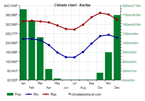
Lake Kariba. It goes without saying that the areas where the altitude is lower are also the hottest, in fact, in October and November, highs can reach 40 °C (104 °F).
In
Kariba, located near the lake of the same name, and at 500 meters (1,600 feet) above sea level, the maximum temperatures in October and November are of 35/36 °C (95/97 °F).
The plateau
On the plateau, the night temperature from May to August drops a lot, becoming very cool, and sometimes even cold.
Victoria Falls

The famous
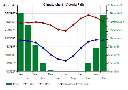
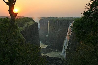
Victoria Falls are located in the north-west, in the Zambezi River, about 1,000 meters (3,300 feet) above sea level. Here, the minimum temperatures drop below 10 °C (50 °F) from June to August.

The
Hwange National Park is located in the south-west, it covers nearly 15,000 square kilometers (6,000 sq mi), and it's home to a large number of animals of the savannah such as lions, elephants and cheetahs.
Harare

The capital,
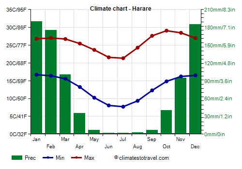
Harare, is located in the northeast of the country, at 1,500 meters (5,000 feet) above sea level, and has a temperate climate. It is warm from September to March, with highs around 27/29 °C (80/84 °F), even though there's a bit of sticky heat at the height of the rainy season, ie from December to March.
The dry season, from May to August, is cooler, with highs around 21/24 °C (70/75 °F) and lows around 8/10 °C (46/50 °F). In the coldest nights, the temperature can approach freezing (0 °C or 32 °F). The coolest period, however, is also the sunniest.
In October and November, it can be hot during the day, but not as much as in the lowlands, below 1,000 meters (3,300 feet).
In Harare, 840 mm (33 in) of rain fall in an average year, of which more than 150 mm (6 in) fall from December to February, while it almost never rains from May to September.
In Harare, and in general in Zimbabwe, the sun regularly shines in the dry period, while in the rainy season, the sun alternates with the clouds.
Tropical cyclones
Sometimes, Zimbabwe can be affected by
tropical cyclones, which originate in the Indian Ocean, and after passing over Mozambique, they can reach the eastern regions of the country. Typically, they
lose strength when penetrating the mainland, but they are still able to bring a good amount of wind and rain.
Some cyclones that hit the country in the past were: Leon-Eline in late February 2000, Japhet in early March 2003, Dineo in mid-February 2017, and Idai in march 2019.
The cyclone season runs from mid-November to May, but they are most likely from late December to mid-April. This is one more reason to avoid the rainy and sultry season.
When to go
The best time to visit Zimbabwe runs from
mid-May to August, in fact, it is the coolest and sunniest, and with almost no rain, even though it can get cold at night, especially above 1,500 meters (5,000 feet).
Usually, by mid-August, the temperature begins to rise, and cold nights become less likely.
In September and October, the heat can be intense during the day, although nights remain cool at high altitude.
The rainiest and muggiest period, and therefore the least advisable, runs from December to February.
What to pack
In
winter (June to August): pack light clothes for the day, but also a sweater, a jacket, and a hat for the evening.
In
summer (December to February): pack light clothes for the day, and a sun hat; a sweatshirt and a spring jacket for the evening, especially above 1,000 meters (3,300 feet); a light raincoat or an umbrella.
Climate data - Zimbabwe
| Beitbridge (470 meters) |
|---|
|
| Jan | Feb | Mar | Apr | May | Jun | Jul | Aug | Sep | Oct | Nov | Dec |
|---|
| Min temp. | 22 | 22 | 21 | 17 | 13 | 10 | 10 | 12 | 16 | 19 | 21 | 22 |
|---|
| Max temp. | 34 | 34 | 33 | 31 | 29 | 27 | 26 | 28 | 31 | 33 | 33 | 34 |
|---|
| Precip. | 55 | 55 | 35 | 25 | 10 | 5 | 0 | 0 | 15 | 30 | 50 | 55 |
|---|
| Prec. days | 5 | 4 | 3 | 2 | 1 | 1 | 0 | 0 | 1 | 2 | 5 | 5 |
|---|
| Humidity | 59% | 58% | 58% | 57% | 53% | 54% | 53% | 47% | 46% | 49% | 53% | 56% |
|---|
| Day length | 13 | 13 | 12 | 12 | 11 | 11 | 11 | 11 | 12 | 13 | 13 | 14 |
|---|
| Sun hours | 8 | 8 | 8 | 8 | 9 | 8 | 8 | 9 | 8 | 8 | 8 | 7 |
|---|
|
| Bulawayo (1,350 meters) |
|---|
|
| Jan | Feb | Mar | Apr | May | Jun | Jul | Aug | Sep | Oct | Nov | Dec |
|---|
| Min temp. | 17 | 17 | 16 | 14 | 11 | 9 | 8 | 10 | 14 | 16 | 17 | 17 |
|---|
| Max temp. | 29 | 29 | 28 | 27 | 26 | 23 | 23 | 26 | 30 | 31 | 30 | 29 |
|---|
| Precip. | 120 | 105 | 70 | 35 | 5 | 0 | 0 | 0 | 5 | 40 | 90 | 120 |
|---|
| Prec. days | 10 | 8 | 6 | 3 | 1 | 1 | 0 | 0 | 1 | 4 | 8 | 10 |
|---|
| Humidity | 63% | 63% | 63% | 56% | 47% | 47% | 46% | 37% | 34% | 39% | 49% | 62% |
|---|
| Day length | 13 | 13 | 12 | 12 | 11 | 11 | 11 | 12 | 12 | 13 | 13 | 13 |
|---|
| Sun hours | 8 | 8 | 8 | 8 | 9 | 9 | 9 | 10 | 10 | 9 | 8 | 7 |
|---|
|
| Chipinge (1,100 meters) |
|---|
|
| Jan | Feb | Mar | Apr | May | Jun | Jul | Aug | Sep | Oct | Nov | Dec |
|---|
| Min temp. | 17 | 17 | 16 | 14 | 12 | 10 | 10 | 11 | 13 | 14 | 16 | 16 |
|---|
| Max temp. | 27 | 26 | 26 | 24 | 23 | 22 | 20 | 23 | 26 | 27 | 27 | 26 |
|---|
| Precip. | 210 | 205 | 145 | 60 | 30 | 15 | 20 | 20 | 25 | 55 | 105 | 210 |
|---|
| Prec. days | 12 | 12 | 10 | 5 | 4 | 4 | 3 | 4 | 4 | 6 | 9 | 11 |
|---|
| Humidity | 78% | 78% | 78% | 73% | 66% | 64% | 65% | 59% | 57% | 63% | 68% | 74% |
|---|
| Day length | 13 | 13 | 12 | 12 | 11 | 11 | 11 | 12 | 12 | 13 | 13 | 13 |
|---|
| Sun hours | 8 | 7 | 7 | 8 | 8 | 8 | 8 | 9 | 9 | 8 | 8 | 7 |
|---|
|
| Chiredzi (430 meters) |
|---|
|
| Jan | Feb | Mar | Apr | May | Jun | Jul | Aug | Sep | Oct | Nov | Dec |
|---|
| Min temp. | 21 | 20 | 19 | 16 | 12 | 10 | 10 | 11 | 15 | 18 | 20 | 20 |
|---|
| Max temp. | 32 | 32 | 31 | 30 | 28 | 26 | 26 | 28 | 31 | 33 | 33 | 33 |
|---|
| Precip. | 125 | 115 | 60 | 25 | 15 | 10 | 5 | 5 | 15 | 25 | 75 | 115 |
|---|
| Prec. days | 10 | 10 | 8 | 4 | 3 | 3 | 2 | 2 | 3 | 5 | 8 | 10 |
|---|
| Humidity | 67% | 69% | 69% | 65% | 60% | 61% | 58% | 52% | 50% | 52% | 55% | 60% |
|---|
| Day length | 13 | 13 | 12 | 12 | 11 | 11 | 11 | 11 | 12 | 13 | 13 | 13 |
|---|
|
|
| Gweru (1,450 meters) |
|---|
|
| Jan | Feb | Mar | Apr | May | Jun | Jul | Aug | Sep | Oct | Nov | Dec |
|---|
| Min temp. | 16 | 15 | 14 | 11 | 8 | 5 | 5 | 7 | 10 | 13 | 15 | 15 |
|---|
| Max temp. | 27 | 27 | 26 | 25 | 24 | 22 | 21 | 24 | 28 | 29 | 28 | 27 |
|---|
| Precip. | 140 | 125 | 55 | 30 | 10 | 0 | 0 | 0 | 10 | 35 | 95 | 160 |
|---|
| Prec. days | 12 | 10 | 7 | 3 | 1 | 1 | 0 | 0 | 1 | 4 | 9 | 12 |
|---|
| Humidity | 71% | 71% | 69% | 65% | 55% | 55% | 53% | 45% | 40% | 45% | 56% | 69% |
|---|
| Day length | 13 | 13 | 12 | 12 | 11 | 11 | 11 | 12 | 12 | 13 | 13 | 13 |
|---|
|
|
| Harare (1,500 meters) |
|---|
|
| Jan | Feb | Mar | Apr | May | Jun | Jul | Aug | Sep | Oct | Nov | Dec |
|---|
| Min temp. | 17 | 16 | 16 | 13 | 10 | 8 | 8 | 9 | 12 | 15 | 16 | 17 |
|---|
| Max temp. | 27 | 27 | 27 | 25 | 24 | 22 | 21 | 24 | 28 | 29 | 28 | 27 |
|---|
| Precip. | 190 | 175 | 100 | 35 | 5 | 0 | 0 | 5 | 5 | 40 | 95 | 185 |
|---|
| Prec. days | 17 | 14 | 10 | 5 | 2 | 1 | 0 | 1 | 1 | 5 | 10 | 16 |
|---|
| Humidity | 73% | 72% | 71% | 65% | 58% | 56% | 53% | 46% | 41% | 46% | 57% | 70% |
|---|
| Day length | 13 | 13 | 12 | 12 | 11 | 11 | 11 | 12 | 12 | 12 | 13 | 13 |
|---|
| Sun hours | 7 | 7 | 8 | 8 | 9 | 9 | 9 | 10 | 10 | 9 | 8 | 6 |
|---|
|
| Hwange National Park (1,000 meters) |
|---|
|
| Jan | Feb | Mar | Apr | May | Jun | Jul | Aug | Sep | Oct | Nov | Dec |
|---|
| Min temp. | 19 | 18 | 17 | 13 | 9 | 6 | 6 | 8 | 13 | 17 | 18 | 18 |
|---|
| Max temp. | 29 | 30 | 30 | 29 | 27 | 25 | 24 | 28 | 32 | 33 | 32 | 30 |
|---|
| Precip. | 150 | 135 | 70 | 30 | 5 | 0 | 0 | 0 | 5 | 25 | 60 | 145 |
|---|
| Prec. days | 16 | 14 | 9 | 4 | 1 | 0 | 0 | 0 | 1 | 4 | 10 | 15 |
|---|
| Humidity | 72% | 67% | 66% | 57% | 50% | 50% | 47% | 40% | 33% | 37% | 50% | 64% |
|---|
| Day length | 13 | 13 | 12 | 12 | 11 | 11 | 11 | 12 | 12 | 13 | 13 | 13 |
|---|
|
|
| Kariba (500 meters) |
|---|
|
| Jan | Feb | Mar | Apr | May | Jun | Jul | Aug | Sep | Oct | Nov | Dec |
|---|
| Min temp. | 22 | 22 | 22 | 19 | 15 | 12 | 12 | 15 | 20 | 24 | 24 | 23 |
|---|
| Max temp. | 32 | 32 | 32 | 31 | 29 | 28 | 27 | 30 | 34 | 36 | 35 | 33 |
|---|
| Precip. | 190 | 160 | 115 | 30 | 5 | 0 | 0 | 0 | 0 | 20 | 75 | 175 |
|---|
| Prec. days | 16 | 13 | 10 | 3 | 1 | 0 | 0 | 0 | 0 | 2 | 7 | 14 |
|---|
| Humidity | 73% | 72% | 71% | 64% | 59% | 60% | 53% | 46% | 37% | 36% | 47% | 64% |
|---|
| Day length | 13 | 13 | 12 | 12 | 11 | 11 | 11 | 12 | 12 | 12 | 13 | 13 |
|---|
|
|
| Karoi (1,250 meters) |
|---|
|
| Jan | Feb | Mar | Apr | May | Jun | Jul | Aug | Sep | Oct | Nov | Dec |
|---|
| Min temp. | 17 | 17 | 16 | 14 | 11 | 9 | 8 | 10 | 13 | 16 | 17 | 17 |
|---|
| Max temp. | 27 | 26 | 27 | 26 | 25 | 23 | 22 | 25 | 28 | 30 | 29 | 27 |
|---|
| Precip. | 180 | 190 | 110 | 40 | 5 | 0 | 0 | 0 | 5 | 20 | 75 | 175 |
|---|
| Prec. days | 17 | 16 | 11 | 4 | 2 | 1 | 0 | 0 | 1 | 3 | 9 | 15 |
|---|
| Humidity | 78% | 80% | 77% | 69% | 63% | 60% | 55% | 49% | 42% | 46% | 57% | 71% |
|---|
| Day length | 13 | 13 | 12 | 12 | 11 | 11 | 11 | 12 | 12 | 12 | 13 | 13 |
|---|
| Sun hours | 6 | 6 | 7 | 8 | 9 | 9 | 9 | 10 | 10 | 9 | 7 | 6 |
|---|
|
| Masvingo (1,090 meters) |
|---|
|
| Jan | Feb | Mar | Apr | May | Jun | Jul | Aug | Sep | Oct | Nov | Dec |
|---|
| Min temp. | 18 | 17 | 16 | 13 | 8 | 6 | 6 | 8 | 12 | 15 | 17 | 17 |
|---|
| Max temp. | 28 | 29 | 28 | 26 | 25 | 23 | 22 | 25 | 28 | 30 | 30 | 29 |
|---|
| Precip. | 130 | 105 | 65 | 30 | 15 | 5 | 5 | 5 | 10 | 30 | 75 | 140 |
|---|
| Prec. days | 10 | 8 | 6 | 3 | 2 | 2 | 1 | 1 | 1 | 3 | 7 | 10 |
|---|
| Humidity | 70% | 69% | 71% | 67% | 59% | 60% | 57% | 49% | 45% | 49% | 58% | 67% |
|---|
| Day length | 13 | 13 | 12 | 12 | 11 | 11 | 11 | 12 | 12 | 13 | 13 | 13 |
|---|
| Sun hours | 8 | 7 | 8 | 8 | 9 | 8 | 8 | 9 | 9 | 8 | 8 | 7 |
|---|
|
| Mutoko (1,265 meters) |
|---|
|
| Jan | Feb | Mar | Apr | May | Jun | Jul | Aug | Sep | Oct | Nov | Dec |
|---|
| Min temp. | 18 | 17 | 17 | 14 | 11 | 9 | 9 | 11 | 13 | 16 | 17 | 17 |
|---|
| Max temp. | 27 | 27 | 27 | 27 | 25 | 23 | 22 | 24 | 27 | 29 | 29 | 28 |
|---|
| Precip. | 190 | 165 | 85 | 35 | 10 | 5 | 5 | 0 | 5 | 25 | 75 | 175 |
|---|
| Prec. days | 15 | 14 | 8 | 4 | 2 | 1 | 1 | 0 | 1 | 2 | 8 | 14 |
|---|
| Humidity | 74% | 73% | 72% | 64% | 59% | 59% | 54% | 49% | 43% | 46% | 54% | 68% |
|---|
| Day length | 13 | 13 | 12 | 12 | 11 | 11 | 11 | 12 | 12 | 12 | 13 | 13 |
|---|
|
|
| Rusape (1,430 meters) |
|---|
|
| Jan | Feb | Mar | Apr | May | Jun | Jul | Aug | Sep | Oct | Nov | Dec |
|---|
| Min temp. | 16 | 16 | 15 | 12 | 8 | 6 | 6 | 7 | 10 | 13 | 15 | 16 |
|---|
| Max temp. | 26 | 26 | 26 | 24 | 23 | 21 | 20 | 23 | 27 | 28 | 28 | 26 |
|---|
| Precip. | 165 | 150 | 80 | 35 | 10 | 5 | 5 | 5 | 10 | 40 | 105 | 170 |
|---|
| Prec. days | 13 | 10 | 8 | 4 | 2 | 2 | 1 | 1 | 1 | 4 | 9 | 12 |
|---|
| Humidity | 72% | 72% | 72% | 67% | 61% | 61% | 58% | 49% | 45% | 48% | 58% | 70% |
|---|
| Day length | 13 | 13 | 12 | 12 | 11 | 11 | 11 | 12 | 12 | 12 | 13 | 13 |
|---|
|
|
| Victoria Falls (900 meters) |
|---|
|
| Jan | Feb | Mar | Apr | May | Jun | Jul | Aug | Sep | Oct | Nov | Dec |
|---|
| Min temp. | 19 | 18 | 17 | 14 | 10 | 7 | 6 | 9 | 14 | 18 | 19 | 19 |
|---|
| Max temp. | 29 | 29 | 30 | 29 | 28 | 25 | 25 | 28 | 32 | 34 | 33 | 30 |
|---|
| Precip. | 175 | 140 | 80 | 25 | 5 | 0 | 0 | 0 | 0 | 25 | 70 | 170 |
|---|
| Prec. days | 16 | 14 | 9 | 3 | 0 | 0 | 0 | 0 | 0 | 4 | 11 | 16 |
|---|
| Humidity | 73% | 72% | 66% | 56% | 47% | 46% | 45% | 37% | 30% | 33% | 47% | 65% |
|---|
| Day length | 13 | 13 | 12 | 12 | 11 | 11 | 11 | 12 | 12 | 12 | 13 | 13 |
|---|
| Sun hours | 7 | 7 | 8 | 9 | 10 | 10 | 10 | 10 | 10 | 9 | 8 | 7 |
|---|
|
See also the
temperatures month by month