Select units of measurement for the temperature and rainfall tables (metric or imperial).
Average weather, temperature, rainfall, sunshine
Namibia, formerly South-West Africa, has a
sub-tropical climate, desert along the coast and in the south, and arid, but with a rainy season from November to March, in inland north-central areas and in the north-east.
Being in the Southern Hemisphere, its seasons are reversed in comparison with Europe or North America, and the coolest period is from May to August.
The country is crossed by the Tropic of Capricorn, but a
cold current, called Benguela Current, flows along the coast, while the interior is occupied by a
plateau.
As a result, the climate is cooler and drier than you might think.
Nevertheless, it can get
hot in summer, especially at some distance from the sea and in areas located at not too high altitudes. There may be blistering days from September to March in the north, from November to January in Windhoek, which is located in the center and at a pretty high altitude, and from September to Avril or early May in the center-south.
On the contrary, during winter, the plateau can get
cold at night, with possible light frosts everywhere.
The country is home to nature reserves and parks of great beauty, like the Etosha National Park.
The driest region is the coastal area, where the
Namib Desert is located, as well as the south, where the
Kalahari Desert is found. The latter is slightly rainier, and it's home to xerophyte plants such as cacti and other succulent species.
The rainiest area of Namibia is the north-east, where rainfall ranges from 500 to 600 millimeters (20 to 23.5 inches) per year.
Winter is dry everywhere, while in non-desert regions (north and east) it rains in summer, from November to March, usually in the form of showers or thunderstorms in the afternoon. The peak of the rainy season is from January to March.
The climate in detail
The coast
Along the coast, the climate is
desert but mild. It almost never rains, but the air is humid and there are often
fogs, mists and low clouds, especially in the early hours of the day. Temperatures are mild all year round, but with fog, humidity and wind, you can feel cold, especially in winter.
Swakopmund
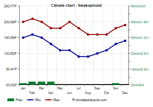
In
Swakopmund, in the central part of the coast, temperatures are milder from January to March, and cooler from July to October. Rain is practically absent.
Owing to the already mentioned mists and low clouds, which are more frequent at night and in the morning, the amount of sunshine in Swakopmund is decent, but not great, all year round.
The
sea in Swakopmund is very cool, if not cold, all year round, however, it reaches 17 °C (63 °F) from January to March. Only in the northernmost part of the Skeleton Coast, the sea is a bit warmer, and it reaches 22/23 °C (72/73 °F) in March.
Along the coast, the temperature can soar when the
warm wind called
Oosweer blows from inland, which can also cause sandstorms.
In addition, it's sufficient to move inland for not too many kilometers, to notice the tempering effect of the sea. In fact, as you move away from the coast, the air temperature increases rapidly, at least during the day and in summer. To understand how strong is the cooling influence of the sea, it's enough to say that in summer, the temperatures in inland areas are higher than on the coast even above 1,500 meters (5,000 feet) of altitude.
The coast is not advisable for beach tourism, but rather for watching birds, or animals such as sea lions at Cape Cross, as well as the remains of shipwrecks of the past centuries on the Skeleton Coast to the north.
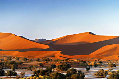
In the west, about 600 meters (2,000 feet) above sea level, in the area of the ancient Tsauchab river, today almost always dry, there are salt and clay pans (called
Sossusvlei), which are almost always dry as well, and are surrounded by huge orange
sand dunes, probably the highest sand dunes in the world. In particular, the "Big Daddy" dune is about 390 meters (1,280 feet) high. Another very high dune, the so-called "Dune 7", is located near the coast, near Walvis Bay, and is about 385 meters (1,263 feet) high. In the Sandwich Bay area, there are very high sand dunes right near the sea.
The plateau
The interior of the country, already a short distance from the sea, is occupied by a
plateau, whose altitude ranges from 1,200 to 1,700 meters (3,900 to 5,600 ft).
Occasionally, there are higher zones, and mountain peaks exceeding 2,000 meters (6,500 feet), for instance the Brandberg Massif.
In the southern regions (Hardap and Karas), in the hottest months (December and January), the maximum temperatures are around 35 °C at 1,000 meters (95 °F at 3,300 feet) of altitude. In the north, where the rainy season is more pronounced, the temperatures in the warmest months are a bit lower, and highs are around 30 °C (86 °F). North of the Tropic, the warmest period is from September to November, before the rainy season.
Tsumeb
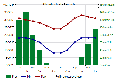
For example, in
Tsumeb, located in the north at 1,300 meters (4,250 feet) of altitude, the hottest month is October, when daytime temperatures are slightly higher than in January, that is, 33 °C (91 °F) instead of 31 °C (88 °F), while in the Zambezi Region, in the far north-east, average highs in October are around 35 °C (95 °F).
In Tsumeb, 555 mm or rain fall per year.
The sun in Tsumeb shines all year round, but especially in the dry season, from May to September, when the sky is almost always serene.
As mentioned, the north, where Tsumeb is located, is the wettest area of the country. In the vast
Etosha National Park, where there are protected species such as the black rhino, we find the Etosha Pan, a salt lake located not far from Tsumeb and 1,100 meters (3,600 feet) above sea level, which is dry most of the year, but becomes a shallow lake during the rainy season. In the wettest years, there may be flooding in the Etosha region and in the Cuvelai Basin.
The
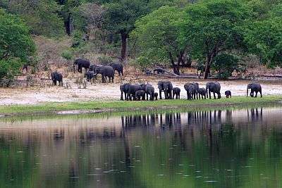
northeast is the rainiest area: the Kavango Region and the Caprivi Strip are covered by the savannah biome, also, there are major rivers such as Okavango and Zambezi, along whose banks the forest flourishes.
Windhoek
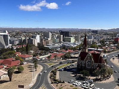
In the capital,
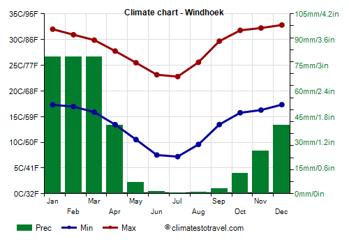
Windhoek, located in the center of the country and 1,700 meters (5,600 ft) above sea level, the average temperature ranges from 15 °C (59 °F) in July to 25 °C (77 °F) in December. So, the summer is hot despite the altitude, and it's much warmer than along the coast. In winter, the days are very mild, actually, they are even slightly warm, but it can get cold at night.
Winter is a very sunny season, during which it almost never rains. On the other hand, from November to April, some rain falls, but the rainfall reaches on average 70/80 mm (2.8/3.1 in) per month only from January to March. Total annual rainfall is 370 mm (14.5 in), so the climate is arid, but during some years, when tropical air masses from Angola arrive up here, in the rainy season, it can rain a lot.
In Windhoek too, as generally in the plateau, the sun shines all year round, with a maximum in the dry season.
In the southern part of the plateau, the climate is more arid; in fact, as mentioned, we are in the
Kalahari desert. Here, the summer rains are too poor to lower the temperature, so the hottest season is the precisely the summer, with highs of 36/37 °C (97/99 °F) from December to February, and peaks around 40 °C (104 °F) and above. On the other hand, at a given altitude, the southern position makes the winter colder than in the center and north.
Keetmanshoop
For example, in
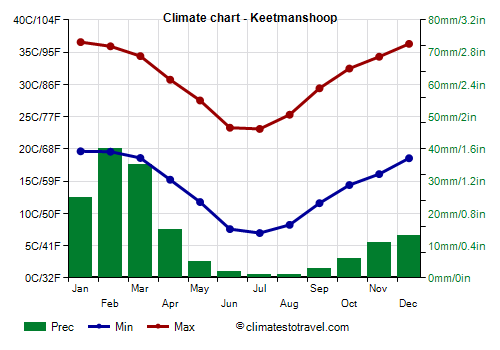
Keetmanshoop, located in the south, at 1,000 meters (3,300 feet) of altitude, temperatures in winter are similar to those of Windhoek, while is summer they are higher.
Keetmanshoop receives a desert-like amount of rainfall, 145 mm (5.7 in) per year, with a maximum of 40 mm (1.6 in) in February.
Southwest of Keetmanshoop, shared by Namibia and South Africa, is the
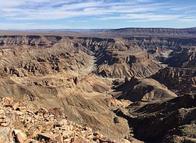
Ai-|Ais/Richtersveld Transfrontier Park. In areas located at low altitudes (see the Fish River Canyon, and also the Orange River, which marks the border with South Africa, where the altitude drops to sea level in villages like Aussenkehr and Noordoewer), in the hot period, the temperature can reach 45 °C (113 °F).
When to go
The best time to visit Namibia as a whole is the austral winter, from
May to August: it's a dry and sunny period, and it's the only one that allows to avoid the intense heat; on the plateau, however, nights are cold.
It is true that it is cool along the
coast, and there are fogs in the morning (on the coast, the best time would be
from November to February).
What to pack
In
winter (June to August): on the coast, bring spring/autumn clothes, and a sweatshirt or sweater and a jacket. In Windhoek and the plateau, bring spring/autumn clothes, being ready to add or remove the outer layer; a sweater, a hat and a warm jacket for the evening.
In
summer (December to February): along the coast, bring spring/autumn clothes, a T-shirt, a shirt, a sweatshirt, and a light jacket. In Windhoek and the plateau, light clothes for the day, a sun hat, a sweatshirt for the evening, and a light raincoat or umbrella.
Climate data - Namibia
| Gobabis (1,450 meters) |
|---|
|
| Jan | Feb | Mar | Apr | May | Jun | Jul | Aug | Sep | Oct | Nov | Dec |
|---|
| Min temp. | 18 | 18 | 16 | 13 | 8 | 4 | 4 | 6 | 10 | 14 | 16 | 18 |
|---|
| Max temp. | 34 | 33 | 32 | 30 | 28 | 25 | 25 | 28 | 31 | 34 | 35 | 34 |
|---|
| Precip. | 75 | 90 | 60 | 40 | 5 | 5 | 0 | 0 | 5 | 15 | 40 | 40 |
|---|
| Prec. days | 3 | 3 | 2 | 1 | 0 | 0 | 0 | 0 | 0 | 1 | 1 | 2 |
|---|
| Humidity | 51% | 54% | 57% | 53% | 39% | 33% | 35% | 26% | 25% | 29% | 37% | 44% |
|---|
| Day length | 13 | 13 | 12 | 12 | 11 | 11 | 11 | 11 | 12 | 13 | 13 | 14 |
|---|
|
|
| Grootfontein (1,400 meters) |
|---|
|
| Jan | Feb | Mar | Apr | May | Jun | Jul | Aug | Sep | Oct | Nov | Dec |
|---|
| Min temp. | 18 | 18 | 17 | 14 | 10 | 7 | 6 | 9 | 14 | 17 | 18 | 18 |
|---|
| Max temp. | 31 | 31 | 30 | 29 | 27 | 25 | 24 | 28 | 32 | 34 | 33 | 32 |
|---|
| Precip. | 120 | 95 | 70 | 30 | 0 | 15 | 0 | 5 | 25 | 25 | 60 | 80 |
|---|
| Prec. days | 7 | 7 | 5 | 2 | 0 | 0 | 0 | 0 | 1 | 3 | 5 | 7 |
|---|
| Humidity | 57% | 58% | 59% | 47% | 40% | 37% | 36% | 27% | 24% | 28% | 39% | 49% |
|---|
| Day length | 13 | 13 | 12 | 12 | 11 | 11 | 11 | 12 | 12 | 13 | 13 | 13 |
|---|
|
|
| Keetmanshoop (1,000 meters) |
|---|
|
| Jan | Feb | Mar | Apr | May | Jun | Jul | Aug | Sep | Oct | Nov | Dec |
|---|
| Min temp. | 20 | 20 | 19 | 15 | 12 | 8 | 7 | 8 | 12 | 14 | 16 | 19 |
|---|
| Max temp. | 37 | 36 | 34 | 31 | 28 | 23 | 23 | 25 | 29 | 32 | 34 | 36 |
|---|
| Precip. | 25 | 40 | 35 | 15 | 5 | 0 | 0 | 0 | 5 | 5 | 10 | 15 |
|---|
| Prec. days | 4 | 5 | 5 | 2 | 1 | 0 | 0 | 0 | 0 | 1 | 2 | 2 |
|---|
| Humidity | 29% | 33% | 34% | 33% | 30% | 35% | 32% | 28% | 24% | 23% | 23% | 25% |
|---|
| Day length | 14 | 13 | 12 | 11 | 11 | 10 | 11 | 11 | 12 | 13 | 13 | 14 |
|---|
| Sun hours | 11 | 11 | 10 | 10 | 10 | 10 | 10 | 10 | 11 | 11 | 12 | 12 |
|---|
|
| Luderitz |
|---|
|
| Jan | Feb | Mar | Apr | May | Jun | Jul | Aug | Sep | Oct | Nov | Dec |
|---|
| Min temp. | 14 | 14 | 14 | 13 | 12 | 11 | 10 | 10 | 10 | 11 | 12 | 14 |
|---|
| Max temp. | 21 | 21 | 21 | 20 | 19 | 19 | 18 | 17 | 17 | 18 | 19 | 20 |
|---|
| Precip. | 0 | 0 | 0 | 0 | 5 | 5 | 0 | 0 | 0 | 0 | 0 | 0 |
|---|
| Prec. days | 1 | 1 | 1 | 1 | 1 | 1 | 1 | 1 | 0 | 0 | 0 | 1 |
|---|
|
|
| Sun hours | 6 | 7 | 8 | 7 | 7 | 5 | 6 | 6 | 7 | 6 | 6 | 6 |
|---|
|
| Rundu (1,100 meters) |
|---|
|
| Jan | Feb | Mar | Apr | May | Jun | Jul | Aug | Sep | Oct | Nov | Dec |
|---|
| Min temp. | 20 | 20 | 19 | 16 | 12 | 8 | 8 | 11 | 16 | 20 | 20 | 20 |
|---|
| Max temp. | 32 | 32 | 32 | 31 | 29 | 27 | 26 | 30 | 34 | 36 | 34 | 33 |
|---|
| Precip. | 150 | 135 | 90 | 30 | 5 | 0 | 0 | 0 | 0 | 20 | 60 | 80 |
|---|
| Prec. days | 15 | 14 | 11 | 5 | 2 | 1 | 0 | 1 | 1 | 4 | 9 | 12 |
|---|
| Humidity | 62% | 62% | 60% | 47% | 36% | 34% | 32% | 25% | 21% | 28% | 43% | 54% |
|---|
| Day length | 13 | 13 | 12 | 12 | 11 | 11 | 11 | 12 | 12 | 12 | 13 | 13 |
|---|
|
|
| Swakopmund |
|---|
|
| Jan | Feb | Mar | Apr | May | Jun | Jul | Aug | Sep | Oct | Nov | Dec |
|---|
| Min temp. | 15 | 16 | 15 | 13 | 11 | 11 | 9 | 9 | 10 | 11 | 13 | 14 |
|---|
| Max temp. | 20 | 21 | 20 | 18 | 18 | 20 | 18 | 16 | 16 | 16 | 18 | 19 |
|---|
| Precip. | 0 | 0 | 0 | 0 | 0 | 0 | 0 | 0 | 0 | 0 | 0 | 0 |
|---|
| Prec. days | 0 | 0 | 0 | 1 | 0 | 0 | 0 | 0 | 0 | 0 | 0 | 0 |
|---|
|
| Day length | 13 | 13 | 12 | 12 | 11 | 11 | 11 | 11 | 12 | 13 | 13 | 14 |
|---|
| Sun hours | 7 | 6 | 6 | 7 | 8 | 8 | 8 | 7 | 6 | 7 | 7 | 7 |
|---|
| Sea temp | 17 | 17 | 17 | 16 | 15 | 14 | 14 | 14 | 14 | 14 | 15 | 16 |
|---|
| Tsumeb (1,330 meters) |
|---|
|
| Jan | Feb | Mar | Apr | May | Jun | Jul | Aug | Sep | Oct | Nov | Dec |
|---|
| Min temp. | 18 | 18 | 17 | 15 | 11 | 8 | 8 | 10 | 15 | 18 | 18 | 18 |
|---|
| Max temp. | 31 | 30 | 29 | 28 | 26 | 24 | 24 | 27 | 31 | 33 | 32 | 31 |
|---|
| Precip. | 120 | 140 | 80 | 40 | 5 | 0 | 0 | 0 | 0 | 20 | 55 | 95 |
|---|
| Prec. days | 12 | 12 | 9 | 5 | 1 | 0 | 0 | 0 | 0 | 3 | 6 | 11 |
|---|
|
| Day length | 13 | 13 | 12 | 12 | 11 | 11 | 11 | 12 | 12 | 13 | 13 | 13 |
|---|
| Sun hours | 8 | 8 | 8 | 10 | 11 | 11 | 11 | 11 | 11 | 10 | 9 | 10 |
|---|
|
| Windhoek (1,700 meters) |
|---|
|
| Jan | Feb | Mar | Apr | May | Jun | Jul | Aug | Sep | Oct | Nov | Dec |
|---|
| Min temp. | 17 | 17 | 16 | 13 | 11 | 8 | 7 | 10 | 13 | 16 | 16 | 17 |
|---|
| Max temp. | 32 | 31 | 30 | 28 | 26 | 23 | 23 | 26 | 30 | 32 | 32 | 33 |
|---|
| Precip. | 80 | 80 | 80 | 40 | 5 | 0 | 0 | 0 | 5 | 10 | 25 | 40 |
|---|
| Prec. days | 11 | 11 | 10 | 6 | 2 | 1 | 0 | 0 | 1 | 3 | 5 | 8 |
|---|
| Humidity | 42% | 49% | 47% | 43% | 33% | 28% | 27% | 20% | 18% | 21% | 26% | 32% |
|---|
| Day length | 13 | 13 | 12 | 12 | 11 | 11 | 11 | 11 | 12 | 13 | 13 | 14 |
|---|
| Sun hours | 9 | 9 | 9 | 9 | 10 | 10 | 11 | 11 | 11 | 10 | 10 | 9 |
|---|
|
See also the
temperatures month by month