Select units of measurement for the temperature and rainfall tables (metric or imperial).
Average weather, temperature, rainfall, sunshine
In Switzerland, the climate is
moderately continental on the plateau, with cold, dull winters and warm summers, during which thunderstorms can break out in the afternoon.
The
Canton of Ticino, located on the south-facing side, has a milder and sunnier climate, though it is very rainy, with afternoon thunderstorms in summer and heavy rains in autumn.
In the
mountains, the climate becomes colder with increasing altitude, but in winter, they are located above the blanket of fog and low clouds that often covers the plateau, so they are also sunnier in this season.
The climate in detail
The plateau
The main Swiss cities are located on a
plateau called
Mittelland ("Central Plateau"), which lies at an altitude of about 400/600 meters (1,300/2,000 feet).
As mentioned, the climate here is
moderately continental. The average temperature in January is slightly above freezing, that of July and August around 19/20 °C (66/68 °F).
Several cities are located along the shores of
lakes, but only the largest ones (such as Lake Geneva and Lake Constance) manage to moderate the climate slightly.
In winter,
snowfalls on the plateau are quite frequent.
The
cold wind, which in Switzerland and in central France is called
Bise, blows from the north-east and is more frequent in winter and spring. Late snowfalls and frosts are typical of the northern side of the Alps, which is exposed to cold currents from northern Europe.
By the second half of April, when the first warm days occur,
thunderstorms begin to erupt in the afternoon. Atlantic weather fronts can bring cool and rainy days even in summer.
In summer, sometimes there can be
hot periods, with maximum temperatures of 33/34 °C (91/93 °F) or more, which generally last a few days, but are becoming more frequent due to climate warming.
Bern
 Bern
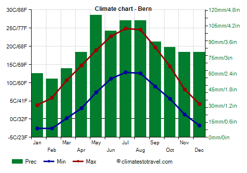
Bern, the capital of Switzerland, lies on the plateau, at 500 meters (1,600 feet) above sea level, and has an average temperature ranging from 0.5 °C (33 °F) in January to 19 °C (66 °F) in July. There are on average 35 days with snowfall per year, usually occurring from November to April.
In Bern, precipitation amounts to about 1,025 mm (40.5 in) per year, well distributed throughout the year, but with a maximum in late spring and in summer due to afternoon thunderstorms.
Zurich
In
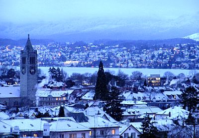
Zurich, 400 meters (1,300 feet) above sea level, the temperatures are similar to that of Bern. The weather in winter is often cold and dull, but there can be some gloomy days even in summer. The rain pattern is also very similar to that of Bern, with 1,100 mm (44 in) per year and a maximum in late spring and summer.
In winter, on anticyclonic periods, when the sun shines in the mountains and in Ticino, a cloud blanket usually forms in Zurich and the cities of the plateau, which are therefore the least sunny of Switzerland.
In
Lucerne too, the average temperature is also around 1 °C (34 °F) in January and around 20 °C (68 °F) in July.
Geneva
Because of its location more to the west and on the shores of the lake of the same name, the climate in
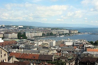
Geneva is a bit less cold in winter, with the average temperature being 2 °C (36 °F) in January and with rarer snowfalls, and a little warmer and sunnier in summer, with an average of 20 °C (68 °F) in July.
The rainfall is lower, especially in summer, and the total is 925 mm (36.5 in) per year.
A similar climate is found in
Lausanne and
Montreux, the other major cities on Lake Geneva. In Montreaux, the summer is usually pleasant, and there is a moderate amount of nice and sunny days.
 Basel
Basel, located at 250 meters (800 ft) above sea level, lies outside the plateau, in the Rhine River Valley, that is, in the climatic area of Central Europe. Since the lower altitude is balanced out by the higher latitude, the climate here is similar to that of cities like Zurich and Bern, and warmer by only 1 degree Celsius (1.8 degree Fahrenheit). Therefore, Basel is cold and gloomy in winter as well, and relatively warm, with possible thunderstorms, in summer.
In contrast, the
Valais is a part of Switzerland with a peculiar microclimate, and in particular, the valley of
Sion: here, precipitation is fairly low, only 585 mm (23 in) per year, because of the orientation of the valley (west-east), which protects it from both cold currents from the north and warm and humid currents from the Mediterranean Sea. On the other hand, during winter, cold air stagnates in the valley, to the point that the average low temperature in January is -3 °C (26.5 °F).
Canton of Ticino
The warmest cities of Switzerland are those of
Ticino, which is located on the southern side of the Alps, and therefore is sheltered from the cold northern wind, as happens in
Locarno, located at 195 meters (640 feet) above sea level on the shores of Lake Maggiore, and Lugano, located at less than 300 meters (1,000 feet) above sea level and tempered by the lake of the same name.
Here, the climate is similar to that of the shores of Lake Como in Italy, and it's relatively mild in winter, when snowfalls and frosts are quite rare, while it's warm but not oppressive in summer.
However, the climate of Ticino is quite
rainy, especially in autumn (when the rains are due to warm air masses from the Ligurian Sea) and in late spring and summer (when they are due to afternoon thunderstorms, which are enhanced by the surrounding mountains, as well as by the waters of the lake). Here, the relatively driest season is winter, from December to February.
Lugano
In
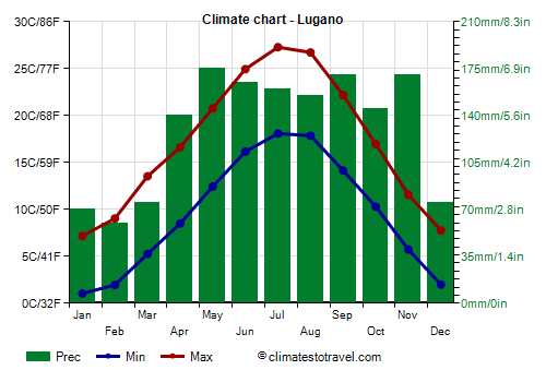
Lugano, the monthly average temperature ranges from 4 °C (39 °F) in January to 22.7 °C (72.8 °F) in July.
The rainfall amounts to 1,570 mm (62 in) per year.
The Alps
In the
mountains, the climate varies with altitude and slope exposure. Most of the country is located on the northern side of the Alps, which has a lower average temperature than the southern side, and therefore a lower snowline.
The weather in the mountains is highly
variable, in fact, it depends, more than in the lowlands, on the nature of the air mass that affects a given area at a given time. So, above 1,500 meters (5,000 feet), during cold spells, it can sometimes snow even in June. On the other hand, on sunny days, the temperature can rise above freezing and become almost mild even in winter.
During the warm season, from May to September, in the mountains, there are frequent thunderstorms in the afternoon or evening.
Zermatt, located in the canton of Valais, at 1,600 meters (5,250 feet) above sea level, has a relatively dry microclimate, in fact, it is sheltered on both the north and south sides by a double chain of mountains, just like the aforementioned Sion, so the annual precipitation is lower than 650 mm (25.5 in). However, in the mountains that surround it, which are high and covered with glaciers, you can ski for most of the year. In Zermatt, the monthly average temperature ranges from -3.5 °C (26 °F) in January to 14 °C (57 °F) in July.
Davos
In
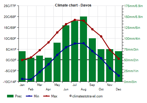
Davos, in the Canton of Grisons, at 1,600 meters (5,250 feet) above sea level, the average temperature ranges from -4.5 °C (24 °F) in January to 13 °C (55.5 °F) in July.
In Davos, summer is definitely the rainiest season because of afternoon thunderstorms.
As mentioned, on anticyclonic periods, the sun shines more often in the mountains than in the plateau and in the valley bottoms. In summer, however, although in the morning the sun often shines, at mid-day and in the afternoon, the sky becomes often cloudy, and thunderstorms can break out.
Wind
Many parts of Switzerland are subject to a warm, dry wind coming down from the mountains: the
Föhn. It blows from the south over a large part of Switzerland, leading to sudden increases in temperature, and it's more frequent in spring and autumn. On the contrary, in the Canton of Ticino, which is on the southern side, the Föhn effect is caused by the north wind, so this area is often relatively warm and dry when the rest of the country is under the grip of cold waves.
Switzerland can also be affected by
windstorms coming from the Atlantic. During the most intense storms, gusts of wind can exceed 100 km/h (62 mph) in the cities of the highlands, and even more so on the mountain ridges. For example, important storms were Vivian, which occurred on February 27, 1990, Lothar, which occurred on December 26, 1999, and Burglind, which occurred in early January 2018.
When to go
The best time to visit Switzerland runs from late spring to early autumn (
May to September).
Late winter and early spring (February-March) are recommended for a
ski holiday, since the days are longer than in December and January. In some resorts located at high altitude, you can ski even in summer.
If you want to go
hiking in the mountains, summer is a good time, although thunderstorms erupt quite frequently in the afternoon.
What to pack
In
winter: pack warm clothes, such as a down jacket, a hat, a scarf, gloves, and a raincoat or umbrella.
In
summer: pack light clothes, T-shirts and shorts, but also long pants, a jacket and a sweater for the evening and for cooler days; a raincoat or umbrella. For the mountains, bring hiking shoes, sunscreen and sunglasses; add warmer clothes for the highest peaks.
Climate data - Switzerland
| Basel (300 meters) |
|---|
|
| Jan | Feb | Mar | Apr | May | Jun | Jul | Aug | Sep | Oct | Nov | Dec |
|---|
| Min temp. | 0 | 0 | 3 | 6 | 10 | 13 | 15 | 15 | 11 | 8 | 3 | 0 |
|---|
| Max temp. | 5 | 7 | 12 | 16 | 20 | 24 | 26 | 25 | 21 | 15 | 9 | 6 |
|---|
| Precip. | 50 | 45 | 50 | 65 | 100 | 85 | 90 | 85 | 70 | 75 | 65 | 65 |
|---|
| Prec. days | 9 | 8 | 9 | 10 | 12 | 10 | 10 | 10 | 8 | 10 | 10 | 11 |
|---|
| Humidity | 84% | 79% | 71% | 67% | 69% | 69% | 68% | 71% | 77% | 83% | 85% | 86% |
|---|
| Day length | 9 | 10 | 12 | 14 | 15 | 16 | 16 | 14 | 12 | 11 | 9 | 8 |
|---|
| Sun hours | 2 | 3 | 4 | 6 | 6 | 7 | 8 | 7 | 6 | 4 | 2 | 2 |
|---|
|
| Bern (550 meters) |
|---|
|
| Jan | Feb | Mar | Apr | May | Jun | Jul | Aug | Sep | Oct | Nov | Dec |
|---|
| Min temp. | -3 | -3 | 0 | 3 | 7 | 11 | 13 | 13 | 9 | 6 | 1 | -2 |
|---|
| Max temp. | 4 | 6 | 11 | 15 | 19 | 23 | 25 | 25 | 20 | 14 | 8 | 4 |
|---|
| Precip. | 60 | 55 | 65 | 80 | 115 | 100 | 110 | 110 | 90 | 85 | 80 | 80 |
|---|
| Prec. days | 10 | 9 | 10 | 10 | 12 | 11 | 11 | 11 | 9 | 10 | 10 | 10 |
|---|
| Humidity | 86% | 79% | 71% | 68% | 69% | 68% | 67% | 71% | 77% | 83% | 87% | 88% |
|---|
| Day length | 9 | 10 | 12 | 14 | 15 | 16 | 15 | 14 | 12 | 11 | 9 | 9 |
|---|
| Sun hours | 2 | 3 | 5 | 6 | 6 | 7 | 8 | 7 | 6 | 4 | 2 | 2 |
|---|
|
| Davos (1,600 meters) |
|---|
|
| Jan | Feb | Mar | Apr | May | Jun | Jul | Aug | Sep | Oct | Nov | Dec |
|---|
| Min temp. | -9 | -9 | -5 | -2 | 2 | 6 | 8 | 8 | 4 | 1 | -4 | -7 |
|---|
| Max temp. | 0 | 1 | 5 | 8 | 13 | 17 | 19 | 18 | 14 | 11 | 5 | 1 |
|---|
| Precip. | 70 | 55 | 60 | 55 | 90 | 130 | 140 | 150 | 100 | 75 | 75 | 70 |
|---|
| Prec. days | 9 | 8 | 9 | 9 | 12 | 14 | 14 | 14 | 10 | 9 | 10 | 10 |
|---|
| Humidity | 68% | 71% | 73% | 79% | 80% | 80% | 78% | 78% | 75% | 69% | 69% | 66% |
|---|
| Day length | 9 | 10 | 12 | 14 | 15 | 16 | 15 | 14 | 12 | 11 | 9 | 9 |
|---|
| Sun hours | 4 | 4 | 5 | 5 | 5 | 6 | 6 | 6 | 5 | 5 | 3 | 3 |
|---|
|
| Freiburg (600 meters) |
|---|
|
| Jan | Feb | Mar | Apr | May | Jun | Jul | Aug | Sep | Oct | Nov | Dec |
|---|
| Min temp. | -3 | -2 | 0 | 3 | 8 | 11 | 13 | 13 | 9 | 6 | 1 | -2 |
|---|
| Max temp. | 4 | 5 | 10 | 14 | 18 | 22 | 24 | 24 | 19 | 14 | 8 | 4 |
|---|
| Precip. | 50 | 50 | 60 | 75 | 110 | 100 | 105 | 105 | 85 | 85 | 70 | 65 |
|---|
| Prec. days | 9 | 8 | 10 | 10 | 12 | 11 | 10 | 11 | 9 | 10 | 10 | 10 |
|---|
|
|
|
|
| Geneva (400 meters) |
|---|
|
| Jan | Feb | Mar | Apr | May | Jun | Jul | Aug | Sep | Oct | Nov | Dec |
|---|
| Min temp. | -1 | -1 | 2 | 5 | 9 | 13 | 15 | 14 | 11 | 7 | 2 | 0 |
|---|
| Max temp. | 5 | 7 | 12 | 16 | 20 | 24 | 27 | 26 | 21 | 16 | 10 | 6 |
|---|
| Precip. | 70 | 55 | 60 | 65 | 75 | 80 | 80 | 80 | 85 | 90 | 90 | 90 |
|---|
| Prec. days | 10 | 8 | 8 | 9 | 10 | 9 | 8 | 8 | 8 | 10 | 10 | 10 |
|---|
| Humidity | 82% | 75% | 68% | 64% | 67% | 64% | 62% | 65% | 73% | 80% | 82% | 83% |
|---|
| Day length | 9 | 10 | 12 | 14 | 15 | 16 | 15 | 14 | 12 | 11 | 9 | 9 |
|---|
| Sun hours | 2 | 4 | 5 | 6 | 7 | 8 | 9 | 8 | 6 | 4 | 2 | 2 |
|---|
|
| Jungfraujoch (3,580 meters) |
|---|
|
| Jan | Feb | Mar | Apr | May | Jun | Jul | Aug | Sep | Oct | Nov | Dec |
|---|
| Min temp. | -16 | -16 | -14 | -12 | -8 | -4 | -2 | -2 | -5 | -7 | -12 | -14 |
|---|
| Max temp. | -10 | -10 | -9 | -6 | -2 | 2 | 3 | 4 | 0 | -2 | -6 | -9 |
|---|
|
|
|
| Sun hours | 4 | 4 | 5 | 5 | 5 | 6 | 6 | 6 | 6 | 5 | 4 | 3 |
|---|
|
| Kreuzlingen (400 meters) |
|---|
|
| Jan | Feb | Mar | Apr | May | Jun | Jul | Aug | Sep | Oct | Nov | Dec |
|---|
| Min temp. | -1 | -1 | 2 | 5 | 10 | 13 | 15 | 15 | 11 | 7 | 3 | 0 |
|---|
| Max temp. | 4 | 6 | 11 | 16 | 20 | 24 | 26 | 25 | 20 | 15 | 8 | 4 |
|---|
| Precip. | 45 | 45 | 50 | 60 | 90 | 100 | 95 | 95 | 70 | 60 | 60 | 65 |
|---|
| Prec. days | 9 | 9 | 9 | 9 | 10 | 11 | 12 | 11 | 9 | 9 | 9 | 11 |
|---|
| Humidity | 84% | 82% | 76% | 64% | 63% | 68% | 69% | 64% | 75% | 82% | 87% | 87% |
|---|
| Day length | 9 | 10 | 12 | 14 | 15 | 16 | 16 | 14 | 12 | 11 | 9 | 8 |
|---|
| Sun hours | 2 | 3 | 5 | 6 | 7 | 8 | 8 | 8 | 6 | 3 | 2 | 1 |
|---|
|
| La Brévine (1,045 meters) |
|---|
|
| Jan | Feb | Mar | Apr | May | Jun | Jul | Aug | Sep | Oct | Nov | Dec |
|---|
| Min temp. | -9 | -10 | -5 | -2 | 2 | 5 | 7 | 6 | 3 | 1 | -4 | -8 |
|---|
| Max temp. | 1 | 2 | 6 | 11 | 15 | 19 | 21 | 21 | 16 | 12 | 6 | 2 |
|---|
| Precip. | 85 | 80 | 85 | 95 | 130 | 120 | 130 | 120 | 115 | 115 | 110 | 115 |
|---|
| Prec. days | 12 | 11 | 11 | 12 | 14 | 12 | 12 | 11 | 11 | 12 | 12 | 13 |
|---|
|
|
|
|
| Lausanne (525 meters) |
|---|
|
| Jan | Feb | Mar | Apr | May | Jun | Jul | Aug | Sep | Oct | Nov | Dec |
|---|
| Min temp. | 1 | 1 | 4 | 7 | 11 | 14 | 16 | 16 | 13 | 9 | 4 | 2 |
|---|
| Max temp. | 5 | 6 | 10 | 15 | 19 | 23 | 25 | 24 | 20 | 15 | 9 | 5 |
|---|
| Precip. | 75 | 65 | 70 | 85 | 115 | 105 | 105 | 110 | 100 | 110 | 100 | 100 |
|---|
| Prec. days | 10 | 8 | 9 | 9 | 12 | 10 | 10 | 10 | 9 | 10 | 10 | 11 |
|---|
|
|
| Sun hours | 2 | 4 | 5 | 6 | 7 | 8 | 8 | 8 | 6 | 4 | 3 | 2 |
|---|
|
| Locarno |
|---|
|
| Jan | Feb | Mar | Apr | May | Jun | Jul | Aug | Sep | Oct | Nov | Dec |
|---|
| Min temp. | 1 | 2 | 5 | 8 | 12 | 16 | 18 | 17 | 14 | 10 | 5 | 2 |
|---|
| Max temp. | 7 | 9 | 14 | 17 | 21 | 25 | 27 | 27 | 22 | 17 | 11 | 8 |
|---|
| Precip. | 70 | 65 | 95 | 165 | 185 | 180 | 165 | 205 | 190 | 200 | 210 | 85 |
|---|
| Prec. days | 5 | 4 | 6 | 10 | 11 | 10 | 9 | 10 | 9 | 9 | 10 | 6 |
|---|
| Humidity | 69% | 73% | 71% | 76% | 78% | 77% | 76% | 78% | 80% | 78% | 75% | 70% |
|---|
| Day length | 9 | 10 | 12 | 14 | 15 | 16 | 15 | 14 | 12 | 11 | 9 | 9 |
|---|
| Sun hours | 4 | 5 | 6 | 6 | 7 | 8 | 9 | 8 | 7 | 5 | 4 | 4 |
|---|
|
| Lucerne (435 meters) |
|---|
|
| Jan | Feb | Mar | Apr | May | Jun | Jul | Aug | Sep | Oct | Nov | Dec |
|---|
| Min temp. | -2 | -2 | 2 | 5 | 9 | 13 | 15 | 14 | 11 | 7 | 2 | -1 |
|---|
| Max temp. | 4 | 6 | 11 | 15 | 19 | 23 | 25 | 24 | 20 | 14 | 8 | 5 |
|---|
| Precip. | 55 | 60 | 70 | 95 | 140 | 155 | 155 | 160 | 105 | 85 | 75 | 75 |
|---|
| Prec. days | 10 | 8 | 11 | 11 | 13 | 13 | 13 | 13 | 10 | 10 | 10 | 10 |
|---|
| Humidity | 82% | 78% | 73% | 71% | 73% | 73% | 72% | 76% | 79% | 82% | 82% | 82% |
|---|
| Day length | 9 | 10 | 12 | 14 | 15 | 16 | 15 | 14 | 12 | 11 | 9 | 9 |
|---|
| Sun hours | 2 | 3 | 4 | 5 | 6 | 6 | 7 | 6 | 5 | 3 | 2 | 1 |
|---|
|
| Lugano (270 meters) |
|---|
|
| Jan | Feb | Mar | Apr | May | Jun | Jul | Aug | Sep | Oct | Nov | Dec |
|---|
| Min temp. | 1 | 2 | 5 | 9 | 12 | 16 | 18 | 18 | 14 | 10 | 6 | 2 |
|---|
| Max temp. | 7 | 9 | 14 | 17 | 21 | 25 | 27 | 27 | 22 | 17 | 12 | 8 |
|---|
| Precip. | 70 | 60 | 75 | 140 | 175 | 165 | 160 | 155 | 170 | 145 | 170 | 75 |
|---|
| Prec. days | 6 | 5 | 6 | 10 | 12 | 10 | 8 | 10 | 9 | 9 | 10 | 6 |
|---|
| Humidity | 74% | 66% | 60% | 63% | 67% | 66% | 64% | 68% | 73% | 80% | 77% | 76% |
|---|
| Day length | 9 | 10 | 12 | 14 | 15 | 16 | 15 | 14 | 12 | 11 | 9 | 9 |
|---|
| Sun hours | 4 | 5 | 6 | 6 | 6 | 8 | 8 | 8 | 6 | 5 | 4 | 4 |
|---|
|
| Neuchâtel (430 meters) |
|---|
|
| Jan | Feb | Mar | Apr | May | Jun | Jul | Aug | Sep | Oct | Nov | Dec |
|---|
| Min temp. | 0 | 0 | 3 | 6 | 10 | 14 | 16 | 15 | 12 | 8 | 4 | 1 |
|---|
| Max temp. | 4 | 6 | 11 | 15 | 19 | 23 | 25 | 25 | 20 | 14 | 8 | 5 |
|---|
| Precip. | 70 | 60 | 65 | 70 | 85 | 85 | 95 | 100 | 80 | 85 | 80 | 90 |
|---|
| Prec. days | 10 | 9 | 9 | 9 | 12 | 10 | 10 | 10 | 8 | 10 | 10 | 10 |
|---|
| Humidity | 81% | 75% | 67% | 63% | 66% | 65% | 63% | 66% | 72% | 80% | 82% | 83% |
|---|
| Day length | 9 | 10 | 12 | 14 | 15 | 16 | 15 | 14 | 12 | 11 | 9 | 9 |
|---|
| Sun hours | 2 | 3 | 5 | 6 | 6 | 8 | 8 | 8 | 6 | 3 | 2 | 1 |
|---|
|
| Saentis (2,500 meters) |
|---|
|
| Jan | Feb | Mar | Apr | May | Jun | Jul | Aug | Sep | Oct | Nov | Dec |
|---|
| Min temp. | -9 | -10 | -8 | -5 | -1 | 2 | 4 | 4 | 1 | -1 | -6 | -8 |
|---|
| Max temp. | -4 | -5 | -3 | -1 | 3 | 7 | 9 | 10 | 6 | 4 | -1 | -3 |
|---|
| Precip. | 135 | 140 | 135 | 95 | 65 | 30 | 15 | 10 | 40 | 60 | 120 | 165 |
|---|
| Prec. days | 13 | 12 | 14 | 13 | 15 | 16 | 16 | 16 | 13 | 12 | 12 | 15 |
|---|
|
|
| Sun hours | 4 | 5 | 5 | 5 | 5 | 5 | 5 | 6 | 5 | 5 | 4 | 4 |
|---|
|
| Samedan (1,705 meters) |
|---|
|
| Jan | Feb | Mar | Apr | May | Jun | Jul | Aug | Sep | Oct | Nov | Dec |
|---|
| Min temp. | -16 | -16 | -10 | -4 | 0 | 3 | 5 | 5 | 1 | -3 | -8 | -13 |
|---|
| Max temp. | -1 | 0 | 4 | 8 | 13 | 17 | 19 | 19 | 15 | 10 | 4 | -1 |
|---|
| Precip. | 30 | 20 | 25 | 35 | 65 | 90 | 85 | 100 | 75 | 75 | 70 | 35 |
|---|
| Prec. days | 5 | 4 | 4 | 6 | 9 | 11 | 11 | 11 | 8 | 8 | 8 | 6 |
|---|
|
|
| Sun hours | 4 | 4 | 5 | 5 | 5 | 6 | 6 | 6 | 5 | 4 | 3 | 3 |
|---|
|
| Sion (490 meters) |
|---|
|
| Jan | Feb | Mar | Apr | May | Jun | Jul | Aug | Sep | Oct | Nov | Dec |
|---|
| Min temp. | -3 | -2 | 2 | 5 | 9 | 13 | 14 | 14 | 10 | 6 | 1 | -3 |
|---|
| Max temp. | 5 | 8 | 14 | 18 | 22 | 26 | 27 | 26 | 22 | 17 | 10 | 5 |
|---|
| Precip. | 50 | 40 | 35 | 35 | 50 | 50 | 65 | 60 | 40 | 40 | 50 | 70 |
|---|
| Prec. days | 7 | 6 | 6 | 5 | 8 | 7 | 8 | 8 | 6 | 6 | 7 | 8 |
|---|
| Humidity | 77% | 69% | 60% | 56% | 60% | 60% | 61% | 64% | 69% | 74% | 76% | 80% |
|---|
| Day length | 9 | 10 | 12 | 14 | 15 | 16 | 15 | 14 | 12 | 11 | 9 | 9 |
|---|
| Sun hours | 3 | 5 | 6 | 7 | 7 | 8 | 9 | 8 | 7 | 5 | 3 | 2 |
|---|
|
| St Gallen (650 meters) |
|---|
|
| Jan | Feb | Mar | Apr | May | Jun | Jul | Aug | Sep | Oct | Nov | Dec |
|---|
| Min temp. | -2 | -2 | 1 | 4 | 8 | 12 | 14 | 14 | 10 | 6 | 2 | -2 |
|---|
| Max temp. | 3 | 4 | 8 | 12 | 16 | 20 | 22 | 21 | 17 | 12 | 7 | 4 |
|---|
| Precip. | 65 | 65 | 85 | 105 | 155 | 170 | 175 | 185 | 140 | 105 | 95 | 90 |
|---|
| Prec. days | 11 | 9 | 12 | 11 | 14 | 14 | 13 | 13 | 12 | 10 | 10 | 12 |
|---|
|
|
| Sun hours | 2 | 3 | 4 | 6 | 6 | 7 | 7 | 7 | 5 | 3 | 2 | 2 |
|---|
|
| Zermatt (1,600 meters) |
|---|
|
| Jan | Feb | Mar | Apr | May | Jun | Jul | Aug | Sep | Oct | Nov | Dec |
|---|
| Min temp. | -7 | -7 | -4 | -1 | 3 | 7 | 8 | 8 | 5 | 1 | -3 | -6 |
|---|
| Max temp. | 1 | 2 | 6 | 10 | 14 | 18 | 20 | 20 | 15 | 11 | 5 | 2 |
|---|
| Precip. | 40 | 30 | 35 | 40 | 75 | 70 | 60 | 70 | 50 | 55 | 65 | 45 |
|---|
| Prec. days | 6 | 6 | 5 | 6 | 10 | 10 | 9 | 10 | 7 | 7 | 7 | 7 |
|---|
|
|
| Sun hours | 3 | 4 | 5 | 5 | 5 | 6 | 6 | 6 | 5 | 4 | 3 | 3 |
|---|
|
| Zurich (550 meters) |
|---|
|
| Jan | Feb | Mar | Apr | May | Jun | Jul | Aug | Sep | Oct | Nov | Dec |
|---|
| Min temp. | -1 | -1 | 2 | 5 | 9 | 13 | 14 | 14 | 11 | 7 | 3 | 0 |
|---|
| Max temp. | 3 | 5 | 10 | 15 | 19 | 22 | 24 | 24 | 19 | 14 | 8 | 4 |
|---|
| Precip. | 60 | 60 | 70 | 80 | 130 | 125 | 130 | 120 | 90 | 85 | 80 | 85 |
|---|
| Prec. days | 10 | 9 | 10 | 11 | 13 | 12 | 12 | 12 | 10 | 10 | 10 | 11 |
|---|
| Humidity | 84% | 79% | 72% | 67% | 70% | 70% | 69% | 73% | 78% | 85% | 87% | 86% |
|---|
| Day length | 9 | 10 | 12 | 14 | 15 | 16 | 16 | 14 | 12 | 11 | 9 | 8 |
|---|
| Sun hours | 2 | 3 | 5 | 6 | 6 | 7 | 7 | 7 | 5 | 4 | 2 | 2 |
|---|
|
See also the
temperatures month by month