Select units of measurement for the temperature and rainfall tables (metric or imperial).
Average weather, temperature, rainfall, sunshine hours

The climate of Geneva is
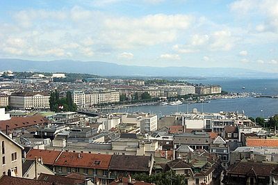
moderately continental, with cold winters and warm summers. The city is located at 400 meters (1,300 feet) above sea level, on the shores of the lake of the same name.
The daily average
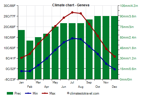
temperature ranges from 2 °C (35.5 °F) in January to 20.5 °C (69 °F) in July.
Precipitation amounts to 925 millimeters (36.5 inches) per year and is well distributed over the seasons: in the cold half of the year, it is due to Atlantic depressions, whereas in summer, when Atlantic depressions become a little rarer, thunderstorms can break out in the afternoon.
 Winter
, from December to February, is cold: temperatures are often around freezing (0 °C or 32 °F), and there are many gray days. The wind is quite frequent as well, and there are noticeable changes in temperature.
In fact, the city can be reached by Atlantic depressions, which bring wet and rainy weather, though relatively mild: in these cases, the maximum temperature can reach or exceed 10/12 °C (50/54 °F).
However, the city can also be reached by
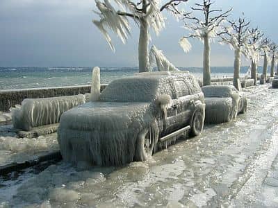
cold air masses of Siberian origin, brought by a cold wind from the northeast, the
Bise. This wind can make the lake choppy, and sprayed water can freeze, creating an unusual layer of ice on boats, on docks and on the lakefront. Under the influence of the
Bise, the temperature may remain below freezing all day, and the wind heightens the feeling of cold, making it seem polar.
The temperature rarely drops below -10 °C (14 °F). However, in the past, it reached lower values. The coldest record is -20 °C (-4 °F) and was set in February 1956 and in January 1968.
Snowfall amounts to around 30 cm (12.5 inches) per year, and can occur during cold air outbreaks, and also later, when the westerlies begin to blow again: in the latter case, the snow is going to melt with the passing of hours, when the mild air mass takes over.
Spring, from March to May, is initially a bit cold, and then gradually becomes milder. In March, snow and frost can still occur, and sometimes, also in the first half of April. Typically, the temperature becomes pleasant in a more stable manner by the second half of May, when the first afternoon thunderstorms can also erupt.
Summer, from June to August, is warm and sunny, though with cool nights, and the breeze blowing from the lake. The Azores High is able to bring periods of good weather, sometimes even long, during which thunderstorms can break out in the afternoon (but less frequently than in other cities of Switzerland).
Very hot days are quite rare, however, in recent decades, due to global warming, they have become more frequent. The highest record is 39.7 °C (103.5 °F) and was set in July 2015. In 2022, the temperature reached 35.5 °C (96 °F) in June, 38.1 °C (100.6 °F) in July and 38.3 °C (100.9 °F) in August.
At other times, Atlantic fronts can affect this area, bringing a bit of rain and cool weather. Sometimes at night, it can get even a little cold: the minimum temperature can drop below 10 °C (50 °F) even in July and August.
Autumn, from September to November, is quite rainy; temperatures are initially pleasant, and then become gradually colder. November is usually a cold and dull month.

The amount of
sunshine in Geneva is good in summer, when the sun shines quite often, while it is low from November to February, when the sun is seen quite rarely. In one year, 1,930 hours of sunshine are recorded (slightly more than in other cities of the Swiss plateau. For example, Zurich has 1,680 hours, and Bern 1,790).
Best Time
The
best time to visit Geneva is from mid-May to mid-September, since it is the warmest and sunniest of the year. However, we cannot exclude some rain, or a bit of cool weather, or even cold, especially in May and early June.
Geneva - Climate data
In Geneva, the
average temperature of the coldest month (January) is of
2.1 °C, that of the warmest month (July) is of
20.7 °C. Here are the average temperatures.
Geneva - Average temperatures (1991-2020) |
| Month | Min | Max | Mean |
|---|
| January | -1.1 | 5.3 | 2.1 |
|---|
| February | -1.1 | 7.2 | 3 |
|---|
| March | 1.8 | 12 | 6.9 |
|---|
| April | 5 | 16.1 | 10.5 |
|---|
| May | 9 | 20.3 | 14.6 |
|---|
| June | 12.6 | 24.3 | 18.5 |
|---|
| July | 14.5 | 26.8 | 20.7 |
|---|
| August | 14.1 | 26.3 | 20.2 |
|---|
| September | 10.7 | 21.2 | 16 |
|---|
| October | 7.1 | 15.7 | 11.4 |
|---|
| November | 2.5 | 9.5 | 6 |
|---|
| December | -0.2 | 5.9 | 2.8 |
|---|
| Year | 6.3 | 15.9 | 11.1 |
|---|
amounts to
925 millimeters per year: so, it is at an intermediate level. It ranges from
55 millimeters in the driest month (February) to
90 millimeters in the wettest ones (October, November, December) Here is the average precipitation.
Geneva - Average precipitation| Month | Days |
|---|
| January | 70 | 10 |
|---|
| February | 55 | 8 |
|---|
| March | 60 | 8 |
|---|
| April | 65 | 9 |
|---|
| May | 75 | 10 |
|---|
| June | 80 | 9 |
|---|
| July | 80 | 8 |
|---|
| August | 80 | 8 |
|---|
| September | 85 | 8 |
|---|
| October | 90 | 10 |
|---|
| November | 90 | 10 |
|---|
| December | 90 | 10 |
|---|
| Year | 925 | 108 |
|---|
There are on average around 1930
sunshine hours per year. Here are the average hours of sunshine per day.
Geneva - Sunshine hours| Month | Average | Total |
|---|
| January | 2 | 65 |
|---|
| February | 3.5 | 100 |
|---|
| March | 5.5 | 165 |
|---|
| April | 6.5 | 190 |
|---|
| May | 7 | 215 |
|---|
| June | 8.5 | 250 |
|---|
| July | 8.5 | 270 |
|---|
| August | 8 | 245 |
|---|
| September | 6.5 | 190 |
|---|
| October | 4 | 120 |
|---|
| November | 2.5 | 70 |
|---|
| December | 1.5 | 50 |
|---|
| Year | 5.3 | 1930 |
|---|
Geneva - Weather by month
Based on the period 1991-2020
January, the coldest month of the year, is generally a cold month. The average temperature is of
2.1 °C, with a minimum of
-1.1 °C and a maximum of
5.3 °C.

On the coldest nights of the month, the temperature usually drops to around
-7 °C. However, it dropped to
-11.2 °C in January 2007.

On the warmest days of the month, the temperature usually reaches around
12.5 °C. However, it reached
17 °C in January 2015.

Precipitation amounts to
70 mm, distributed over 10 days.
The day lasts on average 9 hours and 5 minutes.

There are on average 2 hours of sunshine per day. So, the sun shines 23% of the time.
The average humidity is 82%. Hence, the air is normally humid.
The average wind speed is of
8.4 kph.
February is generally a cold month. The average temperature is of
3 °C, with a minimum of
-1.1 °C and a maximum of
7.2 °C.

On the coldest nights of the month, the temperature usually drops to around
-6.5 °C. However, it dropped to
-11.2 °C in February 2012.

On the warmest days of the month, the temperature usually reaches around
14.5 °C. However, it reached
20.1 °C in February 2019.

Precipitation amounts to
55 mm, distributed over 8 days.
The day lasts on average 10 hours and 25 minutes.

There are on average 3.5 hours of sunshine per day. So, the sun shines 35% of the time.
The average humidity is 75%. Hence, the air is normally humid.
The average wind speed is of
9.1 kph.
March is generally a quite mild month. The average temperature is of
6.9 °C, with a minimum of
1.8 °C and a maximum of
12 °C.

On the coldest nights of the month, the temperature usually drops to around
-4 °C. However, it dropped to
-10 °C in March 2005.

On the warmest days of the month, the temperature usually reaches around
20 °C. However, it reached
23 °C in March 2006.

Precipitation amounts to
60 mm, distributed over 8 days.
The day lasts on average 12 hours and 0 minutes.

There are on average 5.5 hours of sunshine per day. So, the sun shines 45% of the time.
The average humidity is 68%.
The average wind speed is of
9.6 kph.
April is generally a mild month. The average temperature is of
10.5 °C, with a minimum of
5 °C and a maximum of
16.1 °C.

On the coldest nights of the month, the temperature usually drops to around
-1 °C. However, it dropped to
-4 °C in April 2003.

On the warmest days of the month, the temperature usually reaches around
24 °C. However, it reached
27.5 °C in April 2018.

Precipitation amounts to
65 mm, distributed over 9 days.
The day lasts on average 13 hours and 35 minutes.

There are on average 6.5 hours of sunshine per day. So, the sun shines 47% of the time.
The average humidity is 64%.
The average wind speed is of
9.3 kph.
May is generally a very mild month. The average temperature is of
14.6 °C, with a minimum of
9 °C and a maximum of
20.3 °C.

On the coldest nights of the month, the temperature usually drops to around
3 °C. However, it dropped to
-0.6 °C in May 1991.

On the warmest days of the month, the temperature usually reaches around
28 °C. However, it reached
33.8 °C in May 2009.

Precipitation amounts to
75 mm, distributed over 10 days.
The day lasts on average 15 hours and 0 minutes. So the days are long.

There are on average 7 hours of sunshine per day. So, the sun shines 46% of the time.
The average humidity is 67%.
The average wind speed is of
8.6 kph.
June is generally a warm month. The average temperature is of
18.5 °C, with a minimum of
12.6 °C and a maximum of
24.3 °C.

On the coldest nights of the month, the temperature usually drops to around
7 °C. However, it dropped to
3 °C in June 2001.

On the warmest days of the month, the temperature usually reaches around
32 °C. However, it reached
36.5 °C in June 2003.

Precipitation amounts to
80 mm, distributed over 9 days.
The day lasts on average 15 hours and 40 minutes. So the days are long. June 21, the summer solstice, is the longest day of the year in the Northern Hemisphere.

There are on average 8.5 hours of sunshine per day. So, the sun shines 53% of the time.
The average humidity is 64%.
The average wind speed is of
8.2 kph.
July, the warmest month of the year, is generally a warm month. The average temperature is of
20.7 °C, with a minimum of
14.5 °C and a maximum of
26.8 °C.

On the coldest nights of the month, the temperature usually drops to around
9 °C. However, it dropped to
6 °C in July 2000.

On the warmest days of the month, the temperature usually reaches around
33.5 °C. However, it reached
39.7 °C in July 2015.

Precipitation amounts to
80 mm, distributed over 8 days.
The day lasts on average 15 hours and 20 minutes. So the days are long.

There are on average 8.5 hours of sunshine per day. So, the sun shines 57% of the time.
The average humidity is 62%.
The average wind speed is of
7.7 kph.
August is generally a warm month. The average temperature is of
20.2 °C, with a minimum of
14.1 °C and a maximum of
26.3 °C.

On the coldest nights of the month, the temperature usually drops to around
8.5 °C. However, it dropped to
5.9 °C in August 1993.

On the warmest days of the month, the temperature usually reaches around
33 °C. However, it reached
38 °C in August 2003.

Precipitation amounts to
80 mm, distributed over 8 days.
The day lasts on average 14 hours and 5 minutes. So the days are long.

There are on average 8 hours of sunshine per day. So, the sun shines 56% of the time.
The average humidity is 65%.
The average wind speed is of
6.9 kph.
September is generally a very mild month. The average temperature is of
16 °C, with a minimum of
10.7 °C and a maximum of
21.2 °C.

On the coldest nights of the month, the temperature usually drops to around
4.5 °C. However, it dropped to
1 °C in September 1995.

On the warmest days of the month, the temperature usually reaches around
28 °C. However, it reached
31.4 °C in September 2018.

Precipitation amounts to
85 mm, distributed over 8 days.
The day lasts on average 12 hours and 30 minutes.

There are on average 6.5 hours of sunshine per day. So, the sun shines 50% of the time.
The average humidity is 73%. Hence, the air is normally humid.
The average wind speed is of
7.2 kph.
October is generally a mild month. The average temperature is of
11.4 °C, with a minimum of
7.1 °C and a maximum of
15.7 °C.

On the coldest nights of the month, the temperature usually drops to around
1 °C. However, it dropped to
-5 °C in October 1997.

On the warmest days of the month, the temperature usually reaches around
22.5 °C. However, it reached
27 °C in October 2009.

Precipitation amounts to
90 mm, distributed over 10 days.
The day lasts on average 10 hours and 55 minutes.

There are on average 4 hours of sunshine per day. So, the sun shines 36% of the time.
The average humidity is 80%. Hence, the air is normally humid.
The average wind speed is of
7 kph.
November is generally a quite cold month. The average temperature is of
6 °C, with a minimum of
2.5 °C and a maximum of
9.5 °C.

On the coldest nights of the month, the temperature usually drops to around
-3.5 °C. However, it dropped to
-9.2 °C in November 2010.

On the warmest days of the month, the temperature usually reaches around
17 °C. However, it reached
22.1 °C in November 2020.

Precipitation amounts to
90 mm, distributed over 10 days.
The day lasts on average 9 hours and 25 minutes.

There are on average 2.5 hours of sunshine per day. So, the sun shines 24% of the time.
The average humidity is 82%. Hence, the air is normally humid.
The average wind speed is of
7.7 kph.
December is generally a cold month. The average temperature is of
2.8 °C, with a minimum of
-0.2 °C and a maximum of
5.9 °C.

On the coldest nights of the month, the temperature usually drops to around
-6 °C. However, it dropped to
-12.5 °C in December 2009.

On the warmest days of the month, the temperature usually reaches around
12.5 °C. However, it reached
16 °C in December 2011.

Precipitation amounts to
90 mm, distributed over 10 days.
The day lasts on average 8 hours and 40 minutes. December 21, the winter solstice, is the shortest day of the year in the Northern Hemisphere.

There are on average 1.5 hours of sunshine per day. So, the sun shines 18% of the time.
The average humidity is 83%. Hence, the air is normally humid.
The average wind speed is of
8.7 kph.