Select units of measurement for the temperature and rainfall tables (metric or imperial).
Average weather, temperature, rainfall, sunshine hours
In the Marche, a region of central Italy, overlooking the Adriatic Sea and crossed by the Apennines in the western part, we have the following climatic zones:
- the climate of the
coast and of the hills parallel to it, semi-continental in the northernmost part (see Pesaro) and transitional Mediterranean in the central-southern part (from Ancona southwards).
- the climate of the
Apennines, generally temperate humid, but also cold in the mountains at the highest altitudes.
Plains and hills

In winter,
temperatures are lower than on the Tyrrhenian side, in Tuscany.
Summer is hot and sunny, with the breeze blowing from the sea, and some thunderstorms that can come from the Apennines. In inland areas at low altitudes (see Jesi, Macerata, Ascoli Piceno), where the influence of the sea is lower, it can get very hot more easily than the coast.
In
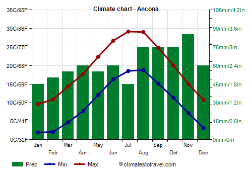
Ancona, the capital, located on the coast, the average temperature ranges from 6 °C (43 °F) in January to 24 °C (75 °F) in July and August. Here are the average temperatures.
Ancona - Average temperatures (1991-2020) |
| Month | Min | Max | Mean |
|---|
| January | 2 | 9.6 | 5.8 |
|---|
| February | 2.1 | 10.9 | 6.5 |
|---|
| March | 4.7 | 14.4 | 9.5 |
|---|
| April | 7.7 | 17.8 | 12.8 |
|---|
| May | 12.1 | 22.4 | 17.2 |
|---|
| June | 16.3 | 26.7 | 21.5 |
|---|
| July | 18.5 | 29.2 | 23.9 |
|---|
| August | 18.8 | 29.1 | 23.9 |
|---|
| September | 15.1 | 24.8 | 20 |
|---|
| October | 11.3 | 20.1 | 15.7 |
|---|
| November | 7.2 | 15 | 11.1 |
|---|
| December | 3.2 | 10.7 | 6.9 |
|---|
| Year | 10 | 19.3 | 14.6 |
|---|
in the Marches is generally moderate, and lower than those of Tuscany, which is located on the Tyrrhenian side and receives humid winds from the west and south-west. On the coast, the least rainy area is the southern one (see S. Benedetto del Tronto and Porto d'Ascoli), where 700 millimeters (27.5 in) fall per year, while in the central-northern part of the coast (see Pesaro, Ancona) it reaches 740 mm (29 in) per year.
In hilly areas, it generally ranges from 800 to 1,000 mm (31 to 40 in) per year. In the mountains, but also on the hills north of the mountains, the climate is more humid, and precipitation can exceed 1,500 mm (59 in) a year.
Here is the average precipitation in Ancona.
Ancona - Average precipitation| Month | Days |
|---|
| January | 45 | 7 |
|---|
| February | 50 | 7 |
|---|
| March | 55 | 8 |
|---|
| April | 60 | 8 |
|---|
| May | 55 | 7 |
|---|
| June | 60 | 6 |
|---|
| July | 45 | 4 |
|---|
| August | 75 | 5 |
|---|
| September | 75 | 7 |
|---|
| October | 75 | 8 |
|---|
| November | 85 | 9 |
|---|
| December | 60 | 7 |
|---|
| Year | 740 | 83 |
|---|
The Marche region is exposed to the
cold wind from the north-east, coming from Eastern Europe, which can bring heavy snowfalls in winter, especially on the hills and mountains, after being loaded with moisture from the sea.
A particularly snowy area is
Montefeltro (see
Urbino, Carpegna), a historic region that also includes San Marino and the mountains of the provinces of Rimini (in Emilia-Romagna) and Arezzo (in Tuscany). In some situations, with the north-easterly currents persisting for several days (such as in January 2005 and February 2012), there were
spectacular snowfalls (from 3 to 5 metres - 120 to 195 inches). Other very snowy areas are the one north of
Monte Catria (see Cagli, Frontone, Serra Sant'Abbondio, in the province of Pesaro-Urbino) and the one north of the
Sibillini mountains (see Bolognola, in the province of Macerata).
In the center-north, cold records are around -15 °C (5 °F) even on the coast (see Pesaro, Ancona).

In addition to the cold wind, the Marches are exposed to the Garbino, the
warm wind from the south-west, which, already mild or hot in origin (it comes from the Mediterranean or North Africa), warms up further as it descends from the mountains due to compression.
This wind can bring temperatures of 20 °C (68 °F) in the middle of winter. In summer there can be
heat waves, which are becoming more frequent due to global warming. The hottest days are recorded with the Garbino, which neutralizes the sea breeze. In the north (see Pesaro, Urbino), the records are of 39 °C (102 °F), while in the centre-south they exceed 40 °C (104 °F).
With global warming, cold waves are becoming rarer and warm periods more frequent, so that the climate of the coastal area, but also of the sub-coastal hilly area, is increasingly taking on Mediterranean characteristics.
Mountains
The highest peak of the Marches is
Monte Vettore, belonging to the Sibillini mountains, 2,476 meters (8,123 ft) high. The Sibillini mountains are protected in a national park.
In the area there are also ski resorts (see Ussita, Castelsantangelo sul Nera, which were unfortunately damaged by the 2016 earthquake). You can also ski in other areas (Forca Canapine, Monte Piselli, Monte Catria), however, there is not always snow on the slopes.
In
Forca Canapine, a pass at 1,540 meters (5,053 ft) on the border with Umbria, the average temperature ranges from -1.5 °C (29 °F) in January to 16 °C (61 °F) in July and August.
Forca Canapine - Average temperatures (2014-2022) |
| Month | Min | Max | Mean |
|---|
| January | -3.5 | 0.8 | -1.3 |
|---|
| February | -2 | 2.6 | 0.3 |
|---|
| March | -1.4 | 3.6 | 1.1 |
|---|
| April | 1.8 | 7.5 | 4.7 |
|---|
| May | 5.3 | 11 | 8.1 |
|---|
| June | 10.6 | 16.2 | 13.4 |
|---|
| July | 13 | 19.3 | 16.2 |
|---|
| August | 13 | 19.5 | 16.2 |
|---|
| September | 8.7 | 14.3 | 11.5 |
|---|
| October | 5.7 | 10.7 | 8.2 |
|---|
| November | 2 | 6.2 | 4.1 |
|---|
| December | -1 | 3.4 | 1.2 |
|---|
| Year | 4.4 | 9.6 | 7 |
|---|
Best Time
For a beach holiday along the Marche coast, the best period is the summer, especially in July and August, since they are the warmest and sunniest months, and when the sea is also warmer.
To visit the cities, given that it can be very hot in summer, you can choose the periods from mid-April to mid-June and from September to early October. In June, the weather is often nice, but sometimes it can get very hot, especially in the second half of the month.
See also the
temperatures by month.