Select units of measurement for the temperature and rainfall tables (metric or imperial).
Average weather, temperature, rainfall, sunshine hours
Campania is a region of southern Italy, facing the Tyrrhenian Sea to the west and crossed by the southern Apennines in the central part, while the eastern part is occupied by hills that are part of the eastern (Adriatic) side.
The climate in Campania is
Mediterranean on the coast (with mild, rainy winters and hot, sunny summers), while it is more more cold, rainy and windy in the mountains, and slightly continental in the eastern part.
In the cold semester,
periods of bad weather due to humid currents of Atlantic or Mediterranean origin, in which the mild sirocco and libeccio winds blow and there may be rain and thunderstorms, alternate with periods of good weather, in which it can get a bit cold at night but the days are mild and sunny.
There are also situations with the north wind, the
tramontana, which brings cold days, with possible rainfall, to the lowland areas, while it can snow in the Apennines.
In summer,
high pressure of subtropical or African origin generally prevails, and therefore the weather is generally nice. However, In the afternoon, thunderstorms can break out in the Apennines, which can sometimes reach the plains.
Campania is a fairly rainy region.
Precipitation is abundant in the Apennines, especially on the western side, where it generally exceeds 1,500 millimeters (60 inches) per year, and in some cases even 2,000 mm (78 in) (see Matese massif, Partenio mountains), but it is also quite abundant in the plains and hills at the foot of the mountains (see Salerno and the Amalfi coast, Avellino), where it exceeds 1,200 mm (47 in) per year.
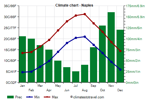
In the plain or hilly areas at a certain distance from the mountains, rainfall is moderate, and generally ranges from 800 to 1,000 mm (31 to 39 in) per year (see Naples), but in the islands (see Capri) it even drops below 700 mm (27.5 in).
In the eastern part of the region, east of the mountains and away from the sea, towards the border with Puglia, rainfall is more limited, dropping to 600 mm (23.5 in).
The rainiest season is generally autumn, when there can be
abundant rains, which can cause the overflowing of rivers. This can happen in October and November, but sometimes also in December, which often takes on autumnal characteristics, especially in the first part.
Campania is a
sunny region, especially on the coast and in the vicinity, where there are over 2,500 hours of sunshine a year.
Plains and hills
As mentioned, on the coast and in the plains located nearby (see Naples, the islands,
Caserta,
Salerno), the climate is
Mediterranean, with mild, rainy winters, and hot, sunny summers.
 Naples
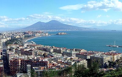
, the regional capital, is located on the coast of the homonymous gulf, although in the northern part there are neighborhoods perched on the hills (Camaldoli, Capodimonte), which are located between 200 and 250 meters (650 and 800 feet), but reach up to 400 meters (1,300 ft).
At Capodichino airport, located in the flat part, the average temperature ranges from 9 °C in January to 26 °C in August. Here are the average temperatures.
Naples - Average temperatures (1991-2020) |
| Month | Min | Max | Mean |
|---|
| January | 4.7 | 13.5 | 9.1 |
|---|
| February | 5 | 14 | 9.5 |
|---|
| March | 7.3 | 16.5 | 11.9 |
|---|
| April | 9.9 | 19.5 | 14.7 |
|---|
| May | 14 | 23.8 | 18.9 |
|---|
| June | 18.1 | 28 | 23 |
|---|
| July | 20.4 | 30.6 | 25.5 |
|---|
| August | 21 | 31.2 | 26.1 |
|---|
| September | 17.2 | 27 | 22.1 |
|---|
| October | 13.5 | 23.2 | 18.4 |
|---|
| November | 9.4 | 18.5 | 14 |
|---|
| December | 5.9 | 14.4 | 10.2 |
|---|
| Year | 12.2 | 21.7 | 16.95 |
|---|

The islands of the Campanian Archipelago (see Ischia,
Capri, Procida) have a particularly mild climate. Even the promontories on the coast, where the influence of the sea is greater (see Salerno and the Amalfi coast, the southern coast of Cilento), have a very mild climate, in fact the average temperature in January is around 11 °C (52 °F).
Moving away from the coast, and rising slightly in altitude (see
Benevento,
Avellino), the climate becomes slightly more continental, and can be defined as
transitional Mediterranean.
Snow on the western side of Campania is very rare, especially at low altitudes, because the region receives the influence of the Tyrrhenian Sea, while the Apennines protect it from cold winds. Instead, on the Apennines, but also on the eastern side at low altitudes (see Benevento, Avellino), at least during cold spells, there can be snowfalls, sometimes even abundant.
During
cold spells, which are becoming rarer due to global warming, the temperature can drop to 0 °C (32 °F) on the islands, -2/-3 °C (27/28 °F) on the coast, and down to -5/-6 °C (21/23 °F) or below in inland areas.
In summer there can be
heat waves, which are becoming more frequent, during which the temperature can reach 35-37 °C (95-99 °F) along the coasts and 40 °C (104 °F) in inland areas.
On the Campanian coast, the
sea is warm enough for swimming from July to September, while it is still a little cool in June. Here is the average sea temperature in Naples.
Naples - Sea temperature| Month |
|---|
| January | 15 |
|---|
| February | 14 |
|---|
| March | 14.5 |
|---|
| April | 15.5 |
|---|
| May | 18.5 |
|---|
| June | 22.5 |
|---|
| July | 25.5 |
|---|
| August | 27 |
|---|
| September | 25 |
|---|
| October | 22 |
|---|
| November | 19"> |
|---|
| December | 16.5 |
|---|
| Year | 19.6 |
|---|
Mountains
In
mountainous areas, the climate naturally becomes colder. In winter, there can be heavy snowfalls, while in summer, thunderstorms can break out in the afternoon.
As mentioned, in Campania there are mountain ranges near the coast. In the Sorrento peninsula we find the Lattari mountains, while near Naples we find Vesuvius, a volcano of 1,266 meters (4,154 ft).
The highest peak in Campania is Punta Giulia, 1,917 meters (6,289 feet) high, belonging to the Gallinola, a mountain in the Matese massif, a little higher but whose peak is located in Molise.

In
Trevico, the highest municipality in the region, located in the province of Avellino at an altitude of 1,100 metres (3,600 ft), the average temperature is 2.5 °C (36 °F) in January and February, while it reaches 20.5 °C (69 °F) in August. Here the temperature dropped to -15 °C (5 °F) in January 1966 and reached 35.5 °C (96 °F) in August 1998.
Trevico - Average temperatures (1991-2020) |
| Month | Min | Max | Mean |
|---|
| January | 0.3 | 4.3 | 2.3 |
|---|
| February | 0 | 4.6 | 2.3 |
|---|
| March | 2 | 7.7 | 4.9 |
|---|
| April | 4.9 | 11.1 | 8 |
|---|
| May | 8.9 | 15.9 | 12.4 |
|---|
| June | 13.2 | 20.7 | 16.9 |
|---|
| July | 15.6 | 23.5 | 19.6 |
|---|
| August | 16.4 | 24.1 | 20.3 |
|---|
| September | 12.2 | 18.5 | 15.4 |
|---|
| October | 9.2 | 14.4 | 11.8 |
|---|
| November | 5.2 | 9.5 | 7.3 |
|---|
| December | 1.5 | 5.3 | 3.4 |
|---|
| Year | 7.5 | 13.4 | 10.4 |
|---|
Precipitation amounts to 600 mm (23.5 in) per year, therefore we are in the least rainy area of the region, the eastern one.
Best Time
The best months for a
beach holiday in Campania are July and August. In June, the days are long and the weather is often good, but the sea is still a bit cool. You can still go in September, in fact the sea is still quite warm, but the days get shorter and the first waves of bad weather can occur, especially in the second half of the month.
To
visit the cities you can choose spring and autumn, ie from mid-April to mid-June and from September to early October. In June, the weather is often nice, but it can sometimes get hot, especially in the second half of the month.
See also the
temperatures by month.